interkriti®
YOUR GATEWAY TO CRETE
HOME
CRETE FACTS
NAVIGATE
EXPLORE

Agia Galini
Triopetra
Kissamos
Chryssi Isl.
Agia Marina
Balos
Gavdos isl.
Georgioupolis
SAMARIA
IDA Mtn
Palaiochora
Agia Roumeli
Sfakaki
Bali
Kalamaki
Matala
Lassithi
Plateau Lendas
Tsoutsouros
Vianos
Myrtos
Sfakia
Plakias
Ierapetra
Makrygialos
ZAKROS
Vai
Sitia
Agios Nikolaos
Elounda
MALIA
Hersonissos
Gouves
Chania
Rethymnon
Heraklion
GORTYN
FESTOS
KNOSSOS
|
|
Crete
List Grid Map
Found
51
- Showing :
1 - 20
 Sitia, East Lassithi at 0km (N) A small picturesque village by the sea characterized as a landscape of exquisite, natural beauty. With joyful and peaceful inhabitants who constantly tease each other. It is located in Crete, north of Lasithi prefecture, between Agios Nikolaos and Sitia, at equal distance (30-35km) from the three major cities(Agios Nikolaos, Sitia, Ierapetra). Ideal place for holiday or special weekends. You will enjoy the most colourful sunset and the most beautiful daybreak from any other place. The serenity of the morning open view, with the sun rising from the sea, will be unforgettable. The small island, opposite the village, with the small church of Agios Nikolaos, offers a unique beauty to the landscape.  Sitia, East Crete at 4km (SE) The village of Tourloti (GR: Τουρλωτή) is located in Eastern Crete, on the road from Agios Nikolaos to Sitia. Tourloti is 42 km from Agios Nikolaos and 27 Km from Sitia. Tourloti is a small, traditional village, the largest of a group of four, dotted across the hillsides in this area. It has changed little in the past few decades, and remains untouched by tourism. However, it retains a healthy vibrant Greek community, of families living and working in the local area. The village has a prominent church, primary school, two small mini-markets, a bakery, chemist, post office, two kafenions and one small traditional taverna. The narrow streets with white washed houses, flower filled alleyways, and glimpses of spectacular views, give the village a unique, timeless sense of tranquility, far removed from modern city life. It is the centre for several religious celebrations and festivals, especially over Easter and the summer months. 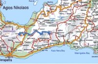 Richard Ellis walk: Day 4 at 11.5km (S) June 4th - There now followed two 30-plus kilometer days aggravated by the fact that I wanted to summit each range that I passed through - even though there is no strict E4 requirement to do this. So, I set off from Orino by 7.00 am on the clearly marked dirt road which is the pass through the mountains towards the village of Thripti. Distance:32.2 km Time: 11.5 hrs. Mov av 4.2 km/hr Height overnight: 330m.(max 1,476m.)  Pachia Ammos at 12.6km (SW) The Institute for Aegean Prehistory Study Center for East Crete (or INSTAP-SCEC) is a unique facility for archaeological research, especially in the area of Aegean Prehistory. The Center is committed to stimulating and facilitating publication in the broader field of Cretan studies, with a focus on archaeology and ethnology.
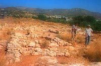
 Pahia Ammos, Ierapetra at 13.1km (SW) Gournia lies on a small hill, a few hundred metres from the sea in the Gulf of Mirabello, close to the north end of the Ierapetra isthmus ( 2 Km from Pachia Ammos village & 19 Km from Ag.Nikolaos). Gournia - the ancient name of which is not known - is the most characteristic of the excavated medium-size settlements, dated to the period of the peak of the Minoan culture (Late Minoan I period: 1550-1450 B.C.). It is called "Pompeii of Minoan Crete" because of the good state of preservation. It occupies a low hill, close to the sea, at the Isthmus of Ierapetra. Vassiliki - Archaeological Site Pahia Ammos, Ierapetra at 14.1km (SW) The ancient settlement of Vasilike is one of the first Minoan settlements with town-planning. It occupies the top and slopes of a low hill near the village Vasilike, in the vicinity of the Minoan settlement of Gournia. The first settlement dates back to the Early Minoan II period (2600-2300 B.C.) and owed its development not only to the strategic position, controlling the Isthmus of Hierapetra, but also to the neighbouring fertile plains. The central building of the settlement was destroyed by fire in around 2300 B.C.  Sitia, East Crete at 14.5km (SE) Péfkoi (GR: Πεύκοι). A typical Cretan village, built at 420m above sea level, with narrow paved streets and old stone built house. There are many places worth to visit in the area. The folklore museum, housed in a small well preserved building located by the old school, provides information on the history and the day to day life of the village. At the top of the overlooking hill, named "Kastelopoulo" there is a building of the Late Minoan period which used to be a watchtower or a beacon. The 7km long road from Makrygialos to Pefkoi passes through the "Pefkiano" gorge, a wonderful landscape with plenty of pine trees (=pefko) who gave their name to the village. Approaching the village we see the dirt road that leads to the miracle working church of Agios Georgios Semekides, celebrating every year at November 3rd. 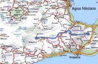 by Richard Ellis at 15.7km (SW) 5th June.- The GPS certainly gave me confidence whenever I came to junctions and occasionally the fairies who put up the E4 signs reassured me as well. If ever there was a “walk of the gods” it is here, as it contours round under Chalasmeni Korfi at over 1,000 metres and becomes steadily greener and more wooded. Distance:38.5 km Time: 11.5 hrs. Mov av 4.7 km/hr Height overnight: 887m.(max 1,100m.) 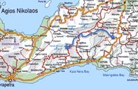 Richard Ellis walk: Day 3 at 16.8km (SE) June 3rd - ...The short, direct, one marked with E4 signs ends in an olive grove with no way out ! You keep climbing on the basis that you will meet up with the Anavasi version of the route and then all of a sudden you find the dreaded stock fencing. I was lucky to find a way through (over) it, scramble up and over a ridge and see the easier, but longer, dirt road alternative on the other side of a full-flowing river. However, my choice of route seemed to be what the EOS expects you to do, as suddenly, and quite unexpectedly, there was another rare E4 sign on my side of the road on the way down to the river... Distance:24.7 km Time: 9 hrs. Mov av 4.3 km/hr Height overnight: 605m.(max 775 m.)  North East Crete, Lassithi at 16.9km (W) Agios Nikólaos (GR: Αγιος Νικόλαος), with 9.500 inhabitants, is the capital of the Lassithi province of Crete. It is built around a picturesque lake at the north-western side of the Mirabello bay, the biggest bay in Crete. Major administrative, cultural and communications center, Agios Nikolaos is one of the most developed tourist areas, not only in Crete but in Greece in general. Thanks to the beautiful coasts, the great sights and the cosmopolitan life, this lively city hosts every year thousands of visitors without losing one bit of its tranquility and traditional hospitality.
Image Library
 Agios Nikolaos, Lassithi at 16.9km (W) The Folk Art Museum of Aghios Nikolaos, in collaboration with the "Cultural Society of Eastern Crete", founded in 1978. All the original and important material was generously offered by the Touring Club of Aghios Nikolaos. Since then more objects have been added to the collection. A visit to the Folk Art Museum will help you to become familiar with the sort of work and activities the people of this area had in the old days. The Museum houses a rich and beautiful collection of hundreds of genuine samples of Cretan popular art and mainly hand woven and embroidered pieces, some of which are unique.  Agios Nikolaos, Lassithi at 16.9km (W) Well protected Marina by all weather condition, build to European standards and capable to accommodating up to 255 boats all year round. The Marina of Aghios Nikolaos is located in the heart of the town, provides all the necessary facilities for a pleasant short or long stay for yacht passengers and a safe environment for the boats. Facilities: Water/Electricity:Each berth has access to a service box where fresh water and 220 / 380 volt electricity available.  Agios Nikolaos, Lassithi at 17km (W) Lake Voulismeni (Gr: Λίμνη Βουλισμένη) or just "the Lake" for the locals, is located at the centre of the town of Agios Nikolaos. It has a circular shape of a diameter of 137 m and depth 64 m. The lake connects to the harbour of the town by a channel dug in 1870. A panoramic view of the lake can be seen from a small park situated above it. According to legend, the goddess Athena bathed in it. Every year at midnight turning to Orthodox Christian Easter day, the majority of the population of the town gathers around the lake to celebrate with fireworks, and firecrackers. It was reported that the German army during their withdrawal from the area at WW2, disposed parts of their weaponry and/or vehicles into the deep lake. A local urban legend has it that the lake is bottomless. That notion is potentially based on its impressively disproportional high depth compared to its width (64m depth on only 134m width) or/and on locals noticing disturbances at the surface or also the level of the water during the Santorini (Thera) earthquake of 1956. Because of the latter, many assume a possible geological relation of the two locations, but this claim has not been substantiated by known scientific surveys to date. Image Library
 Sitia south at 17.1km (S) In 1971 systematic excavations were begun by the Ephor of Antiquities Kostis Davaras north-west of the village at Plakakia. Here he located an important villa of the lateminoan period. The dig was completed in 1977 having shown that the villa had been destroyed by fire.It had strong outer walls, inner courts, many rooms with thresholds, flagged floors and areas perhaps connected with the worship of the Sacred Tree. It must have been roofed with bamboo canes covered by a layer of clay (as a number of the older traditional village houses still are). Among the most important movable finds were vessels of pottery and stone, figurines and an amygdaloid seal-stone of steatite engraved with a representation of a Sacred Ship. On the ship a sacred precinct or altar is shown with a tall palm-like tree standing like a mast. On the prow of the ship a worshiper or a priestess stands facing the altar, clenched fist raised to the brow in the recognized Minoan attitude of worship. This is the first clear evidence of the existence of Sacred Ships or Boats connected with the Minoan religion; it has its parallels in the ancient religions of Egypt and Mesopotamia. Source: "Sitia" by Nikos Papadakis - archaeologist Image Library
 Agios Nikolaos, Lassithi at 17.2km (W) The Archaeological Museum of Aghios Nikolaos is one of the most important in Crete and has been in operation since 1969. It houses collections of very important archaeological finds from the whole of Eastern Crete, an area extending from Malia as far as Zakros. These are displayed in chronological order from the Neolithic period (5700 - 2800 B.C.) to the end of the Roman times (100 B.C. - 400 A.D.) Its showcases include more than 1350 vases from the 3rd millennium B.C. as well as gold and copper finds (the most ancient found in Crete).
 Sitia, East Lassithi at 17.2km (E) Piskokéfalo (GR: Πισκοκέφαλο), a principal village located 3 km south of Sitia. Piskokefalo is the birth place of the great poet Vincentzos Kornaros, who wrote the masterpiece of Medieval poetry, "Erotokritos". The village is mentioned at the census of 1577 by Fr. Barozzi, and became the seat of the commanding officer, after the destruction of the town of Sitia in 1538 by the pirate Chairentin Barbarossa. Nowadays Piskokefalo is a beautiful village where a stop is worthwhile. The visitor can see the house of Kornaros, enjoy a coffee or a meal at the village's square, visit the spring at Zou, the old water mill, the church of "Agia Anna" and the small chapel of "Panagia Trapezounta". 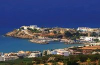 Sitia south at 17.3km (S) Makry Gialos (Long shore GR:Μακρύ Γιαλός) is a small beach resort on the south-east coast of Crete, located 60km from Agios Nikolaos, 25km from Ierapetra, and 33 km from Sitia. Makry Gialos features a small fishing harbour and a nice 1km long sandy beach that stretches from the harbour to the east. Four more lovely beaches can be found in the immediate area. Accommodation is available mostly in family-run studio and apartment complexes and there is a good choice of bars, restaurants, tavernas, some of them right on the beach front or at the small fishing harbour. Makry Gialos is the administrative centre of the wider area which comprises some picturesque traditional villages built on the tree covered mountain sides. The area has been inhabited since the Minoan times as many ruins from this as well as the Roman and the Venetian periods prove. 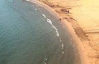 Sitia south at 17.3km (S) A one kilometre long beach, with fine gold sand and shallow waters, lies right in front of the town of Makry Gialos. It is accredited with the blue flag and is considered to be one of the safest beaches for swimmers of all experience and children due to its soft and gently shelving. It is an organised beach with sun-beds, umbrellas and most sea sports facilities. 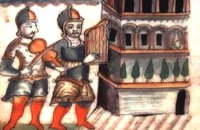 masterpiece of the Cretan Renaissance at 17.3km (E) Erotokritos (GR: Ερωτόκριτος) has been characterized as a masterpiece of the Greek language which unites the magic of myth and a deep understanding of everyday life. It expresses the "threefold ideal which is bravery, beauty and wisdom." A work rooted deeply in authentic Greek traditions, humanity, true feeling and pure love for life and freedom. The story takes place in Athens where King Herakles lives with his wife Artemis and their very beautiful daughter Aretousa, with whom the handsome and brave young man Erotokritos, son of the king's advisor, has fallen in love. After many difficulties and trials, the couple is married amidst celebrations and magnificent contests. The world of this work is the ideal Greek world of friendship, pure feelings, authentic Greek traditions. It is the world of the beauty of Athens and Crete which is "the throne of virtue and the river of wisdom." The language of this work is authentic Greek and Cretan, a synthesis and conscious effort of the poet to express lofty human feelings and values with simplicity, directness and truth. The poem was written by Vitsentzos Kornaros (1553-1613/14) a noble Cretan from Sitia with a very strong presence in Greek letters.  Cretan poet of the Greek Renaissance at 17.3km (E) Vitsentzos or Vikentios Kornáros (GR: Βιτσέντζος or Βικέντιος Κορνάρος) or Vincenzo Cornaro (March 29, 1553 – 1613/1614) was a Cretan poet of the Greek Renaissance who wrote the romantic epic poem Erotokritos. He was a leading figure of the Cretan Renaissance. Not many biographical sources exist about Kornaros himself apart from the last verses of Erotokritos. It is believed that he was born to a wealthy family in Trapezonda near Sitia, in 1553, and lived there roughly up to 1590. He then moved to Candia (present Iraklion), where he married to Marietta Zeno. Together they had two daughters named Helen and Katerina. Image Library
|
||
|
| ||


C
O
N
T
E
N
T
S
O
N
T
E
N
T
S