interkriti®
YOUR GATEWAY TO CRETE
HOME
CRETE FACTS
NAVIGATE
EXPLORE

Agia Galini
Triopetra
Kissamos
Chryssi Isl.
Agia Marina
Balos
Gavdos isl.
Georgioupolis
SAMARIA
IDA Mtn
Palaiochora
Agia Roumeli
Sfakaki
Bali
Kalamaki
Matala
Lassithi
Plateau Lendas
Tsoutsouros
Vianos
Myrtos
Sfakia
Plakias
Ierapetra
Makrygialos
ZAKROS
Vai
Sitia
Agios Nikolaos
Elounda
MALIA
Hersonissos
Gouves
Chania
Rethymnon
Heraklion
GORTYN
FESTOS
KNOSSOS
|
|
Crete
: Geography & Nature
List Grid Map
Found
45
- Showing :
1 - 20
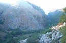
 Sfakia, South Hania The Samaria Gorge is one of the longest ravines in Europe (with a total length of 16 km) and offers one of the most spectacular hiking routes in Europe. Its width ranges from 150 m (widest part) to 3 m (narrowest part). The walk from Xyloskalo in the plateau of Omalos to the shores of Libyan sea at Agia Roumeli, takes 6 to 8 hours. The Samaria Gorge has been designated as a national park in order to protect its flora and fauna. It is one of the last shelters of the mountain goat of Crete (Cretan Ibex, common name : kri-kri). The flora is extensive, ranging from high cypress trees to flowers and herbs. The walking path follows the river which flows to small lakes and waterfalls. The Gorge is open to visitors from May to October. Image Library
 South east Iraklion Historical place with outstanding natural beauty, unspoiled villages and great beaches. The town of Ano Viannos is built amphitheatrically on the southern slopes of Dikti mountain at 560 m. above sea in a distance of 65km from Iraklion and 40km from Ierapetra. It preserves the traditional character with the narrow paved streets, the stone built houses - especially the "Plaka' quarter - the old kefeneios with tables under the plane trees and old churches such as Agios Georgios and Agia Pelagia with wall paintings dating back to the 14th century. There are a few accommodation facilities, banks, medical center, taverns, gas stations, shops etc. Ano Viannos is the seat of the municipality of Viannos.
 Psychro, Lassithi Plateau The cave of Psychro is one of the most important cult places of Minoan Crete. The excavators and several scholars identify the cave as the famous "Diktaian Cave", where Zeus was born and brought up with the aid of Amaltheia and the Kouretes, and which is connected with myths as this of the seer Epimenides who "slept" here, or the coupling of Zeus with Europa.
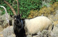 Cretan Ibex, Lefka Ori, Hania Kri-Kri is the common name of the Cretan feral goat (Capra aegagrus ssp. cretica) which is the largest wild mammal on the island. Its grandeur, its bravery, its ability to observe without being noticed, its speed and its impressive horns are the features that were loved by the locals and made it a symbol of Crete and the untamed Cretan spirit. It lives mainly on the White Mountains and its local name is "Agrimi" (GR: Αγρίμι = the wild one) for the male and "Sanada" (GR: Σανάδα) for the female. Recent years, young kri-kris have approached the old village of Samaria, where they are fed by the park rangers and can be seen by the visitors. Kri-kris and goats are close genetically, as the hybridization that exists between them show. Kri-kri's size however is a good deal larger than that of a goat Kri-kris have a strong sexual dimorphism. Males are larger than females. They all have horns, with annual rings and knobs, from which their age can be easily calculated. Males have larger horns than females (up to 90 cm), which curve backwards. An other characteristic of the males is the beard, which rarely occurs in females. Their coat is short and brown in summer and brownish and denser in winter. They have a black line on the back, which extends from the neck to the top of the tail while at its shoulders the line intersects with another one that reaches the stomach. There are also black patterns on the front parts of their legs. There are numerous representations of Kri-kris on ancient sealstones, vases and coins, indicating the esteem in which they were held by the people of antiquity. Phototograph by Anastassios Sakoulis - www.photophysis.gr Image Library
 Hania A guide to the area of Akrotiri. Tourist facilities, regional information and image gallery. Akrotiri with its scenic landscape provides a relaxing, refined country break away from the pressures of urban life. Its numerous monasteries, from the oldest in Crete, played a significant role in the history of the area. Gorges of outstanding beauty offer a unique hiking experience, breathtaking views and the joy of exploration...
Image Library
 Messara, South - West Iraklion Matala (GR: Μάταλα) was the ancient port of Phaistos and Gortys and a former fishing community which has developed into a modern holiday center. It is located 4 km south-west of the village of Pitsidia and 75 km from Iraklion. It is built on the coast line of the Messara bay inside a small and picturesque inlet. During the 60's the caves of Matala were hosting a hippie commune.
 Gournes The CretAquarium - Thalassocosmos (GR: Θαλασσόκοσμος) was officially opened in December 2005. It provides its visitors with a special experience, a trip to the underwater world of the Mediterranean Sea and its creatures. It is a unique park whose focus is on science, education, culture and recreation and whose goal is to promote, share and spread knowledge concerning the marine environment. Image Library
 Apokoronas, Hania Crete's only freshwater lake, Lake Kournás (GR: Λίμνη Κουρνά), is relatively large, with a perimeter of 3.5 km. Although almost all touristic leaflets say that it is possible to walk around the lake, that is not true. At least not at the end of the rain season (winter). There is a nature preserve on the Southwest of the lake. But there is a rustic road from the North of the lake to the Hills on the West of the lake too. Image Library
 Kenourgiou, Iraklion Agia Varvára (GR: Αγία Βαρβάρα) is a town built along the road between the Messara plain and the Malevizi region at the highest point (580 m). The town enjoys a unique location with a splendid view into the Malevizi region, and a cool climate, particularly pleasant during the hot summer months. It produces first-rate fruit and vegetables. Because of its strategic location on the main north-south axis, the town was often exposed to fierce battles. A famous warrior, Mathiou Kapitakis or Mathioudakis was born here: he fought side to side with Karaiskakis and was killed at Faliro. His comrade-in-arms, Logios, was the hero of Aghios Thomas. As you reach the village, on the north side there is a rock with a chapel dedicated to Profitis Ilias. On this rock -which used to be twice as large but part of it fell off at the beginning of the 19th century- there used to be an ancient temple. Nowadays, the visitor can find every kind of commodity and facility on hand at the modern town of Aghia Varvara. In summer a special 'tsikoudia' feast, and in early spring a carnival feast are organized by the Cultural Association of the town. At the centre of the town, there are two churches - one old and one new - both dedicated to the patron saint, Aghia Varvara. Three Byzantine churches are also well worth a visit: Profitis Ilias, Aghios Giorgos and Aghios Ioannis, and of course the old monastery of Aghia Pelagia by the cemetery. 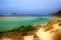 Gramvoussa Cape, Kissamos West of Kissamos and north of the beautiful village of Kaliviani, stretches the impressive Gramvoussa peninsula. The peninsula is formed by steep rocks and is covered with thyme and origanum bushes and wild flowers. On the north west side of the peninsula opposite to the island of Gramvoussa is the wonderful beach of Balos (GR: Μπάλος). The beach is covered with fine white sand and is located between the two creeks of the Tigani cape. The same white sand covers the bottom of the sea and grants to the sea an emerald color. In front of the beach is the picturesque island of Gramvoussa and on the back is the Geroskinos mountain (altitude 762 m). The road from Kaliviani is well paved dirt road, with amazing view to the steep rocky seaside of the east side of the peninsula. The road ends one-two km before the beach, and the visitor can follow a paved road to Balos. North of Balos, at the Korykon cape, are the ruins of the small Roman city of Agnion, with a temple of the God Apollo. There are small boats, offering daily cruises to Balos and Gramvoussa, departing from Kissamos (Kastelli) during the summertime. Image Library
 South west Kissamos Elafonissi is a small islet on the southwest of Crete. It is connected to the beach with a shallow reef (max. depth 1 meter) that allows crossing when the sea is calm. There are only a couple of cantinas on the beach and plenty of places for camping. The place can be accessed by car from the village of Vathi or by boat from Paleohora. There are no permanent inhabitants.
Image Library
 Kissamos A small village 21km away from Kastelli Kissamou,at 340 m. a.s.l with 57 permanent residents. The village is mentioned by Fr. Barozzi since 1577. A little before the village of Sassalos, starts the gorge of Salasse, a small one which leads to Tyflos river, and is worthy to walk.
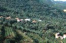 Kissamos, Hania Vlatos is located at 380m a.s.l., 54 km away from Hania and 18 km from Kastelli Kissamou. It is built in a tree covered valley, with olive trees, chestnut trees and wild vegetation. There are some very nice trekking paths around and in the forest of "Peace" which has been characterized as a natural park. The "Park of Peace" was founded in 1970 by the Cultural Association of Vlatos with the cooparation of Goethe Institute and the support of the Bavarian Department of Forests. It is an experimental park with 150 species of plants, covers an area of 1,000,000 sq.m. and is part of an extended area of 20 sq.km. which have been reforested.  Sfakia, South Hania The ravine begins from the last houses of the village of Imbros and 8 km after it ends at the village of Komitades. Its crossing is smooth and entails no danger...
 Sfakia, South Hania Kalikratis is a small mountainous village at the foot of the White Mountains (Lefka Ori) at an altitude of 750m above sea level. It is a traditional village with many well preserved stone houses. A German army of two thousand soldiers, invaded the village during the October of 1943 , burned it down and executed twenty men and nine women who did not manage to leave on time. A little to the south of the village starts the gorge of the same name which is part of the European hiking footpath (E4) and after some 4km walking ends at the village of Patsianos.  Psiloritis Mountain At 1538m above sea level, 20 km. south of the traditional town of Anogia , on the plateau of Nida, of Mountain Psiloritis, lies this sacred cave, where according to mythology, Rhea, Zeus' mother, hid the new born Zeus in this cave in order to protect him from his father Kronos (Saturn), who was in the habit of swallowing his children because he feared they might deprive him of his power. Hidden in that cave Zeus grew up being fed with the milk of the goat Amalthia, while the 'Kourites" covered the child's crying through banging their copper shields. Image Library
Weather Stats for Iraklion Iraklion Temperature - Precipitation - Wind Speed - Morning Relative Humidity
 Skotino,Gouves, Iraklion This is one of the three largest caves in the prefecture of Heraklion. It lies at half an hour distance to the north-west from the village of Skotino and is at a height of 225 m. above sea-level. The entrance to the cave is impressive: a large arch, 27 m wide and 10 m high. To the right one can see the ruins of an ancient chapel on which the modern chapel dedicated to Aghia Paraskevi was built. There is a feast held in front of the chapel on July 26th .
 Mires, Messara Valley It is located north of Mires close to a small gorge, with springs and covered with trees. There are many churches in the village the most important one being the church of Agios Nikolaos, a domed church dated to the 13th century. The walls of the temple are hand painted with biblical scenes and pictures of saints
The Municipality of Asterousia
South Iraklion The mountain range of Asterousia (Eastern part), the beaches, the facilities, the sightseeing and the villages: AGIA FOTIA, AMYGDALOS, APOSELEMI, AHENTRIAS, VORIAS, DORAKI, ETHIA, KALIVIA, KEFALADO, LIGORTINOS, MADES, MESOHORIO, MOURNIA, NEOHORI, PARANIFI, PLAKIOTISA, PRINIAS, PROTORIA, PIRATHI, PIRGOS, ROTASI, TEFELI, HARAKAS, HARAKI, TREIS EKLISIES, PERA TSOUTSOUROS, MARIDAKI, AGIOS NIKITAS MONASTERY... |
||
|
| ||


C
O
N
T
E
N
T
S
O
N
T
E
N
T
S