|
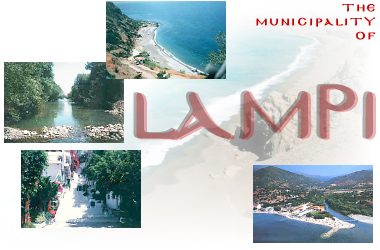
GENERAL INFORMATION
Telephone number of the municipality:
+3 28320-22046
Fax number: +3 28320-22777
The municipality of Lambi lies to the south of the prefecture of Rethymnon and borders with the following municipalities: Rethymnon to the northwest, Kouriton to the east and Foinika to the west. The Lybian Sea marks its southern border.
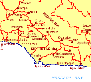
The municipality comprises the following districts: Aghia Galini, Akoumia, Ardaktos, Drimiskos, Karines, Kentrochori, Kerames, Kissos, Krya Vryssi, Lambini, Melambes, Mournes, Myxorrouma, Orne, Saktouria, Spili.
The municipality covers an area of 221 square kilometers and has a population of 6000 inhabitants.
The following high peaks mark the landscape: Mount Kedros (1777 m), Mount Asideroti , Mount Xiro (904 m).
Olive groves, springs, streams, exotic flowers and a profusion of plants meet the eye as one makes one's way down the mountains to the crystal clear waters of the Lybian sea.
Three rivers cross the municipality: Plati or Elektras that joins the sea at Aghia Galini, the Megapotamos or Kourtaliotis famous for its lake down at Preveli beach, and the river Akoumiano.
Because of its varied landscape, the area is ideal for nature-lovers and well suited for trekking.
The seat of the municipality is Spili, which is also the ecclesiastic seat of the bishopric of Lambi and Sfakion.
The economy of the region is based on agricultural produce and livestock, including manufactures of cheese, olive oil press, and so on. Tourism too is an important source of income for the region.
Top
HISTORICAL BACKGROUND
The coast to the south of the prefecture of Rethymnon is known as Gialia. In Greek mythology, the islands Dionysios (also known as Paximadia), which form part of the mythical Gialia region and belong to the municipality of Lambi, belonged to the god of wine, Dionysios. There are too, a great many Byzantine and Venetian vestiges scattered all over the region, properly cared for by the inhabitants who are very conscious of their historic value.
Top
TOURISM
A visit to the municipality of Lambi will give visitors the possibility to share both the mountainous beauty of Crete, as well as the beautiful crystal clear waters of the Lybian Sea.
In all the area, but especially along the coast, visitors can stay in family-run pensions and rooms, often including local tavernas.
Drimiskiano Ammoudi, Triopetra, Aghios Pavlos, Aghios Giorgos are only a few of the many little quiet places where one can spend a restful holiday.
On the other hand, Aghia Galini located at the east end of the municipality on the border with the Messara plain, is a hot place for tourists, teeming with all the attractions a more active and modern visitor would wish for, including not just comfortable hotels and furnished apartments, but also camping sites, tourist agencies, car-renting offices, restaurants, tavernas of every kind and for every taste, discos and other recreation centres, shops at every price, etc.
Top
VILLAGES AND SETTLEMENTS IN THE MUNICIPALITY OF LAMBI:
SPILI
Spili is the county town and has about 800 inhabitants. It is 30 km away from Rethymnon, along the road that goes from Rethymnon to Armenoi and then Spili. The town lies at a height of 430 m above sea level, at the foothills of Mount Vorizi, which belongs to the Kedros chain. In Venetian times the town consisted of several neighborhoods and Spili is quoted in all the censi, Turkish and Venetian, including the Egyptian one. In 1881 it is recorded as the seat of the province of Lambi, with about 600 inhabitants. In 1900 it is recorded as having 750 inhabitants. From 1928 onwards, Spili became the name of the whole commune.
There are old churches in Spili with wall paintings: Aghios Giorgos, Aghios Theodoros, the church of the Sotir and that of the Panaghia. The beautiful church dedicated to Saints Peter and Paul is nowadays the ecclesiastic see of Lambi and Sfakia.
There are two old mills close to the town of Spili which are in good condition and well worth a visit.
At present, Spili is a modern town, with all the facilities and services required by the locals and by the large number of visitors.
Top
AGHIA GALINI
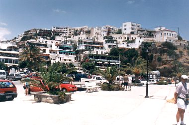 |
This large seaside village of the municipality of Lambi counts 1041 inhabitants. It is a well organized tourist resort with comfortable hotels, apartments, camping sites, tourist agencies, car-renting offices, restaurants, tavernas and other recreation centres, as well as all the facilities required by tourists and locals alike.
Aghia Galini is a new village, founded in 1884 by villagers from Melambes. The name, though not to be found in the censi, is very old, as is the name of the river Platis or Amarianos, and ancient maps mention the same river under the name of Elektra.
In ancient times there used to be a settlement called Soulia or Soulina in exactly the same place, which was the port of ancient Syvritos. Artemis was the goddess adored here in that remote age, and the church of Galini Christos, visited by Buondelmonti in 1415, was built on the ruins of her temple. We therefore draw the conclusion that the present-day Aghia Galini owes its name to the monastery of Galini Christos.
There are several caves along the coast, where the sea plays games with the rays of the sun, recalling similar grottoes in Capri …
Top
AKOUMIA
This village in the municipality of Lambi counts 699 inhabitants. It lies at 530 m above sea level and is 39 km from Rethymnon, on the road Spili-Kambos Kissou-Akoumia-Melambes.
This village is recorded in the Venetian censi of the 16th and 17th centuries under the name of Koumia. In 1834 it is incorrectly referred to as Akoumia and in 1842, Chourmouzis Vizantios mentions it again as Koumia. In 1881, it is quoted among the villages of the municipality of Aghios Pnevmatos, under the name of Koumia, with 660 inhabitants and again in 1900 with 810. As of 1920, the village is definitely known as Akoumia, though in fact Koumia is the right name.
The village had a two-storey Turkish tower with large windows. The church of the Sotir is still in good condition showing wall paintings of the 14th century.
The river takes its name from the village, and is known as Koumiamnos.
In 1868 a fierce battle took place against the Turks and many rebels lost their lives.
ARDAKTOS
This village in the municipality of Lambi counts 239 inhabitants. It lies at 630 m above sea level and is 40 km away from Rethymnon, on the road Spili-Timbaki (turn right at the 35th km).
This old settlement is recorded in the Venetian censi of the 16th and 17th centuries.
In 1881, it is quoted among the villages of the municipality of Aghios Pnevmatos, under the name of Ardaktos, with 157 inhabitants. In 1900 it has 210 inhabitants according to the census of that year and in all subsequent records it bears the name of the commune called after it. The name probably has its origins in the flora of the area, Atraktylis or Maloti, a widespread plant with therapeutic values to be found in the region.
DRIMISKOS
This village in the municipality of Lambi counts 239 inhabitants. At 440 m above sea level, the village is 45 km from Rethymnon, on the road Spili-Aktounto-Ardaktos-Drimiskos.
This old settlement is recorded in the Venetian censi of the 16th and 17th centuries.
In 1881, it is quoted among the villages of the municipality of Aghios Pnevmatos, under the name of Drimiskos, with 170 inhabitants. In 1900 it has 233 inhabitants according to the census of that year and in all subsequent records it is bears the same name as the commune.
There are some ruined Byzantine churches around the village, with wall paintings in very poor condition. Some paintings in the church of the Dormition (Koimisi tis Panaghias) are by Michail Veneris.
A dirt road leads from the village to the beach, a short distance away. This beautiful and remote beach of Drimiskiano Ammoudi has a footpath leading to the beach in Preveli called Limni. There are a few facilities on the beach (rooms and modest tavernas).
Top
KARINES
This village in the municipality of Lambi counts 80 inhabitants. Located at 540 m above sea level, it is 35 km from Rethymnon, right turn on the road to Spili at the 26th km towards Lambini-Karines.
This old settlement is recorded in the Venetian censi of the 16th and 17th centuries.
The church of Aghios Giorgos has a nice representation of the donors holding up the church. This charming wall painting is well worth seeing.
The church of the Timios Stavros (Holy Cross) dates back to 1601.
In 1881, it is recorded among the villages of the municipality of Meronas Amariou with 252 inhabitants. In 1900 it has 233 inhabitants according to the census of that year and in all subsequent records it has the same name as the commune.
The village is built on a hill, like the castles of towns called Karina by Homer, and this, according to Professor Pelantakis, is the origin of the name of the village.
KENTROCHORI
The village is known as Kentrochori or Kedrochori or Vouidomagergeio.
This village in the municipality of Lambi counts 184 inhabitants. It lies at 530 m above sea-level, on the south flank of Mount Kedros, and 37.5 km away from Rethymnon, at the left turn on the road Spili-Aghia Galini (37th km towards Lambini-Karines).
This old settlement is recorded in the Venetian censi of the 16th and 17th centuries as Vouidomagergeio.
In 1881, it forms part of the municipality of Aghios Pnevmatos, under the name of Doumaergiome, with 195 inhabitants. In 1940 it was baptized Kentrochori.
The monastery of Aghios Pnevmatos, belonging to the bigger and more important monastery of Preveli, is not far from the village.
Top
KERAMES
This village in the municipality of Lambi counts 254 inhabitants. It lies at 300 m above sea-level and is 34.5 km away from Rethymnon, on the road Kissos-Aktounta-Ardaktos-Drimiskos Kerame.
This old settlement is recorded in the Venetian censi of the 16th and 17th centuries, as well as in the Turkish and Egyptian censi.
In 1881, it is quoted among the villages of the municipality of Aghios Pnevmatos, with 337 inhabitants. In 1900, in the same municipality with 440 inhabitants. In 1920, Kerames is a municipality in its own right and has 516 inhabitants and as of 1928 it is quoted as the seat of the commune with the same name.
The village probably owes its name to the word Potter in Greek. A resident of the village, Konstantinos Spyridakis, founded an interesting folklore museum with a rich collection of coins, arms belonging to Cretan fighters and other works of art.
KISSOS
Located on the south flank of Mount Kedros, at a height of 630 m above sea-level, this village, together with the settlement of Kambos Kissou a bit further down, belongs to the municipality of Lambi and has 254 inhabitants. It is located at the 35th km of the road Rethymnon-Spili-Kampos Kissou-Aghia Galini.
Byzantine churches in good condition can be seen in the village, with interesting wall paintings of Our Saviour (Sotir), the Panaghia (Our Lady) and Saint John (Aghios Ioannis).
The village is mentioned by name in the Venetian censi.
In 1881, it forms part of the municipality of Aghios Pnevmatos and has 210 inhabitants. As of 1940 it becomes the seat of the commune with the same name.
Top
KRYA VRYSSI
Situated on the south side of Mount Kedros, at an altitude of 480 m above sea-level, this village has a lot of water, hence its name Krya Vryssi which means Cold Spring.
The village belongs to the municipality of Lambi and has 207 inhabitants and is on the 45th km of the road Rethymnon-Timbaki. The new settlement of Nea Krya Vryssi is just 1 km away , on a slightly lower level, i.e. 440 m above sea-level.
The village is mentioned by name in the Venetian censi.
In 1881, it forms part of the municipality of Melambes and has 327 inhabitants. As of 1940 it becomes the seat of a commune with the same name.
LAMBINI
The village belongs to the municipality of Lambi and has 154 inhabitants. Turn left at the 26th km of the road Rethymnon-Spili.
The name finds its origin in the ancient town of Lappa-Lambi.
The village is mentioned by name in the Venetian censi of the 16th and 17th centuries, as well as in the Turkish (1659) and Egyptian (1834) censi.
In 1881, it forms part of the municipality of Lambi and has about 190 inhabitants, and in 1920 it counts 154 inhabitants. The name changes to Lambrini and then again to Lambini in 1928, with 215 inhabitants, in the municipality of Mixorrouma.
As of 1940 it becomes the seat of a commune with the same name.
The church of the Panaghia, with its splendid dome and central nave has parts dating back to the 14th century, as can be seen from the architecture of the building and the wall paintings.
The present day church is a restoration of the older building dating back to the first years of the Venetian occupation of the island. In spite of the Turkish Occupation, the church has weathered well and some of the wall paintings are in not too bad condition. There are tombs under the floor of the church, where possibly the donors, or the bishops of Lambi as was the custom, lie buried.
MELAMBES
The village belongs to the municipality of Lambi and has 790 inhabitants. It is located at the 51st km on the road Rethymnon-Spili-Melambes-Timbaki.
It lies at an altitude of 570 m above sea-level, in the valley between Mount Kedros (1777 m) and Mount Vouvala (947 m).
The village is mentioned by name in the Venetian censi.
In 1881, it is the seat of the municipality of Melambes and has 1002 inhabitants. In 1900 it has 1180 inhabitants and in 1951, 1401.
According to the teacher of Rethymnon, Emmanouil Lambrinakis, Melambes was built after Lambi was destroyed and the name Melambes means "Me, Lambi".
Panos Koronaios had his rebel camp in 1866, with Michail Korakas and another thousand men.
Below Melambes, at a place called Kouroi, there was a temple dedicated to Elektra, hence the name of the river Elektras.
Top
MOURNES
The village of Mournes forms part of the municipality of Lambi and is located at an altitude of 600 m above sea-level. It has 241 inhabitants. It lies to the south-west of Spili at a distance of 34 km from Rethymnon.
It is recorded as Mournea in all the Venetian censi.
In 1881 it is recorded as Mourne in the municipality of Lambi with 380 inhabitants. In 1900 it has 462 inhabitants and after 1920, it becomes the seat of a commune bearing the same name, Mournes.
At Malathre, close to a spring, to the south-west of the village of Diplochori - now in ruins -the church of Aghios Giorgos has interesting wall paintings, albeit in poor condition.
MYXORROUMA
The village of Myxorrouma forms part of the municipality of Lambi and is located at an altitude of 300 m above sea-level. It has 394 inhabitants. It lies on the road to Spili, at the 26th km, 26,5 km from Rethymnon.
It is quoted as Myxorrouma in all the Venetian censi.
In 1881 it is recorded as Myxorrouma in the municipality of Lambi with 126 inhabitants. Later, in 1900 it has 146 inhabitants.
The origin of its name is to be found in the two Greek words "mixis: and "rouma", after its location at the junction of two torrents.
The old village of Myxorrouma is well worth a visit, with its stone houses and lush vegetation.
ORNE
The village of Orne forms part of the municipality of Lambi and is located on the south-eastern flanks of Mount Kedros, at an altitude of 300 m above sea-level. It has 123 inhabitants. It lies on the road to Aghia Galini-Krya Vryssi, turning left at the 45th km and at a distance of 49 km from Rethymnon.
It is recorded in all the Venetian censi.
In 1881 it is recorded in the municipality of Melambes, until 1940 when it becomes the seat of a commune with the same name.
SAKTOURIA
The village of Saktouria forms part of the municipality of Lambi and is located at an altitude of 540 m above sea-level. It has 311 inhabitants.
At a distance of 49 km of Rethymnon, right turn at the 47th km on the road Rethymnon-Spili-Melambes.
It is recorded as Sacturia in all the Venetian censi of the 16th and 17th centuries. Chourmoutzis Vizantios calls it Sachtouri.
In 1881 it is recorded as forming part of the municipality of Melambes with 360 inhabitants and in 1900, still in the same municipality until 1940 when it becomes the seat of a commune with the same name.
The village owes its name to the Greek word 'sachtouri' which refers to a sailing boat of 15 to 20 tons with square sails. Therefore the name should be Sachtouria and not Saktouria, as it is known today.
Top
|