Rethimno
Crete
The area of PLAKIAS
|
|
|
|
|
|
|
|
|
|
|
|
|
|
|
|
|
|
|
|
|
|
|
|
Villages

Access
| From Rethymno to Plakias |
Followng the signs to "SPILI" we are leaving the city of Rethymno, taking the asphalt road to the south. Some 8.5 km from Rethimno a sign points to the Archaeological site of the "Late Minoan Cemetery" which is located about 20 meters to the right.
One and a half km after the Archaeological site stands the village of Armenoi, where you can find a card phone, a grocer's shop, cafes etc.
There is a large parking area and the small stone built guard's hut at the entrance of the site.
Both the site that is located at an oak covered hill, as well as the vaulted Minoan tombs will impress you.
The site was first discovered by a teacher who saw some kids playing football with a minoan vase!. He mentioned the fact to the authorities and the excavations that followed unearthed about 300 tombs of the Late Minoan III period (1450-1100 BC). As the tombs had not been yet looted, the archaeologists found significant treasures like vases, weapons, statuettes, jewels etc.
It is obvious that such a big cemetery should belong to a big city which, despite the extended investigations of the archaeologists, has not been discovered yet.
 |
Ten kilometers after Armenoi is a crossroad where you will find a gas station and two taverns, open from early in the morning to late in the night. At this point you have two options, for the course to be followed. Both lead to Plakias with a small difference in their length but if your final destination is Fragokastelo and Sfakia then you have to take the road to the right.
This route, after some two km reaches the beautiful village of Agios Vassilios which is built among vine and olive groves and gave its name to the hole county. During the the 2nd Byzantine period it was the seat of the district of "KATO SYVRITOS" and during the Venetian occupation the seat of the "CASTELLANIA BASEIO".
A walk through the narrow paved streets of the village with the old stone built houses, will give you the opportunity to meet the hospitable people, learn its history, visit the beautiful church with the important belfry, the war memorial, and enjoy a raki or a Greek coffee at the villages square, under the perennial plane trees.
There is also a small cave with stalagmites in the village, but the access is quite difficult, as the entrance, which is from a house's yard, is extremely narrow. A pocket torch is essential if one wants to explore the cave.
Leaving the village of Agios Vassilios we continue our journey passing from the small village Agousseliana, and after a 2km drive among trees like cypress, plane trees and arbutus we reach Agios Ioannis. A stop here is also worthwhile.
Built at 460 m a.s.l. Agios Ioannis is one of the three settlements of the municipality of the same name, while the other two, Kanevos and Kali Sikia, are located in a small distance from Agios Ioannis.
 |
A little to the north of the village starts the cypress forest covering an area of 450,000 sq.m. with rare species of the Cretan flora and fauna. This region is today under protection by the authorities. There are walking paths for the nature lovers and the numerous botanists visiting every year the place which among others is of significant scientific interest.
The village is mentioned since 1577 from Fr Barozzi to be part of the county of Agios Vassilios. In 1770 the Turks burned the church of "Agios Ioannis" which was rebuilt and dedicated this time to "Agios Georgios". A significant battle took place here during the revolution against the Turks, when Vourdoumbas, Kourmoulis and other revolutionists stopped the enemy's advance.
Kanevos is located just before the entrance of the "KOTSIFOU" gorge at 450 m a.s.l. There are a couple of good taverns with rooms for rent, operating all year around, for those who want to make Kanevos their starting point for excursions to the broader area. The name "Kanevos" is considered to be of Venetian origin (caneva= wineshop) as in the past there were some renowned inns here.
A sign just before the gorge points to the village "Kali Sikia" located a few kilometers to the west. We take this raod having on the left hand the gorgeous pick of "Tsilivdikas" and the impressive "Kaliskiano" gorge.
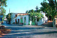
Mirthios is a small village with 224 permanet residents built on the southern slope of the mountain "Kouroupa" (984m), 36 km from the city of Rethimnon.
From Mirthios one route leads to the beautiful village of Mariou and another to Plakias.
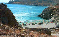
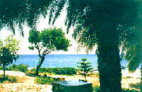
Plakias is a coastal settlement at the southern Crete,
40 km south of Rethimno, with 237 permanent residents, built at the cove of the bay of the same name on a wonderful sandy beach, 1300 m long, between the capes Stavros
and Kako Mouri, that is ideal
for swimming and sea sports.
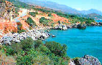
Damnoni is a beach within a few kilometers to the east of Plakias. It used to be one of the cleanest and most attractive beaches for the lovers of camping and naturalism during the 70's. Nowadays that large hotels are built there, Damnoni became a popular tourist resort getting fairly crowded especially during the high season.
Kali Sikia, was mentioned by Fr Barozzi at his 1577 census to be comprised of two separate settlements, Pano and Kato Kali Sikia. Emm. Lamprinakis, a teacher from Rethimno, writes that in 1830 Mohamad Ali had a coal mine at Kali Sikia.
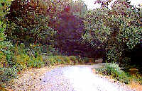
From Kali Sikia there is an up-hill dirt road through an impressive landscape which leads to the village Velonado. Experienced walkers or bicyclists will enjoy this route, which is however recommended to start from Velonado.
Leaving behind the villages of the municipality of Agios Ioannis, we drive to the south through the "Kotsifou" gorge. The road stretches like a snake along the high vertical walls and after a few kilometers we have in front of us the imposing view of the southern coastline. Now the road splits in two: to the righ towards the village Selia and then Rodakino, Fragokastelo, Sfakia, and since our destination is Plakias it is better to take the road to the left and access the traditional village of Mirthios
It is the birthplace of the linguist George Hatzidakis and his brother John both wellknown university professors.
The name Mirthios (or Mirtos) is believed to come from the plant "mirsini".
Mirthios is an old (first mentioned at the Fr Barozzi's census in 1577) traditional village with picturesque paved narrow streets and stairs, and a breathtaking view of the bay of Plakias and the surrounding mountains.
One of the places worth to see is the old small church of "Metamorfossis tou Sotiros", with remarkably well preserved frescoes.
The visitor can enjoy the cretan specialties at the small taverns of the village. Some rooms are available to rent for those who want to spend the night at Mirthios or make it their starting point for exploring the surrounding area.
Plakias belongs to the municipalities of Selia (the western part) and Mirthios (the eastern part) a couple of picturesque villages located not far from Plakias.
The first mention of Plakias was in the census of 1961 when only 6 fishermen were its permanent inhabitants. The natural beauty of the place helped Plakias to become a renowned tourist resort now providing all the facilities that a visitor could wish.
Large hotels, youth hostel, small traditional style apartments, camping site, taverns, restaurants, bars, everything to make the visitors' stay comfortable and unforgetable. There are many small secluded beaches for the naturalism lovers as well as some organized ones providing quite few facilities such as sun chairs, umbrellas, sea sports etc.
Starting from Plakias to the east we can access the beach of Paligremnos, at the eastern side of the bay of Plakias, or continue to the neighboring cove of Damnoni.
The beach now provides umbrellas, sunchairs, and sea sports while
two taverns located on the beach offer good food and fresh fish.
 |
There are however more secluded beaches, not far from Damnoni accessible by the sea or even by car (dirt road).
A dirt road only a few kilometers long, starts from Damnoni and ends at the small cove of Ammoudi where there is a beach ideal for camping with quite few trees, running water a tavern and a small hotel. The beach is also accessible from the village of Lefkogia, via an asphalt road at a point of which an intersection leads to the wonderful beach of Shinaria located in a small cove east of Ammoudi. We will find there a tavern with good food and service.
Some really nice beaches are located west of Plakias, the first being this of Gavdolimano. Continueing to the west we will find the wonderful beach of Souda, with palm trees, fine sand, clear water and quite few facilities such as small hotels and lovely taverns.
 |
Taking the road back to Mirthios and five km from Plakias along a route with a panoramic view to the coast and the surrounding mountains, we reach Mariou, a picturesque village built on the southern slope of Kouroupa. At the entrance of the village we meet the church of "Ipapanti" a place which invites you to make a stop and admire the view and the old church's architectural style.
At the village' s quare you will find some traditional cafes, a card phone and some interesting traditional shops(!)
Mariou is mentioned in the 1577 census of Fr. Barozzi being thereafter always inhabited. The name comes probably from a noblewoman "MARIA" who used to live here.
Leaving Mariou we take the road to Asomatos, a 3.5km drive and then turning to the right we take the road which, passes through the impressive Kourtaliotiko gorge and reaches after 6km the monastery of Kato Preveli.
Kourtaliotiko Gorge
The strong winds make the steep rocky walls to whistle, and sweep small stones that tumble and crackle. This noise gave the name "kourtaliotiko" (=crackling) to the gorge.
A little before the exit of the gorge there is a small waterfall, about 40m high. The water comes out of five points and flows all year around.
| A legend says that those five springs were made from the imprint of the fingers of Saint Nicholas, an ascetic who was born in the nearby village Frati and used to live there years ago, on arock. This was a miracle that happened because the ascetic had no water an was about to leave the place. In memorial to this Saint, which is celebrated at September 1st, the local people called the spring "evlogia kiriou" (Lord's blessing) and built a small chapel a little further from that spring. S.Spanakis KRITI v.B' |
The monastery of Preveli
It stands 37 km south of Rethimnon, in an imposing landscape which is mentioned at the mid-19th century diary of Sir John Spratt (admiral of the British Royal Navy), as "one of the happiest places to withdraw from trials and responsibilities of life".
There are lots of legends concerning the foundation of the monastery, which is believed that started during the Venetian occupation of the island. A number of its monks activities made the monastery one of the richest of western Crete and due to its isolated position it played important role in Cretan revolts against the occupying forces.
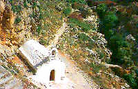
The monastery consists of two separated blocks, "PISSO MONASTIRI" and "KATO MONASTIRI". Arriving from Rethimno we first meet Kato Monastiri with the church of "Agios Ioannis o Prodromos" today being isolated and after two kilometers to the south we meet Pisso Monastiri, most renowned to the visitors, dedicated to "Agios Ioannis o Theologos" inhabited by only one monk.
The exisiting buildings are not the original ones, but what is left from the Turks distructions and the later modifications and extensions.
There are many valuable relics kept in the monastery such as:The icon of Christ "king of the kings" work of the painter Michail Prevelis (1750),
The icon of "Agios Ioannis o Theologos" (13th century)
The miraculous Crucifix (18th century)
The splendid iconostasis and many others.
Both Palm Beach (Limni) as well as the monastery of Preveli can be accessed from the village Lefkogia, located a little to the north of the beaches of Ammoudi and Shinaria. Lefkogia is a small village with 239 inhabitants, which together with the small settlement of Gianniou (60 inhabitants) comprise the Municipality of Lefkogia. The name comes from the white (=lefko) and land (=gea) and has to do of course with the color of the land of the area.
From Lefkogia we take the road to the right which leads to Gianniou and from here a dirt road will take us to the Pisso Monastiri of Preveli.
From the monastery there are some walking paths leading to the Palm beach from the west, but an easier route is to go back to Kato Monastiri and after 500m take the road to the east which after about 2km reaches at parking area where a couple of taverns stand. Ten minutes walk away is the Palm Beach.
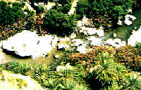 |
The gorge that forms the river "megapotamos" ends at the Libyan Sea creating a small lake at its delta.
This lake surrounded by palm trees and rich vegetation is one of the most attractive places in Crete and once used to be an ideal place for camping and naturalism lovers.
The sea is clean with a dazzling range of green and blue colors.
The place is accessible only by foot or by boat. Many organized cruises start from Plakias or Agia Galini to bring visitors at LIMNI which can be fairly crowded during the high season. Only a few facilities are provided to the visitors.
On our way back to Iraklion or Rethimno, we choose to take the up-hill road through the Kourtaliotiko gorge (at least 2.5km of this course is inside the gorge) and access the village Koxare.
Koxare and the neighboring village of Atsipades together with the settlements of Bale, Tsikalario and Katsogrida comprise the municipality of Koxare.
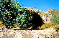 |
The area is covered with olive trees, vine yards and plane trees while the megapotamos river, which flows through it, forms a really wonderful lanscape. There are some significant monuments of the Cretan culture and history such as the stone built bridge by the megapotamos, the ruined Venetian fortress, the chapel of Agios Georgios as well as a folklore museum.
The visitor will find some good taverns with local specilties and a pension for accommodation. There is also a gas station.
Pictures
.
The area provides
all the facilities for tourists.
Hotels, apartments, camping, and of course lots of bars, restaurants and taverns serving fresh fish and specialties from the local and international cuisine.
 |
There is also a dock for small boats. Many cruises to the broader area such as Sfakia to the west or Matala, Agia Galini and Preveli to the east are scheduled in the summer time.
|
|
|
| Navigate | Introduction |
| Map | Road Map |
| Regional Index | Bulletin Board |