interkriti®
YOUR GATEWAY TO CRETE
HOME
CRETE FACTS
NAVIGATE
EXPLORE

Agia Galini
Triopetra
Kissamos
Chryssi Isl.
Agia Marina
Balos
Gavdos isl.
Georgioupolis
SAMARIA
IDA Mtn
Palaiochora
Agia Roumeli
Sfakaki
Bali
Kalamaki
Matala
Lassithi
Plateau Lendas
Tsoutsouros
Vianos
Myrtos
Sfakia
Plakias
Ierapetra
Makrygialos
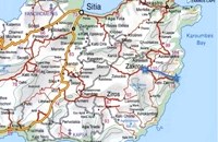
ZAKROS
Vai
Sitia
Agios Nikolaos
Elounda
MALIA
Hersonissos
Gouves
Chania
Rethymnon
Heraklion
GORTYN
FESTOS
KNOSSOS
|
|
Crete
List Grid Map
Found
42
- Showing :
21 - 40
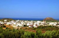
 Sitia, East Lasssithi at 13.1km (N) The easternmost town in Crete. A small and pleasant coastal town, built in a semicircle on the western side of the Bay of Sitia (Si̱teía GR: Σητεία), a typical, peaceful Mediterranean port. It is the capital of the county with the same name and is sited 69 km east of Agios Nikolaos.
Image Library
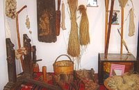 Sitia town at 13.2km (N) The Folklore Museum of Sitia (Siteia, GR: Σητεία) displays items from the 19th and early 20th centuries. It includes some unique embroidery, examples of traditional weaving, wood carvings, local dress and household items, all displayed in an authentic Sitian house setting. Address : 28, Kapetan Sifi Str., 72300 Sitia 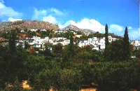 Sitia, East Crete at 13.5km (E) A picturesque town built at 260 m. above sea level, located at the end of the road from Sitia to the eastern part of the island, 38km away from Sitia and 19,5km from Palekastro. Zakros has 750 inhabitants, farmers, producing olive oil of excelent quality, stock breeders and fishermen. It is the commercial and administrative center of the area with the villages : Adravasti (75 inhabitants, 300m a.s.l.), Azokeramos (58 inhabitants, 230m a.s.l.), Kelaria (34 inhabitants, 250m a.s.l.), Klissidi (15 inhabitants, 220m a.s.l.) and Kato Zakros a small coastal village, site of the fourth large Minoan Palace, located 7.5km from Zakros at the bay of the same name. There is regular public bus transportation from Sitia to Zakros. The town and the wider area offers quite few facilities to the visitors, apartments for rent, restaurants cafes, shops etc. During the summer cultural events are taking place at the central square of the town, attracting both tourists and locals. The area is characterized by lush vegetation, due to the many springs and streams with running water, while watermills were built in some of them. 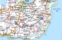 Richard Ellis walk: Day 2 at 13.5km (E) 2nd June - This is a fabulous start to the main walk, especially the first part from Zakros to Ziros across the high plains at about 700 to 800 m. The climb up out of Zakros on the old mule track (kalderimi) is gentle even if a bit broken and a bit overgrown in places. Distance:24.1 km Time: 8 hrs. 40 mins Mov av 4.4 km/hr Height overnight: 260 m.  Sitia, East Crete at 14.2km (NW) The village of Tourloti (GR: Τουρλωτή) is located in Eastern Crete, on the road from Agios Nikolaos to Sitia. Tourloti is 42 km from Agios Nikolaos and 27 Km from Sitia. Tourloti is a small, traditional village, the largest of a group of four, dotted across the hillsides in this area. It has changed little in the past few decades, and remains untouched by tourism. However, it retains a healthy vibrant Greek community, of families living and working in the local area. The village has a prominent church, primary school, two small mini-markets, a bakery, chemist, post office, two kafenions and one small traditional taverna. The narrow streets with white washed houses, flower filled alleyways, and glimpses of spectacular views, give the village a unique, timeless sense of tranquility, far removed from modern city life. It is the centre for several religious celebrations and festivals, especially over Easter and the summer months. 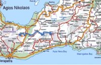 Richard Ellis walk: Day 4 at 14.3km (W) June 4th - There now followed two 30-plus kilometer days aggravated by the fact that I wanted to summit each range that I passed through - even though there is no strict E4 requirement to do this. So, I set off from Orino by 7.00 am on the clearly marked dirt road which is the pass through the mountains towards the village of Thripti. Distance:32.2 km Time: 11.5 hrs. Mov av 4.2 km/hr Height overnight: 330m.(max 1,476m.) 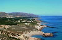 Sitia, East Crete at 15.6km (E) Xerókampos (GR: Ξερόκαμπος) is a beautiful coastal settlement in a place of natural beauty. The distance from Ziros is 20 km and from Zakros 11 km. The wonderful beaches, the healthy climate and the important ancient places of interest attract both Greek and foreign visitors. The settlement offers a infrastructure of small hotels, apartments, taverns, super markets and supporting facilities. Xerokampos is an old settlement. It is first recorded in the 1583 Venetian census. The ancients were certainly aware of the beauty of this place and its important position and the site has been inhabited since the Minoan times. The settlement would appear to have been at the spot called Katsounaki and on Trahilas hill a peak sanctuary already looted was discovered. There are important ancient sites from Hellenic times on the hills of Antisternia and Farmakokefalo. At Farmakokefalo where the excavations are under the authority of the archaeologist N. Papadakis an important town, mainly of the Hellenistic era was brought to light. It is possible that the town is Ambelos which various literary sources and correlation place in this area of Crete. Image Library
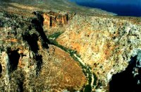 Zakros, Sitia, East Crete at 15.8km (E) Within a few distance from the town of Zakros, starts the Gorge, which ends at the bay of Kato Zakros, almost near the Palace area. This gorge is of outstanding beauty, with large caves in its walls. In those caves were discovered tombs dated to the Minoan period, and finds of great archaeological importance. That is the reason why the caves are named "The Caves of Dead" and the gorge "The Gorge of Dead". Because of its natural beauty and archaeological significance the gorge attracts numerous visitors every year. Image Library
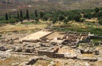 Sitia, East Crete at 17.3km (E) Like the other Cretan palaces, the palace of Zakros, was first built in about 1900 B.C. The present ruins seen by the visitor belong to the second building phase, in about 1600 BC. The total area of the palace, including ancillary buildings, is approximately 10,000 sq.m. It was not only the permanent residence of the royal family, but also the administrative, as well as commercial and religious centre of the surrounding area. The long term excavations have yielded over 10,000 objects, many of them considered unique, which are now on display in the Iraklion and Sitia museums. Image Library
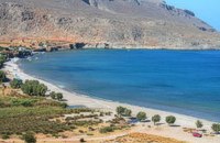 Kato Zakros at 17.5km (E) Small coastal village at the eastern edge of Crete. Here in 1961 a great Greek archaeoligist, N.Platon, unearthed the fourth largest Minoan Palace. Nowadays in Kato Zakros (GR: Κάτω Ζάκρος) live a few people, occuping with farming, and fishing. There are a few taverns and cafe bars available for the visitors as well as a few rooms for rent. The scenery is great and the sandy beach with crystal clear water is one of the nicest in eastern Crete. Apart from a visit to the Minoan site the visitors can take a walk through the imposing gorge of the dead or follow the path along the coast to the cave of Pelekita
Image Library
 Richard Ellis walk: Day 1 at 17.5km (E) The E4 path out of Zakros starts a short way south of Hotel Zakros on the main road and is signed up to the right along with signs for old water mills and the like. You have to poke about a bit in the upper levels of Zakros to be certain of being on the right path but upwards and westwards is the key. Distance:6.7 km Time: 1.5 hrs. Mov av 4.9 km/hr Height overnight: 225 m. 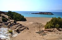 Sitia, East Crete at 17.8km (S) Koufonisi is a small island in the Libyan Sea just off the South East coast of Crete and the Cape of Goudouras. It is also named LEFKI and gave its name to the municipality. There is a cluster of small islets in the area like Makroulo, Strogylo, Trahila and Marmara. The island is deserted and in many spots it is covered with sand reminding an African landscape. Until 1976 the shepherds used to feed their sheep there but it was not inhabited. Later the Archaeological Offices of Eastern Crete under the authority of N. Papadakis began the excavations and the island proved to be full of ancient sites. A beautiful theater, made of stones, at the North West end of the island opposite the Marmaras islet was discovered. At the South East of the theater where a settlement was found, a villa with 8 rooms and a guest room was brought to light. The excavations also showed a workshop where the famous purple robes of the Romans was made. They also dig out an astonishing building, the Public Baths, dated back to 1st and 4th A.D. and ruins of an old temple. Boats depart daily from Makrygialos to Koufonissi (during the tourist season and only if the weather permits) offering day-trips. A short description of Lefki, by the archaeologist Nikos Papadakis: Koufonisi island covered today with sand and bushes, lies close to the southeast shore of Crete. From the Middle - Ages until today is nowhere referred that the island has ever been inhabited permanently. However scattered ancient remnants, drew the attention of the English admiral and traveller T B. Spratt in the mid - 19th century. His itinerary and visit was repeated by the English archaeologists Bosanquet and Curely in 1903 and by the American A. Leonard jr in 1970. The definite conclusion all the above travellers reached was that Koufonisi could be identified with the island Lefki of antiquity for which the people of Itanos and Hierapytna were contending as it is referred in the famous "Inscription of Magnetes" of 112 - 111 B.C. Excavations and archaeological research have since 1976 taken the responsibility to answer to the questions almost innate and consequent to the above conclusion and the result is undoubtedly impressive: An entire theater that could have housed a thousand spectators: a temple still containing fragments from the colossal cult statue: two private houses with 17 rooms decorated with mosaics and colourful walls: a system supplying water to the city through a series of vaulted cisterns and built pipes: a Minoan acropolis: cemeteries and last but not least the city of Lefki itself. Thus, slowly but steadily is unveiled the short but impressive presence of this small island nearby east Crete. Judging from the so far finds we can say that Lefki being one of the major centers of processing and trading purple, a symbol of authority and economic power soon became the object of rivalry among its neighbours. A series of diplomatic intrigue and fighting had occurred over the dominance of this prolific island. Later when its sources of prosperity were depleted the people of Lefki were exterminated through arms and fire: an invasion in the 4th century A.D. turned the historic island into ashes. On the basis of the existing ruins the importance it had for its neighbours and the fact that it was never again inhabited after its destruction we may describe Koufonisi by quoting a western journalist as Delos of the Libyan Sea.  Sitia, East Lassithi at 18.2km (NW) A small picturesque village by the sea characterized as a landscape of exquisite, natural beauty. With joyful and peaceful inhabitants who constantly tease each other. It is located in Crete, north of Lasithi prefecture, between Agios Nikolaos and Sitia, at equal distance (30-35km) from the three major cities(Agios Nikolaos, Sitia, Ierapetra). Ideal place for holiday or special weekends. You will enjoy the most colourful sunset and the most beautiful daybreak from any other place. The serenity of the morning open view, with the sun rising from the sea, will be unforgettable. The small island, opposite the village, with the small church of Agios Nikolaos, offers a unique beauty to the landscape. 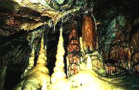 Zakros, Sitia, East Crete at 19km (E) The cave, with impressive stalagmites and stalactites, is located near the sea (~200m), at Pelekitá (GR: Πελεκητά), a place 3km away from the Palace of Zakros (~1 hour walk)and above the small bay of Karoumbi. In this cave were discovered signs of neolithic habitation. Its entrance is at 105m above sea, it is 310m long and its area is approximately 4.500m2. A little further there was found also the quarry from where the ancients took the stones to built their Palace (hence the name "Pelekita"). The cave is also known as "Sikias Spilios" (the fig tree's cave) due to the fig tree that is located at its entrance. The view to the sea from there is magnificent.
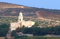 Sitia at 19.4km (NE) It is an historical monastery of the 15th century, which collapsed in the earthquake of 1612 and was rebuilt with the financial aid of the Venetians. During the Ottoman conquest of Crete, the monastery was destroyed and devastated by the Turks. In 1704 the monastery was declared stauropegion. During the Ottoman occupation there was a school in the monastery, while, after 1870, it was founded there a school of mutual teaching. The Monastery is a stauropegion fortress. The main building of 800 m2 has three floors, which are divided into cells, guest - houses, kitchens, the abbot' s residence and warehouses. The katholicon is a two-aisled church; the northern aisle is dedicated to the Virgin, and the southern posterior aisle, to St John the Theologian. The monastery' s characteristic bell tower bears relief crowns and crosses with inscriptions and the date 1558. In the Monastery, there is also an interesting Museum.
Image Library
 Sitia, East Lassithi at 20.4km (NE) Palekastro (Palaíkastro GR: Παλαίκαστρο) is a lively, unpretentious town, at the east coast of Crete 20 km. away from Sitia and the seat of the Municipality of Itanos. It was named after an old castle. Its sources main income is agriculture and tourism. Although the town is growing, it manages and retain its character and charm. The town's square is the center of activities and is lined with cafes and taverns. Many a pleasant hour can be passed here, watching the world go by. During the summer months, weddings are often held in the village, with the huge wedding feast taking place in the square, to which everyone is invited. A chance to try your hand at Cretan dancing! 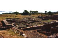 Sitia, East Lassithi at 21.8km (NE) At the northernmost edge of the eastern coast of Crete lie the ruins of a settlement which flourished during the Late Minoan period (1550-1220 B.C.). At the same site, however, are preserved remains of the Early and Middle Minoan periods (3000-1550 B.C.), mostly cemeteries with well-built ossuaries, and ruins of spacious houses. The site ceased to be inhabited at the same time when Zakros was abandoned (1450 B.C.) but was reoccupied during the Late Minoan III period (1300-1200 B.C.). The city covered a total area of more than 50,000 sq.m., was densely inhabited but not fortified. To the NE of one of the city's sectors lies the sanctuary of Diktaian Zeus, which belonged administratively to the city of Itanos. Cult practice was continuous from the Geometric period (8th century B.C.) until the Roman conquest. It seems that the sanctuary was plundered and destroyed by fanatic Christians at the end of the 4th century A.D. Image Library
Vassiliki - Archaeological Site Pahia Ammos, Ierapetra at 24.1km (W) The ancient settlement of Vasilike is one of the first Minoan settlements with town-planning. It occupies the top and slopes of a low hill near the village Vasilike, in the vicinity of the Minoan settlement of Gournia. The first settlement dates back to the Early Minoan II period (2600-2300 B.C.) and owed its development not only to the strategic position, controlling the Isthmus of Hierapetra, but also to the neighbouring fertile plains. The central building of the settlement was destroyed by fire in around 2300 B.C.  Pachia Ammos at 24.6km (W) The Institute for Aegean Prehistory Study Center for East Crete (or INSTAP-SCEC) is a unique facility for archaeological research, especially in the area of Aegean Prehistory. The Center is committed to stimulating and facilitating publication in the broader field of Cretan studies, with a focus on archaeology and ethnology.
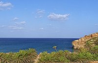 Sitia, East Lassithi at 25km (NE) A palm tree forest stretching on a marvelous valley and sandy beach. It consists of self planted palm trees of Theophrastus (Phoenix Theophrasti). It is unique of its kind in Greece, Europe and probably the world. Vai because of its special value and beauty is protected by the Greek state, European Union and international contracts. The protected area covers 23.4 ha. The sandy beach of Vai is amongst the most beautiful in Crete and Greece and attracts thousands of visitors every year since Vai is a top destinations especially for the new comers. The small islets opposite the beach add a lot to the beauty of the place. There is a parking area, a tavern, a canteen, umbrellas and seabeds. There is regular public bus connection with the towns of Sitia and Palaikastro during the summer and many organised day trips by travel agencies. If you don't like crowds, you can walk a little to the south from Vai to Psili Ammos a lovely small beach with fine gold sand which is nested in a small cove. Image Library
|
||
|
| ||


C
O
N
T
E
N
T
S
O
N
T
E
N
T
S