interkriti®
YOUR GATEWAY TO CRETE
HOME
CRETE FACTS
NAVIGATE
EXPLORE

Agia Galini
Triopetra
Kissamos
Chryssi Isl.
Agia Marina
Balos
Gavdos isl.
Georgioupolis
SAMARIA
IDA Mtn
Palaiochora
Agia Roumeli
Sfakaki
Bali
Kalamaki
Matala
Lassithi
Plateau Lendas
Tsoutsouros
Vianos
Myrtos
Sfakia
Plakias
Ierapetra
Makrygialos
ZAKROS
Vai
Sitia
Agios Nikolaos
Elounda
MALIA
Hersonissos
Gouves
Chania
Rethymnon
Heraklion
GORTYN
FESTOS
KNOSSOS
|
|
Crete
List Grid Map
Found
140
- Showing :
21 - 40
 Pediada, Iraklion at 12.5km (S) A beautiful small settlement, with 48 people, Epano Karouziana (GR: Επάνω Καρουζανά) lies at an altitude of 380m and is located at 40km from Herakleion. It is mentioned for the first time in 1842, its name was taken by a family name "Karouzos" common in the village. The village offers a spectacular view, picturesque paved lanes, traditional kafeneia and taverns and is a popular with tourists, especially in the summer when many Cretan evenings are organized with local music and dance.  Pediada, Iraklion at 12.8km (S) Apostoloi (GR: Αποστόλοι) is a village in the area of Kasteli, 360 m above sea level. It has about 490 inhabitants, and is located on the 32 km of the road leading to Kasteli in the NW part of Apostolianos Kampos, among vineyards and olive groves. Until recently tannery was a main activity among the villagers. The earliest reference to the name is to be found in a contract drawn in 1279, where Sancti Apostoli et Sophoro were lands belonging to the Venetian lord Leonardus Gradonicus, who gave them and leased them to Petro Quinino. There is another mention of the name in a document dated to 1378. It is also quoted by Fr. Barozzi in 1577 as forming part of the Pediada district. The name of the village finds its origins in the name of an old church dedicated to the Saint Apostles. The present church was built on the same site in the 19th century, in 1876. The church of Agios Giorgos is Byzantine and has wall paintings. According to village tradition, on the night of Easter in 1841, the Turks caught the Cretan leader of the revolution for the Eastern part of the island, Giorgos Vassilakis, or Vassilakogiorgi and hanged him from a fig tree.The village kapheneions serve particularly good raki and on June 29th there is a great feast in the honour of the Saint Apostles, Peter and Paul.  Iraklion ( Nea Alikarnassos) at 13.1km (W) Heraklion International Airport, "Nikos Kazantzakis" (Greek: Κρατικός Αερολιμένας Ηρακλείου, "Νίκος Καζαντζάκης") or Nikos Kazantzakis International Airport (IATA: HER, ICAO: LGIR) is the primary airport on the island of Crete, Greece. It is located about 5km from the main city of Heraklion. Heraklion International Airport is is one of the biggest in Greece and receives approximately 15% of the total tourist traffic of Greece. There are many airlines currently operating flights from Athens and Thessaloniki to Iraklion (Olympic Airways, Aegean Airlines and others), while during the high season there are flights from/to Rhodes, Mykonos, Santorini and other Greek islands. There are also international airlines that connects Iraklion to other European cities. During the summer season there are numerous chartered flights to Iraklion from all over Europe (mainly Germany, the United Kingdom, Russia, and Holland). During the summer months there is a huge increase in air traffic that peaks in August (approximately 130 flights per day). Major car-rental companies have desks at the airport. Taxi and public bus are available for transfer from/to Iraklion.  Iraklion at 13.4km (SW) The monastery of Agaráthou (GR: Μονή Αγκαράθου), dedicated to the Virgin, stands at an altitude of 538m, on "Soros Panteli", a rocky hill between the villages of Sgourokefali and Sabas, 23 km from Heraklion. During the period of Venetian rule it was a centre of learning, producing many famous churchmen including the Patriarchs Cyril Lucaris, Meletius Pegas and Sylvester the Cretan. The church was rebuilt in 1894 and flourished once more after the end of the Turkish occupation. Young, educated monks with university degrees have recently settled in the monastery, restoring it to its former glory.  Pediada, Iraklion at 13.7km (S) Polythéa (GR: Πολυθέα) is located 500 m NE of Kastelli at an altitude of 335m.N Nowadays Polythea has become part of Kasteli and it has 364 inhabitants. Fr. Barozzi mentions it as Apigaiduri in 1577, belonging to the Pediada district and it continues to be known with that name until 1940, when it is re-baptized with its current name, Polythea. The previous name of the village, Pigaidouri, is originated by the word ‘pigaidi', which is Cretan for ‘pigadi', which means ‘a well'. It is a nice name that propably has been changed due to the fact that people thought it was a reference to ‘gaidouri', which means ‘donkey'. Apart from the ubiquitous raki and mezedes served at the kapheneions, you can also find rooms for rent. A typical Cretan feast is held here on August 15th for the Virgin Mary (Assumption).  by Richard Ellis at 13.7km (S) 9th June- I rested for a day in the Kalliopi hotel, tended to my feet as best I could and tried to “carb-load” as instructed by my tri-athlete daughter...I made the decision to take as direct a route as I could towards Profitis Ilias in order to make my rendez-vous with Triantafyllos at Rouvas the following evening. This meant leaving the official E4 and bypassing Archanes and Ghiouktas and all the interesting historical stuff. Distance: 38.5 km Time: 11.5 hrs. Mov av 5 km/hr Height overnight: 175m.  Pediada, Iraklion at 13.9km (S) Kastelli (GR: Καστέλλι) is a small town in the countryside of the province of Pediada. It has over 2000 inhabitants and provides all the modern facilities and public services its residents and/or visitors may need. Many events are organized through the year by the municipality, the school and the cultural centre. In August a special festival, known as the Feast of Xenitemenou (ex-patriot feast) includes concerts, folklore, exhibitions and theatre plays.
 Pediada, North - East Iraklion at 14km (SE) The famous tourist resort with all types of accommodations. Great beaches and a lively party atmosphere particularly in August. Becomes pretty quiet and peaceful during the rest of the season and there is a nice and picturesque part of the old village that preserves the traditional character. Malia has also a significant agricultural production and is famous for its bananas, potatoes and bottled water.
 Pediada, Iraklion at 14.2km (SE) Askoi (GR: Ασκοί) is small village in the municipality of Kasteli has 315 inhabitants. It lies in the foothills of the Dikti mountain, 11 km to the east of Kasteli and 8 km from Lyttos. Fr. Barozzi mentions it as Ascus, in the Pediada district, in 1577. Recently a ritual clay figurine of the Mid-Minoan period was fortuitously unearthed on a peak close to the village. The remains of a large building belonging to a peak sanctuary have been excavated at Amygdalokefalo to the NE of the village. A reference in a contract of 1271, mentions how Petri Comarii from the village (casali) Maski owes Ruggerino Temisano, resident in Chandax, 25 «mistata» of good Cretan wine from his vineyards in Maski. Among other natural beauties, the ravine at Aski is well worth seeing. On December 4th the village has a typical Cretan feast to honour Agia Varvara. And as in every Cretan village, raki and ‘mezedes’ are always available at the kafeneions. Image Library
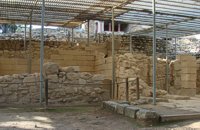
 Pediada, Iraklion at 14.5km (S) Diavaide (GR: Διαβαϊδέ) has 120 inhabitants and lies very near to Kasteli (700m to the SE) at 355m above sea level. The earliest reference to the name is found in the Ducal Archives at Chandax in 1378. Another document in the same archives mentions a certain G. Dochiano, inhabitant of Diavaide. In an inscription, found in the Byzantine church of Agios Georgios Sfakiotis, the name of the village is clearly mentioned, indicating that Diavaide existed well before the Turkish occupation. In that church there is a unique fresco of Byzantine art that represents Saint George and Saint Demeter passing through the sea on their horses, while at their feet lie various sea creatures; crabs, lobsters, and other fish, a strange phenomenon indeed, considering that the village is so far away from the sea. There is also the church of Agios Nikolaos in the village dated to the same period. The village took part in all the main fights by Crete against the enemies of its freedom, while during German occupation the high college of Kastelli continued to operate in Diavaide houses. The cultural association of the village, one of the first in this area, strives to maintain the cultural traditions and the continuity of village history through the years.  Kasteli, Pediados at 14.6km (S) The ancient city of Lyktos or Lyttos (GR: Λύκτος / Λύττος) was one of the most ancient and powerful towns in Crete. Although the excavations in the area reveal traces of habitation from the Hellenistic years onwards (630 B.C.), the archeologists Georgios Rethemiotakis and Angeliki Lempesi have excavated traces of habitation from the time of the destruction of Lyttos by the Knossians (219 B.C.) in excavated residences of the Hellenistic period. From the Roman period, the city was subject to new workings as testified by the architectural remnants and the many inscriptions and statues discovered. Numerous vestiges of ancient structures, objects, and broken marbles are seen, as well as an immense arch of a Roman aqueduct, by which the water was carried across a deep valley by means of a wide marble channel. Traces of the aqueduct which brought its water supply from Kournia, near Krasi village, are still visible today in the rural road to Kastamonitsa village. Lyktos had also a theatre, built in the slope of the hill the design of which we know only from the drawings of Belli (1586). Finally, the most important discovery is that of a room of nearly 14 metres by 11.40 metres, with marble flooring and a series of four stone platforms along its two longer sides. The room was erected, according to the inscription that was found at the site, at the beginning of the second century B.C. This room was identified as the chamber of the Roman deputies of the city and was very probably destroyed by an earthquake at 365 AD. Lyktos appears to have still been inhabited in the 7th Century AD as indicated by the excavation of late-roman shops in the area. (Late Roman Empire, 284-610 AD)  Pediada, Iraklion at 14.6km (S) 330 m above sea level, just out of Kasteli (1.5 km) to the east, lies the village of Archangelos (GR: Αρχάγγελος) with 433 residents. It was founded in 961 by the military forces of Nikiphoros Phocas and was originally named ‘Varvaro’, and was still known by that name in 1583, where the Chandax Register puts it down as a village of the Pediada district with 37 inhabitants. Its name was changed only recently, in 1961, to Archangelos, and the main village church in the square is dedicated to the Archangel Michael. There is another smaller and older church, that of the Panaghia, with Byzantine wall paintings. Remains of ancient mills can still be seen. In a location known as Trochalos, archaeological finds have brought to light a series of Minoan tools dating back to the first and second Late Minoan periods. As in every Cretan village, raki and ‘mezedes’ are always available at the kapheneions. The feast of Michail Archangelos on November 8th is celebrated with much feasting in the village. 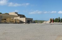 Knossos Palace at 14.6km (S) The Central Court (dimensions ca. 50m x 25 m.) is an architectural element common to all Minoan palaces. The Court connects the different wings with one another. There was also direct access from outside the Palace. Part of the paving, which once covered the whole court, is preserved in the northwest and southwest corners, whilst near the "Throne Room", parts of the drainage system can be made out which ensured the evacuation of rain water. It is thought that the area must have been for meetings and rituals of both a sacred and profane character The orientation of the Central Court was north-south with a clear view of the sacred Mount Giouhtas, where an important sanctuary was located. Image Library
 Knossos Palace at 14.6km (S) A large part of the east wing cannot be seen from the Central Court as it is built into the side of the hill on top of which lies the rest of the Palace. It is one of the most interesting parts of the palace because two storeys are preserved below the level of the Central Court. Today, a large part of it has been reconstructed in concrete. The storeys are connected with one another by means of a system of stairs known as the "Grand Staircase". The staircase was found during the excavation in its original position. There is a total of four flights of stairs, two for each storey. The two lower flights are preserved as they were found. The steps are broad and deep, with a gentle incline that makes for an easy ascent. The staircase is lit by a large light-well and was surrounded by a colonnade of wooden columns. The Grand Staircase The Grand Staircase The Grand Staircase & Hall of Colonades - First floor The Grand Staircase & Hall of Colonades - Ground floor A series of corridors, spacious halls and small rooms is connected to the Grand Staircase. Evans, who believed that the Palace was the seat of the king of Knossos, hypnothesized that the residential quarters of the Royal family lay in this part of the site. 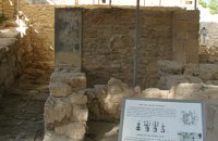 Knossos Palace at 14.6km (S) This room lies at the southern part of east wing in an area with many small rooms (possibly storerooms and magazines), lustral basins and light-wells. It was made into a shrine at the end of the Postpalatial period (1375-1200 B.C.). It is known as the "Shrine of the Double Axes". On a bench at the back, different ritual objects were found amongst which were a stone double axe and votive clay idols - among them the terracotta figurine of a goddess with upraised arms. Similar small shrines have been found in houses of the same period.
Image Library
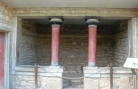 Knossos Palace at 14.6km (S) This house belongs to the New Palace Period (1700-1450 B.C.) and was functionally related to the Palace. In its restored part with two columns, there was a bench on which some object of worship had probably been set up. There was a paved hall in front with a double pier - and - door partition.
Image Library
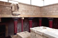
 Knossos Palace at 14.6km (S) The south-east house belongs to the New Palace period (1700-1450 B.C.). It was well built and decorated with wall-paintings of lillies. It had a pier-and-door partition, a pillar room and storage rooms. A little behind it are other houses of the Old Palace period (1900-1700 B.C.) such as the house of the "Sacrificed Oxen", named after the remains of a sacrifice found there (horns of a bull and a tripod table of offerings) and the "House of the Fallen Blocks", after the blocks that had fallen from the facade of the palace due to an earthquake. Next to "South-East House" there are houses of the Old Palace period (1900-1700 B.C.), such as that of the "Monolithic Pillars" in front of the steps. Under the small roof is a Minoan, possibly smelting kiln. 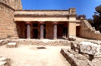 Knossos Palace at 14.6km (S) The "Hall of the Double Axes" was so named by Evans due to the double axe signs engraved on the walls of the light-well at its rear. He also thought that it was the place of residence of the King of Knossos. The central area has openings on three sides and is therefore called a "polythyron" (system with multiple doorways). It has a slab floor and its walls were embellished with gypsum slabs and frescoes. The area between the "polythyron" and the light-well was used as a reception hall. Traces of a wooden construction were found here. Evans reconstructed a wooden throne at this spot. Pictures: 1, 2 According to the archaeological finds, the arrangement of the apartments on the upper floor was similar to those on the ground floor. Image Library
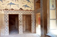 Knossos Palace at 14.6km (S) The Queen's Megaron lies in the Royal Apartments next to the "Hall of the Double Axes". It is a smaller room with a similar layout and rich decoration. Evans thought that it must have belonged to the Queen. Fragments of frescoes with dolphins and dancing ladies were found here. The room is largely restored and copies of the wall paintings have been put up on the walls. At the end of the room, a low partition wall with one column created a small space. It was thought that it was the "Queen's Bathroom" since pieces of a clay "bath" were found there. Pictures: The Queen's Hall 1, 2,3 A corridor joins the "Queens Megaron" with rooms that have been interpreted as places of preparation and washing. 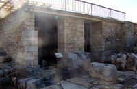 Knossos Palace at 14.6km (S) The magazine to the north of the Grand staircase took its name from the pithoi (large storage jars) that were found here. The jars have relief disk and rope decoration, a characteristic of the beginning of the New palace period (1700-1450 B.C.). A variety of finds show that the place had also been used as a magazine in the Old Palace period (1900-1700 B.C.). Next door is the "Corridor of the Bays", where three small openings were used for storage. Many vases and religious artefacts were found here. The magazines were buried at the end of the New Palace period(1700-1459 B.C.). Image Library
|
||
|
| ||


;)
;)
;)
;)
;)
;)
;)
;)
;)
C
O
N
T
E
N
T
S
O
N
T
E
N
T
S