interkriti®
YOUR GATEWAY TO CRETE
HOME
CRETE FACTS
NAVIGATE
EXPLORE

Agia Galini
Triopetra
Kissamos
Chryssi Isl.
Agia Marina
Balos
Gavdos isl.
Georgioupolis
SAMARIA
IDA Mtn
Palaiochora
Agia Roumeli
Sfakaki
Bali
Kalamaki
Matala
Lassithi
Plateau Lendas
Tsoutsouros
Vianos
Myrtos
Sfakia
Plakias
Ierapetra
Makrygialos
ZAKROS
Vai
Sitia
Agios Nikolaos
Elounda
MALIA
Hersonissos
Gouves
Chania
Rethymnon
Heraklion
GORTYN
FESTOS
KNOSSOS
|
|
Crete
: Regional Interest
List Grid Map
Found
29
- Showing :
21 - 29
 Sfakia, South Hania at 24.8km (S) The Samaria Gorge is one of the longest ravines in Europe (with a total length of 16 km) and offers one of the most spectacular hiking routes in Europe. Its width ranges from 150 m (widest part) to 3 m (narrowest part). The walk from Xyloskalo in the plateau of Omalos to the shores of Libyan sea at Agia Roumeli, takes 6 to 8 hours. The Samaria Gorge has been designated as a national park in order to protect its flora and fauna. It is one of the last shelters of the mountain goat of Crete (Cretan Ibex, common name : kri-kri). The flora is extensive, ranging from high cypress trees to flowers and herbs. The walking path follows the river which flows to small lakes and waterfalls. The Gorge is open to visitors from May to October. Image Library
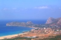
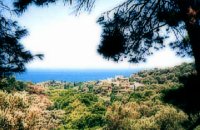
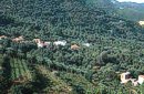 Kissamos, Hania at 24.9km (SW) Vlatos is located at 380m a.s.l., 54 km away from Hania and 18 km from Kastelli Kissamou. It is built in a tree covered valley, with olive trees, chestnut trees and wild vegetation. There are some very nice trekking paths around and in the forest of "Peace" which has been characterized as a natural park. The "Park of Peace" was founded in 1970 by the Cultural Association of Vlatos with the cooparation of Goethe Institute and the support of the Bavarian Department of Forests. It is an experimental park with 150 species of plants, covers an area of 1,000,000 sq.m. and is part of an extended area of 20 sq.km. which have been reforested.  Kissamos west coast at 25.4km (W) Platanos (GR: Πλάτανος = plane-tree) is located 10 km from Kasteli Kissamos. It is a large village, the second largest in Kissamos area, after Kasteli. It has approximately 1000 inhabidants, which are occupied mainly in green house and olive cultivation and tourism. There is a doctor's office, gas stations, many shops, rooms for rent and taverns. At the village's old square stand a plane-tree with a fountain.  Selino, Hania at 26.5km (S) Elyros ("Έλυρος" in Greek) is an ancient city, located in southwest Crete, in Kefala Hill, near the village Rodovani and is presently unexcavated. Elyros was flourishing at least as early as the Greek Classical Period, e.g. 500 to 350 BC. In the Classical Period Elyros was the most important ancient city in southwestern Crete, having about 16,000 inhabitants. It was an industrial and commercial city with large weapons production. Syia and Lissos were its harbours. Apollo, Phylakides and Philandros, sons of Apollo and nymph Akakallida, were worshiped there. In the third century BC Elyros was at war with Kydonia, an important center of Cretan power, located in the modern city of Chania. The citizens of Elyros sent to the Delphi Oracle, a bronze votive complex that represents a goat feeding the sons of Apollo when they were infants. It is also one of the thirty cities that signed the decree with Eumenes B’ in 183 BC.Elyros was also important during Roman times. A Roman statue, the Philosopher of Elyros was recovered here and is now in the Archaeological Museum of Chania. During Byzantine times, Elyros was the seat of an Archbishop and the remains of the bishopric church, a sixth century basilica, can still be seen in the centre of the old city. Robert Pashley was the first who identified the location of the city, near village Rodovani. Thenon studied more carefully the ruins of the city and discovered the inscription that says: “it seemed to the city of the Elyrians”. The output of its mint consists of silver drachms from the 3rd c. BC, which depict a wild goat and a bee; in addition to their function as religious symbols, these undoubtedly hint at the stock-raising activities in the region, particularly to this kind of wild goat, which can still be found in great numbers on the island. The bee also has reference to the abundant honey-production of Crete. 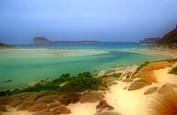 Gramvoussa Cape, Kissamos at 27km (W) West of Kissamos and north of the beautiful village of Kaliviani, stretches the impressive Gramvoussa peninsula. The peninsula is formed by steep rocks and is covered with thyme and origanum bushes and wild flowers. On the north west side of the peninsula opposite to the island of Gramvoussa is the wonderful beach of Balos (GR: Μπάλος). The beach is covered with fine white sand and is located between the two creeks of the Tigani cape. The same white sand covers the bottom of the sea and grants to the sea an emerald color. In front of the beach is the picturesque island of Gramvoussa and on the back is the Geroskinos mountain (altitude 762 m). The road from Kaliviani is well paved dirt road, with amazing view to the steep rocky seaside of the east side of the peninsula. The road ends one-two km before the beach, and the visitor can follow a paved road to Balos. North of Balos, at the Korykon cape, are the ruins of the small Roman city of Agnion, with a temple of the God Apollo. There are small boats, offering daily cruises to Balos and Gramvoussa, departing from Kissamos (Kastelli) during the summertime. Image Library
 Kissamos, Hania west coast at 27.1km (W) Falássarna (GR: Φαλάσαρνα)is a quiet resort, with small hotels, apartments and taverns, close to the wonderful sandy beach. There are also many spots for free camping. Falassarna used to be the port of ancient Polyrinia. The peak of the city of Falassarna was during the Hellenistic period and at the time the city had its own coin. Its port was closed and surrounded by walls and it was connected to the sea with a canal.
Image Library
 Apokoronas at 27.8km (E) A flourishing traditional seaside town on the Apokoronas Peninsula 17km east of Hania. Kalýves (or Kalives GR: Καλύβες) with its old tiled stone houses, mixed with the latest buildings form two separate districts, with typical island style. Most of it is literally built on the sea and has 1289 residents. Xydás (GR: Ξυδάς) river that runs through the town, is giving it a unique character and a cool climate that prevents the heat of summer. In the square, you will see a traditional water mill built in the early 20th century, one of the oldest in the area. Kalives is tastefully developed for tourism, and welcomes many visitors during the summer season to its safe sandy beach. With comprehensive amenities, there are many shops, taverns and kafeneion, in addition to banking, post office and petrol station facilities.
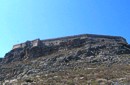 Gramvoussa Cape, Kisssamos at 28.6km (W) Due to its strategic location, Gramvoussa was fortified by the Venetians, who built a well-fortified castle on the top of a steepy rock at an altitude of 137 m. Construction on the castle of Gramvoussa started in 1579 and ended in 1582.
 Kissamos west coast at 29.8km (W) The village of Sfinari is blessed with many water sources so it is overwhelmed with trees and flowers. Fresh fish is guaranteed as it abounds in the sea around the village, dolphins are often seen in the sea. To the rocks near the beautiful beach of Sfinari come the seals to give birth to their babes. The village offers many rooms for accommodation and there are taverns in the village and by the beach in the trees that cover the sea side.
Image Library
|

|
|
|
| ||

C
O
N
T
E
N
T
S
O
N
T
E
N
T
S