interkriti®
YOUR GATEWAY TO CRETE
HOME
CRETE FACTS
NAVIGATE
EXPLORE

Agia Galini
Triopetra
Kissamos
Chryssi Isl.
Agia Marina
Balos
Gavdos isl.
Georgioupolis
SAMARIA
IDA Mtn
Palaiochora
Agia Roumeli
Sfakaki
Bali
Kalamaki
Matala
Lassithi
Plateau Lendas
Tsoutsouros
Vianos
Myrtos
Sfakia
Plakias
Ierapetra
Makrygialos
ZAKROS
Vai
Sitia
Agios Nikolaos
Elounda
MALIA
Hersonissos
Gouves
Chania
Rethymnon
Heraklion
GORTYN
FESTOS
KNOSSOS
|
|
Crete
List Grid Map
Found
72
- Showing :
41 - 60
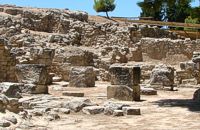 Phaistos Palace at 19.1km (NW) The complex of four rooms on the northeast edge of the Palace does not belong to the Old Palace, although it directly adjoins it. In the westernmost building is an elongated rectangular room with partitions of vertical clay slabs. Similar "cists" in the Palaces of Knossos and Zakros were used to store valuable ritual vessels. Here they were found empty. Next door, in the narrow rectangular room to the southeast, was found a clay tablet inscribed in Linear A and the famous "Phaistos Disc" bearing hieroglyphic writing. The building was therefore named the Palace "Archive" The building east of the Archive is thought to be a shrine or the archivist's residence, while the easternmost building is known as the "Potter's Workshop" because a large number of unfinished pots were found there. The intermediate building has an impressive peristyle of alternating pillars and columns. A staircase on the south side of the peristyle building connects the whole complex to the NE entrance to the Palace, which stood in this spot. Image Library
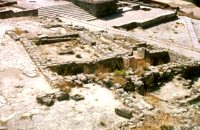
 Phaistos Palace at 19.1km (NW) The east part of the North Wing forms the workshop area of the Palace. It consists of the East Court and a complex of small rooms which are believed to be the workshops of the New Palace (1700-1450 BC). Approximately in the centre of the court are the ruins of a horseshoe-shaped kiln. The elongated rectangular building with 6 rooms on the west side of the court appears to have been used for the workshops of the kiln craftsmen. The square room on the north side of the court was the gatehouse of the northeast entrance to the Palace. It has gypsum slab flooring and benches around the walls. Behind it is a long corridor leading to the inner courtyard of the North Wing and thence to the "Royal Apartments" Image Library
 Found at Phaistos Palace at 19.2km (NW) The disc of Phaistos is the most important example of hieroglyphic inscription from Crete and was discovered around 1903-05 in a small room near the depositories of the "archive chamber", in the north - east apartments of the palace, together with a Linear A tablet and pottery dated to the beginning of the Neo-palatial period (1700- 1600 B.C.). The disc of Phaistos can be seen at the Archaeological Museum of Heraklion. Image Library
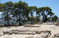
 Phaistos Palace at 19.2km (NW) The Upper Court is the first of the three courts in the West Wing of the Palace. Its south side is supported by a strong retaining wall separating it from the West Court. On the west side, the 17 circular recesses in the ground indicate the presence of an equal number of wooden columns which probably supported a covered colonnade. The court is crossed from north to south by a raised "Processional Causeway", which, like those of the other palaces, would have been used for sacred processions and other rituals. The Upper Court also functioned as a kind of balcony from which one could watch the events taking place in the West Court, which is just to the south and on a lower level. The two courts are linked by a majestic staircase starting in the southeast part of the Court. The buildings on the south side of the court were built much later, in Hellenistic times (323-67 BC), when the palaces had already beendestroyed. The most important of these contains a room with two columns, a central hearth and stone benches around the walls. It isbelieved to be a public building, probably a Prytaneion or Andreion.Early Christian tombs (330-600 AD) can be seen east of the "Processional Causeway" Image Library
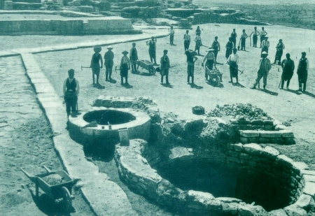
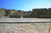 Phaistos Palace at 19.2km (NW) The large paved West Court, in front of the facade and the central entrance to the Palace complex, dates from the time of the Old Palace (1900 - 1700 BC) and played an important part in the lives of its inhabitants. On the north it is bounded by a high which also supports the Upper Court, which is on a higher level. At the foot of the wall are eight wide steps which formed the seats of what may be called a theatral area. As with the corresponding "Theatre" of Knossos, from here spectators would have watched the religious events and festivals taking place in the court. The West Court is crossed by a raised "Processional Causeway" similar to that of the Upper Court, which continues up the steps of the Theatral Area. During the time of New Palate the West Court was widened and raised to a higher level, so only 4 of its 8 steps remained visible. After the reduction of the Theatral Area, the great staircase must have been used as an additional theatral area for the events and ceremonies held in the West Court. 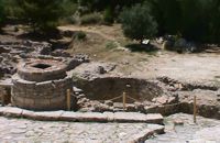 Phaistos Palace at 19.2km (NW) The south end of the West Court is occupied by four large stone-built structures known as "Kouloures" (rings) ,belonging to the Old Palace complex. The workmen on Evans' excavation gave them their name when they were first discovered at Knossos. Similar pits were also later discovered at the Palace of Malia. Their exact use is unknoun, although today they are generally regarded as depositories for offerings from the Palace shrines, or granaries. In front of the Phaistos "Kouloures" passes a "Processional Causeway" which starts in the West Court. One of the "Kouloures" is cut across by a cobbled road built in later years. The well next to them belongs to the Hellenistic period (323 - 67 BC).
 Messara, Iraklion South at 19.4km (NW) Kamilari is a quiet, traditional village, with a panoramic view to the endless olive groves of the Messara valley on the one side, and to the Libyan sea on the other side. It has been inhabited since the Minoan period. One of the seven wise men of the ancient world, Epimenidis, a great wise man and a soothsayer, lived in a small community outside Kamilari, called Metohi.
 Phaistos Palace at 19.4km (NW) The church of Agios Georgios (St. George GR: Αγιος Γεώργιος) Phalandras stands a little to the south from the Palace of Phaistos on the road to Agios Ioannis village. The church was the monastery church of the Orthodox male monastery of the same name, dated to the early Venetian period (16th century), which operated normally until its dissolution in 1821. The ruins of the fortified building complex around the church were still visible until the first decades of the 20th century. Image Library
 Matala, South - West Iraklion at 20.3km (W) The Red beach is located around 700m south from Matala. It is a beautiful secluded beach with fine reddish sand originating from the rocks of the area. The name "Red Beach" is given by the visitors due to its reddish color while its original name is Ammoúdia (GR: Αμμούδια). The sea gets a lovely blue-green color, making the landscape really unique. The only way to access Red Beach is on foot or by boat from Matala. The walk from Matala takes about 20 minutes and it can't be considered as an easy one. Red Beach however can get pretty crowded in the high season. There is a small stone-wall canteen offering snacks and drinks and a few umbrellas and sun-beds. Nudism is tolerated at the two ends of the beach. Image Library
 Messara, South - West Iraklion at 20.4km (W) Matala (GR: Μάταλα) was the ancient port of Phaistos and Gortys and a former fishing community which has developed into a modern holiday center. It is located 4 km south-west of the village of Pitsidia and 75 km from Iraklion. It is built on the coast line of the Messara bay inside a small and picturesque inlet. During the 60's the caves of Matala were hosting a hippie commune.
 Matala at 20.4km (W) We at Die Zwei Brueder (The Two Brothers) offer you nice, clean rooms. Although it's only two minutes walk to the beach or to the village, the pension's unique high placing guarantees you peace whenever you want it. Also help with information and car rentals to our customers. Find also villas for rent in the area. Villas Panorama and Peristeri are situated in the village of Pitsidia very close to Matala, Kommos and Kalamaki. They offer high standards' accommodation and one has its own swimming pool.  Messara, Iraklion South at 20.4km (NW) Vori is a beautiful, traditional village of the county of Pirgiotissas in the Messara Valley. It is located 60 km south of Iraklion and in the western part of the Messara Valley. The village stretches in a slope, by the side of a small river. The archaeological site of Phaistos is 2 km to the south and the coast of Messara 4 km to the west.
 Messara Bay, Iraklion at 20.5km (NW) One of the most beautiful sandy beaches of Crete, extends from a clump of rocks riveted in the shallow waters in the south to the Kalamaki settlement in the North. In Minoan times there used to be the ancient port of Phaistos. The antiquities lie just a few meters away from the sea.
Image Library
 Voroi, Messara, Iraklion at 20.7km (NW) The exhibited objects in the Museum come from all over Crete. These objects show that the folk culture of Crete is characterized by an amalgam of influences in which Minoan (2000-1000 BC), Archaic (1000-500 BC) and Byzantine models prevail, especially in agriculture, stock breeding, pottery and basketry.
 Archaeological Site in Messara, S-W Iraklion at 21.1km (NW) The "Royal Villa" at Ayia Triada which is situated very close to Phaistos, was built in about 1550 BC. i.e. just before the new palace at Phaistos, and was destroyed by fire in l450 BC, like all other important Minoan centres. It succeeded the first palace at Phaistos as the economic and administrative centre of the regions depriving the new palace there of this role, and appears to have had connections with Knossos. The two wings, with an open-air space between them, consisted of groups of interconnecting rooms (polythyra), storerooms and stairways. On the site of the ruins, a Mycenaean megaron, the so-called "Agora" and an open - air shrine were subsequently built. In the villa's disaster layer from the fire in 1450 BC, excavation revealed a valuable group of exceptional works of art, precious materials, records in Minoan script and seals. The famous black serpentine vessels, the "Harvesters' Vase", the "Boxers' Vase" and the "Chieftain ‘ s Cup", the wall paintings depicting the natural landscape, the sarcophagus, the bronze and clay figurines of worshipers and the copper ingots from the Treasury are among the most noteworthy findings.  Kenourgiou, Iraklion at 21.1km (N) Moúlia (GR: Μούλια) is a village in Kenouriou county, located three and a half kilometers away from Agia Varvara town and 32 km from Iraklion at an altitude of 640 m above sea level. Moulia is an old village as we come across a reference to it in a document dated in 1248, where the settlement is recorded as belonging to the archbishopric of Crete. Another reference is found in a legal agreement established in 1411. The name figures in all the Venetian censi of the 16th and 17th centuries, as well as in the Turkish and Egyptian censi. In 1881, it forms part of the municipality of Zaros with about 180 inhabitants, and again in 1900. As of 1920 it is a commune in its own right, and today with the lower village of Kato Moulia it counts over 550 inhabitants. The main church of the village, with wall paintings, is that of the patron saints, Saints Peter and Paul, and there is a village feast on the 29th June, in their honour. The lovely chapel of Zoodochos Pigis is also well worth a visit.
 Messara bay, Iraklion South at 21.5km (NW) A small coastal village with a long sandy beach is becoming very popular with tourists due both its natural beauty and its proximity to Phaistos, Gortys and other important sites. There are quite few hotels, apartments etc and taverns, cafes by the beach.
 Kenouriou, South Iraklion at 23.3km (N) Zaros (Greek: Ζαρός), at an altitude of 340 metres, is a town with a lake and gorge nearby. It has a couple of hotels and it is 44 km from Heraklion at the southern foothills of Mountain Psiloritis. The population of 3,400, produce olive oil, sultanas, vegetables and spring water. There are a couple of fish farms that serve both trout and salmon. In Zaros, there are cafes near Lake Votomos, as well as a tavern that serves fresh trout called I Limni (The Lake). Close by is Rouvas Gorge, which is part of the Psiloritis mountain range and is on the hiking route known as the E4 European Walking Path. Nearby Zaros are traditional water mills which have been working since the 16th century, as well as archaeological sites and monasteries. Zaros is also famous for its water "ZAROS" bottled by a company called Votomos SA.  Kenouriou, Iraklion at 23.5km (N) Megali Vrissi (GR: Μεγάλη Βρύση) lies 32km south of Heraklion, at 620 m above sea level. In the Barozzi document of 1577, it is mentioned as forming part of the province of Monofatsi and, in the Archives of Megalo Kastro (Heraklion), it is quoted in 1583 as having 71 inhabitants; there is also a reference to the village in the Basilicata document of 1630. The Turkish census records it with 47 families in 1671, and in the Egyptian one in 1834, it figures with 27 families. In the censi of 1881 and 1900 it is mentioned as a municipality in its own right with, respectively, 240 inhabitants and 307 inhabitants. As of 1928, it becomes a commune and today it counts over 900 inhabitants. Saint Constantine is the patron saint of the village. The churches of Aghia Anna and of the Panagia Almiri are worth visiting. The Aeolian Park, one of the islands pioneering projects, has been installed in Megali Vrisi and produces electricity of 5MW.  Messara, Iraklion South at 23.7km (NW) The town of Timpaki (GR: Τυμπάκι) is located in the west edge of the plain of Messara, 65.3km away from the city of Iraklion. It is a rich and busy town with significant economic activity especially due to the early vegetables production in the wider area. There are banks, a post office, medical centers, stores, schools, hotels, restaurants, ect to cover both the needs of the locals and visitors.
|
|||
|
| |||


)
)
)
)
)
C
O
N
T
E
N
T
S
O
N
T
E
N
T
S