interkriti®
YOUR GATEWAY TO CRETE
HOME
CRETE FACTS
NAVIGATE
EXPLORE

Agia Galini
Triopetra
Kissamos
Chryssi Isl.
Agia Marina
Balos
Gavdos isl.
Georgioupolis
SAMARIA
IDA Mtn
Palaiochora
Agia Roumeli
Sfakaki
Bali
Kalamaki
Matala
Lassithi
Plateau Lendas
Tsoutsouros
Vianos
Myrtos
Sfakia
Plakias
Ierapetra
Makrygialos
ZAKROS
Vai
Sitia
Agios Nikolaos
Elounda
MALIA
Hersonissos
Gouves
Chania
Rethymnon
Heraklion
GORTYN
FESTOS
KNOSSOS
|
|
Crete
List Grid Map
Found
144
- Showing :
41 - 60
 Pediada, Iraklion at 14.9km (SW) At an altitude of 380m, with 63 inhabitants, Liliano (GR: Λιλιανό) is first mentioned in the Turkish census of 1671. The Basilica with its three naves, dedicated to Saint John, was built in the 12th -13th centuries and is one of the oldest and the most interesting in Crete. The stones used in its construction came from earlier buildings. The three naves, with the middle nave higher than the other two, are supported by columns in Ionic style. The narthex in front is lower with wider arches, whereas the door and windows have pointed arches.  Pediada, Iraklion at 15.8km (SW) Armacha (GR: Αρμάχα) lies at 490 m above sea level, at a distance of 7km from Kastelli, with 110 residents (census 2001) and is first referred to by Barozzi in 1577. Armacha is rich in the production of agricultural and livestock products. The Metropolitan Bishop, Tirnovos Voulgaria Ilarionas Kabanaris Sinitis was born, and is also buried here. A man of advanced learning, he wanted to translate the Bible to Demotic Greek.  Pediada, Iraklion at 15.9km (SW) Evangelismos (GR: Ευαγγελισμός) at 360 m above sea level, with 365 inhabitants, lies to the SW of Kasteli, distant only 5 km from the county town and about 35 km from Heraklion. In earlier years, the village was called Mouktari or Mouchtari and its name figures in a 1381 contract for the buying and selling of grain. The Byzantine church of the Panagia is worth a visit. On August 6th the village celebrates the feast of the Metamorphosis. Evangelismos is the seat of the newly (2010) created municipality, according to the National "Kallikratis Project", by uniting the former municipalities of Kastelli, Thrapsano and Akalochori. The name of the new municipality is "Minoa Pediada"  Pediada, Iraklion at 16.1km (SW) Village of the area of Kastelli with 115 residents, Agia Paraskevi is situated 5 km northeast of Kastelli at an altitude of 400m. It is first mentioned in the Turkish census of 1671 as Agia Paraskevi tou Xourdou with 17 haratsia (head tax). It is very possible that Santa Venerata, a village mentioned in 1463 by Cardinal Bissarion, is the name by which Agia Paraskevi was known at that period.  North - East Iraklion at 16.3km (W) Kokkíni Cháni (Kokkíni Háni - GR: Κοκκίνη Χάνι) is a beach resort located 14km east of the city of Heraklion, on the old national road from Heraklion to Agios Nikolaos. The beach from Vatheianos Kambos, to the west, to Gournes, to the east, is protected by small piers that in some places form small lagoons. It has fine sand and it is clean and well cared, with umbrellas and sun chairs, lifeguards and sea sports. The central street is lined with taverns, restaurants, bars, shops etc while the seaside street is less busy and ideal for walking. Image Library
 Mirabello, Lassithi at 16.6km (E) Neapolis is located 15 km westwards of Agios Nikolaos on the way to Heraklion from where it is roughly 50 km far. Neapolis is built in the green valley of Mirabello. In the period of the Venetian domination its two settlements were named "New Village". But when the seat of the Prefecture was transferred from Fourni to the “New Village” this last was renamed to Neapolis. Neapolis was maintained as the capital of the prefecture of Lasithi till 1904. After that date Agios Nikolaos became the new capital.  Nirou Chani, North - East Iraklion at 16.7km (W) A Luxurious, two-storey house, built of large ashlar. The walls were strengthened by timber-frames and covered with a thick layer of plaster and marble slabs. The building has a paved courtyard, a shrine, storerooms for agricultural products, a staircase, and rooms with benches. It has been interpreted as a High Priest's house, due to the numerous ceremonial vessels it contained. The house was probably built in the 16th century. C. (MM III period) and, after its destruction by fire in the 15th century BC (LM IB period), was finally abandoned. The "Minoan Megaron" at Nirou was excavated in 1918 by St. Xanthoudides. In 1960, under the supervision of the Ephor of Antiquities N. Platon, the site was fenced and the building restored. The monument is consolidated and cleared at intervals by the 23rd Ephorate. Visiting Hours: Daily: 8:30-15:00, Monday: closed Entrance Fee:Free Admission  Pediada, Iraklion at 17.1km (SW) Geraki (GR: Γεράκι). This lovely village of 375 inhabitants is located on the western slopes of the Lassithi mountains between the peaks of Afendi (1578 m) and Sarakinos (1588 m) in a beautiful glen, 520m above sea level and only 9km SE of Kastelli. It features an interesting Byzantine church, dedicated to the Archangel Michael (Archangelos Michail) with wall paintings that have not been maintained and some interesting (movable) icons by the local painter, Sepis. The active cultural centre of Geraki organizes many events during the summer season. Twice a year the village has a typical Cretan feast in honour of its patron saints: Agia Paraskevi on July 26th and Michail Archangelos on 8th November. The village produces agricultural products and great cheese that led to a specific cheese celebration. From Geraki you can also reach the lovely chapel of Agia Anna, driving through a particularly beautiful landscape with a spectacular view over the Geraki glen and fresh running water, a place ideal for a picnic. Image Library
 Iraklion at 17.9km (SW) The monastery of Agaráthou (GR: Μονή Αγκαράθου), dedicated to the Virgin, stands at an altitude of 538m, on "Soros Panteli", a rocky hill between the villages of Sgourokefali and Sabas, 23 km from Heraklion. During the period of Venetian rule it was a centre of learning, producing many famous churchmen including the Patriarchs Cyril Lucaris, Meletius Pegas and Sylvester the Cretan. The church was rebuilt in 1894 and flourished once more after the end of the Turkish occupation. Young, educated monks with university degrees have recently settled in the monastery, restoring it to its former glory.  Myrtia. Iraklion at 20.9km (W) The Nikos Kazantzakis Museum is dedicated to the great Greek writer, poet and philosopher Nikos Kazantzakis. It was founded in 1983 and it is located at the village Myrtia in Iraklion, next to his father's house. The museum contains some of his personal belongings (pipes, glasses, pens, etc.) and a rich collection of his manuscripts and letters, first Greek editions of his books, documents from theatrical productions of his works, copies of TV series and movies based on his novels, portraits of Nikos Kazantzakis, copies of press releases and articles on his life and work.  Iraklion at 21.3km (W) This 2 km long sandy beach was for years and still is the favorite beach of the people of Heraklion town. It is named after the river "Karteros" which outflows at the west end of it near the airport. The water is clean, the seabed is sandy with smoothly shelving and swimming is safe. The access is free in most parts except for some areas that are reserved for military personnel and the municipal beach "Akti" where visitors should pay an entrance fee in order to use the facilities. At the east end there are some very good taverns offering fresh fish among their specialties and are very popular with locals and tourists alike.
Image Library
 Central Iraklion at 21.8km (SW) The town of Arkalochori (GR: Αρκαλοχώρι) with a population of 2.881 is located 33km away from Heraklion, on the provincial road linking Heraklion and Viannos, at 395m above sea level. Its inhabitants are mostly involved in agriculture, but in commerce and arts as well. Arkalochori is one of the most developing towns in the prefecture of Iraklion both in economic and cultural sectors and is the administrative center of the area. Events such as the Pancretan Agricultural and Commercial Exhibition, that takes place here are of great significance and interest for the whole island. The town offers a full range of modern facilities to its residents and visitors.
Image Library
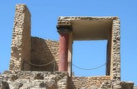
 Arkalohori at 22.2km (SW) A modern exhibition and congressional centre offering 8000 square meters of total space, 1500 of them being indoors. Among many events that take place in this centre is the Pancretan Agricultural and Commercial Exhibition of Arkalochori held every two years at the end of August. The exhibition attracts a large number of enterprises, manufacturers and services participating and is being visited by over 30,000 visitors from all over Crete. It is considered to contribute essentially in the rapid commercial and cultural development of the wider area. Photo The Municipal Open Theatre Located in the area of the exhibition centre the theatre is of semicircular shape with a capacity of approximately 1000 seats. The facility offers also a canteen, toilets, dressing-rooms for the actors, store room of scene and backstage.The cultural events that the Municipality organises every summer, attract visitors not only from the wider area but also from Iraklion city. Photo Photo  Iraklion ( Nea Alikarnassos) at 23.7km (W) Heraklion International Airport, "Nikos Kazantzakis" (Greek: Κρατικός Αερολιμένας Ηρακλείου, "Νίκος Καζαντζάκης") or Nikos Kazantzakis International Airport (IATA: HER, ICAO: LGIR) is the primary airport on the island of Crete, Greece. It is located about 5km from the main city of Heraklion. Heraklion International Airport is is one of the biggest in Greece and receives approximately 15% of the total tourist traffic of Greece. There are many airlines currently operating flights from Athens and Thessaloniki to Iraklion (Olympic Airways, Aegean Airlines and others), while during the high season there are flights from/to Rhodes, Mykonos, Santorini and other Greek islands. There are also international airlines that connects Iraklion to other European cities. During the summer season there are numerous chartered flights to Iraklion from all over Europe (mainly Germany, the United Kingdom, Russia, and Holland). During the summer months there is a huge increase in air traffic that peaks in August (approximately 130 flights per day). Major car-rental companies have desks at the airport. Taxi and public bus are available for transfer from/to Iraklion.  Mirabello, Lasstithi at 24km (SE) Lato (Gr: Λατώ) was an ancient city of Crete, the ruins of which are located approximately 3 km from the small town of Kritsa. The Dorian city-state was built in a defensible position overlooking Mirabello Bay between two peaks, both of which became acropolises to the city. Although the city probably predates the arrival of the Dorians, the ruins date mainly from the Dorian period (fifth and fourth centuries BC). The city was destroyed ca. 200 BCE, but its port (Lato Etera or Lato pros Kamara), located near Agios Nikolaos was in use during Roman rule. There is some suggestion that the city was named after the goddess Leto (of which Lato is the usual Doric form) and may be mentioned in Linear B tablets as RA-TO. Lato also minted coins in antiquity,[3] bearing the likeness of the goddess Eileithyia who appears to have been the one particularly worshipped at Lato. Nearchus, admiral of Alexander the Great, was born at Lato.  Palace and Archaeological site at 24.1km (W) The famous Palace of king Minos and the centre of the Minoan civilisation 5km south of Iraklion. The Great Palace covered an area of 20.000 sq. meters and had 1.400 rooms. Every section of the Palace had a specific use. In the west side of the Palace were the chambers of the ceremonies, of the administration and of the public storehouse...
Image Library
 Knossos Palace at 24.1km (S) The south part and south facade of the palace is very eroded. Today one can only see foundations on tiered levels. At the bottom, a tower-like projection is all that remains of the south entrance to the Palace. An asceding corridor led to the Central Court. The section of the corridor closest to the Central Court was reconstructed by Evans who put here a copy of a relief wall painting, of which only few fragments were found. On these fragments, it was possible to make out a figure wearing jewellery in the shape of lilies. The reconstruction we see here is uncertain. In Evans's opinion, it represented the "Priest-King". Other scholars think that it is a prince, whilst others believe it depicts a female figure. Anyway the original fresco which is known as the "Prince of Lilies" is one of the masterpieces in the collection of the Heraklion Museum. Image Library
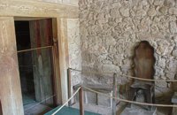 Knossos Palace at 24.1km (S) The antechamber of a complex of rooms that Evans named the "Throne Room". Its name comes from the stone seat found in the room behind the antechamber, and between them were discovered traces of a burnt wooden construction. Today, a wooden seat has been placed here which is a copy of the stone one in the neighbouring chamber. After the antechamber is the central room of the complex. Right and left of the stone seat are yet more stone benches. Pieces of fresco depicting plants and griffins, mythical beasts with a lion's body and bird's head were found in the same room. The restored fresco is in Heraklion Museum. Evans put a copy in its place. Stone vases for oil, often connected with rituals, were found on the floor. The stone basin you see was actually found in a neighbouring corridor and placed here. To the left, a low partition wall with a purification ceremonies and therefore called them "Lustral Basins". The central room connects at the back with a series of small, dark rooms which were lit by lamps, as the finds illustrate. The function of the complex is difficult to determine. Evans believed that the rooms were used for ceremonies with the main figure being the king of Knossos in his religious capacity. However, it seems unlikely to have been a Throne Room in the modern sense of the word. Image Library
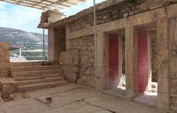 Knossos Palace at 24.1km (S) To the south of the Throne Room and the stairs, lies the area that has been identified as a shrine, called by Evans the "Tripartite Shrine" (Evans's restoration drawing). Its facade had columns and was divided into three parts, the central element being the highest. There is a depiction of a comparable shrine on a wall painting now on display in Heraklion Museum. Inside the shrine were found clay tablets in the Linear B script and clay seal impressions which were possibly connected with the archive of a shrine. The remaining areas behind the "Tripartite Shrine" are thought to have been connected with the sanctuaries of the palace. At the back, two small dark rooms with pillars are known as the "Pillar Crypts". The depresions in their floor are said to indicate that these rooms were used for libations. In another room, two large, rectangular, stone-built repositories were found, sunk into the floor. They were full of clay vases and valuable objects, amongst which were the statuettes representing the "Shake Goddess". The repositories have been interpreted as the "Temlple Repositories". The stairs on the right lead from the Central court to the upper floor of the West wing. This is largely reconstructed by Evans. Image Library
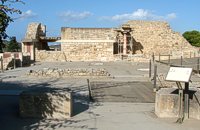 Knossos Palace at 24.1km (S) The great staircase and the upper floor to which it leads are largely Evans’ creation. Evans thought that it had a function rather like the first floor of Italian Palazzi of the Renaissance, which was called Piano Nobile. In this instance, he considered that the important reception rooms of the palace would lie on the upper floor. Evans also thought that there existed a shrine, the "Tri-Columnar Shrine", and its Treasury. The basis for his restoration lies in the column and pillar bases and the ritual stone vases found collapsed onto the ground floor, like the alabaster one in the shape of a lioness head. The rectangular building next to the stairs was built a long time after the destruction of the palace. Evans interpreted it as a "Greek Temple" based on finds of the historic period.
Image Library
|
||
|
| ||


)
)
)
)
C
O
N
T
E
N
T
S
O
N
T
E
N
T
S