interkriti®
YOUR GATEWAY TO CRETE
HOME
CRETE FACTS
NAVIGATE
EXPLORE

Agia Galini
Triopetra
Kissamos
Chryssi Isl.
Agia Marina
Balos
Gavdos isl.
Georgioupolis
SAMARIA
IDA Mtn
Palaiochora
Agia Roumeli
Sfakaki
Bali
Kalamaki
Matala
Lassithi
Plateau Lendas
Tsoutsouros
Vianos
Myrtos
Sfakia
Plakias
Ierapetra
Makrygialos
ZAKROS
Vai
Sitia
Agios Nikolaos
Elounda
MALIA
Hersonissos
Gouves
Chania
Rethymnon
Heraklion
GORTYN
FESTOS
KNOSSOS
|
|
Crete
List Grid Map
Found
147
- Showing :
81 - 100
 Iraklion Old Town at 13.7km (W) The Cathedral of St. Minas:The small church of St. Minas did not meet the religious needs of the constantly growing Christian community, so the demand arose for the erection of a new cathedral. The plot for the new church used to be a garden that belonged to a Turk from whom it was bought. The architect was Athanasios Moussis and in 1862 the foundation stone of one of the most magnificent and impressive Greek churches was laid. The outbreak of the Cretan revolution of 1866 demanded the stopping of the building work which will continue in 1883 in order to be completed in 1895, when the inauguration of the exquisite temple took place. The church is of the cruciform type with a dome based on a high spandrel, while internally there are also elements of a three aisle basilica. It has two bell towers, one in the northeastern corner and the other in the southeastern one. The right aisle is dedicated to Apostle Titos and the left one to St. Ten Martyrs of Crete. The inside of the church has gone through many changes with new additions. With plans of the architect Anastasios Orlandos the woodcut icon screen was replaced by another one made of marble, the same happened with the bishop's seat. The religious painting of the church was assigned to St. Kartakis who followed faithfully the principles and the models of the Byzantine icon painting. The hundredth anniversary from the inauguration of the Cathedral Church of St. Minas (1995) was celebrated with every solemnity that is suited in an equal occasion and more specifically to one of the most glorious and imposing Greek churches. Image Library
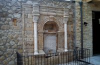 Iraklion Old Town at 13.7km (W) It was built in the end of the 17th century. Today it is found behind the Historical Museum of the city. It is decorated with two columns with floral capitals, while in between them and inside an arched construction there is a marble plaque with relief decoration. The water was running from a specially made hole at the bottom of the plaque, into a marble basin.
Image Library
 Pediada, Iraklion at 13.8km (SE) A beautiful small settlement, with 48 people, Epano Karouziana (GR: Επάνω Καρουζανά) lies at an altitude of 380m and is located at 40km from Herakleion. It is mentioned for the first time in 1842, its name was taken by a family name "Karouzos" common in the village. The village offers a spectacular view, picturesque paved lanes, traditional kafeneia and taverns and is a popular with tourists, especially in the summer when many Cretan evenings are organized with local music and dance. 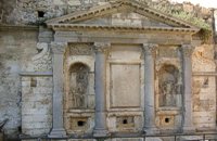 Iraklion at 13.8km (W) The «General Provisioner» Antonio Priuli made it in 1666 and it is situated today behind the "Bodosakeio" Primary School (in the area of the Venetian Dermata Gate). He decorated it with round and square columns with Corinthian type capitals, while a triangular pediment crowns the whole construction. From both sides of the columns there are niches with their metopes elaborately decorated. In the middle of the fountain there is a Turkish inscription where there is a reference to the name of the Turkish pasha who managed to bring water again in the fountain.
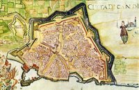 Iraklion at 14km (W) The fortified enclosure of the Venetian Chandakas of the 15th century, which is still preserved today, is one of the most significant monuments of its kind in the whole Mediterranean basin. Triangular in shape, with its base at the sea, the mighty enceinte has a perimeter of about 5.5 kilometres. The hallmark of the defensive layout are the bastions, linked by curtain walls decorated at many points by escutcheons and the lion of St. Mark, symbol of Venetian omnipotence. The gates in the enceinte, which served to link the town to the countryside, still stand as important architectural monuments. To this day, the walls that withstood the Ottoman siege in the mid-17th century mark out the boundary of the old town.  Iraklion north at 14.1km (NW) Dia (GR: Δία & Ντία) is an uninhabited island approximately 7 nautical miles north of Heraklion. It is surrounded by small rocky inlets and its maximum length is 5kms while its maximum width 3kms. Dia is one of NATURA's protected areas due to its status as a biotope for endemic plants and for plants with low dispersal within the Southern Aegean. Image Library
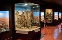 Iraklion, Dermatas Gate at 14.1km (W) The Natural History Museum of Crete is housed in the renovated former premises of the Heraklion Public Power Corporation, on Dermatas’ Bay. With an area of 3,500 m2, it is the largest exhibition of its kind in the Mediterranean, showcasing the natural environment of Crete and the wider Mediterranean area in an innovative, original way.  by Richard Ellis at 14.3km (S) 9th June- I rested for a day in the Kalliopi hotel, tended to my feet as best I could and tried to “carb-load” as instructed by my tri-athlete daughter...I made the decision to take as direct a route as I could towards Profitis Ilias in order to make my rendez-vous with Triantafyllos at Rouvas the following evening. This meant leaving the official E4 and bypassing Archanes and Ghiouktas and all the interesting historical stuff. Distance: 38.5 km Time: 11.5 hrs. Mov av 5 km/hr Height overnight: 175m.  Pediada, Iraklion at 14.4km (SE) Polythéa (GR: Πολυθέα) is located 500 m NE of Kastelli at an altitude of 335m.N Nowadays Polythea has become part of Kasteli and it has 364 inhabitants. Fr. Barozzi mentions it as Apigaiduri in 1577, belonging to the Pediada district and it continues to be known with that name until 1940, when it is re-baptized with its current name, Polythea. The previous name of the village, Pigaidouri, is originated by the word ‘pigaidi', which is Cretan for ‘pigadi', which means ‘a well'. It is a nice name that propably has been changed due to the fact that people thought it was a reference to ‘gaidouri', which means ‘donkey'. Apart from the ubiquitous raki and mezedes served at the kapheneions, you can also find rooms for rent. A typical Cretan feast is held here on August 15th for the Virgin Mary (Assumption).  Pediada, Iraklion at 14.5km (S) Kastelli (GR: Καστέλλι) is a small town in the countryside of the province of Pediada. It has over 2000 inhabitants and provides all the modern facilities and public services its residents and/or visitors may need. Many events are organized through the year by the municipality, the school and the cultural centre. In August a special festival, known as the Feast of Xenitemenou (ex-patriot feast) includes concerts, folklore, exhibitions and theatre plays.
 Archanes at 14.6km (SW) Excavations at Phourni have brought to light 26 buildings, most of which had funerary use. The cemetery was used from 2400 B.C. until 1200 B.C. and each complex had more than one architectural phase. Most of the funerary buildings were used for many decades and contain successive burials. Excavations were begun in 1964 by Efi and John Sakellarakis and have been continued until today (1995) with short interruptions. Most of the buildings are preserved in good condition.  Archanes, Iraklion at 14.8km (SW) A small traditional town (~4000 people) 15 km south of Iraklion on the foot of the sacred mountain Yiouhtas. Renowned for its excellent wine (from the varieties: vilana, kotsifali and madilari) and the archaeolocical sites and caves. In 1912, Xanthoudides noted the importance of Archanes, but Sir Arthur Evans was the first to characterize the site as palatial, declaring that Archanes was likely a Summer Palace for the Knossos kings. Spyridon Marinatos and N. Platon excavated minor areas in the region, but nothing supported Evans' theory. In 1964, J. Sakellarakis dug trial trenches at the Tourkoyeitonia site and uncovered the first evidence of a palace site. Since 1966, Archanes has been excavated by the Greek Archaeaological Society under the supervision of John Sakellarakis and Efi Sapouna-Sakellarakis. Links: http://www.archanes.gr/(GR) Image Library
 Pediada, Iraklion at 14.8km (S) 330 m above sea level, just out of Kasteli (1.5 km) to the east, lies the village of Archangelos (GR: Αρχάγγελος) with 433 residents. It was founded in 961 by the military forces of Nikiphoros Phocas and was originally named ‘Varvaro’, and was still known by that name in 1583, where the Chandax Register puts it down as a village of the Pediada district with 37 inhabitants. Its name was changed only recently, in 1961, to Archangelos, and the main village church in the square is dedicated to the Archangel Michael. There is another smaller and older church, that of the Panaghia, with Byzantine wall paintings. Remains of ancient mills can still be seen. In a location known as Trochalos, archaeological finds have brought to light a series of Minoan tools dating back to the first and second Late Minoan periods. As in every Cretan village, raki and ‘mezedes’ are always available at the kapheneions. The feast of Michail Archangelos on November 8th is celebrated with much feasting in the village.  Archanes at 15km (SW) Anemóspilia (GR: Aνεμόσπηλια). Anemospilia is an archeological site at the northern foot of Mount Yuchtas, in the prefecture of Heraklion in Crete. A rectangular building has been found which dates from the Minoan era and was destroyed by an earthquake in the 17th century BC. The building with three narrow chambers, each opening into a long corridor to the north, which extends along the whole width of the building. The area is enclosed with a stone wall and the whole structure has been interpreted as a shrine; in the central room was found a "xoanon" (statue) of the deity worshiped here. In the west room, where the altar stood, was uncovered, according to the excavator, the first human sacrifice to have ever taken place in Minoan times. (although this view has been challenged). The building at Anemospelia was used for only half a century, as it was suddenly destroyed by an earthquake in the middle of the 17th century B.C. The site was excavated in the summer of 1979 by John Sakellarakis.   Aerial view  Shrine model Links: Minoan Religion (Foundation of the Hellenic World)  Archanes at 15.1km (SW) An excellent specimen of a specialized building, one of the first structures erected during the period of the Cretan State. It was designed by the architect Salivero, one of Prince George's officials. The plans were completed in 1901 and the construction was accomplished thanks to donations of rich Archanians living in the U.S.A. The building is Pi-shaped in plan, has two storeys and a basement, it is built of stone and its roof is partially wooden and covered with tiles. It is a monumental but well balanced structure with many harmonic and elegant Neoclassical features. Since its construction, the building has been used as a school. During the German occupation it housed General Muller's division. Source: The Hellenic Ministry of Culture  Pediada, Iraklion at 15.1km (S) Diavaide (GR: Διαβαϊδέ) has 120 inhabitants and lies very near to Kasteli (700m to the SE) at 355m above sea level. The earliest reference to the name is found in the Ducal Archives at Chandax in 1378. Another document in the same archives mentions a certain G. Dochiano, inhabitant of Diavaide. In an inscription, found in the Byzantine church of Agios Georgios Sfakiotis, the name of the village is clearly mentioned, indicating that Diavaide existed well before the Turkish occupation. In that church there is a unique fresco of Byzantine art that represents Saint George and Saint Demeter passing through the sea on their horses, while at their feet lie various sea creatures; crabs, lobsters, and other fish, a strange phenomenon indeed, considering that the village is so far away from the sea. There is also the church of Agios Nikolaos in the village dated to the same period. The village took part in all the main fights by Crete against the enemies of its freedom, while during German occupation the high college of Kastelli continued to operate in Diavaide houses. The cultural association of the village, one of the first in this area, strives to maintain the cultural traditions and the continuity of village history through the years.  Iraklion at 15.1km (W) Established in 1927, AGRUNION is one of the largest agricultural cooperative unions of Greece, with 167 members of 1st degree and over 47.000 members (farmers). Its range of products include olive oil, wines, vinegar and table grapes, sold into the Greek and foreign markets. They are produced in new-built factories equipped with foremost technological equipment, totally owned by AGRUNION.  Archane, Iraklion at 15.4km (SW) The Archaeological Museum of Archanes opened in 1993. It occupies an area of 570 square meters and it is located at the Tzami quarter in the center of the settlement. There, for the first time in Crete, the archaeological finds from a single site are exhibited. While the exterior spaces of the building were adapted to a tasteful ensemble, in resemblance with the impressive modesty of the environment and the traditional ochre and rosy colour tonations of Archanes. The interior was thus arranged as to accommodate the most modern mode of exhibition, especially attractive for the visitor.  Kasteli, Pediados at 15.7km (SE) The ancient city of Lyktos or Lyttos (GR: Λύκτος / Λύττος) was one of the most ancient and powerful towns in Crete. Although the excavations in the area reveal traces of habitation from the Hellenistic years onwards (630 B.C.), the archeologists Georgios Rethemiotakis and Angeliki Lempesi have excavated traces of habitation from the time of the destruction of Lyttos by the Knossians (219 B.C.) in excavated residences of the Hellenistic period. From the Roman period, the city was subject to new workings as testified by the architectural remnants and the many inscriptions and statues discovered. Numerous vestiges of ancient structures, objects, and broken marbles are seen, as well as an immense arch of a Roman aqueduct, by which the water was carried across a deep valley by means of a wide marble channel. Traces of the aqueduct which brought its water supply from Kournia, near Krasi village, are still visible today in the rural road to Kastamonitsa village. Lyktos had also a theatre, built in the slope of the hill the design of which we know only from the drawings of Belli (1586). Finally, the most important discovery is that of a room of nearly 14 metres by 11.40 metres, with marble flooring and a series of four stone platforms along its two longer sides. The room was erected, according to the inscription that was found at the site, at the beginning of the second century B.C. This room was identified as the chamber of the Roman deputies of the city and was very probably destroyed by an earthquake at 365 AD. Lyktos appears to have still been inhabited in the 7th Century AD as indicated by the excavation of late-roman shops in the area. (Late Roman Empire, 284-610 AD)  Pediada, Iraklion at 15.7km (SE) Built at 510 m with 319 people Ksidás (GR: Ξυδάς) also known as Lyttos, is located at 3 km from Kastelli in the foothills of the site of the ancient town Lyttos. The first mention of the village goes back to 1368AD, with the name Ksidas. A burial site was discovered when the road was being constructed, at Chomatolakkos, belonging to late Roman period. Two gold rings have also been found here, the one with stone, showing the portrait of an emperor holding a spear, and the other with a hoop, showing two interlocking hands. A bronze ring with a Greek inscription, along with golden plates and bronze coins, were also found at this site. Image Library
|
||
|
| ||


C
O
N
T
E
N
T
S
O
N
T
E
N
T
S