interkriti®
YOUR GATEWAY TO CRETE
HOME
CRETE FACTS
NAVIGATE
EXPLORE

Agia Galini
Triopetra
Kissamos
Chryssi Isl.
Agia Marina
Balos
Gavdos isl.
Georgioupolis
SAMARIA
IDA Mtn
Palaiochora
Agia Roumeli
Sfakaki
Bali
Kalamaki
Matala
Lassithi
Plateau Lendas
Tsoutsouros
Vianos
Myrtos
Sfakia
Plakias
Ierapetra
Makrygialos
ZAKROS
Vai
Sitia
Agios Nikolaos
Elounda
MALIA
Hersonissos
Gouves
Chania
Rethymnon
Heraklion
GORTYN
FESTOS
KNOSSOS
|
|
Crete
List Grid Map
Found
207
- Showing :
121 - 140
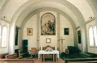 Heraklion Old Town at 22.5km (N) The Heraklion Catholic church is located at 2, Patros Antoniou street close to the old port of the city. It is dedicated to Saint John the Baptist and was first built in 1888. In the 1959 earthquake the church suffered serious damages and had to be demolished and rebuilt. The pastor at that time, Father George Roussos, built the present church in 1961-1962. Father Petros Roussos, who was Pastor from 1980 to 2008 refurbished also the Capuchin Monastery that stands next to the church.  Pediada, Iraklion at 22.5km (E) Apostoloi (GR: Αποστόλοι) is a village in the area of Kasteli, 360 m above sea level. It has about 490 inhabitants, and is located on the 32 km of the road leading to Kasteli in the NW part of Apostolianos Kampos, among vineyards and olive groves. Until recently tannery was a main activity among the villagers. The earliest reference to the name is to be found in a contract drawn in 1279, where Sancti Apostoli et Sophoro were lands belonging to the Venetian lord Leonardus Gradonicus, who gave them and leased them to Petro Quinino. There is another mention of the name in a document dated to 1378. It is also quoted by Fr. Barozzi in 1577 as forming part of the Pediada district. The name of the village finds its origins in the name of an old church dedicated to the Saint Apostles. The present church was built on the same site in the 19th century, in 1876. The church of Agios Giorgos is Byzantine and has wall paintings. According to village tradition, on the night of Easter in 1841, the Turks caught the Cretan leader of the revolution for the Eastern part of the island, Giorgos Vassilakis, or Vassilakogiorgi and hanged him from a fig tree.The village kapheneions serve particularly good raki and on June 29th there is a great feast in the honour of the Saint Apostles, Peter and Paul. 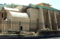 Iraklion Old Town at 22.5km (N) It is situated approximately in the middle of the seaside wall. It was built from the first years of the venetian domination and belonged to the monastic order of Dominicans (Domenicani Predicatori). It was one of the most important and biggest Catholic monasteries of the city. The earthquake of 1508 caused a lot of damages to the temple. It consists of a long aisle which is roofed by a two slope roof and ends at a sanctuary roofed by two vaults. To the north and south wall of the temple there are windows of different types that were opened either during the Turkish period, or even earlier. Image Library
 Cretan Singer and lyra player from Anogeia at 22.6km (NW) Nikos Xylouris (Greek: Νίκος Ξυλούρης, 7 July 1936 - 8 February 1980), nicknamed Psaronikos (Greek: Ψαρονίκος, "Grey Nick"), was a Greek composer lyra (Cretan lyre) player and singer from the town of Anogeia. He was part of the movement that brought down the Greek military Junta of 1967. His songs and music captured and described the Greek psyche and demeanor, gaining himself the title the archangel of Crete. Image Library
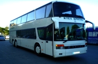 Heraklion Port at 22.6km (N) Crete Public Bus Services (KTEL) with modern air conditioned buses and experienced personnel, offer travelling people, secured, comfortable, quick & affordable transportation almost to the most remote spot of the island. The bus station at Iraklion is situated at the port only a few minutes walk from the town's center. Timetables : East Crete Timetables-KTEL Heraklio - Lassithi West Crete Timetables-KTEL Hania - Rethymnon  Pediada, Iraklion at 22.7km (E) Evangelismos (GR: Ευαγγελισμός) at 360 m above sea level, with 365 inhabitants, lies to the SW of Kasteli, distant only 5 km from the county town and about 35 km from Heraklion. In earlier years, the village was called Mouktari or Mouchtari and its name figures in a 1381 contract for the buying and selling of grain. The Byzantine church of the Panagia is worth a visit. On August 6th the village celebrates the feast of the Metamorphosis. Evangelismos is the seat of the newly (2010) created municipality, according to the National "Kallikratis Project", by uniting the former municipalities of Kastelli, Thrapsano and Akalochori. The name of the new municipality is "Minoa Pediada"  Iraklion at 22.8km (N) Since 1985, with hard work, we have managed to become well known and trusted car hire company, not only in Crete but also amongst our numerous customers from Europe and other countries. We are the cheapest in town. We deliver to port, airport and hotels. Full insurance without excess. - New models, Safe Cars, Special Offers. No deposit required for booking.  Iraklion Venetian port at 22.9km (N) A seaside fortress situated at the entrance of the old harbour. It was built by the Venetians, before the construction of the new Venetian fortification, in order to protect the pier and the port. It took its last shape in the years between 1523 - 1540 replacing another construction destroyed by an earthquake. Image Library
 Milopotamos, Rethymno at 23.1km (NW) Anogia is a mountain town with 2500 permanent residents and is 55 km away from Rethymnon and 36 km from Iraklion. The name Anogia, means "high place - Ano Gi", is connected with the location that is built, in altitude of 700 m. Hospitable and pleasant residents have to tell a lot of old stories that have marked the tradition and the culture of the village. Anogia is a well-known village historically for its resident's resistance to the conquerors, Turkish and Germans.
Image Library
 Iraklion ( Nea Alikarnassos) at 23.2km (NE) Heraklion International Airport, "Nikos Kazantzakis" (Greek: Κρατικός Αερολιμένας Ηρακλείου, "Νίκος Καζαντζάκης") or Nikos Kazantzakis International Airport (IATA: HER, ICAO: LGIR) is the primary airport on the island of Crete, Greece. It is located about 5km from the main city of Heraklion. Heraklion International Airport is is one of the biggest in Greece and receives approximately 15% of the total tourist traffic of Greece. There are many airlines currently operating flights from Athens and Thessaloniki to Iraklion (Olympic Airways, Aegean Airlines and others), while during the high season there are flights from/to Rhodes, Mykonos, Santorini and other Greek islands. There are also international airlines that connects Iraklion to other European cities. During the summer season there are numerous chartered flights to Iraklion from all over Europe (mainly Germany, the United Kingdom, Russia, and Holland). During the summer months there is a huge increase in air traffic that peaks in August (approximately 130 flights per day). Major car-rental companies have desks at the airport. Taxi and public bus are available for transfer from/to Iraklion. 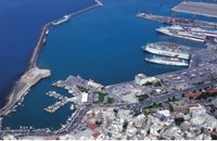 Iraklion at 23.5km (N) The Port of Heraklion is the main and most modern gateway for the transport of passengers and commodities on the island of Crete. There are three main companies that connect Iraklion to mainland Greece, Minoan Lines, Superfast Ferries and ANEK. During the winter months there are daily trips from Athens to Iraklion. The trip takes approximately 6 - 9 hours by ferry boat. The ships depart Athens in the evening (10.30 p.m.) and arrive in Iraklion at 5:00 - 6:00 a.m. There is also a weekly trip to Thessaloniki. During the summer season all companies operate also an extra daily trip that departs in the morning from Athens and arrives at Iraklion port in the afternoon. Finally various other companies operate ships connecting Iraklion with other island in the Aegean (Rodos, Santorini etc.). Daily cruises are also offered to the island of Santorini. Image Library
 Moires, Messara at 23.6km (SW) The monastery of Panagia Kaliviani is located at the 59th km on the road Iraklion-Phaistos. The monastery was built during the second Byzantine period. The small Byzantine chapel was painted with frescoes but most of them are today destroyed. The chapel was deserted until, during the Turkish occupation in 1873, an old small icon of the Annunciation of the Holy Mother was miraculously found there.and the monastery became a place of worship.  Malevizi, Iraklion at 23.7km (N) Dóxa (GR: Δόξα) is a pretty village built on a height of 400 metres above sea-level and 20 kilometres to the west of Heraklion on the road to the mountainous Milopotamos. The historical cave of Dóxa (GR: Δόξα) is located in a short distance from the village of Marathos on the road to Heraklion. It is at a height of 490 metres above sea-level, near a well-known taverna also called DOXA. The cave has a total length of 50 metres and impressive stalactites and stalagmites.  Iraklion at 23.8km (NE) This 2 km long sandy beach was for years and still is the favorite beach of the people of Heraklion town. It is named after the river "Karteros" which outflows at the west end of it near the airport. The water is clean, the seabed is sandy with smoothly shelving and swimming is safe. The access is free in most parts except for some areas that are reserved for military personnel and the municipal beach "Akti" where visitors should pay an entrance fee in order to use the facilities. At the east end there are some very good taverns offering fresh fish among their specialties and are very popular with locals and tourists alike.
Image Library
 Pediada, Iraklion at 24.1km (E) 330 m above sea level, just out of Kasteli (1.5 km) to the east, lies the village of Archangelos (GR: Αρχάγγελος) with 433 residents. It was founded in 961 by the military forces of Nikiphoros Phocas and was originally named ‘Varvaro’, and was still known by that name in 1583, where the Chandax Register puts it down as a village of the Pediada district with 37 inhabitants. Its name was changed only recently, in 1961, to Archangelos, and the main village church in the square is dedicated to the Archangel Michael. There is another smaller and older church, that of the Panaghia, with Byzantine wall paintings. Remains of ancient mills can still be seen. In a location known as Trochalos, archaeological finds have brought to light a series of Minoan tools dating back to the first and second Late Minoan periods. As in every Cretan village, raki and ‘mezedes’ are always available at the kapheneions. The feast of Michail Archangelos on November 8th is celebrated with much feasting in the village.  Pediada, Iraklion at 24.4km (E) Village of the area of Kastelli with 115 residents, Agia Paraskevi is situated 5 km northeast of Kastelli at an altitude of 400m. It is first mentioned in the Turkish census of 1671 as Agia Paraskevi tou Xourdou with 17 haratsia (head tax). It is very possible that Santa Venerata, a village mentioned in 1463 by Cardinal Bissarion, is the name by which Agia Paraskevi was known at that period.  Pediada, Iraklion at 24.4km (E) At an altitude of 380m, with 63 inhabitants, Liliano (GR: Λιλιανό) is first mentioned in the Turkish census of 1671. The Basilica with its three naves, dedicated to Saint John, was built in the 12th -13th centuries and is one of the oldest and the most interesting in Crete. The stones used in its construction came from earlier buildings. The three naves, with the middle nave higher than the other two, are supported by columns in Ionic style. The narthex in front is lower with wider arches, whereas the door and windows have pointed arches.  Voroi, Messara, Iraklion at 24.5km (W) The exhibited objects in the Museum come from all over Crete. These objects show that the folk culture of Crete is characterized by an amalgam of influences in which Minoan (2000-1000 BC), Archaic (1000-500 BC) and Byzantine models prevail, especially in agriculture, stock breeding, pottery and basketry.
 Messara, Iraklion South at 24.6km (W) Vori is a beautiful, traditional village of the county of Pirgiotissas in the Messara Valley. It is located 60 km south of Iraklion and in the western part of the Messara Valley. The village stretches in a slope, by the side of a small river. The archaeological site of Phaistos is 2 km to the south and the coast of Messara 4 km to the west.
 Pediada, Iraklion at 24.6km (NE) The village of Smári (GR: Σμάρι) is a traditional Cretan village, only 10 km away from Kasteli and has 375 inhabitants. In it you will find beautiful old stone houses that have been restored, picturesque little alleys, ruins of older buildings and pottery workshops where you can purchase copies of Byzantine and Minoan ceramics. There are also some interesting churches with wonderful frescoes like the one dedicated to Sotir Christos, the Koimisi tis Panagias and Agios Giorgos. The earliest reference to the village of Smari dates back to 1375. There is a lively Cretan feast on July 20th in honour of Profitis Ilias, with much rejoicing, singing and dancing. |
||
|
| ||


C
O
N
T
E
N
T
S
O
N
T
E
N
T
S