interkriti®
YOUR GATEWAY TO CRETE
HOME
CRETE FACTS
NAVIGATE
EXPLORE

Agia Galini
Triopetra
Kissamos
Chryssi Isl.
Agia Marina
Balos
Gavdos isl.
Georgioupolis
SAMARIA
IDA Mtn
Palaiochora
Agia Roumeli
Sfakaki
Bali
Kalamaki
Matala
Lassithi
Plateau Lendas
Tsoutsouros
Vianos
Myrtos
Sfakia
Plakias
Ierapetra
Makrygialos
ZAKROS
Vai
Sitia
Agios Nikolaos
Elounda
MALIA
Hersonissos
Gouves
Chania
Rethymnon
Heraklion
GORTYN
FESTOS
KNOSSOS
|
|
Crete
List Grid Map
Found
142
- Showing :
121 - 140
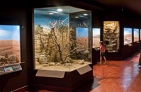 Iraklion, Dermatas Gate at 20.6km (W) The Natural History Museum of Crete is housed in the renovated former premises of the Heraklion Public Power Corporation, on Dermatas’ Bay. With an area of 3,500 m2, it is the largest exhibition of its kind in the Mediterranean, showcasing the natural environment of Crete and the wider Mediterranean area in an innovative, original way.  Iraklion at 21.3km (W) Established in 1927, AGRUNION is one of the largest agricultural cooperative unions of Greece, with 167 members of 1st degree and over 47.000 members (farmers). Its range of products include olive oil, wines, vinegar and table grapes, sold into the Greek and foreign markets. They are produced in new-built factories equipped with foremost technological equipment, totally owned by AGRUNION.  Iraklion north at 21.8km (NW) Dia (GR: Δία & Ντία) is an uninhabited island approximately 7 nautical miles north of Heraklion. It is surrounded by small rocky inlets and its maximum length is 5kms while its maximum width 3kms. Dia is one of NATURA's protected areas due to its status as a biotope for endemic plants and for plants with low dispersal within the Southern Aegean. Image Library
 Iraklion at 22km (W) The TEI, located on the beautiful island of Crete, was founded in 1983 in order to provide Higher Technical Education to the students of Greece. Since then it has expanded and developed considerably, and now comprises the Schools of Applied Technology (also in Chania and Rethimno) Health & Welfare Services Management & Economics (also in Agio Nikolao and Ierapetra) and Agricultural Technology assisted by he Departments of General Sciences, Foreign Languages and Physical Education. Students at the TEI follow courses for 4 years including lectures and practical work in laboratories. In addition, they complete a work placement and dissertation before graduating. Education at the TEI offers up to date training in technological subjects and prepares students to develop into skilled, responsible and qualified members of society. With a permanent teaching staff of 200 and approximately 10.000 students the TEI of Heraklion is a thriving academic community with an extensive library, student halls of residence, sport facilities and a health center. P.O. Box 1939 IRAKLIO, Crete, Greece, GR 710 04 Tel: Fax: +30 281 0379328 http://www.teicrete.gr  Iraklion at 22.1km (W) Capacity: 26,240 (seated)- Location: The stadium is located in Heraklion (also: Iraklio) 3 km west of the city centre (at Lido beach)... The building began 15 years ago and the 2004 Olympic Games proved to be the golden opportunity for the Pancretan, as the Athens Organising Committee named it as one of the venues of the football tournament. It was inaugurated on 31 March 2004, when it hosted an international friendly match between the National teams of Greece and Switzerland. The stadium is currently the second largest stadium of the country. The stadium is actually part of a sports complex. A training ground with an 8-lane athletics track, Lido Indoor Hall, and a swimming pool are located right next to the Pancretan Stadium. Image Library
 Iraklion at 23km (W) The town of Profitis Ilias (GR: Προφήτης Ηλίας), or Roka for the locals, is found 20km south of Heraklion It is built on the top of two hills offering an unforgettable view to the surrounding areas. A natural fortification, due to its position, it has been suggested that ancient Lycastos was built here. It is also known as Kandli Kasteli due to the castle located at the summit of a rock southeast of the town. Nikiforos Fokas built the Byzantine castle of Temenos in the same location in 961 when he freed the island from the Saracens. His objective was to bring the city of Hantaka (Heraklion) into the castle of Temenos. However, this did not materialize and the city remained were it was. In the thirteenth century the castle of Temenos was occupied by the Genoese Pescatore, and later by the Venetians. The name Kanli Kastelli in Turkish means blood-painted castle, and took its name from a massacre of Turks by the Venetians and Greeks that took place here in 1647.  Stavrakia, Iraklion at 23.4km (W) The University Hospital of Heraklion (Pa.G.N.I.) is the largest hospital facility in Crete and one of the largest public hospitals in the country. The Pa.G.N.I. provides secondary and tertiary health care in a wide range of clinical specialties, diagnostic and laboratory tests. It is located 8km away from the city of Heraklion in the area of Stavrakia, next to the School of Medicine of the University of Crete Telephone: +30 2813 402111 & 2810 392111 Website: www.pagnh.gr/  Voutes Iraklion & Rethymno at 23.6km (W) The University of Crete, is multi-disciplinary, research- oriented Institution, situated in the cities of Rethymnon and Heraklion. It is a University with a well-known reputation both nationally and internationally, with state-of-the art curricula and graduate programmes, considerable research activity and initiatives that reflect its dynamic character. It was established in 1973 and operated during the academic year 1977-1978. Today, approximately 10628 students attend the University. The University's staff consists of 580 Teaching and Research Staff members. Its' operation is supported by more than 400 administrative staff.  Mirabello, Lassithi at 24.3km (E) Neapolis is located 15 km westwards of Agios Nikolaos on the way to Heraklion from where it is roughly 50 km far. Neapolis is built in the green valley of Mirabello. In the period of the Venetian domination its two settlements were named "New Village". But when the seat of the Prefecture was transferred from Fourni to the “New Village” this last was renamed to Neapolis. Neapolis was maintained as the capital of the prefecture of Lasithi till 1904. After that date Agios Nikolaos became the new capital.  Voutes, Iraklion at 24.4km (W) The Foundation for Research and Technology – Hellas (FORTH) is one of the largest research centers of Greece with well - organised facilities and a highly qualified staff. It functions under the supervision of the General Secretariat for Research and Technology of the Hellenic Ministry of Development and consists of seven Research Institutes, which are located in various regions of Greece: Heraklion, Rethymno, Patras and Ioannina. The Foundation’s headquarters, as well as the Central Administration offices are located in Heraklion, Crete.  by Richard Ellis at 24.6km (W) 10th June- I packed up the tent early after a noisy night of competing dogs and was on the road by 0615. After 3 or 4 kilometres on a mix of dirt roads and tarmac roads, I managed to find the concrete road which is the official E4 (marked with paint on a concrete watertank) up from Pirgos and a couple of hours later I was in Venerato having a frappe in the café by the turn to Kerasia.. Distance:35.8km Time: 13.75 hrs. Mov av 3.9 km/hr Height overnight: 945m. Max. height: 1600m  Iraklion at 24.9km (W) Ammoudara (GR: Αμμουδάρα) is four kilometre long sandy beach that stretches from the west end of Heraklion to Linoperamata near the village of Gazi. The sand is fine and blond and extends several metres to the land and the sea is clear and safe. The predominant winds during the summertime are N, N-W usually "meltemi" that get more fresh at the western end of the beach, where the windsurf school is located. Along the shore there are hotels, some of them very large complexes, taverns, restaurants, bars, cafes etc that offer umbrellas and sun-beds on the beach. There are also lifeguards in some spots. The area in general is touristic and offers a full range of facilities, among them the modern multiplex "Technopolis" with cinema and an open-air theater. Image Library
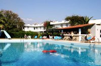 Ammoudara Beach, Iraklion at 25.2km (W) Gorgona is a family run hotel that offer all the modern amenities. It has its own swimming pool, and is surrounded by its own gardens with lush tropical vegetation, that spread on 5000 sq. meters. There is also a lounge with TV, bar, restaurant, reception, pool bar and a large private parking area. The 39 rooms have their own balconies, private bath, central heating, air conditioning, TV, radio, refrigerator, telephone and safe box. Sandy beach is only 200m away. Open all year round
 South east Iraklion at 25.6km (S) Historical place with outstanding natural beauty, unspoiled villages and great beaches. The town of Ano Viannos is built amphitheatrically on the southern slopes of Dikti mountain at 560 m. above sea in a distance of 65km from Iraklion and 40km from Ierapetra. It preserves the traditional character with the narrow paved streets, the stone built houses - especially the "Plaka' quarter - the old kefeneios with tables under the plane trees and old churches such as Agios Georgios and Agia Pelagia with wall paintings dating back to the 14th century. There are a few accommodation facilities, banks, medical center, taverns, gas stations, shops etc. Ano Viannos is the seat of the municipality of Viannos.
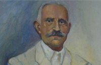 born in Viannos at 25.6km (S) Author and journalist(1862-1920). He was born in the village Ano Viannos in 1862. In his childhood he moved with his family in Piraeus. Quite soon though, only 3 years later, they got back at their special homeland and there, he finished the elementary school. Though he'd started attending high school in Iraklion, he finished it in Varvakeio School, in Athens. His first novel was published in the newspaper 'Estia', in 1884. He was enrolled in the Philosophy School, but he never graduated. In 1885 he got back in Crete, where he took a job as a teacher in Modi, Kydonias. His revolutionary character motivated him into writing patriotic articles in the local paper, an act that infuriated the Turkish occupants to such an extent that he had to flee in Athens, only this time he stayed permanently. In Athens he worked for several newspapers like 'Estia', 'Asty' and 'Embros'. For more than 20 years he kept writing chronicles, which helped him win respect among the intellectuals. He used to use the pseudonym 'Diavatis' (Passer-by). During his long literary career he wrote: 'Gramvoussa, i epanastasis en Kriti' (Gramvoussa, the revolution in Crete), 'I olokaftossis tou Arkadiou' (The Holocaust of Arkadi), 'Otan imoun daskalos' (When I was a teacher), 'Proti Agapi' (First Love), 'Eno diavaina' (When I was passing by), 'O Patouchas', 'Zampeliou Kai Kritovoulidou, Istoria Kritikon Epanastaseon' (Zampeliou and Kritovoulidou, Cretan Revolutions History), 'Imere kindynon kai fovou' (Days in danger and terror). Kondylakis’ entire work is collected in his 'Apanta' (Collected works).Ioannis Kondylakis died in Irakleion, in 1920.  Malevizi, Iraklion at 27.6km (W) Petrokéfalo (GR: Πετροκέφαλο) lies 16km from Iraklion and 3km from Agios Myron at 340m a.s.l with 248 inhabitants. It is built on a rocky hillside. The hill' shape resembles to a human head and it is supposed that the village owes its name to this (petrokefali = stone head) . The settlement was fortified and lately were discovered significant ancient findings. The patron Saint is "Agia Paraskevi" and there is a village feast on the 8th September in her honour.
 by Richard Ellis at 27.7km (SE) It was a familiar performance trying to find the right path out of Selakano. T's map v T's GPS (didn't show the start) v LW's words. Together they made no real sense, because the map was saying that the footpath ran due west out of Selakano while LW’s suggested route was taking me north. In the end good old red paint splashes got me going westwards along a concrete path (starting beside a concrete structure) not far north of the junction between the bunkhouse square and Stella’s taverna. You have to follow your nose here as the paths stop and start a bit, but the GPS did clutch in quite quickly and, as ever, was reliable. Distance:22km Time: 9 hrs. Mov av 3.4 km/hr Height overnight: 824m.(max 2,148m.)  Malevizi, Iraklion at 28.6km (W) Agios Myron, with 708 inhabitants, lies 18 km from the city of Iraklion to the south west. Its one of the most important villages of the area with interesting town planning and impressive samples of traditional architecture. Built between two hills it commands a panoramic view and the school's clock, its main characteristic, is visible from almost everywhere in the area of Malevizi.  Malevizi, Iraklion at 28.7km (W) Pentamódi (GR: Πενταμόδι)one of the oldest villages in Crete, is located in the valley of Gazanos river, 17km from Iraklion and 4km from Agios Myron at 350m a.s.l with 278 inhabitants. At "Agia Paraskevi" a place with rich vegetation are organized every summer a series of cultural festivals. A fountain of the 15th century with the blazon of the house of "Quirini" is one of the significant monuments of the area. The patron Saint is "Agios Nikolaos" and there is a village feast on the 26th July in his honour.  Kenouriou, Iraklion at 28.8km (SW) Doúli (GR: Δούλι) is a village in Kenouriou county, located 38 km from Iraklion at an altitude of 440 m above sea level. The earliest reference to it, is to be found in the Duke's Archives of 1372, where it is mentioned as the feudal property of Nic. Venerio. The name figures in all the Venetian censi of the 16th and 17th centuries, as well as in the Turkish (1671) and Egyptian (1834) censi. In 1881, Douli forms part of the municipality of Megali Vrisi with about 170 inhabitants, and again in 1900 with only 21 inhabitants. As of 1920, Douli is a commune in its own right, and today Douli has about 240 residents. The patron saint of the village is Aghios Panteleimonas and the feast of the Saint is celebrated on July 27th.A visit to the old church of Aghios Nikolaos is also a must. For those interested in paleontology, there are fossils to be found at the location 'Pirgos'. |
||
|
| ||


)
)
)
C
O
N
T
E
N
T
S
O
N
T
E
N
T
S