interkriti®
YOUR GATEWAY TO CRETE
HOME
CRETE FACTS
NAVIGATE
EXPLORE

Agia Galini
Triopetra
Kissamos
Chryssi Isl.
Agia Marina
Balos
Gavdos isl.
Georgioupolis
SAMARIA
IDA Mtn
Palaiochora
Agia Roumeli
Sfakaki
Bali
Kalamaki
Matala
Lassithi
Plateau Lendas
Tsoutsouros
Vianos
Myrtos
Sfakia
Plakias
Ierapetra
Makrygialos
ZAKROS
Vai
Sitia
Agios Nikolaos
Elounda
MALIA
Hersonissos
Gouves
Chania
Rethymnon
Heraklion
GORTYN
FESTOS
KNOSSOS
|
|
Crete
List Grid Map
Found
220
- Showing :
161 - 180
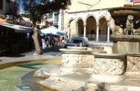 Iraklion Old Town at 40.4km (NW) The "Morosini's fountain" or "Lions' fountain" that dominates the center of Eleftherios Venizelos square in Iraklion old town, is a landmark both for locals and visitors. A masterpiece of the Venetian era that would be the pride of any city in the world. It was made in 1628 AD, under the supervision of the General Provisioner Francesco Morosini, to satisfy Candia's (Candia was the Venetian name of Crete and its capital - Iraklion - as well) needs for water. For this purpose an aqueduct was constructed to bring the water from the sacred mountain Giouhtas. Image Library
 Iraklion Old Town at 40.4km (NW) With the recovery of Crete from Nikiforos Fokas (961AD), the seat of the bishopric is transferred from Gortyna to Chandakas, which became the capital of the island. The new cathedral, which is the most established and largest in the city, is dedicated to the Apostle Titos. Here, amongst other relics, there are gathered the Holy Skull of the Apostle and the miracle working icon of Messopapaditissas. Image Library
 Iraklion Old Town at 40.4km (NW) The Cathedral of St. Minas:The small church of St. Minas did not meet the religious needs of the constantly growing Christian community, so the demand arose for the erection of a new cathedral. The plot for the new church used to be a garden that belonged to a Turk from whom it was bought. The architect was Athanasios Moussis and in 1862 the foundation stone of one of the most magnificent and impressive Greek churches was laid. The outbreak of the Cretan revolution of 1866 demanded the stopping of the building work which will continue in 1883 in order to be completed in 1895, when the inauguration of the exquisite temple took place. The church is of the cruciform type with a dome based on a high spandrel, while internally there are also elements of a three aisle basilica. It has two bell towers, one in the northeastern corner and the other in the southeastern one. The right aisle is dedicated to Apostle Titos and the left one to St. Ten Martyrs of Crete. The inside of the church has gone through many changes with new additions. With plans of the architect Anastasios Orlandos the woodcut icon screen was replaced by another one made of marble, the same happened with the bishop's seat. The religious painting of the church was assigned to St. Kartakis who followed faithfully the principles and the models of the Byzantine icon painting. The hundredth anniversary from the inauguration of the Cathedral Church of St. Minas (1995) was celebrated with every solemnity that is suited in an equal occasion and more specifically to one of the most glorious and imposing Greek churches. Image Library
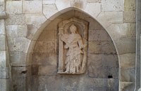 Iraklion Old Town at 40.4km (NW) It was made by Giovanni Sagredo between 1602-1604, part of it has been built in the Northwest corner of today's Loggia (Town Hall) and it is decorated with a carved female statue which according to Gerola's description probably with the left hand she was holding a shield, while with the right one a kind of a big hammer for display, representing the personification of Crete.
 Heraklion old town at 40.4km (NW) The Basilica of Saint Mark is one of the most important Venetian buildings-monuments in Heraklion. Today it houses the city’s Municipal Art Gallery. The Venetians, wishing to consolidate their dominance over their new colony (Heraklion) and to express their gratitude and love for their mother country, built a church in the city’s centre dedicated to Saint Mark, patron saint of Venice. The Basilica managed to survive various earthquakes which afflicted Heraklion over the centuries with only minor repairs. During the Turkish rule it was converted into a mosque, the Defterdar Mosque, named after Defterdar Ahmet Pasha, the head of the financial department. The Ottomans demolished the bell-tower of the basilica and raised a minaret in its place, which in its turn was taken down by the residents of Heraklion after the liberation of the island in their attempt to erase the unpleasant reminders and symbols of the Turkish occupation.
Image Library
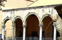
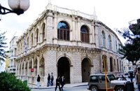 Heraklion old town at 40.4km (NW) It is an essential public building in every Venetian city, which was not absent even from the colonies. For Candia, Loggia is considered to be one of the most elegant architectural monuments of the Venetian period, a representative sample of the palladian style. During the Venetian period, Loggia was the official meeting place of sovereigns and nobility where they discussed various topics that had to do with economic matters, commercial, and political ones.
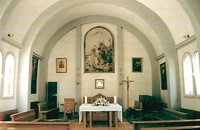 Heraklion Old Town at 40.5km (NW) The Heraklion Catholic church is located at 2, Patros Antoniou street close to the old port of the city. It is dedicated to Saint John the Baptist and was first built in 1888. In the 1959 earthquake the church suffered serious damages and had to be demolished and rebuilt. The pastor at that time, Father George Roussos, built the present church in 1961-1962. Father Petros Roussos, who was Pastor from 1980 to 2008 refurbished also the Capuchin Monastery that stands next to the church. Heraklion Chamber of Commerce and Industry Iraklion at 40.5km (NW) The Heraklion Chamber of Commerce and Industry constitutes an advisory and consultatory body for both the State and its member-enterprises. Its objective is to represent, follow up and promote industry, manufacture, trade and services aiming at the growth of the local and national economy. It houses also The European Information Center. 9 koronaiou Str., GR 71202, Heraclion Crete, Greece PO BOX: 1154-71110 tel.: + 30 2810 229013 / fax + 30 2810 222914 e-mail: info@ebeh.gr, http://www.ebeh.gr  Malevizi, Iraklion at 40.5km (NW) Ano Asites (GR: Ανω Ασίτες) lies 24km from Iraklion and 6km from Agios Myron at 480m a.s.l with 423 inhabitants. A big part of the surrounding area is covered by forest on the eastern side of the mountain Psiloritis. Near the village there is the Byzantine chapel of Agios Antonios located in the ravine with the same name a place of exceptional natural beauty. From here passes the European Hiking Path (E4) which leads to the shelter "Prinos" ( of the Mountaineering Club of Iraklion - altitude 1100 m a.s.l.) located in a holly (=prinos) forest.  Stavrakia, Iraklion at 40.6km (NW) The University Hospital of Heraklion (Pa.G.N.I.) is the largest hospital facility in Crete and one of the largest public hospitals in the country. The Pa.G.N.I. provides secondary and tertiary health care in a wide range of clinical specialties, diagnostic and laboratory tests. It is located 8km away from the city of Heraklion in the area of Stavrakia, next to the School of Medicine of the University of Crete Telephone: +30 2813 402111 & 2810 392111 Website: www.pagnh.gr/  Iraklion Venetian port at 40.7km (NW) A seaside fortress situated at the entrance of the old harbour. It was built by the Venetians, before the construction of the new Venetian fortification, in order to protect the pier and the port. It took its last shape in the years between 1523 - 1540 replacing another construction destroyed by an earthquake. Image Library
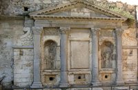 Iraklion at 40.7km (NW) The «General Provisioner» Antonio Priuli made it in 1666 and it is situated today behind the "Bodosakeio" Primary School (in the area of the Venetian Dermata Gate). He decorated it with round and square columns with Corinthian type capitals, while a triangular pediment crowns the whole construction. From both sides of the columns there are niches with their metopes elaborately decorated. In the middle of the fountain there is a Turkish inscription where there is a reference to the name of the Turkish pasha who managed to bring water again in the fountain.
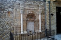 Iraklion Old Town at 40.7km (NW) It was built in the end of the 17th century. Today it is found behind the Historical Museum of the city. It is decorated with two columns with floral capitals, while in between them and inside an arched construction there is a marble plaque with relief decoration. The water was running from a specially made hole at the bottom of the plaque, into a marble basin.
Image Library
 Iraklion town at 40.8km (NW) The history and culture of Crete, from the first centuries of the Christian era to our present time. An exceptional museum featuring a collection of extremely precious objects, a must see for every visitor to Crete. The museum is housed in a two storey neoclassical building, which was constructed in 1903 on the site of an earlier mansion.
 Messara, Iraklion South at 40.8km (W) Agioi Déka (GR: Αγιοι Δέκα) is a town with 820 inhabitants in the plain of Messara, 170m above sea level, 43 km from Heraklion town and very close to the archaeological site of Gortyna. Its people are occupied mostly in agriculture - vines and olive trees. In the area there is is the oldest olive grove in Crete. The town is built on the ruins of the ancient town of Gortyn where the Holy Ten Martyrs have been martyred.  Voutes Iraklion & Rethymno at 40.8km (NW) The University of Crete, is multi-disciplinary, research- oriented Institution, situated in the cities of Rethymnon and Heraklion. It is a University with a well-known reputation both nationally and internationally, with state-of-the art curricula and graduate programmes, considerable research activity and initiatives that reflect its dynamic character. It was established in 1973 and operated during the academic year 1977-1978. Today, approximately 10628 students attend the University. The University's staff consists of 580 Teaching and Research Staff members. Its' operation is supported by more than 400 administrative staff. 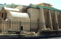 Iraklion Old Town at 40.8km (NW) It is situated approximately in the middle of the seaside wall. It was built from the first years of the venetian domination and belonged to the monastic order of Dominicans (Domenicani Predicatori). It was one of the most important and biggest Catholic monasteries of the city. The earthquake of 1508 caused a lot of damages to the temple. It consists of a long aisle which is roofed by a two slope roof and ends at a sanctuary roofed by two vaults. To the north and south wall of the temple there are windows of different types that were opened either during the Turkish period, or even earlier. Image Library
 Malevizi, Iraklion at 40.8km (NW) Kato Asites (GR: Κάτω Ασίτες lies 23km from Iraklion and 5km from Agios Myron at 450m a.s.l with 1113 inhabitants. Beautiful town with traditional architecture especially the quarters "Notiko", "Prinos" and "Kastella" close to the monastery of Gorgolaini. Other interesting sights are: The thermae of the king of Prinias, The uninhabited settlement of Nisi with traditional houses, the caves "Lesta spilios" at Marias aloni, "Astirakou spilios", "Sarakina" and "Katsivli spilios" at Lyssogremia and "Melissa", The chapels of "Panagia" aged 800 years, "Agios Antonios" aged 1000 years, "Agios Georgios" and "Agia Paraskevi". The patron Saint is "Agia Paraskevi" celebrated on the 26th July .  Malevizi, Iraklion at 40.9km (NW) Pentamódi (GR: Πενταμόδι)one of the oldest villages in Crete, is located in the valley of Gazanos river, 17km from Iraklion and 4km from Agios Myron at 350m a.s.l with 278 inhabitants. At "Agia Paraskevi" a place with rich vegetation are organized every summer a series of cultural festivals. A fountain of the 15th century with the blazon of the house of "Quirini" is one of the significant monuments of the area. The patron Saint is "Agios Nikolaos" and there is a village feast on the 26th July in his honour.  Beach in South Iraklion at 41km (W) Tripití (or Trypití GR: Τρυπητή) is a 400m long beach on the southern Asterousia coastline. It is located 57km from Heraklion (west gate, Giofyros) via Agioi Deka - Vagionia - Vassiliki - Trypiti road. The last 10km, from Vassiliki to Trypiti, is a dirt but in fairly good condition road. The road passes over the gorge of Agios Savvas, with spectacular rocky walls, then through a forest of olive and carob trees and finally via the gorge of Trypiti through a very narrow passage reaches the beach. This is a very interesting route with breathtaking views and fantastic scenery. Image Library
|
||
|
| ||


)
)
)
)
C
O
N
T
E
N
T
S
O
N
T
E
N
T
S