The area of
MOURNIES
Prefecture of: Hania
County of: Kydonia
telephone code: +30821
The area of Mournies covers 178,782,000 sq.m most of them mountainous, and comprises 14 municipalities with 31 villages or settlements.
The gorges and the forest compose an imposing landscape and make the area one of the most worth to visit places in Crete.
The villages of the area
(in alphabetical order)
The municipality of
Mournies
The village of Mournies, seat of the municipality of the same name, is a principal village of 5,318 permanent inhabitants, located 3.8 km south of Hania at 40m a.s.l.
It took the name "Mournies" from the numerous mulberry trees, that use to be here even today.
At the beginning of the 17th century, Mournies was famous for its beautiful villas, belonging to local noblemen. One of them, located southeast of the village, was the imposing three level villa of "Koukounara"
It had beautiful flowery gardens, fountains, statues ... a real paradise, where many famous persons were received hospitality, amongst them the glorious Mme Ortans, the empress Eugene of Napoleon the third, queen Olga of Greece, and the king Constantinos in 1913.
The villa today, being restored, houses a department of the Geek Navy.
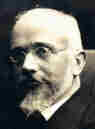 Mournies was the birth place of one of the greatest statesman of the new Hellenic Republic, Eleftherios Venizelos. Venizelos' influence on the history of Greece was paramount, from his participation to the talks with the Ottomans that resulted to granting Crete independence in 1897, to the final union of Crete with Greece in 1913.
The house of Venizelos located in Mournies is going to be a museum, and many personal items of the politician are going to be on display there.

The municipality of
KERAMIA
The municipality of Keramia consists of 16 small villages, scattered on the northern slope of Keramos, a peak of the White mountains (Lefka Ori).
The torrent "Keramiotis" crosses the area creating the small gorge of "Stilos".
There are two hypotheses regarding the origin of the name "Keramia". One suggests that it comes from the mountain Keramos, and another that it is due to the pottery workshops (keramia) that once used to be in the area.
Drakona
The village of Drakona is located 22.5 km south of Hania at 510m a.s.l. with 251 inhabitants.
It is part of the municipality of Keramia.
From here starts an amazing course of 7 km (dirt road) through the forest to the village of Therisso.
Kondopoula
Kondopoula (104 inhabitants) and Katohori (189), two neighbouring villages of the municipality of Keramia located 20 km from Hania.
Kambi
The village of Kambi is located 26.4 km south of Hania at 500m a.s.l. It has 147 inhabitants.
There are three more small villages which together with Kambi form a community, which is part of the municipality of Keramia.
- Geroprinos (45 inhabitants)
- Madaron (33)
- Tsakistra (45)
Kambi is built at a small plateau on the northern slope of the White mountains. During the revolutions of the 19th century, it was the center of the Cretan revolutionists.
A famous revolutionist (hainis) of this period, Ioannis Moutsakis was born here.
Malaxa
Malaxa is a village of 130 permanent residents, located 16.5 km east of Hania.
The elevations of Malaxa, overlooking the bay of Souda, were during the turkish occupation the theatre of numerous battles against the invader.
Papadiana
Papadiana a community of 5 small villages of the municipality of Keramia, with 460 permanent residents.
The villages are:
- Loulos (184)
- Agios Georgios (25)
- Ahlades (30)
- Gerolakos (164)
- Panagia (57)
Plativola
Plativola a community of 3 small villages with 108 permanent residents, located 20 km south of Hania on the road to Drakona.
The villages are:
The municipality of
Nerokouros
Nerokouros is located 5 km south east of Hania at 90m a.s.l. It is a big village with 3,412 inhabitants.
In 1976 archaeologists unearthed buildings from the minoan era (1600-1700 A.D).
The municipality of
Souda
Souda is a small town, of 5531 inhabitants, located at the creek of the bay of the same name, east of Hania.
The port of Souda is the second biggest in Crete, and one of the biggest in Greece, with daily ferry connection to Pireus.
Due to its strategic position , the bay of Souda is a naval station of NATO.
Practically part of Hania Souda provides all the facilities of a modern town.
In the middle of the bay of Souda there is the small islet of the same name, with a Venetian castle on it, which played a significant role at the history of Crete.
The municipality of
Perivolia
A village, located 4.5km south of Hania, with 2,428 permanent residents.
As the name (perivolia=gardens) signifies, the village is one of the prettiest in the area of Hania, and was mentioned (Pashley, Travels in Crete, I, 18) as the PIEMONTE of the western Crete.
There were many beautiful villas in the area. One of them owned by Moustafa Naili, was called "Selsebilia", a name of a water spring of the Muslim paradise, which was so beautiful that even the sultan Abdul Bezit (1850) was jealous of it. This significant monument of the Cretan history was destroyed by the Germans, during the German occupation, in order to be used as construction material.
The gorge of
Eleftherios Venizelos
Therisso
Within a few distance from the village of Perivolia, starts the gorgeous canyon of Therisso (Theriano faragi), which leads to the village of Therisso at 580m a.s.l.
Six kilometers long, the gorge stretches like a snake, with high, almost vertical walls, and rich flora and fauna.
It was a difficult to trespass gate, for the invaders, and that is the reason why Therisso was the center of the Cretan rebels during the 19th Century.
The authorities has recently renamed the gorge, giving to it the name of the great Cretan statesman, Eleftherios Venizelos, who's name is strongly related with the area.
The municipality of
Therisso
Therisso is a small village, built on the foot of the White mountains, at 580 m a.s.l, 20km south of the city of Hania. It has 156 inhabitants and it is famous for its physical beauty, its diary-farming and its glorious past.
You can reach Therisso from Perivolia passing through the Canyon (good asphalt road), or from Drakona, crossing the 7km dirt road through the forest.
From here starts the trekking path which leads to the highest peak of the White mountains, Pahnes (2452m)
Due to its location Therisso played a significant role at the history of the island especially during the 19th Century.
A mill stone at the entrance of the village reminds the death of a young woman (grinded alive), when she denied to withdraw to Moustafa Pasha.
Here were born the great Cretan revolutionists (Hainis), Vassilis, Giannis and Stefanos Halis.Vassilis Halis, became a hainis very young, and participated to the most great battles against the Turks in Crete and Peloponnissos. He was lt General when he died at Nafplion (Peloponnissos) in 1846.
But Therisso is mostly known for its relation with the Venizelos movement in March 1905. Venizelos, who dissented with prince George' policy and declared the Union of Crete with Greece, had his headquarters at Therisso. The house of Venizelos is today a museum.
The visitor to Therisso can admire the physical beauty, learn a lot of the history of the place listening to various stories and looking at the historical monuments, and taste the local specialties at the lovely taverns of the village.
2,5 km north of Therisso, at the left bank of Kladissos river, there is a cave where signs of neolithic and Minoan habitation were discovered. It is believed that it was a worship place.
The municipality of
Tsikalaria
A beautiful village located 6.3km south east of Hania at 70m a.s.l. with 796 inhabitants.
It has some churches from the 17th century, like that of Panagia (Holy Mother), Agios Ioannis, Michail Archagelos etc.
The name probably comes from the pottery workshops that used to exist at the area (tsikalaria, tsikali= cooking pot)
The municipality of
Vamvakopoulo
One of the biggest villages of the area with 1300 inhabitants, located 3,4 km south of Hania.
From here starts the exciting journey to the mainland of Kydonia, passing from the gorgeous Canyon of Therisso (Theriano) reaching to the wonderful village of Therisso at 580m a.s.l.
The municipality of
Varipetro
The village is located 8.2 km south of Hania at 100m a.s.l. 2 km from the road to the plateau of Omalos.
It has 328 permanent residents and it is the seat of the municipality with totally 825 inhabitants.
Five more villages compose the municipality of Varipetro:
- Ligides (167)
- Marmaras (42)
- Miloniana (133)
- Oassis (79)
- Potistiria (76)


© 1997