|
GENERAL INFORMATION
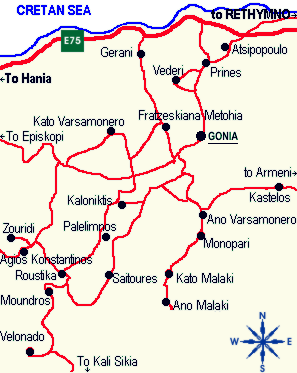
 The Municipality of Nikiforos Fokas is located in the north of Rethymnon Prefecture. It is bounded to the north by the Cretan Sea, to the south by the Municipality of Sellia, to the east by the Municipality of Episkopi and to the west by the Municipality of Rethymnon.
The municipality's jurisdiction extends over the fourteen former community wards of Agios Konstantinos, Ano Valsamonero, Atsipopoulo, Gerani, Gonia (Athanatos), Zouridi, Kalonyktis, Kato Valsamonero, Malaki, Mountros, Prines, Roustika, Saitoures and Frantzeskiana Metochia, which comprise a total of 21 villages.
All of the above villages have a long history and are known for their magnificent architecture; this is in no small part due to the Venetians, who inhabited the area from the 14th to the 17th century.
The municipality has a total area of 9600 ha. and a population of approximately 6700. Although excellent seaside resorts such as Gerani attract many visitors, the real charm of the area lies inland.
SIGHTS
First and foremost, the area is known for its outstanding natural beauty, including the following attractions:
Gorges:
- Frantzeskiana Metochia - Prines - Gerani - Gerani Cave.
Situated 12km from Rethymnon, this beautiful gorge runs seaward from Frantzeskiana Metochia to Gerani by way of Prines (Vederi), a total distance of 7km. Since there is no path, the route is only recommended for experienced walkers.
- Palailimnos - Saitoures
- Mountros
Caves:
Gerani cave.
Woodland :
The entire route from Atsipopoulo to Mountros (approx. 25 km.) passes through dense woodland.
Historical Tradition & Architecture
All of the municipality's settlements are steeped in history and contain fine examples of architecture, featuring stone buildings with vaulted entrances (known as "diavatika") and magnificent thresholds. This alone is reason enough for a visit to the Municipality of Nikiforos Fokas.
• Top
VILLAGES AND SETTLEMENTS:
ATSIPOPOULO
This village in the Municipality of Nikiforos Fokas is situated 5km SE of Rethymnon at an altitude of 160m.
Its existence is first testified in 1182, in the document which divided Crete up among twelve Byzantine nobles, whereby Atsipopoulo was assigned to the Chortatsis clan, a noble family of military tradition. It is also mentioned by Barozzi in 1577, by Kastrofilakas in 1583 and by Vasilikatas in 1630. In the Egyptian administration's census of 1834 it is referred to as Prines and Atsipopoulo, comprising 130 families.
By 1881 Atsipopoulo was the seat of the municipality of the same name, with approximately 850 inhabitants. In 1900 it is mentioned as having a population of 885, while by 1920 it had lent its name to a community of 684 people.
Atsipopoulo now has 973 inhabitants and lies within the jurisdiction of the Municipality of Nikiforos Fokas.
The strategic importance of the village gave rise to many battles during the Ottoman occupation and to its eventual destruction by the Turks in 1866; many villagers earned a reputation in this period as brave warriors. The village was also the birthplace of several important men of letters, such as G. Chortatsis, author of the Cretan Renaissance dramas The Sacrifice of Abraham and Erophili.
To this day Atsipopoulo remains one of the most beautiful villages on Crete, not least because the inhabitants were quick to realise the value of its architectural features.
These have been respected, preserved and made such good use of that the village retains the appearance and grandeur of Venetian times.
Visitors are sure to be enchanted by the neighbourhoods, with their courtyards and doorways bearing dates from the 17th and 18th centuries, as well as by the village's churches and other buildings.
Accommodation, dining and entertainment facilities are all available. In short, visitors attracted to Atsipopoulo are guaranteed to leave the area as the finest ambassadors Cretan tourism could wish for.
AGIOS KONSTANTINOS
This village in the Municipality of Nikiforos Fokas is situated at an altitude of 250m and has a population of 220. It lies 16km from Rethymnon, to the left of the old road to Chania via Atsipopoulo and Gonia.
The village's name is taken from the local church.
It is testified in Venetian censuses of the 16th and 17th centuries, while in the Egyptian administration's 1834 census it comprised 50 families. In 1881 it formed part of the Municipality of Roustika and had 263 inhabitants; by 1900 this number had increased to 345. Since 1928 it has formed a community in its own right.
Agios Konstantinos lies on a rugged outcrop. According to the Rethymnon archaeologist E. Lambrinakis, the tiled village square lies over the ruins of a mint.
Under Venetian rule it was a fief of the Barozzi family - to this day the village retains the overall appearance of that time.
Several fine houses were built during the period Agios Konstantinos served as a summer retreat for the Venetian nobles of Rethymnon. The drinking fountain erected by the Barozzi family can still be seen one mile to the east of the village. The municipal ward of Agios Konstantinos includes the Venetian settlement of Agios Georgios, lying at an altitude of 390m.
Ano Valsamonero
This village in the Municipality of Nikiforos Fokas is situated at an altitude of 380m and has a population of 144.
It lies 14km from Rethymnon on the Atsipopoulo road, turning left after Agios Andreas.
In all the Venetian censuses it is given as Varsamonero (from the aromatic balsam plant); the current spelling is the result of a mistake made in 1940.
It is twice referred to as part of the Municipality of Atsipopoulo, first in 1881 and again in 1900, together with Monopari. Since 1920 it has formed a community in its own right, in the same municipal ward as Monopari, which lies 1.5km south of Ano Varsamonero at an altitude of 380m.
As an old Venetian settlement, Monopari is mentioned in all the 16th and 17th century censuses. centuries. Its name is derived from the nearby Venetian fortress of Bonriparo or Belriparo, which was known locally as Monopari.
The fortress itself was founded or renovated in 1206 by the Genoan pirate leader Enrico Pescatore. In 1217 Pietro Filicanevo, castellan of the time, stole horses and other livestock from a Cretan noble named I. Skordilis. When the castellan ignored an order from the duke to return what he had stolen, Skordilis took even more than he had lost, thus provoking the Sivrites revolt (1217-1236).
E. Lambrinakis refers to Monopari as having been the castle of the Melissinos family, built in 1185 on a precipitous outcrop over the ruins of ancient Ionia. At an altitude of 800ft, it had a long Byzantine wall, three high towers and a marble gateway. There were no walls to the East and South, since these sides were protected by a precipice. Ruins of the wall and towers are still visible from the path leading to the entrance. The fortress affords a panoramic view over almost all of Rethymnon prefecture, Georgioupoli and the Cape of Chania (Akrotiri).
KATO VALSAMONERO
This village in the Municipality of Nikiforos Fokas lies 14km from Rethymnon at an altitude of 250m and has a population of 164.
It is given as Kato Varsamonero in all the Venetian censuses and in the Egyptian administration's census of 1834. The same name occurs in 1881 and 1900, when it is ascribed to the Municipality of Atsipopoulo. In 1920 it is referred to as being in the Community of Frantzeskiana Metochia, whereas since 1940 it has formed a community in its own right. From the time of Vasilikatas numerous local witnesses have reported that an intense light can be seen emerging from the Perdikis Chasm, which lies 1.2km west of the village, yet this phenomenon remains uninvestigated by speleologists.
Kato Valsamonero also boasts the Church of St. John (Agios Ioannis), famed for its exquisite wall paintings.
GERANI
This village in the Municipality of Nikiforos Fokas lies 7.5km from Rethymnon, following a left-hand juction from the new national road from Rethymnon to Chania.
Gerani is listed in all the Venetian censuses of the 16th and 17th centuries, as well as in censuses carried out by Egyptian and Ottoman administrations. In the censuses of 1881 and 1900 it is reported as belonging to the Municipality of Atsipopoulo, while by 1920 it was the seat of an agricultural municipality with 227 inhabitants. In 1928 it was ascribed to the Community of Prines, but since 1940 it has been a community in its own right. In an Ottoman document of 1672 it is referred to as part of the "vakuf" ("tied") villages serving the charitable institute of Sultan Ibrahim Khan.
The population of Gerani now stands at 502.
The village nestles among groves of olive, oak and carob trees, affording a view of the Cretan Sea. Every year its excellent facilities cater for numerous tourists.
A short distance away at Kamari lies the Gerani Cave, an important site in Minoan times.
GERANI CAVE
This cave was rediscovered by chance in 1969, during excavations for the construction of a bridge. It lies 2km NE of Gerani, 7km west of Rethymnon at Kamari, 300m from the shore.
Until its rediscovery the entrance had been blocked by a huge boulder which probably fell in an earthquake. Both the modern and ancient entrances face north.
The cave is 50m long, at a width of between 0.5 and 17m and a maximum height of 4.5m. Impressive rock formations are to be found within.
Excavations led by the archaeologist Ioannis Tzedakis revealed that the cave was in use as early as the Neolithic Age. It served as a place of worship and burial; both animal and human skeletons have been found. At the ancient entrance there is a staircase reminiscent of the type seen at Knossos, with eight steps, five of which are carved into the rock.
GONIA
Gonia is the seat of the Municipality of Nikiforos Fokas. It is situated on a hill affording a panoramic view, 11km along the old national road from Rethymnon to Chania via Atsipopoulo and Prines.
Gonia is mentioned in Venetian censuses carried out by Barozzi (1577) and Kastrofilakas (1583) and Vasilikatas (1630), as well as in the Ottoman census of 1671 and the Egyptian one of 1834. In the 1881 and 1900 censuses it is ascribed to the Municipality of Atsipopoulo, while in 1920 it is named as the seat of its own agricultural municipality; eight years later it was the seat of a community.
Today Gonia has a population of 400 and is the seat of the Municipality of Nikiforos Fokas. It is in the same ward as the village of Agios Andreas, a beautiful historic settlement containing fine examples of traditional architecture.
Best Car Rental in Crete
Search our reservation system for vehicles and dates and receive an instant online quote. Alternatively send us your request for a customized car hire arrangement
| Kiknos Studios , Kalamaki
Just on the water line of the sparkling deep blue waters of the Libyan Sea, -Open all year round - Air Condition
|
|
ZOURIDI
This village in the Municipality of Nikiforos Fokas lies 20km from Rethymnon, following the left-hand turn to Agios Konstantinos, 16km along the road to Atsipopoulo and Gonia.
Zouridi is a beautiful historic settlement, featuring buildings which have retained Venetian architectural features.
It is mentioned in the censuses carried out by Barozzi (1577) and Kastrofilakas (1583). It is ascribed to the Municipality of Roustika in 1881 and again in 1900, when it is given as Zouridi and Agios Georgios. Since 1920 it has been the seat of its own community.
The village has a population of approximately 100. The ruins of the Villa Barozzi are still visible, as is the Byzantine chapel of Christ the Saviour with its frescoes. The Venetian buildings in the village were included in Guiseppe Gerola's survey.
KALONYKTIS
This village in the Municipality of Nikiforos Fokas lies 15km from Rethymnon, following a left-hand turn after Agios Andreas, along the road to Atsipopoulo and Gonia.
Kalonyktis stands at an altitude of 270m.
It is mentioned by Barozzi in 1577 and Kastrofilakas in 1583, as well as by Chourmouzos Vizantios. In 1881 it is correctly referred to as Kalonykti in the Municipality of Roustika, with a population of approximately 125. In 1920 it appears as Kalonyktis in the agricultural Municipality of Palailimnos, with 152 inhabitants, while from 1928 onwards it has been a community in its own right.
The village currently has 180 inhabitants. It contains several examples of traditional architecture and Venetian buildings including a mill.
The parish church is of Byzantine origin and is dedicated to the Birth of the Virgin, the feast of which is celebrated on 8th September.
MALAKI
Ano and Kato Malaki are two villages in the Municipality of Nikiforos Fokas which lie at a distance of 4km from each other. Ano or Apano Malaki is situated 22km from Rethymnon at an altitude of 420m, while Kato Malaki is 18km from Rethymnon at an altitude of 360m. The left-hand juction leading to these villages is 11km along the old national road to Chania.
Malaki is listed in all the Venetian censuses of the 16th and 17th centuries. In the 1881 census the two villages are referred to collectively as Malakia in the Municipality of Roustika, with a total population of 170. Since 1920 they have formed a distinct community and are referred to separately.
N. Stavrakis believed the name Malaki had etymological roots in the Greek word for wool "malli" rather than mollusc "malakio", and thus spelled them Mallakia.
The traditional doorways in the village are well worth inspection. The area has several churches containing caves, including Agios Antonios and Agios Petros in the Bononidon Gorge.
The small mountain plateau of Potamia nearby is an oasis of plane trees and springs.
MOUNTROS
This village in the Municipality of Nikiforos Fokas lies 23km from Rethymnon at an altitude of 280m and has a population of 216.
The left hand junction leading to Mountros is 16km along the old national road to Chania, via Agios Konstantinos and Roustika.
The village is mentioned in all the Venetian censuses of the 16th and 17th centuries. In the 1881 and 1900 censuses it is ascribed to the Municipality of Roustika, with a population of approximately 370, while since 1920 it has formed a community in its own right.
Guiseppe Gerola recounts that he visited a Venetian house in Mountros which had an inscription taken from Virgil's Aeneid carved in the door lintel. The village is divided into two neighbourhoods, Panohori and Katohori, both of which have a drinking fountain.
Village churches include those of Agios Konstantinos, the 11th century church of the Agioi Anargyri and the parish church of Agios Nikolaos.
Two springs, named Komninovrysi and Chalase, are to be found at Pera Mountros.
The 1.5km long Mountros Gorge lies to the west of the village. The municipal ward of Mountros includes the village of Nisi, known for its fine stone buildings, and the small village of Velonado, lying at an altitude of 380m.
PRINES
This village in the Municipality of Nikiforos Fokas lies 7km along the old national road from Rethymnon to Chania at an altitude of 350m and has a population of approximately 450.
It is recorded by Barozzi (1577), by Kastrofilakas (1583) as "Prines and Dependencies" with a population of 430, and by Vasilikatas (1630). In the censuses of 1881 and 1900 the village is ascribed to the Municipality of Atsipopoulo, with approximately 520 inhabitants, while since 1928 Prines has formed a community in its own right. E. Lambrinakis refers to Prines as the birthplace of Markos Kaloudis, a member of the revolutionary "Holy Company" who distinguished himself in battle at Dragatsani and Frangokastelo. Kaloudis died in 1886, having left his entire estate to the District of Rethymnon, to fund the education of local born teachers.
The village is noted for its picturesque alleyways; other local attractions include the Bemboyiannis Mill and a traditional olive press.
The municipal ward of Prines extends to the small village of Vederi, known for its Venetian buildings. A magnificent stone threshing floor is visible to the right of the road linking the two villages.
The Church of Agios Antonios (1833), featuring icons by Ioannis Stathakis, is also well worth visiting.
ROUSTIKA
This village in the Municipality of Nikiforos Fokas is situated at an altitude of 290m and has a population of 310. Roustika lies 21km from Rethymnon, following the left-hand turn to Agios Konstantinos, 16km along the old national road to Chania via Atsipopoulo and Gonia.
The village is mentioned by Barozzi (1577), Kastrofilakas (1583) and Vasilikatas (1630), as well as in the Ottoman census of 1671 and the Egyptian one of 1834. In the 1881 census Roustika is given as the seat of a municipality of the same name, with approximately 440 inhabitants - thereafter it appears as the seat of a community. The village nestles among beautiful surroundings and resembles a miniature citadel when viewed from a distance.
The inhabitants of Roustika have long been known for their scholarly inclinations; over the centuries the village has produced several highly educated people. This is most probably due to the proximity of the Monastery of Profitis Ilias (Elijah the Prophet), which lies 1km north of the village. A school founded in 1875 by Chatzimichalis Angelidakis operated up to the end of the Ottoman occupation of Crete.
Under Venetian rule Roustika came within the tithe of the Barozzi family. A magnificent drinking fountain erected by the Barozzis can still be seen at Boutsounargia, on the road between Roustika and Agios Konstantinos.
Another local place of interest is the twin-aisled church dating from 1380. This is dedicated to the Dormition of the Virgin Mary and the Transfiguration; the aisle dedicated to the Virgin Mary is adorned with frescoes.
The municipal ward of Roustika extends to Palailimnos, a picturesque village situated in dense woodland at an altitude of 300m. The village can be reached by following the road left out of Roustika to Kalonyktis.
Ancient trees line an impressive gorge between Palailimnos and Ano Varsamonero. The Chapel of Agios Stephanos and the ruins of an impressive castle are both within easy reach.
Best Car Rental in Crete
Search our reservation system for vehicles and dates and receive an instant online quote. Alternatively send us your request for a customized car hire arrangement
| Die Zwei Brueder Pension, Matala
The name for Quality. Plenty of sun, good food, very welcoming people and we at DIE ZWEI BRUDER ...
|
|
SAITOURES
This village in the Municipality of Nikiforos Fokas is situated at an altitude of 350m and has a population of 186. Saitoures lies 25km from Rethymnon, following a left-hand turn towards Kalonyktis, Palailimnos and Roustika, 13.4km along the old national road to Chania.
The village is recorded by Barozzi (1577) and Kastrofilakas (1583). In the censuses of 1881 and 1900 Saitoures is ascribed to the Municipality of Roustika, but since 1920 it has formed a community in its own right. In 1630 Vasilikatas reports the existence of an Orthodox church dedicated to the Virgin Mary, situated in the middle of the village. This contained a silver-plated iron cross bound by an iron chain which was capable of curing the insane and the possessed.
FRANTZESKANA METOCHIA
This village in the Municipality of Nikiforos Fokas lies 12.5km from Rethymnon and has a population of approximately 239. It can be reached following a right-hand turn on the road to Agios Andreas via Atsipopoulo, Prines and Gonia.
There are two possible etymologies for the village's name: it was either a dependency of the Franciscan Order which had a monastery in Rethymnon, or of a Venetian feudal lord named Frangiskos.
The village is first testified in the Egyptian administration's census of 1834. In the censuses of 1881 and 1900 Frantzeskiana Metochia is ascribed to the Municipality of Atsipopoulo, but since 1920 it has formed a community in its own right.
• Top
Bibliography: Towns & villages of Crete by S.Spanakis
|


)
)
)
)
)
)
'))
)
)
)
)
)
)
)
)
)
)
)
)
)
)