interkriti®
YOUR GATEWAY TO CRETE
HOME
CRETE FACTS
NAVIGATE
EXPLORE

Agia Galini
Triopetra
Kissamos
Chryssi Isl.
Agia Marina
Balos
Gavdos isl.
Georgioupolis
SAMARIA
IDA Mtn
Palaiochora
Agia Roumeli
Sfakaki
Bali
Kalamaki
Matala
Lassithi
Plateau Lendas
Tsoutsouros
Vianos
Myrtos
Sfakia
Plakias
Ierapetra
Makrygialos
ZAKROS
Vai
Sitia
Agios Nikolaos
Elounda
MALIA
Hersonissos
Gouves
Chania
Rethymnon
Heraklion
GORTYN
FESTOS
KNOSSOS
|
|
Crete
List Grid Map
Found
115
- Showing :
21 - 40
 Malevizi, Iraklion at 15.4km (E) Ano Asites (GR: Ανω Ασίτες) lies 24km from Iraklion and 6km from Agios Myron at 480m a.s.l with 423 inhabitants. A big part of the surrounding area is covered by forest on the eastern side of the mountain Psiloritis. Near the village there is the Byzantine chapel of Agios Antonios located in the ravine with the same name a place of exceptional natural beauty. From here passes the European Hiking Path (E4) which leads to the shelter "Prinos" ( of the Mountaineering Club of Iraklion - altitude 1100 m a.s.l.) located in a holly (=prinos) forest.  Voroi, Messara, Iraklion at 15.5km (S) The exhibited objects in the Museum come from all over Crete. These objects show that the folk culture of Crete is characterized by an amalgam of influences in which Minoan (2000-1000 BC), Archaic (1000-500 BC) and Byzantine models prevail, especially in agriculture, stock breeding, pottery and basketry.
 Messara, Iraklion South at 15.9km (S) Vori is a beautiful, traditional village of the county of Pirgiotissas in the Messara Valley. It is located 60 km south of Iraklion and in the western part of the Messara Valley. The village stretches in a slope, by the side of a small river. The archaeological site of Phaistos is 2 km to the south and the coast of Messara 4 km to the west.
 Kenourgiou, Iraklion at 15.9km (E) Priniás (GR: Πρινιάς) is a small village located 35km southwest of Iraklion town and 4km from Agia Varvara, at a height of 610 m above sea level. The village of Prinias lies on the border of three regions: Malevizi, Kenouriou and Monofatsi, and is recorded as forming part of all three regions in the censi.  Mires, Messara Valley at 16km (S) It is located north of Mires close to a small gorge, with springs and covered with trees. There are many churches in the village the most important one being the church of Agios Nikolaos, a domed church dated to the 13th century. The walls of the temple are hand painted with biblical scenes and pictures of saints
 Messara, Iraklion South at 16.1km (S) The town of Timpaki (GR: Τυμπάκι) is located in the west edge of the plain of Messara, 65.3km away from the city of Iraklion. It is a rich and busy town with significant economic activity especially due to the early vegetables production in the wider area. There are banks, a post office, medical centers, stores, schools, hotels, restaurants, ect to cover both the needs of the locals and visitors.
 Messara bay, Iraklion South at 16.2km (SW) Kokkinos Pirgos (GR: Κόκκινος Πύργος) is a small coastal community, 2km away from Timbaki with a nice, long sandy beach, one of the longest in Crete, and a clear transparent sea. The part of the beach to the north west of the harbour is called Makrimaliana (or Kakoskalo) and the south east part of it is called Katalyki . The harbour in front of the village of Kokkinos Pirgos, offers docking facilities for sailing and fishing boats. There are hotels, restaurants, bars, etc. across the harbour and along the beach. You can always find good fresh fish in the taverns of the village. Kokkinos Pirgos (meaning red tower) , took its name from a castle that use to be there during the Middle Ages, which was built by red clay earth.
Image Library
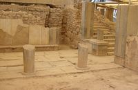
 Mylopotamos, Rethymno at 16.2km (N) Apladianá (GR: Απλαδιανά) is a small village built at the foot of the two Kouloukona heights. The settlement stretches out along the old national road, where it developed after the opening of the new national road. It comprises cafes, tavernas, and accommodation facilities included in the Countryside Tourism programs. It is worth your while, however, to visit the old village, climbing there on foot or by car. Picturesque, narrow streets, wonderful old houses with interesting architectural elements, old cisterns and churches will reward your efforts. The old village built on a height of 260 m above sea-level has 175 inhabitants and the settlement along the old national road, known as "Kampos ton Apladianon", has 78 inhabitants. It is 40 kilometres away from Rethymnon and is located at the foot of the highest peak of the Kouloukona mountain in the Tallaios range. Historical background Already as far back as 1368 we find a mention of the Aplada family, the founders of the present village and in the topographical maps of the Civil Engineering Services of Rethymnon it figures as Pladiana. The settlement is not mentioned in the 16th and 17th cent. documents. In the 1881 census, Apladiana is attributed to the commune of Garazo, with 57 inhabitants and in 1900 it is referred to as the Apladiana Commune which, together with the Cheliana settlement, had 153 inhabitants.  Archaeological Site in Messara, S-W Iraklion at 16.9km (S) The "Royal Villa" at Ayia Triada which is situated very close to Phaistos, was built in about 1550 BC. i.e. just before the new palace at Phaistos, and was destroyed by fire in l450 BC, like all other important Minoan centres. It succeeded the first palace at Phaistos as the economic and administrative centre of the regions depriving the new palace there of this role, and appears to have had connections with Knossos. The two wings, with an open-air space between them, consisted of groups of interconnecting rooms (polythyra), storerooms and stairways. On the site of the ruins, a Mycenaean megaron, the so-called "Agora" and an open - air shrine were subsequently built. In the villa's disaster layer from the fire in 1450 BC, excavation revealed a valuable group of exceptional works of art, precious materials, records in Minoan script and seals. The famous black serpentine vessels, the "Harvesters' Vase", the "Boxers' Vase" and the "Chieftain ‘ s Cup", the wall paintings depicting the natural landscape, the sarcophagus, the bronze and clay figurines of worshipers and the copper ingots from the Treasury are among the most noteworthy findings.  Malevizi, Iraklion at 17.3km (E) Pyrgou lies 20 km from Iraklion and 1km from Agios Myron at 400m a.s.l with 354 inhabitants. It is built on a hillside overlooking the area, with panoramic view to the village of Kroussonas and the ravine of "Agia Irini". At the village's perimeter there are well maintained tower-like houses.  Moires, Messara at 17.4km (S) The monastery of Panagia Kaliviani is located at the 59th km on the road Iraklion-Phaistos. The monastery was built during the second Byzantine period. The small Byzantine chapel was painted with frescoes but most of them are today destroyed. The chapel was deserted until, during the Turkish occupation in 1873, an old small icon of the Annunciation of the Holy Mother was miraculously found there.and the monastery became a place of worship. 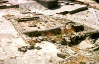 Phaistos Palace at 17.4km (S) The Upper Court is the first of the three courts in the West Wing of the Palace. Its south side is supported by a strong retaining wall separating it from the West Court. On the west side, the 17 circular recesses in the ground indicate the presence of an equal number of wooden columns which probably supported a covered colonnade. The court is crossed from north to south by a raised "Processional Causeway", which, like those of the other palaces, would have been used for sacred processions and other rituals. The Upper Court also functioned as a kind of balcony from which one could watch the events taking place in the West Court, which is just to the south and on a lower level. The two courts are linked by a majestic staircase starting in the southeast part of the Court. The buildings on the south side of the court were built much later, in Hellenistic times (323-67 BC), when the palaces had already beendestroyed. The most important of these contains a room with two columns, a central hearth and stone benches around the walls. It isbelieved to be a public building, probably a Prytaneion or Andreion.Early Christian tombs (330-600 AD) can be seen east of the "Processional Causeway" Image Library
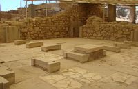 Phaistos Palace at 17.4km (S) The northernmost of the "Royal Apartments" has been identified as the King's Megaron and bears a striking resemblance to the corresponding "King's Megaron" at the Palace of Knossos. It consists of a spacious central hall with impressive polythyra (pier - and - door partitions) on the north and east sides. The east polythyron communicates with a second room with two columns, which opens onto a large light-well to the east. The gypsum slab flooring with red plaster filling, the interstices, gave the whole complex a particularly sumptuous air. The north side of both rooms opens onto a spacious colonnade with columns set far apart, offering a magnificent view of Mount Psiloritis and the sacred Kamares Cave. A long corridor at the back of the polythyron room leads to the impressive "Lustra1 Basin" of the Megaron. The whole apartment was decorated with colourful wall paintings depicting linear and plant motifs. Image Library
 Phaistos Palace at 17.4km (S) The southernmost of the "Royal Apartments" ofPhaistos has been identified as the Queen'sMegaron. It consists of a beautiful, spacioushall with a double colonnade opening ontoa light-well. The floors are paved with gypsum slabswith red plaster filling the interstices. Gypsumwas also widely used for the benches runningaround the walls of the Megaron and the facingof the lower part of the walls. The upper walls aredecorated with frescoes depicting plant motifs. Twobeautiful rhyta (libation vessels) were found here: one is decorated with the cult symbols of thedouble axe and sacral knot, while the other bears areed pattern. The two staircases to west and north led to the upper floorof the Megaron and the peristyle, where one of the mainentrances to the "Royal Apartments" was located. Image Library
 Phaistos Palace at 17.4km (S) The complex of four rooms on the northeast edge of the Palace does not belong to the Old Palace, although it directly adjoins it. In the westernmost building is an elongated rectangular room with partitions of vertical clay slabs. Similar "cists" in the Palaces of Knossos and Zakros were used to store valuable ritual vessels. Here they were found empty. Next door, in the narrow rectangular room to the southeast, was found a clay tablet inscribed in Linear A and the famous "Phaistos Disc" bearing hieroglyphic writing. The building was therefore named the Palace "Archive" The building east of the Archive is thought to be a shrine or the archivist's residence, while the easternmost building is known as the "Potter's Workshop" because a large number of unfinished pots were found there. The intermediate building has an impressive peristyle of alternating pillars and columns. A staircase on the south side of the peristyle building connects the whole complex to the NE entrance to the Palace, which stood in this spot. Image Library
 Palace and Archaeological Site at 17.5km (S) The archaeological site, the palace, the findings - The Festos Disc. According to mythology, Phaistos (or Festos) was the seat of king Radamanthis, brother of king Minos. It was also the city that gave birth to the great wise man and soothsayer Epimenidis, one of the seven wise men of the ancient world.Excavations by archaeologists have unearthed ruins of the Neolithic times (3.000 B.C.).
Image Library
 Found at Phaistos Palace at 17.5km (S) The disc of Phaistos is the most important example of hieroglyphic inscription from Crete and was discovered around 1903-05 in a small room near the depositories of the "archive chamber", in the north - east apartments of the palace, together with a Linear A tablet and pottery dated to the beginning of the Neo-palatial period (1700- 1600 B.C.). The disc of Phaistos can be seen at the Archaeological Museum of Heraklion. Image Library
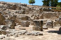
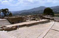
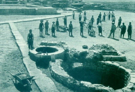
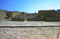 Phaistos Palace at 17.5km (S) The large paved West Court, in front of the facade and the central entrance to the Palace complex, dates from the time of the Old Palace (1900 - 1700 BC) and played an important part in the lives of its inhabitants. On the north it is bounded by a high which also supports the Upper Court, which is on a higher level. At the foot of the wall are eight wide steps which formed the seats of what may be called a theatral area. As with the corresponding "Theatre" of Knossos, from here spectators would have watched the religious events and festivals taking place in the court. The West Court is crossed by a raised "Processional Causeway" similar to that of the Upper Court, which continues up the steps of the Theatral Area. During the time of New Palate the West Court was widened and raised to a higher level, so only 4 of its 8 steps remained visible. After the reduction of the Theatral Area, the great staircase must have been used as an additional theatral area for the events and ceremonies held in the West Court. 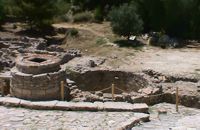 Phaistos Palace at 17.5km (S) The south end of the West Court is occupied by four large stone-built structures known as "Kouloures" (rings) ,belonging to the Old Palace complex. The workmen on Evans' excavation gave them their name when they were first discovered at Knossos. Similar pits were also later discovered at the Palace of Malia. Their exact use is unknoun, although today they are generally regarded as depositories for offerings from the Palace shrines, or granaries. In front of the Phaistos "Kouloures" passes a "Processional Causeway" which starts in the West Court. One of the "Kouloures" is cut across by a cobbled road built in later years. The well next to them belongs to the Hellenistic period (323 - 67 BC).
 Phaistos Palace at 17.5km (S) The main facade of both the Old and the New Palace looked onto the West Court, off which the official entrances to the Palace opened. The facade which can be seen on a lower level belongs to the Old Palace(1900- 1700 BC). It is indented according to the rules of Minoan architecture. The lower part of the walls is constructed of massive limestone blocks (orthostats). The entrance is set into a recess in the SW corner of the court. lt consisted of a monumental porch with a large central column from which a splendid corridor, paved with gypsum slabs, led to the Central Court. This old entrance is now interrupted by the buildings of the New Palace. Higher up and 7 metres further back is the facade of the New Palace (1700-1450 BC). It is constructed of large ashlars and also has deep indentations and protrusions. There are two entrances leading to the interior of the Palace. The main entrance is on the north and consists of a monumental staircase leading to the Propylaea. The other is deeply recesed and leads via a wide corridor to the Oentral Court, crossing the West Wing of the Palace |
|||
|
| |||


C
O
N
T
E
N
T
S
O
N
T
E
N
T
S