interkriti®
YOUR GATEWAY TO CRETE
HOME
CRETE FACTS
NAVIGATE
EXPLORE

Agia Galini
Triopetra
Kissamos
Chryssi Isl.
Agia Marina
Balos
Gavdos isl.
Georgioupolis
SAMARIA
IDA Mtn
Palaiochora
Agia Roumeli
Sfakaki
Bali
Kalamaki
Matala
Lassithi
Plateau Lendas
Tsoutsouros
Vianos
Myrtos
Sfakia
Plakias
Ierapetra
Makrygialos
ZAKROS
Vai
Sitia
Agios Nikolaos
Elounda
MALIA
Hersonissos
Gouves
Chania
Rethymnon
Heraklion
GORTYN
FESTOS
KNOSSOS
|
|
Crete
List Grid Map
Found
45
- Showing :
41 - 45
 Sitia, East Lassithi at 27.9km (E) The Monastery of Kapsa is located 40 km from the town of Sitia at the exit of the Pervolakia Gorge built against the steep rocks overlooking the Libyan sea. The exact time of the foundation of the monastery is still unknown, while some believe that it was in the 15th century. Until 1841 there were only a small chapel dedicated to the Saint John the Baptist and a few cells. Image Library
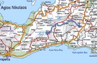 Richard Ellis walk: Day 3 at 29km (E) June 3rd - ...The short, direct, one marked with E4 signs ends in an olive grove with no way out ! You keep climbing on the basis that you will meet up with the Anavasi version of the route and then all of a sudden you find the dreaded stock fencing. I was lucky to find a way through (over) it, scramble up and over a ridge and see the easier, but longer, dirt road alternative on the other side of a full-flowing river. However, my choice of route seemed to be what the EOS expects you to do, as suddenly, and quite unexpectedly, there was another rare E4 sign on my side of the road on the way down to the river... Distance:24.7 km Time: 9 hrs. Mov av 4.3 km/hr Height overnight: 605m.(max 775 m.)  by Richard Ellis at 29.2km (NW) This was another delightful start to a day’s walking. Rather than tramping round the perimeter which is more or less where the E4 is supposed to go, it is quite possible to take a diagonal line from the south east corner to the north west corner by taking a right, then a left, then a right etc so you end up close to Kato Metochi. This way, you get to see close up the extent of the agricultural activity going on around the plateau in the morning sunshine. You also get to see the newly formed baby frogs – fresh from tadpole status – hopping happily in the sunshine in front of my big boots. Distance: 23.5 km Time: 7 hrs. Mov av 4.7 km/hr Height overnight: 335m.(max 824m.)  Mirabello, Lassithi at 29.6km (NW) Neapolis is located 15 km westwards of Agios Nikolaos on the way to Heraklion from where it is roughly 50 km far. Neapolis is built in the green valley of Mirabello. In the period of the Venetian domination its two settlements were named "New Village". But when the seat of the Prefecture was transferred from Fourni to the “New Village” this last was renamed to Neapolis. Neapolis was maintained as the capital of the prefecture of Lasithi till 1904. After that date Agios Nikolaos became the new capital.  Lassithi, Dikti Mountains at 29.8km (NW) The Lassithi Plateau (GR: Οροπέδιο Λασιθίου, Oropedio Lasithiou), is a high endorheic plateau, located in eastern Crete, Greece on the mountain range of Dikti at an average altitude of 840 m, and in a distance of around 55km from Heraklion and 50km from Agios Nikolaos. The plateau is elliptical in shape with an E-W axis of 11km and the N-S of 7km. The plateau of Lassithi is renowned for its exceptional agricultural produce, the thousands (almost 15000) windmills that used to be there in the past, its significant historical role and for the unique cave of Psychro also known as "Diktaion Andron". Image Library
|

|
|
|
| ||
C
O
N
T
E
N
T
S
O
N
T
E
N
T
S