Agiofaraggo (GR: Αγιοφάραγγο the gorge of Saints) is a small gorge at the southern shores of Heraklion close to the village and the beach of Kaloi Limenes and 6 kilometers south of the
Monastery of Odigitria.
The Aghiofarango Gorge is situated within the Pigaidakia Municipal Department, an area rich in natural, archaeological & historical and religious treasures. Amongst these, Lithino Cape, Lassea archaeological site, Kali Limenes, Apostolos Pavios (Apostle Paul) Cave, Odighitria Monastery with its Ksopatera Tower and the church inside Martsalo Cave, are most noteworthy.
Aghiofarango Gorge lies to the south of Odighitria Monastery and was born of the beds of two streams, one which begins at the north-northeast at Ghialomonochoro, and the other to the northeast, at Odighitria. The two streams meet near Aghia Kiriaki Church and following a gentle course to the west and then south of the church, end up at Porofarango, which marks the beginning of the Aghiofarango Gorge, which in turn leads to the Libyan Sea. A small yet enchanting beach frames the gorge's debouche.
The passage along the "Gorge of Saints" is one of the most beautiful in the area. Visitors have the choice of two starting points to reach it: either from Odighitria Monastery (one hour's walk) or from Aghia Kyriaki (a half an hour's walk). Most of the way down the Gorge, imposing rock formations with numerous caves tower-up on either side. Naturally isolated from the wider area's settlements —Aghiofarango is only accessible on foot— this proud landscape of wild beauty and unique atmosphere, ideally lent itself and quite fittingly developed into the first centre of ascetic life, not only in the area but in all of Crete, since the earliest Christian times.
The location's unique spirituality, beyond any description, is best rendered by its very name: Aghiofarango, the Gorge of Saints. Toward the end of the route, approximately 250 m before the beach, one comes across Aghios Andonios Church, which once was the area's religious centre, presumably where the first rites of the Christian faith were performed. It is believed that the church has undergone restoration works and/or additions on at least three occasions during its long history. To begin with, it was a tiny church inside a cave in the rock, but the steadily growing number of pilgrims and monks brought about its enlargement. The church outside the cave was thus built, but the altar remained within. The church was added to for the third and last time during the 14th or 15th century, remaining in this form to this day. Its architectural technique is exquisite and its interior used to be entirely covered with murals, which, alas, are no longer to be seen.
Outside the church stands a well, which was the only source of water in the wider area. To the south of the church, upon a small promontory, a desecrated circular domed Minoan tomb was discovered, thus bearing witness to human presence since the Minoan era.
A little further along the way, on the left hand side, is Ghoumenospilio Cave.
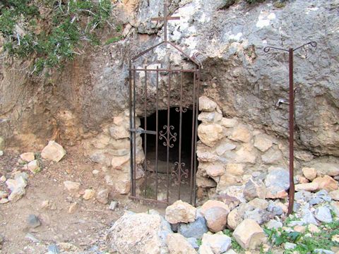
The entrance to Goumenospilios
In spite of its small and low entrance, it is a relatively spacious cave, with an open conical dome, approximately 9 m high and 7m wide. According to tradition, this is where the ascetic monks' gathering took place, once or twice a year. Each of them sat on a large stone, inside the cave. An "empty' stone at a gathering, told of a death in the community. The cave's proximity to the sea rendered it vulnerable to the ever more frequent pirate raids, forcing the monks to seek shelter elsewhere. According to the same tradition, the monks left the area and the cave and moved away to found the Apezanes Aghios Andonios Monastery, at a safe distance from the sea.


