interkriti®
YOUR GATEWAY TO CRETE
HOME
CRETE FACTS
NAVIGATE
EXPLORE

Agia Galini
Triopetra
Kissamos
Chryssi Isl.
Agia Marina
Balos
Gavdos isl.
Georgioupolis
SAMARIA
IDA Mtn
Palaiochora
Agia Roumeli
Sfakaki
Bali
Kalamaki
Matala
Lassithi
Plateau Lendas
Tsoutsouros
Vianos
Myrtos
Sfakia
Plakias
Ierapetra
Makrygialos
ZAKROS
Vai
Sitia
Agios Nikolaos
Elounda
MALIA
Hersonissos
Gouves
Chania
Rethymnon
Heraklion
GORTYN
FESTOS
KNOSSOS
|
|
Crete
:[u' Tourism & Leisure ']
List Grid Map
Found
567
- Showing :
461 - 480
 Kenouriou, Iraklion Doúli (GR: Δούλι) is a village in Kenouriou county, located 38 km from Iraklion at an altitude of 440 m above sea level. The earliest reference to it, is to be found in the Duke's Archives of 1372, where it is mentioned as the feudal property of Nic. Venerio. The name figures in all the Venetian censi of the 16th and 17th centuries, as well as in the Turkish (1671) and Egyptian (1834) censi. In 1881, Douli forms part of the municipality of Megali Vrisi with about 170 inhabitants, and again in 1900 with only 21 inhabitants. As of 1920, Douli is a commune in its own right, and today Douli has about 240 residents. The patron saint of the village is Aghios Panteleimonas and the feast of the Saint is celebrated on July 27th.A visit to the old church of Aghios Nikolaos is also a must. For those interested in paleontology, there are fossils to be found at the location 'Pirgos'.  Kenourgiou, Iraklion Moúlia (GR: Μούλια) is a village in Kenouriou county, located three and a half kilometers away from Agia Varvara town and 32 km from Iraklion at an altitude of 640 m above sea level. Moulia is an old village as we come across a reference to it in a document dated in 1248, where the settlement is recorded as belonging to the archbishopric of Crete. Another reference is found in a legal agreement established in 1411. The name figures in all the Venetian censi of the 16th and 17th centuries, as well as in the Turkish and Egyptian censi. In 1881, it forms part of the municipality of Zaros with about 180 inhabitants, and again in 1900. As of 1920 it is a commune in its own right, and today with the lower village of Kato Moulia it counts over 550 inhabitants. The main church of the village, with wall paintings, is that of the patron saints, Saints Peter and Paul, and there is a village feast on the 29th June, in their honour. The lovely chapel of Zoodochos Pigis is also well worth a visit.
 Gouves, Iraklion At a height of 140m. above sea-level, this village has 142 inhabitants and is 22.5 kms away from Iraklion. According to the villagers, the name comes from the church of Aghios Nikolaos Skotino at the entrance of a cave. It was built at the end of the Venetian period. Today an extra wing has been added, dedicated to Aghios Charalambos. This church of Aghios Nikolaos Skotino presumably functioned as a "Hedge School" (or "Hidden School") under Turkish rule when education had been banned. When the locals said: "We are going to Skotino (which also means "darkness")", they meant they were going to school. Turkish administration refers to this place as Skotino Perasma in 1671. Very close to the village (1.5 km) the cave of Aghia Paraskevi draws crowds of tourists and is well worth a visit.  Gouves, Iraklion Vorou (or Voritsi) lies at a height of 230 m. above sea-level and counted 62 inhabitants in 1981 and 48 in 2001. It is 25 kms away from Heraklion. To get there, you follow the National Road to Aghios Nikolaos and at kms 17.7 turn right, taking the road Gouves-Skotino- Vorou. Nowadays it is known as Voritsi but this name is not official. The name Vorou, on the other hand, in the district of Pediados is mentioned by Barozzi in 1577. At the beginning of this century there lived a wise man and a healer in the village of Voritsi. His name was Giorgos Konstantoulakis and people flocked from all over to Crete to seek his advice.
 Gouves, Iraklion At a height of 320 m above sea-level, Kalo Chorio (GR: Καλό Χωριό) λιεσ 25.7 kms. from Heraklion, to the right at the cross-roads at km 16.7 on the National Road to Agios Nikolaos and on the road to Gouves- Koxare- Kalo Chorio. The present name does not figure in old Venetian documents, though there is a reference in the 1367 Duke’s archives of Chandax to a Kalo Horio, without however naming the district. The villagers maintain that the village was called Stravorina in the old days, and indeed there is a reference by Barozzi in 1577 to a village Stravorina in the district of Pediados. In the 1583 Register, the village Stravorina is mentioned as having 76 inhabitants and in the Turkish census of 1671 Istavrine is quoted as having 21 "charatsa" (A Turkish word referring to a tax paid by the head of each family; hence 21 families). However, Chourmouzis Vizantios in 1842 mentions Kalo Chorio, the present name was therefore given in the decade 1830-1840. The village counted 298 inhabitants in 1981 which is also the current population. The Maza hill-top, south-east of the village, is 457 metres high. According to archaeologists (among them the famous N. Platon) and on the basis of recent finds, the name Maza comes from pre-Hellenic years and means Mother Earth. The pile of stones on the hill was, according to N.Platon, a town from the 10th to the 8th c. BC. The highest part was undoubtedly used as a shrine in Middle-Minoan years, and clay figurines and offerings were found there. The shrine lay quite close to the town. The shrine stopped being used in Proto-Geometric years. Northeast of the village, by the country road that leads from Kasteli to Hersonissos, traces of ancient installations have also been found along with remnants of water tanks by a source that is still in use today. These water tanks, probably belonged to Hersonissos aqueduct, parts of which are still visible today in Aposelemi valley. There is as well an interesting gorge close to Kalo Chorio, in the valley of Aposselemis river, worth seeing for nature lovers.  Pediada, Iraklion Krassi is a small village 47 Km's from Iraklion and 17 km from Malia at an altitude of 600 m.asl, on the way to Lassithi plateau, and is administratively part of the Municipality of Malia. The village is one of the prettiest in Crete, with a lot of springs. Due to the free running water , it is covered with walnut trees, plane trees and all kinds of vegetation. Next to the spring in the middle of the village is one of the oldest and biggest plane trees in Crete (its root has a circumference of 22 meters!). 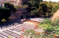 Iraklion Oasis is the part of the ditch of the new Venetian fortification that corresponds to the Rampant of Jesus. East of the entry of Oasis is the Cyprus square, roughly 600m from the centre of the city. For the first time, Oasis functioned as a small theatre during the 2nd world war when enough pines were cut. Then, up to 1963, a lot of assemblies took place here, mainly political. In 1963, the first serious effort of exploitation of Oasis as summer theatre, which was maintained up to 1976. In 1976 the theatre was created with the form that it has today. It became a modern open theatrical space of 1200 seats with all the necessary comforts.
 Hania old town An institution of culture, that aims in the creation of necessary "space", where the various sectors of Art, Science and Literature can coexist, each seeking the contribution of the other, thus becoming feasible the materialization of visions that each one of these means of expression of the Human spirit, to be able offer to the community. Address: 98-102, Chalidon Street, 73 131 Chania, Crete, Greece Phone number: +30 28210 92294 / +30 28210 36190 E-Mail: info@pinakothiki-chania.gr Links: Dimodiki Pinakothiki Hanion  Myrtia. Iraklion The Nikos Kazantzakis Museum is dedicated to the great Greek writer, poet and philosopher Nikos Kazantzakis. It was founded in 1983 and it is located at the village Myrtia in Iraklion, next to his father's house. The museum contains some of his personal belongings (pipes, glasses, pens, etc.) and a rich collection of his manuscripts and letters, first Greek editions of his books, documents from theatrical productions of his works, copies of TV series and movies based on his novels, portraits of Nikos Kazantzakis, copies of press releases and articles on his life and work.  Halepa, Hania After the scientific and administrative services of the Foundation "Eleftherios Venizelos" were transferred to the former Vloom Mansion, in 2005, the Venizelos residence remained the Foundation's headquarters and it has been converted into a Museum, a commemoration site for Eleftherios Venizelos. The residence bears the imprint of Eleftherios Venizelos and the building has maintained its original form, of the years he lived there. The furniture of the decade 1925-1935 was selected by Venizelos himself and his wife Elena, and was brought from Athens and abroad. Decorative objects and paintings of the period, original photographs and personal items of significant value decorate the interior of the residence. Website:www.venizelos-foundation.gr  Chania The aim of the Foundation is to function on a national level as a dynamic european research and educational centre constituting a central point of reference for the coordination of research into the work, era and life of the great statesman and more generally into modern Greek history without ideological constraints and preconceptions and without local limitations. The address of the Foundation is: National Research Foundation "Eleftherios K. Venizelos" House of Eleftherios Venizelos Elena Venizelou Square, Chalepa, 731 33 Chania T.K. 73133 Tel. (0030) 28210-56008, 51555-6, 54011 Fax (0030) 28210-56009 Email: info@venizelos-foundation.gr Office Hours: 08:30 - 16:00 Website:www.venizelos-foundation.gr  Chania The village of Mournies is a principal village, located 3.8 km south of Hania at 40m a.s.l. It took the name "Mournies" from the numerous mulberry trees, that use to be here even today. At the beginning of the 17th century, Mournies was famous for its beautiful villas, belonging to local noblemen. One of them, located southeast of the village, was the imposing three storey villa of "Koukounara". It had beautiful flowery gardens, fountains, statues ..., a real paradise, where many famous persons were received hospitality, amongst them the glorious Mme Ortans, the empress Eugene of Napoleon the third, queen Olga of Greece, and the king Constantinos in 1913. The villa today, being restored, houses a department of the Geek Navy. Mournies was the birth place of one of the greatest statesman of the new Hellenic Republic, Eleftherios Venizelos. Venizelos' influence on the history of Greece was paramount, from his participation to the talks with the Ottomans that resulted to granting Crete independence in 1897, to the final union of Crete with Greece in 1913. The house of Venizelos located in Mournies is going to be a museum, and many personal items of the politician are going to be on display there.  Chania Thérisso (GR: Θέρισο) is a small village, built on the foot of the White mountains, at 580 m a.s.l, 20km south of the city of Hania. It has 156 inhabitants and it is famous for its physical beauty, its diary-farming and its glorious past. You can reach Therisso from Perivolia passing through the Canyon (good asphalt road), or from Drakona, crossing the 7km dirt road through the forest. From here starts the trekking path which leads to the highest peak of the White mountains, Pahnes (2452m) Due to its location Therisso played a significant role at the history of the island especially during the 19th Century. A mill's stone located at the entrance of the village reminds the death of a young woman (grinded alive), when she denied to surrender to Mustafa Pasha. Here were born the great Cretan revolutionaries (Hainis), Vassilis, Giannis and Stefanos Halis. Vassilis Halis, became a hainis very young, and participated to the most great battles against the Turks in Crete and Peloponnissos. He was lt General when he died at Nafplion (Peloponnissos) in 1846. But Therisso is mostly known for its relation with the Venizelos movement in March 1905. Venizelos, who dissented with prince George' policy and declared the Union of Crete with Greece, had his headquarters at Therisso. The house of Venizelos is today a museum. The visitor to Therisso will admire the natural beauty, learn a lot of the history of the place listening to various stories and looking at the historical monuments, and taste the local specialties at the lovely taverns of the village. 2,5 km north of Therisso, at the left bank of Kladissos river, there is a cave where signs of neolithic and Minoan habitation were discovered. It is believed that it was a worship place.  Kydonia,Chania Within a few distance from the village of Perivolia, starts the gorgeous canyon of Therisso (Theriano faragi or Eleftherios Venizelos Gorge), which leads to the village of Therisso at 580m a.s.l. Six kilometers long, the gorge stretches like a snake, with high, almost vertical walls, and rich flora and fauna.It was a difficult to trespass gate, for the invaders, and that is the reason why Therisso was the center of the Cretan rebels during the 19th Century. The authorities has recently renamed the gorge, giving to it the name of the great Cretan statesman, Eleftherios Venizelos, who's name is strongly related with the area. The Crete Golf Club Hersonissos, Pediada 18 holes in a desert course design. Each hole individually sculptured, seamlessly blending into the existing landscape...The new Bob Hunt masterpiece (head of design at the PGA Golf Management Ltd of Great Britain), is best described as a desert golf course hewn out of rolling landscape little more than half an hour from the international airport of Heraklion. It boasts a series of memorable holes that will test every aspect of a golfer's repertoire and offers stunning views over mountainous landscape that has hardly changed since the Minoan era back in 2600 to 1100 BC. 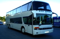 Heraklion Port Crete Public Bus Services (KTEL) with modern air conditioned buses and experienced personnel, offer travelling people, secured, comfortable, quick & affordable transportation almost to the most remote spot of the island. The bus station at Iraklion is situated at the port only a few minutes walk from the town's center. Timetables : East Crete Timetables-KTEL Heraklio - Lassithi West Crete Timetables-KTEL Hania - Rethymnon  Village in Messara plain Mitropoli (GR: Μητρόπολη) is a small village in the archaeological site of Gortyna in Messara plain. The village is mentioned for the first time in the Ducal archives of Candia in 1368 and later in the census of 1577 by Fr. Barozzi and in 1583 by Castrofylaka. Early mention of the settlement is to document the Ducal Archive of Candia in 1368, also mentioned by Fr. Barozzi in 1577 with the name and the Mitropoli Kastrofilakas in 1583. According to the census of 2001 it has 382 inhabitants. Main occupations of the inhabitants is the cultivation of vines, olives, vegetables, cereals and citrus fruits. At its north borders are located the ruins of the first cathedral of St. Titus, in which it owes its name.(Mitropoli = Cathedral). Image Library
Population of Crete Census 2001 Crete Region 303.871/ Prefecture of Iraklion 147.886 / Prefecture of Lassithi 38.239 / Prefecture of Rethymnon 41.123 / Prefecture of Hania 76.623. The population of Cretan municipalities men/women and map of population density...  Hania Institute dedicated to postgraduate and specialised education, applied research and the development of Mediterranean agriculture. MAICh offers postgraduate programs in the following fields: Business Economics and Management, Geoinformation in Environmental Management, Horticultural Genetics and Biotechnology, Food Quality and Chemistry of Natural Products and Sustainable Agriculture.  Hania The Institute for Olive Tree and Subtropical Plants of Chania is one of the Institutes of the National Agricultural Research Foundation (NAGREF), located at Chania, Crete, Greece. The Institute consists of 10 Laboratories, with research activities focused on the following fields: Oliviculture and Post-harvest Physiology, Citriculture, Subtropical Plants, Irrigation and Water Resources Management, Plant Mineral Nutrition and Physiology, Entomology, Plant Pathology, Food Technology, Hydroponic Culture and Aromatic Plants, and Animal Production. The research activities of the Institute are supported by modern facilities, including fully equipped laboratories, glasshouses, 50 ha of experimental fields and collections of genetic material for olive, citrus, subtropical plants and grapevines. |
||
|
| ||


)
';top.fotoWin('/dbsf/pages_pics/15/1522205/aposselemi_gorge01.jpg','');)
)
)
C
O
N
T
E
N
T
S
O
N
T
E
N
T
S