interkriti®
YOUR GATEWAY TO CRETE
HOME
CRETE FACTS
NAVIGATE
EXPLORE

Agia Galini
Triopetra
Kissamos
Chryssi Isl.
Agia Marina
Balos
Gavdos isl.
Georgioupolis
SAMARIA
IDA Mtn
Palaiochora
Agia Roumeli
Sfakaki
Bali
Kalamaki
Matala
Lassithi
Plateau Lendas
Tsoutsouros
Vianos
Myrtos
Sfakia
Plakias
Ierapetra
Makrygialos
ZAKROS
Vai
Sitia
Agios Nikolaos
Elounda
MALIA
Hersonissos
Gouves
Chania
Rethymnon
Heraklion
GORTYN
FESTOS
KNOSSOS
|
|
Crete
List Grid Map
Found
155
- Showing :
101 - 120
 Ierapetra, Lassithi at 23.4km (SE) A small village built at an altitude of 540 m in the south parts of the mountain Dikti at the borders of the province of Ierapetra-Viannos. The imposing mountains above the village, the south horizon among the olive-covered hills and in the lower villages, the cool climate create in you a sensation of bodily and spiritual well-being at this balcony of the Cretan nature. Five settlements, two of them uninhabited today, constituted the Community of Riza, now a Local Department of the Municipality of Ierapetra.  Knossou Av. Iraklion at 23.7km (NW) The General Hospital of Heraklion "Venizeleio & Pananio", named after the great statesman Eleftherios Venizelos, is one of the largest hospitals in Crete with 500 organic beds. It is located 4km away from Heraklion center on the road to Knossos, and occupies an area of 25,000 sq. meters. Venizeleio hospital provides high quality health services to citizens in a friendly and human environment. It was established in 1953 by a donation of Cretans of America and worked initially for Pulmonary Diseases. It was for many years the major hospital in East Crete. Telephone: (+30) 2813 408000 Website: www.venizeleio.gr/  by Richard Ellis at 24km (W) 10th June- I packed up the tent early after a noisy night of competing dogs and was on the road by 0615. After 3 or 4 kilometres on a mix of dirt roads and tarmac roads, I managed to find the concrete road which is the official E4 (marked with paint on a concrete watertank) up from Pirgos and a couple of hours later I was in Venerato having a frappe in the café by the turn to Kerasia.. Distance:35.8km Time: 13.75 hrs. Mov av 3.9 km/hr Height overnight: 945m. Max. height: 1600m  Ierapetra, Lassithi at 24.6km (SE) Deep inside the valley of the river Sarantapihos is built the village Mythoi. It is 22 km away from Ierapetra, it is a small village, in a verdurous landscape,with a beautiful square under the shade of age-old planes. It is said that the village took its name from the plant “Minthi”, or mint, which is abundant there.However, it may have been named thus because of its many legends, traditions, and myths (mythoi), the most prevalent one being the Sarantapihos’ one. A mythical giant, forty ells tall, like another Talos or Akritas Digenis, he protected the residents from raids. There are the place names “Tou Sarantapihoui Patounia” (Sarantapihos’ footprint) and “Tou Sarantapihou to Mnima”(Sarantapihos’ grave). There is evidence of ancient habitation at the site “Leniko” where traces of walls can be seen. Also, in an excavation, the head of a woman of the Roman period has been found. At the sites Kastelou Haraki and Orfanou to Spiliari claypots, oil lamps, e.t.c. have been found. The site called Sarakina above Mythoi was a fortress, a hideout of Saracen pirates. The village’s modern history is rich in contributions to the struggles against the conquerors. It nurtured the chieftains Emmanouil Xenikakis, Ioannis Hatzakis, Emmanouil Christakis andothers. During the German Occupation, residents of Mythoi took part in the guerilla corpses of the United Resistance of Captain Bantouvas. In the battle of Symi, one of the most heroic figures was lost, Apostolos Vagionakis, who stood up to the enemy’s bullets for the ideals of our unsubdued Crete. They paid the price of their participation to the struggles during the German Occupation,as 4 persons were executed, including the old and bedridden Nikolaos Ioannou Christakis. The community of Mythoi is today a Local Department of the Municipality of Ierapetra, in 1900 it had 360 Christian residents, in 1951 it had 423 and in 2001it had 287. In the north of Mythoi, around 6 km away, there is the settlementKarydi with the famous Monastery of Panagia (Our Lady) Karydiani and now abandoned summer residences. The mountainous settlement “Minos”, which is situated in a verdurous small plateau below the Afentis peak of the Lasithi mountains, also belongs to the Community of Mythoi.The village Mythoi is a lively village with a rich social and cultural life. It has a cultural association, a football team and field, and a modern olive press. The village’s square with its old plane trees, the mulberry trees, the old fountain,the traditional coffee-houses with the raki and the local dishes, is a place of reference for the residents of Mythoi. The sights, the wild natural landscapes in the north of the village, the famous gorge of Sarakina, a monument of natural beauty, attract a lot of local and foreign visitors. The gorge of Sarakina is one of the most beautiful in Crete. Its steep, vertical sides cause awe, and reach a height of up to 250 m. Its widest opening is no more than 15 m while in some places it’s so narrow that its sides seem joined. Its rich flora and fauna, dittany,the wild birds that nest there and the route inside the gorge are breath-taking. Its promotion is a foremost goal of the Local Department and the Municipality of Ierapetra, of the residents of the village, who head to the future with optimism and anticipation for the development of their place. Source:The Municipality of Ierapetra.  Ierapetra, Lassithi at 24.7km (SE) A stately village built in settlements, 22 km away from Ierapetra, at an altitudeof 225 m, next to the Ierapetra-Vianos provincial road. A green landscape,overgrown with olive trees, with an unlimited view of the Libyan Sea, to thesurrounding areas Koleitos, Kakon Oros, to the beaches Vatos and Kallikovrechtis.An almost abandoned village, with old houses built of stone, with chiseled doorframes and coats of arms bearing the Christian cross and proving its old gloryand history.Giannis Dimitromanolakis, an author from Gdohia, writes:“Gdohia sprouted right opposite the beach of the Libyan Sea. Nothing wouldhave been better for the pirates, who, like diabolical ghosts, emerged into thenight to kill and prey. The village’s history is dipped in blood, as it often sufferedfrom the raids of the pirates from the Barbary Coast. It took the name Gdohiafrom the catastrophes, from the verb “gdyno”, to skin, to set fire, to devastate.”Gdohia’s course in time has evidence of struggles, sacrifices and holocausts toshow. It was not only exposed to the pirates but it was situated on the naturalsouth passage going from the Viannos area to the Ierapetra area. This meantthat the hordes of barbarous conquerors burnt and devastated it, along withthe other Symiana villages, as they are called, in the West Ierapetra.Gdohia’s settlements are built leaving a distance between each other: KatoGdohia or Pitropiana, taking their name from the Epitropakis family livingthere, Pefkiana or Grysboliana, from the Grysbolakis family, Dimitromanolianafrom the Dimitromanolakis family, Daskaliana from the Daskalakis family,Papadiana from the Papadakis family. Great stonecutters, stoneworkers,famous for their art, Gdohia’s residents built the mansions of the whole areaand the famous bridge of Myrtos using stones from the quarries of Kolleitos.The miraculous church of Panagia (Our Lady) Evaggelistria of Gdohia, a workof art and a great ecclesiastical monument is also built by Gdohia’s residents.Gdohia village, once the seat of a Community, today a Local Department ofthe Municipality of Ierapetra, presents an exceptional sight-seeing interest. Itprovides natural landscapes, beautiful beaches, picturesque little churches onthe hills, a spacious square with palm trees, seats and a war memorial forthe fallen fighters of the liberation wars. In the 1881 census, 296 residents areregistered and 73 in 2001. Gdohia’s permanent residents, along with someforeigners’ families who have bought and renovated old houses, struggle forthe village’s development which gradually acquires the necessary infrastructures.A village with rich history and civilization, with vast olive groves, a nicemild climate, both during summer and winter, it hopes to come back to life.The old mansions, half-wrecked and burned in the German Occupation, standas if they were sculptures, a painting with the deep blue Libyan Sea serving asa background, narrate the flourishing, the glory and the history of Gdohia andwait to be inhabited again.
 Ierapetra, Lassithi at 24.8km (SE) Mournies (GR: Μουρνιές - meaning: mulberry trees) is a village of the western Ierapetra. It is located north of Myrtos, and 25 kilometers away from Ierapetra at 275m (elevation), built on the southeastern outskirts of the Lasithi mountains, with beautiful views of the Libyan Sea and the plains of Ierapetra. It has a mild climate, without extremes, ideal both for permanent residence and for holidays. The landscape is hilly plenty of olive trees. In the 2001 census it had 83 residents. Mournies is a beautiful, historic, picturesque and traditional village with cafes, a square with a war memorial, an old fountain, and narrow streets branching off the main street of the village. Mournies was named after the Mulberry tree which however is not abundant in the area.  Iraklion ( Nea Alikarnassos) at 24.9km (NW) Heraklion International Airport, "Nikos Kazantzakis" (Greek: Κρατικός Αερολιμένας Ηρακλείου, "Νίκος Καζαντζάκης") or Nikos Kazantzakis International Airport (IATA: HER, ICAO: LGIR) is the primary airport on the island of Crete, Greece. It is located about 5km from the main city of Heraklion. Heraklion International Airport is is one of the biggest in Greece and receives approximately 15% of the total tourist traffic of Greece. There are many airlines currently operating flights from Athens and Thessaloniki to Iraklion (Olympic Airways, Aegean Airlines and others), while during the high season there are flights from/to Rhodes, Mykonos, Santorini and other Greek islands. There are also international airlines that connects Iraklion to other European cities. During the summer season there are numerous chartered flights to Iraklion from all over Europe (mainly Germany, the United Kingdom, Russia, and Holland). During the summer months there is a huge increase in air traffic that peaks in August (approximately 130 flights per day). Major car-rental companies have desks at the airport. Taxi and public bus are available for transfer from/to Iraklion.  Mirabello, Lassithi at 25.3km (NE) Neapolis is located 15 km westwards of Agios Nikolaos on the way to Heraklion from where it is roughly 50 km far. Neapolis is built in the green valley of Mirabello. In the period of the Venetian domination its two settlements were named "New Village". But when the seat of the Prefecture was transferred from Fourni to the “New Village” this last was renamed to Neapolis. Neapolis was maintained as the capital of the prefecture of Lasithi till 1904. After that date Agios Nikolaos became the new capital.  North - Central Crete at 25.7km (NW) Iraklion (Heraklion or Herakleion GR: Ηράκλειον) is the largest urban centre in Crete, the capital of the region and the economic centre of the island. The first European civilisation, the Minoan civilisation, flourished on this land 5000 years ago. Currently the population of Iraklion is approximately 150.000 people. It is a very dynamic and cosmopolitan town, particularly during the summer period when thousands of visitors can be seen shopping in the market or visiting the museums and other places of interest. Today Heraklion is the top choice for tourist destinations in the Mediterranean. The city is also the commercial and scientific centre of the island. During the last 20 years the city has made remarkable progress in the academic and technological fields...
Image Library
 Kenouriou, Iraklion at 26km (W) Doúli (GR: Δούλι) is a village in Kenouriou county, located 38 km from Iraklion at an altitude of 440 m above sea level. The earliest reference to it, is to be found in the Duke's Archives of 1372, where it is mentioned as the feudal property of Nic. Venerio. The name figures in all the Venetian censi of the 16th and 17th centuries, as well as in the Turkish (1671) and Egyptian (1834) censi. In 1881, Douli forms part of the municipality of Megali Vrisi with about 170 inhabitants, and again in 1900 with only 21 inhabitants. As of 1920, Douli is a commune in its own right, and today Douli has about 240 residents. The patron saint of the village is Aghios Panteleimonas and the feast of the Saint is celebrated on July 27th.A visit to the old church of Aghios Nikolaos is also a must. For those interested in paleontology, there are fossils to be found at the location 'Pirgos'.  Mirabello, Lasstithi at 26.8km (E) Kritsa is one of the most picturesque towns in Crete, built amphitheatrically on a rock hill. It is located 11 km from Agios Nikolaos and has 2000 inhabitants. The people keep the old Cretan customs and the traditions and the town is considered one of the most important centers of the Cretan folk and weaving art.
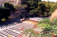 Iraklion at 27.1km (NW) Oasis is the part of the ditch of the new Venetian fortification that corresponds to the Rampant of Jesus. East of the entry of Oasis is the Cyprus square, roughly 600m from the centre of the city. For the first time, Oasis functioned as a small theatre during the 2nd world war when enough pines were cut. Then, up to 1963, a lot of assemblies took place here, mainly political. In 1963, the first serious effort of exploitation of Oasis as summer theatre, which was maintained up to 1976. In 1976 the theatre was created with the form that it has today. It became a modern open theatrical space of 1200 seats with all the necessary comforts.
 Iraklion at 27.2km (NW) The Emmetropia Mediterranean Lasik Eye Clinic, a private-sector ophthalmic surgery clinic, offers advanced vision correction in a patient-centered environment. Access to conventional and cutting-edge refractive surgery technologies such us Lasik, Lasek and more, for a wide range of vision problems, enable our physicians to optimize results by meeting each patient´s individual needs. 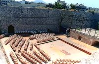 Iraklion at 27.2km (NW) Behind the "N.Kazantzakis open theatre", in the low square of the Gate of Jesus, was made after the proposal of Manos Hatzidakis and the design of Dionysis Fotopoulos, the Small Open Theatre, that recently named after the famous composer. It is constructed in a way so that is not caused damage in the Venetian Walls, that have been characterized as preservable monuments. In the "Manos Hatzidakis open theatre" (400 - 450 seats), as in "N.Kazantzakis open theatre" a lot of important events took place during the Heraklion Summer Festival. 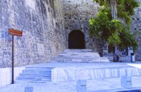 Iraklion Old Town at 27.2km (NW) The Gate of Agios Geórgios (GR: Πύλη Αγίου Γεωργίου - Saint George also called the Gate of Maroula or Lazaretto) was one of the central gates of Chandax during the Venetian period. Today it connects Eleftherias Square with Ikarou Avenue and at the same time is used as an exhibition venue. The gate used to lead towards the eastern provinces of the city, the Maroula suburb and the Lazaretto. Designed by Giulio Savorgnan and dedicated to St. George, the monumental city side facade featured a relief medallion of the warrior saint on horseback, set directly above the finely carved stones that formed the main portal. This monumental facade was demolished in 1917 for the opening of today’s Democratias Avenue. Of the gate today, its entrance towards Ikarou Avenue is preserved, the internal domed hall and part of its climbing arcade which have been restored by the Municipality of Heraklion.  Heraklion city at 27.3km (NW) The most magnificent collection of Minoan art and culture in the world, unique in beauty and completeness is housed in this museum. The exhibiton of the museum is organized in chronological order, ranging from the Neolithic period to the Roman era (4th century A.D.) and geographically, according to the provenance of the finds.
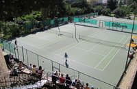 Iraklion at 27.3km (NW) The Club was founded in 1928 by Stelios and Stefanos Perdikojiannis, Meletis Kokkinakis, and Nikos Pandelakis. Until 1940 it was operating as an independent part of the Union of Athletic Associations of Iraklion, having Mr George Voiolas as president. In 1946 it became an independent club under the name "Tennis Organization of Iraklion" , commonly "TENNIS", with department of tennis and table tennis. Later in 1968 two more departments were added, basketball and volleyball, and finally the department of chess in 1978. In 1975 the club was renamed to "Iraklion Sports Club". Today the most active departments are: Basketball, Tennis, Table tennis, Chess. Links: Official Site  Iraklion at 27.3km (NW) The bastion heart shaped in plan with an acute angle, has two "piazza bassa" and one cavalier. It defines the southeast and the highest part of the fortification. Its name is due to Gabriele Tadini Martinego (1520) who started the construction of a circular tower at the place of the later bastion. It was one of the strongest bastions (the others were that of Pantocratora and that of Vittouri) which also suffered the main attack and most of the bombardment from the Turks. On the top of the bastion itself there was made a cavalier (which looks like a smaller bastion), whose main purpose was the better defense and control of the area around the bastion. The grave of Nikos Kazantzakis, the famous Cretan writer, is situated on the highest point of the Venetian fortification at the Martinego cavalier. The inscription by the wooden cross reads: " I hope for nothing. I fear nothing. I am free ", a phrase taken from "The Odyssey" which Kazantzakis considered as one of his most significant works. The playgrounds of the Academy of the local football team "Ergotelis" are located today on the main bastion and in the ditch around the bastion are the botanical gardens of the city. Image Library
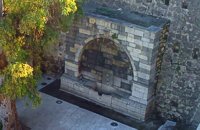 Iraklion Old Town at 27.3km (NW) It is next to the external Gate of St. George, underneath the statue of Eleutherios Venizelos. Within an arched construction, which its top is decorated with floral elements, there is a plaque and the spout is within a relief decorated frame. The water was collected in a marble basin of a similar decoration.
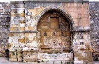 Iraklion at 27.3km (NW) It is in the Ikarou Avenue, next to the Epigraphic Collection of Heraklion Museum. Within an arched construction which, is surrounded by two big square columns, decorated with rosettes, there is a relief spout of fine workmanship. The water is gathered in a marble basin adorned by a richly decorated relief. Image Library
|
||
|
| ||


C
O
N
T
E
N
T
S
O
N
T
E
N
T
S