interkriti®
YOUR GATEWAY TO CRETE
HOME
CRETE FACTS
NAVIGATE
EXPLORE

Agia Galini
Triopetra
Kissamos
Chryssi Isl.
Agia Marina
Balos
Gavdos isl.
Georgioupolis
SAMARIA
IDA Mtn
Palaiochora
Agia Roumeli
Sfakaki
Bali
Kalamaki
Matala
Lassithi
Plateau Lendas
Tsoutsouros
Vianos
Myrtos
Sfakia
Plakias
Ierapetra
Makrygialos
ZAKROS
Vai
Sitia
Agios Nikolaos
Elounda
MALIA
Hersonissos
Gouves
Chania
Rethymnon
Heraklion
GORTYN
FESTOS
KNOSSOS
|
|
Crete
List Grid Map
Found
46
- Showing :
1 - 20
 Archaeological site in Malia, Iraklion The Palace of Malia, which covered an area of 7,500 sq.m. , was the third- largest of the Minoan Palaces and is considered the most "provincial" from the architectural point of view. The first Palace was built in 1900 BC and destroyed in 1700 BC when a new Palace was built. Following the fate of the other palaces in Crete it was also destroyed in 1450 BC. and the present ruins are mainly those of the new palace.
 Pediada, North - East Iraklion The most popular tourist resort in Crete. Nice beaches, sights and facilities for all tastes and ages. Together with Malia, are the party places for young visitors. Close to Hersonissos there are three small traditional village, those of Piskopiano, Koutouloufari and Old Hersonissos.
 Pediada, North - East Iraklion The famous tourist resort with all types of accommodations. Great beaches and a lively party atmosphere particularly in August. Becomes pretty quiet and peaceful during the rest of the season and there is a nice and picturesque part of the old village that preserves the traditional character. Malia has also a significant agricultural production and is famous for its bananas, potatoes and bottled water.
 Gouves Beach, North - East Iraklion Káto Goúves (GR: Κάτω Γούβες or simply Gouves) is a modern tourist resort with a complete tourist infrastructure to meet all demands. Organised beaches, large modern hotels, family apartments, restaurants, small tavernas, recreation centres, sports centre, shops, car and motorbikes for rent, small ports (marinas) for small boats, in a word Kato Gouves provides everything the visitors require to spend an agreeable and carefree holiday, enjoying the sunshine by day and the thrilling night-life in the numerous bars in the area. Just a few kilometers inland there are picturesque traditional villages, historic monasteries, caves and other natural beauties. Image Library
Kalyva Tavern Malia beach road Traditional Cretan tavern since 1964. Next to Malia archaeological site. In 1964, David Koulouras built a wooden shed by the seaat the "Potamos" area, where he offered the locals and tourists a simple meal and a place to rest in the shade. Today, two generations on,we hope to welcome you with the same Cretan hospitality and the same pure cooking as Mr. Koulouras did back then  Gournes The CretAquarium - Thalassocosmos (GR: Θαλασσόκοσμος) was officially opened in December 2005. It provides its visitors with a special experience, a trip to the underwater world of the Mediterranean Sea and its creatures. It is a unique park whose focus is on science, education, culture and recreation and whose goal is to promote, share and spread knowledge concerning the marine environment. Image Library
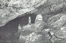
 Skotino,Gouves, Iraklion This is one of the three largest caves in the prefecture of Heraklion. It lies at half an hour distance to the north-west from the village of Skotino and is at a height of 225 m. above sea-level. The entrance to the cave is impressive: a large arch, 27 m wide and 10 m high. To the right one can see the ruins of an ancient chapel on which the modern chapel dedicated to Aghia Paraskevi was built. There is a feast held in front of the chapel on July 26th .
 Kasteli, Pediados The ancient city of Lyktos or Lyttos (GR: Λύκτος / Λύττος) was one of the most ancient and powerful towns in Crete. Although the excavations in the area reveal traces of habitation from the Hellenistic years onwards (630 B.C.), the archeologists Georgios Rethemiotakis and Angeliki Lempesi have excavated traces of habitation from the time of the destruction of Lyttos by the Knossians (219 B.C.) in excavated residences of the Hellenistic period. From the Roman period, the city was subject to new workings as testified by the architectural remnants and the many inscriptions and statues discovered. Numerous vestiges of ancient structures, objects, and broken marbles are seen, as well as an immense arch of a Roman aqueduct, by which the water was carried across a deep valley by means of a wide marble channel. Traces of the aqueduct which brought its water supply from Kournia, near Krasi village, are still visible today in the rural road to Kastamonitsa village. Lyktos had also a theatre, built in the slope of the hill the design of which we know only from the drawings of Belli (1586). Finally, the most important discovery is that of a room of nearly 14 metres by 11.40 metres, with marble flooring and a series of four stone platforms along its two longer sides. The room was erected, according to the inscription that was found at the site, at the beginning of the second century B.C. This room was identified as the chamber of the Roman deputies of the city and was very probably destroyed by an earthquake at 365 AD. Lyktos appears to have still been inhabited in the 7th Century AD as indicated by the excavation of late-roman shops in the area. (Late Roman Empire, 284-610 AD)  North - East Iraklion Kokkíni Cháni (Kokkíni Háni - GR: Κοκκίνη Χάνι) is a beach resort located 14km east of the city of Heraklion, on the old national road from Heraklion to Agios Nikolaos. The beach from Vatheianos Kambos, to the west, to Gournes, to the east, is protected by small piers that in some places form small lagoons. It has fine sand and it is clean and well cared, with umbrellas and sun chairs, lifeguards and sea sports. The central street is lined with taverns, restaurants, bars, shops etc while the seaside street is less busy and ideal for walking. Image Library
 Nirou Chani, North - East Iraklion A Luxurious, two-storey house, built of large ashlar. The walls were strengthened by timber-frames and covered with a thick layer of plaster and marble slabs. The building has a paved courtyard, a shrine, storerooms for agricultural products, a staircase, and rooms with benches. It has been interpreted as a High Priest's house, due to the numerous ceremonial vessels it contained. The house was probably built in the 16th century. C. (MM III period) and, after its destruction by fire in the 15th century BC (LM IB period), was finally abandoned. The "Minoan Megaron" at Nirou was excavated in 1918 by St. Xanthoudides. In 1960, under the supervision of the Ephor of Antiquities N. Platon, the site was fenced and the building restored. The monument is consolidated and cleared at intervals by the 23rd Ephorate. Visiting Hours: Daily: 8:30-15:00, Monday: closed Entrance Fee:Free Admission  Pediada, Iraklion Kastelli (GR: Καστέλλι) is a small town in the countryside of the province of Pediada. It has over 2000 inhabitants and provides all the modern facilities and public services its residents and/or visitors may need. Many events are organized through the year by the municipality, the school and the cultural centre. In August a special festival, known as the Feast of Xenitemenou (ex-patriot feast) includes concerts, folklore, exhibitions and theatre plays.
 Iraklion This 2 km long sandy beach was for years and still is the favorite beach of the people of Heraklion town. It is named after the river "Karteros" which outflows at the west end of it near the airport. The water is clean, the seabed is sandy with smoothly shelving and swimming is safe. The access is free in most parts except for some areas that are reserved for military personnel and the municipal beach "Akti" where visitors should pay an entrance fee in order to use the facilities. At the east end there are some very good taverns offering fresh fish among their specialties and are very popular with locals and tourists alike.
Image Library
 Houdetsi, Iraklion The Musical Workshop "Labyrinth" organizes seminars, concerts and various creative activities around modal traditional musics of the world. Labyrinth Musical Workshop was founded in 1982 by Ross Daly, with the goal of initiating young people, primarily, into a creative approach to traditional musical idioms from various parts of the world. Thrapsano through... words and pictures Thrapsano, Pediada Learn about the long lasting tradition and history of Thrapsano village through words and also, take a sense of its beauties through pictures. Photo galleries. Historical data, demographic data, myths and traditions, the municipality, churches, school, highschool, the history of pottery, ventema, the reservoir of Livada. Created by George Emm. Ploumakis
 Iraklion north Dia (GR: Δία & Ντία) is an uninhabited island approximately 7 nautical miles north of Heraklion. It is surrounded by small rocky inlets and its maximum length is 5kms while its maximum width 3kms. Dia is one of NATURA's protected areas due to its status as a biotope for endemic plants and for plants with low dispersal within the Southern Aegean. Image Library
 Pediada, Amnissos area Eileithyia was a goddess that protected childbirth and this cave was the most important place of her worship. According to tradition she was born by Hera inside this cave, which is also mentioned by Homer in the Odyssey (t 188). The finds proove that it was continuously used from Neolithic until late Roman times, with more intensive occupation noted for the Neolithic, Minoan, and late Roman periods. Evidence for cult practice in the Early Christian times (5th century A.D.) also exists. Restricted investigation was carried out in 1885 by Joseph Chatzidakis. The site was systematically excavated by Spyridon Marinatos in 1929-1938. The most important monuments are: The cave of Eileithyia. It is 64.5 m. long, entered from the east. Inside there was a rectangular anteroom and a rectangular peribolos surrounding cylindrical stalagmites (altar or cella). Courtyard with the altars. The courtyard is exactly outside the cave and was probably used for ceremonial activities. Buildings of the 14th-13th centuries B.C. were discovered here and interpreted as priests' houses by their excavator. Source: The Hellenic Ministry of Culture  Voritsi, Gouves Kyra Eleoússa (GR: Κυρά Ελεούσα) Monastery is located close to the village Voroú or Voritsi. Due to its historical value the monastery and the outside area which covers 1000m has acquired protected status. Kyra Eleoussa is built according to feudal architectural style, and despite some interventions over the years it maintains many original architectural features. It is first referred in a document dating from 1606. At first it belonged to the monastery of Agia Ekaterini of Sinai but later it became part of Agarathos monastery.  Iraklion The monastery of Agaráthou (GR: Μονή Αγκαράθου), dedicated to the Virgin, stands at an altitude of 538m, on "Soros Panteli", a rocky hill between the villages of Sgourokefali and Sabas, 23 km from Heraklion. During the period of Venetian rule it was a centre of learning, producing many famous churchmen including the Patriarchs Cyril Lucaris, Meletius Pegas and Sylvester the Cretan. The church was rebuilt in 1894 and flourished once more after the end of the Turkish occupation. Young, educated monks with university degrees have recently settled in the monastery, restoring it to its former glory.  Pediada, Iraklion Village of the area of Kastelli with 115 residents, Agia Paraskevi is situated 5 km northeast of Kastelli at an altitude of 400m. It is first mentioned in the Turkish census of 1671 as Agia Paraskevi tou Xourdou with 17 haratsia (head tax). It is very possible that Santa Venerata, a village mentioned in 1463 by Cardinal Bissarion, is the name by which Agia Paraskevi was known at that period.  Pediada, Iraklion Amariano, a charming small village of 321 inhabitants, (census 2001), lies in the western foothills of Afendi mountain, at an altitude of 530m. It is located at 7, 2 km east of Kastelli and can be found on the road axis; Kasteli -Xidas- Kastamonitsa-Amariano. With the traditional, century old plane tree in the middle of the village square, with the fountain, surrounded by kafeneions (traditional cafes) serving refreshments; raki (or tsikoudia, the traditional Cretan spirit) and mezedes (tit-bits), Amariano is a typical Cretan village, well worth a look. Until recently, the leather tannery was a main activity among the villagers. The main produce today are olive oil, raisins and grapes, although there is also livestock. Close by is the church of Agios Giorgos Kefaliotis with good quality wall paintings. The cultural centre of Amariano organises a great feast on August 15th, the Dormition of Theotokos and on September 20th, day of the patron saint, Aghios Eustathios. This can be a great occasion for any visitor to live an authentic cultural experience, to meet the people and taste the traditional Cretan cuisine. The first mention of the village -Amariano and Mariano- is to be found in inscriptions dating back to 1394-1399. Fr. Barozzi also mentions it in the region of Pediada in 1577. The name is significant: Amari is an area close to the town of Rethymnon, therefore the first inhabitants were originally from the Amari region. During the second Byzantine period, this region was known as Apano Syvritos and the name Amari is first mention in Venetian times. This would imply that the village was first founded during the Venetian conquest of the island. The first spelling, Amarianos, is the correct one and the family names Amarianos, Amargianitakis and Amariotis first appear in the 16th century, in the 1583 cencus. Image Library
|

|
|
|
| ||
C
O
N
T
E
N
T
S
O
N
T
E
N
T
S