interkriti®
YOUR GATEWAY TO CRETE
HOME
CRETE FACTS
NAVIGATE
EXPLORE

Agia Galini
Triopetra
Kissamos
Chryssi Isl.
Agia Marina
Balos
Gavdos isl.
Georgioupolis
SAMARIA
IDA Mtn
Palaiochora
Agia Roumeli
Sfakaki
Bali
Kalamaki
Matala
Lassithi
Plateau Lendas
Tsoutsouros
Vianos
Myrtos
Sfakia
Plakias
Ierapetra
Makrygialos
ZAKROS
Vai
Sitia
Agios Nikolaos
Elounda
MALIA
Hersonissos
Gouves
Chania
Rethymnon
Heraklion
GORTYN
FESTOS
KNOSSOS
|
|
Crete
List Grid Map
Found
248
- Showing :
181 - 200
 Pediada, Iraklion at 40.3km (SE) Amariano, a charming small village of 321 inhabitants, (census 2001), lies in the western foothills of Afendi mountain, at an altitude of 530m. It is located at 7, 2 km east of Kastelli and can be found on the road axis; Kasteli -Xidas- Kastamonitsa-Amariano. With the traditional, century old plane tree in the middle of the village square, with the fountain, surrounded by kafeneions (traditional cafes) serving refreshments; raki (or tsikoudia, the traditional Cretan spirit) and mezedes (tit-bits), Amariano is a typical Cretan village, well worth a look. Until recently, the leather tannery was a main activity among the villagers. The main produce today are olive oil, raisins and grapes, although there is also livestock. Close by is the church of Agios Giorgos Kefaliotis with good quality wall paintings. The cultural centre of Amariano organises a great feast on August 15th, the Dormition of Theotokos and on September 20th, day of the patron saint, Aghios Eustathios. This can be a great occasion for any visitor to live an authentic cultural experience, to meet the people and taste the traditional Cretan cuisine. The first mention of the village -Amariano and Mariano- is to be found in inscriptions dating back to 1394-1399. Fr. Barozzi also mentions it in the region of Pediada in 1577. The name is significant: Amari is an area close to the town of Rethymnon, therefore the first inhabitants were originally from the Amari region. During the second Byzantine period, this region was known as Apano Syvritos and the name Amari is first mention in Venetian times. This would imply that the village was first founded during the Venetian conquest of the island. The first spelling, Amarianos, is the correct one and the family names Amarianos, Amargianitakis and Amariotis first appear in the 16th century, in the 1583 cencus. Image Library
 Pediada, Iraklion at 40.3km (SE) Armacha (GR: Αρμάχα) lies at 490 m above sea level, at a distance of 7km from Kastelli, with 110 residents (census 2001) and is first referred to by Barozzi in 1577. Armacha is rich in the production of agricultural and livestock products. The Metropolitan Bishop, Tirnovos Voulgaria Ilarionas Kabanaris Sinitis was born, and is also buried here. A man of advanced learning, he wanted to translate the Bible to Demotic Greek.  Pediada, Iraklion at 40.4km (SE) Kastamonitsa (GR: Κασταμονίτσα) is 7 km away from Kasteli, has 356 inhabitants and lies at 520 m above sea level, in the foothills of the Afendi mountain (1578 m), with the Dikti mountain in the background. The village is not mentioned in the Venetian registers of the 16th and 17th centuries, nor in the Turkish census of 1671. It is possible that the name is related to that of Kastamoni in Asia Minor: refugees, driven out of their land by the Turks, may well have come and settled here, giving their new home the same name as their old one. But it is impossible to establish a precise date. The Church of the Koimisi tis Theotokou (Dormition of Our Lady), located in the cemetery of the village, has wall paintings of the 14th century and points to a settlement here during the Venetian period. However, as we said before, the village is not mentioned in any Venetian census. The first reference is to be found in an Egyptian census conducted in 1834, where the village of Kastamonitsa is said to have 35 Christian families. And again in 1881, the village is said to have 320 Christian residents; no Turkish families are mentioned. The location of the village on the way to the natural fortress of the Lassithi plateau which protects all of Eastern Crete, turned the area into a battlefield during the last century. The Egyptian Pasha Hassan tried to invade the Lassithi plateau in 1822. The rebels cut him off between Krassi and Kastamonitsa, fighting him so well that he was forced to change his strategy and invade the plateau through its south side (Viannos and Ierapetra). Other fierce battles took place in and around Kastamonitsa during the 1866-67 rebellions. Finally Omer Pasha, known as the Attila of Lassithi, found a way up through the glen at Geraki where an betrayer showed him the way. A clay cast has been found in Mesarmi. It is elliptical in shape and has a width of about 0.25 m, and has a plaited decoration. A round glass vessel was also found at Xidiano Seli. 4 km out of the village you get to a lovely spot known as Mesada, where traditional celebrations take place on Easter Tuesday.The village boasts of several kapheneions and a taverna in the main square. There is an active cultural centre, that organizes events especially in the summer. The most important and traditional feast is held on July 7th in honour of Aghia Kyriaki. Image Library
 Pediada, Iraklion at 40.7km (SE) Mathia is 11 km to the SE of Kasteli, has 215 inhabitants and lies at 590 m above sea level, in the foothills of the Afendi mountain (1578 m), with the Dikti mountain in the background. The earliest reference to the village can be found in several contracts of 1271 where the notary of Chandax P. Scardon mentions commercial exchanges of grain and wine with residents of the village ‘Mithie’, possibly a misspelling for Mathia. The name derives from the common first name for girls, ‘Mattia’, which in Crete is pronounced ‘Mathia’. Burials in jars of the middle Minoan period were discovered in 1957 close to the village, in a place known as Stavroplaka. To the NW of the village, at Katalimata, a Late Minoan site with important finds and, 200 m further off, a settlement with large walls still in place were also found.There are wonderful Byzantine wall paintings in the two churches of this traditional village, the church of Koimisi tis Panagias (Dormition of Our Lady) and the church of Agios Giorgos. At Metochi, in beautiful surroundings where the historical holm-oak of Ismail Pasha stands among plane trees and running water, there are camping facilities. You can also visit an old factory and several ruined mills. The village boasts of several kapheneions where they serve raki and ‘mezedes’ (tit-bits). There is an active cultural centre, that organizes events especially in the summer, with evenings of Cretan music and theatre plays. The most important and traditional feast is held on the Sunday of Agioi Pantes, 50 days after Easter. Image Library
 Pediada, Iraklion at 41.4km (SE) Geraki (GR: Γεράκι). This lovely village of 375 inhabitants is located on the western slopes of the Lassithi mountains between the peaks of Afendi (1578 m) and Sarakinos (1588 m) in a beautiful glen, 520m above sea level and only 9km SE of Kastelli. It features an interesting Byzantine church, dedicated to the Archangel Michael (Archangelos Michail) with wall paintings that have not been maintained and some interesting (movable) icons by the local painter, Sepis. The active cultural centre of Geraki organizes many events during the summer season. Twice a year the village has a typical Cretan feast in honour of its patron saints: Agia Paraskevi on July 26th and Michail Archangelos on 8th November. The village produces agricultural products and great cheese that led to a specific cheese celebration. From Geraki you can also reach the lovely chapel of Agia Anna, driving through a particularly beautiful landscape with a spectacular view over the Geraki glen and fresh running water, a place ideal for a picnic. Image Library
 Messara plain, South - East Iraklion at 41.6km (S) The administrative center of the Messara Valley. Moires (GR: Μοίρες) is the biggest town in the Messara Valley with a population of approximately 5000 people. It has a police station, magistrate's court,post office, public PTT office, health center, and offices of most Greek major banks.
 Voroi, Messara, Iraklion at 41.8km (SW) The exhibited objects in the Museum come from all over Crete. These objects show that the folk culture of Crete is characterized by an amalgam of influences in which Minoan (2000-1000 BC), Archaic (1000-500 BC) and Byzantine models prevail, especially in agriculture, stock breeding, pottery and basketry.
 Rethymnon North at 41.9km (W) Adele village is at a distance of approximately 8 Km east of Rethymnon town located on the road to the Monastery of Arkadi. It is a beautiful small village built in an altitude of 70m above sea level with a population of 350 people. Strolling around the village, through the narrow paved small streets the visitor will come upon beautiful picturesque house yards, freshly whitewashed houses, historical churches and tasteful traditional coffee shops.
 freedom fighter born in Adele at 41.9km (W) Kostis Yiamboudakis was the hero who ignited a fire in the gunpowder storage room of the Arkadi Monastery in November 1866 and won glory for himself and the island of Crete. He was a simple villager with a big heart and great love for freedom.
 Messara, Iraklion South at 42.1km (SW) Vori is a beautiful, traditional village of the county of Pirgiotissas in the Messara Valley. It is located 60 km south of Iraklion and in the western part of the Messara Valley. The village stretches in a slope, by the side of a small river. The archaeological site of Phaistos is 2 km to the south and the coast of Messara 4 km to the west.
 Pediada, North - East Iraklion at 42.4km (E) The famous tourist resort with all types of accommodations. Great beaches and a lively party atmosphere particularly in August. Becomes pretty quiet and peaceful during the rest of the season and there is a nice and picturesque part of the old village that preserves the traditional character. Malia has also a significant agricultural production and is famous for its bananas, potatoes and bottled water.
 by Richard Ellis at 42.7km (SW) 26th August - You get to see Kedros close up and enjoy fabulous views back over the Amari Valley to Psiloritis and forwards over the high, little-visited plain above Spili. Once off dirt roads, the path is generally pretty clear on the ground but as ever the GPS helped me not to stray too far. As you come up out of Yerakari on the Spili road (a tempting ten kms) you take a left just after a fresh water fountain and immediately by a large cistern. There are many distracting side roads along here but you stay with the main dirt track as it winds close under Kedros before turning west. Distance:20km Mov av 4.6 km/hr Height overnight: 402m. Max. height:1,050 m Start at 680m  Moires, Messara at 42.8km (SW) The monastery of Panagia Kaliviani is located at the 59th km on the road Iraklion-Phaistos. The monastery was built during the second Byzantine period. The small Byzantine chapel was painted with frescoes but most of them are today destroyed. The chapel was deserted until, during the Turkish occupation in 1873, an old small icon of the Annunciation of the Holy Mother was miraculously found there.and the monastery became a place of worship.  Messara, Iraklion South at 43.5km (SW) The town of Timpaki (GR: Τυμπάκι) is located in the west edge of the plain of Messara, 65.3km away from the city of Iraklion. It is a rich and busy town with significant economic activity especially due to the early vegetables production in the wider area. There are banks, a post office, medical centers, stores, schools, hotels, restaurants, ect to cover both the needs of the locals and visitors.
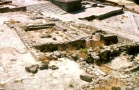 Phaistos Palace at 43.5km (SW) The Upper Court is the first of the three courts in the West Wing of the Palace. Its south side is supported by a strong retaining wall separating it from the West Court. On the west side, the 17 circular recesses in the ground indicate the presence of an equal number of wooden columns which probably supported a covered colonnade. The court is crossed from north to south by a raised "Processional Causeway", which, like those of the other palaces, would have been used for sacred processions and other rituals. The Upper Court also functioned as a kind of balcony from which one could watch the events taking place in the West Court, which is just to the south and on a lower level. The two courts are linked by a majestic staircase starting in the southeast part of the Court. The buildings on the south side of the court were built much later, in Hellenistic times (323-67 BC), when the palaces had already beendestroyed. The most important of these contains a room with two columns, a central hearth and stone benches around the walls. It isbelieved to be a public building, probably a Prytaneion or Andreion.Early Christian tombs (330-600 AD) can be seen east of the "Processional Causeway" Image Library
North Wing Phaistos Palace at 43.5km (SW) The North Wing is one of the most important wings of the Palace, as it is believed to have housed the "Royal Apartments". lt also contained sets of rooms, inner courtyards, corridors and staircases leading to the upper floor. The splendid gateway on the north side of the Central Court led to the complex of the "Royal Apartments". It is framed by two magnificent wooden half-columns, now reconstructed. On either side of the gateway are two niches decorated with wall paintings, in which the gate guards may have stood. Behind the gateway is a wide corridor with a drainage duct, which led to an inner courtyard, which in turn led to the "Royal Apartments" complex. The term "Royal Apartments" was established by the excavators, who followed the terminology applied by Evans to similar areas at Knossos. They are undoubtedly official apartments with particular architectural features, such as open balconies and colonnades, polythyra (pier-and-door partitions), lightwells and "Lustral Basins". The gypsum slab flooring and colourful wall paintings gave these apartments a particularly luxurious appearance. 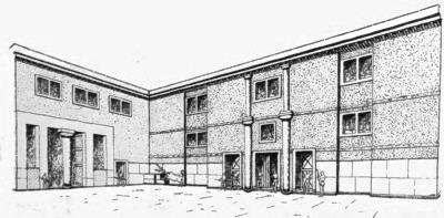 Image Library
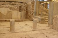
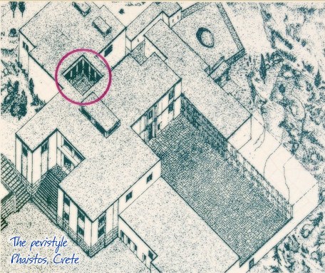
Peristyle Phaistos Palace at 43.5km (SW) The open peristyle court was one of the most elegant inner courtyards of the New Palace. It consisted of an impressive peristyle with four columns on each side supporting the corresponding colonnades, while the central area remained open. The same construction appears to have continued on the upper floor, with a second row of columns. The peristyle court was a focal point of the Palace with access routes leading from here to the "Royal Apartments", the Propylaea and the Central Court. The ruins visible on a lower level in the centre of the peristyle belong to a house of the Prepalatial settlement (3200-1900 BC).
 Phaistos Palace at 43.5km (SW) The northernmost of the "Royal Apartments" has been identified as the King's Megaron and bears a striking resemblance to the corresponding "King's Megaron" at the Palace of Knossos. It consists of a spacious central hall with impressive polythyra (pier - and - door partitions) on the north and east sides. The east polythyron communicates with a second room with two columns, which opens onto a large light-well to the east. The gypsum slab flooring with red plaster filling, the interstices, gave the whole complex a particularly sumptuous air. The north side of both rooms opens onto a spacious colonnade with columns set far apart, offering a magnificent view of Mount Psiloritis and the sacred Kamares Cave. A long corridor at the back of the polythyron room leads to the impressive "Lustra1 Basin" of the Megaron. The whole apartment was decorated with colourful wall paintings depicting linear and plant motifs. Image Library
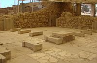
 Phaistos Palace at 43.5km (SW) The southernmost of the "Royal Apartments" ofPhaistos has been identified as the Queen'sMegaron. It consists of a beautiful, spacioushall with a double colonnade opening ontoa light-well. The floors are paved with gypsum slabswith red plaster filling the interstices. Gypsumwas also widely used for the benches runningaround the walls of the Megaron and the facingof the lower part of the walls. The upper walls aredecorated with frescoes depicting plant motifs. Twobeautiful rhyta (libation vessels) were found here: one is decorated with the cult symbols of thedouble axe and sacral knot, while the other bears areed pattern. The two staircases to west and north led to the upper floorof the Megaron and the peristyle, where one of the mainentrances to the "Royal Apartments" was located. Image Library
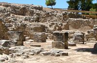 Phaistos Palace at 43.5km (SW) The complex of four rooms on the northeast edge of the Palace does not belong to the Old Palace, although it directly adjoins it. In the westernmost building is an elongated rectangular room with partitions of vertical clay slabs. Similar "cists" in the Palaces of Knossos and Zakros were used to store valuable ritual vessels. Here they were found empty. Next door, in the narrow rectangular room to the southeast, was found a clay tablet inscribed in Linear A and the famous "Phaistos Disc" bearing hieroglyphic writing. The building was therefore named the Palace "Archive" The building east of the Archive is thought to be a shrine or the archivist's residence, while the easternmost building is known as the "Potter's Workshop" because a large number of unfinished pots were found there. The intermediate building has an impressive peristyle of alternating pillars and columns. A staircase on the south side of the peristyle building connects the whole complex to the NE entrance to the Palace, which stood in this spot. Image Library
|

|
||
|
| |||
C
O
N
T
E
N
T
S
O
N
T
E
N
T
S