interkriti®
YOUR GATEWAY TO CRETE
HOME
CRETE FACTS
NAVIGATE
EXPLORE

Agia Galini
Triopetra
Kissamos
Chryssi Isl.
Agia Marina
Balos
Gavdos isl.
Georgioupolis
SAMARIA
IDA Mtn
Palaiochora
Agia Roumeli
Sfakaki
Bali
Kalamaki
Matala
Lassithi
Plateau Lendas
Tsoutsouros
Vianos
Myrtos
Sfakia
Plakias
Ierapetra
Makrygialos
ZAKROS
Vai
Sitia
Agios Nikolaos
Elounda
MALIA
Hersonissos
Gouves
Chania
Rethymnon
Heraklion
GORTYN
FESTOS
KNOSSOS
|
|
Crete
List Grid Map
Found
264
- Showing :
201 - 220
 Beach in South Iraklion at 39.2km (SW) Tripití (or Trypití GR: Τρυπητή) is a 400m long beach on the southern Asterousia coastline. It is located 57km from Heraklion (west gate, Giofyros) via Agioi Deka - Vagionia - Vassiliki - Trypiti road. The last 10km, from Vassiliki to Trypiti, is a dirt but in fairly good condition road. The road passes over the gorge of Agios Savvas, with spectacular rocky walls, then through a forest of olive and carob trees and finally via the gorge of Trypiti through a very narrow passage reaches the beach. This is a very interesting route with breathtaking views and fantastic scenery. Image Library
 Ierapetra, Lassithi at 39.6km (SE) A stately village built in settlements, 22 km away from Ierapetra, at an altitudeof 225 m, next to the Ierapetra-Vianos provincial road. A green landscape,overgrown with olive trees, with an unlimited view of the Libyan Sea, to thesurrounding areas Koleitos, Kakon Oros, to the beaches Vatos and Kallikovrechtis.An almost abandoned village, with old houses built of stone, with chiseled doorframes and coats of arms bearing the Christian cross and proving its old gloryand history.Giannis Dimitromanolakis, an author from Gdohia, writes:“Gdohia sprouted right opposite the beach of the Libyan Sea. Nothing wouldhave been better for the pirates, who, like diabolical ghosts, emerged into thenight to kill and prey. The village’s history is dipped in blood, as it often sufferedfrom the raids of the pirates from the Barbary Coast. It took the name Gdohiafrom the catastrophes, from the verb “gdyno”, to skin, to set fire, to devastate.”Gdohia’s course in time has evidence of struggles, sacrifices and holocausts toshow. It was not only exposed to the pirates but it was situated on the naturalsouth passage going from the Viannos area to the Ierapetra area. This meantthat the hordes of barbarous conquerors burnt and devastated it, along withthe other Symiana villages, as they are called, in the West Ierapetra.Gdohia’s settlements are built leaving a distance between each other: KatoGdohia or Pitropiana, taking their name from the Epitropakis family livingthere, Pefkiana or Grysboliana, from the Grysbolakis family, Dimitromanolianafrom the Dimitromanolakis family, Daskaliana from the Daskalakis family,Papadiana from the Papadakis family. Great stonecutters, stoneworkers,famous for their art, Gdohia’s residents built the mansions of the whole areaand the famous bridge of Myrtos using stones from the quarries of Kolleitos.The miraculous church of Panagia (Our Lady) Evaggelistria of Gdohia, a workof art and a great ecclesiastical monument is also built by Gdohia’s residents.Gdohia village, once the seat of a Community, today a Local Department ofthe Municipality of Ierapetra, presents an exceptional sight-seeing interest. Itprovides natural landscapes, beautiful beaches, picturesque little churches onthe hills, a spacious square with palm trees, seats and a war memorial forthe fallen fighters of the liberation wars. In the 1881 census, 296 residents areregistered and 73 in 2001. Gdohia’s permanent residents, along with someforeigners’ families who have bought and renovated old houses, struggle forthe village’s development which gradually acquires the necessary infrastructures.A village with rich history and civilization, with vast olive groves, a nicemild climate, both during summer and winter, it hopes to come back to life.The old mansions, half-wrecked and burned in the German Occupation, standas if they were sculptures, a painting with the deep blue Libyan Sea serving asa background, narrate the flourishing, the glory and the history of Gdohia andwait to be inhabited again.
 Ierapetra, Lassithi at 39.6km (SE) Deep inside the valley of the river Sarantapihos is built the village Mythoi. It is 22 km away from Ierapetra, it is a small village, in a verdurous landscape,with a beautiful square under the shade of age-old planes. It is said that the village took its name from the plant “Minthi”, or mint, which is abundant there.However, it may have been named thus because of its many legends, traditions, and myths (mythoi), the most prevalent one being the Sarantapihos’ one. A mythical giant, forty ells tall, like another Talos or Akritas Digenis, he protected the residents from raids. There are the place names “Tou Sarantapihoui Patounia” (Sarantapihos’ footprint) and “Tou Sarantapihou to Mnima”(Sarantapihos’ grave). There is evidence of ancient habitation at the site “Leniko” where traces of walls can be seen. Also, in an excavation, the head of a woman of the Roman period has been found. At the sites Kastelou Haraki and Orfanou to Spiliari claypots, oil lamps, e.t.c. have been found. The site called Sarakina above Mythoi was a fortress, a hideout of Saracen pirates. The village’s modern history is rich in contributions to the struggles against the conquerors. It nurtured the chieftains Emmanouil Xenikakis, Ioannis Hatzakis, Emmanouil Christakis andothers. During the German Occupation, residents of Mythoi took part in the guerilla corpses of the United Resistance of Captain Bantouvas. In the battle of Symi, one of the most heroic figures was lost, Apostolos Vagionakis, who stood up to the enemy’s bullets for the ideals of our unsubdued Crete. They paid the price of their participation to the struggles during the German Occupation,as 4 persons were executed, including the old and bedridden Nikolaos Ioannou Christakis. The community of Mythoi is today a Local Department of the Municipality of Ierapetra, in 1900 it had 360 Christian residents, in 1951 it had 423 and in 2001it had 287. In the north of Mythoi, around 6 km away, there is the settlementKarydi with the famous Monastery of Panagia (Our Lady) Karydiani and now abandoned summer residences. The mountainous settlement “Minos”, which is situated in a verdurous small plateau below the Afentis peak of the Lasithi mountains, also belongs to the Community of Mythoi.The village Mythoi is a lively village with a rich social and cultural life. It has a cultural association, a football team and field, and a modern olive press. The village’s square with its old plane trees, the mulberry trees, the old fountain,the traditional coffee-houses with the raki and the local dishes, is a place of reference for the residents of Mythoi. The sights, the wild natural landscapes in the north of the village, the famous gorge of Sarakina, a monument of natural beauty, attract a lot of local and foreign visitors. The gorge of Sarakina is one of the most beautiful in Crete. Its steep, vertical sides cause awe, and reach a height of up to 250 m. Its widest opening is no more than 15 m while in some places it’s so narrow that its sides seem joined. Its rich flora and fauna, dittany,the wild birds that nest there and the route inside the gorge are breath-taking. Its promotion is a foremost goal of the Local Department and the Municipality of Ierapetra, of the residents of the village, who head to the future with optimism and anticipation for the development of their place. Source:The Municipality of Ierapetra.  Moires, Messara at 39.7km (SW) The monastery of Panagia Kaliviani is located at the 59th km on the road Iraklion-Phaistos. The monastery was built during the second Byzantine period. The small Byzantine chapel was painted with frescoes but most of them are today destroyed. The chapel was deserted until, during the Turkish occupation in 1873, an old small icon of the Annunciation of the Holy Mother was miraculously found there.and the monastery became a place of worship.  Ierapetra, Lassithi at 39.8km (SE) Mournies (GR: Μουρνιές - meaning: mulberry trees) is a village of the western Ierapetra. It is located north of Myrtos, and 25 kilometers away from Ierapetra at 275m (elevation), built on the southeastern outskirts of the Lasithi mountains, with beautiful views of the Libyan Sea and the plains of Ierapetra. It has a mild climate, without extremes, ideal both for permanent residence and for holidays. The landscape is hilly plenty of olive trees. In the 2001 census it had 83 residents. Mournies is a beautiful, historic, picturesque and traditional village with cafes, a square with a war memorial, an old fountain, and narrow streets branching off the main street of the village. Mournies was named after the Mulberry tree which however is not abundant in the area.  by Richard Ellis at 39.8km (W) This is my log of the E4 long distance walk along the spine of Crete from East to West - it is intended to be a useful resource for others who are contemplating a similar walk along the E4 in Crete; it is not intended in any way to be a complete route guide.
 Voroi, Messara, Iraklion at 40.4km (SW) The exhibited objects in the Museum come from all over Crete. These objects show that the folk culture of Crete is characterized by an amalgam of influences in which Minoan (2000-1000 BC), Archaic (1000-500 BC) and Byzantine models prevail, especially in agriculture, stock breeding, pottery and basketry.
 Messara, Iraklion South at 40.6km (SW) Vori is a beautiful, traditional village of the county of Pirgiotissas in the Messara Valley. It is located 60 km south of Iraklion and in the western part of the Messara Valley. The village stretches in a slope, by the side of a small river. The archaeological site of Phaistos is 2 km to the south and the coast of Messara 4 km to the west.
 Mirabello, Lasstithi at 40.6km (E) Kritsa is one of the most picturesque towns in Crete, built amphitheatrically on a rock hill. It is located 11 km from Agios Nikolaos and has 2000 inhabitants. The people keep the old Cretan customs and the traditions and the town is considered one of the most important centers of the Cretan folk and weaving art.
 Mirabello, Lasstithi at 40.9km (E) Lato (Gr: Λατώ) was an ancient city of Crete, the ruins of which are located approximately 3 km from the small town of Kritsa. The Dorian city-state was built in a defensible position overlooking Mirabello Bay between two peaks, both of which became acropolises to the city. Although the city probably predates the arrival of the Dorians, the ruins date mainly from the Dorian period (fifth and fourth centuries BC). The city was destroyed ca. 200 BCE, but its port (Lato Etera or Lato pros Kamara), located near Agios Nikolaos was in use during Roman rule. There is some suggestion that the city was named after the goddess Leto (of which Lato is the usual Doric form) and may be mentioned in Linear B tablets as RA-TO. Lato also minted coins in antiquity,[3] bearing the likeness of the goddess Eileithyia who appears to have been the one particularly worshipped at Lato. Nearchus, admiral of Alexander the Great, was born at Lato.  South Iraklion at 41.1km (SW) Tráfoulas is a secluded beach, nested in a cove open to the south, at the small promontory of the same name, located between Lendas and Trypiti. You can reach Trafoulas only by boat or on foot via a small canyon. The starting point is around 700m away, to the north, just above the small harbour of Loutras, around 5km east from Lendas, where there is a place for parking. You then follow the hiking path, descending for a while to meet the canyon that leads directly to the beach. The walk takes around 20 minutes and its very nice as there are plenty of oleander and the rocky walls are very spectacular continuing until the sea. Image Library
North Wing Phaistos Palace at 41.2km (SW) The North Wing is one of the most important wings of the Palace, as it is believed to have housed the "Royal Apartments". lt also contained sets of rooms, inner courtyards, corridors and staircases leading to the upper floor. The splendid gateway on the north side of the Central Court led to the complex of the "Royal Apartments". It is framed by two magnificent wooden half-columns, now reconstructed. On either side of the gateway are two niches decorated with wall paintings, in which the gate guards may have stood. Behind the gateway is a wide corridor with a drainage duct, which led to an inner courtyard, which in turn led to the "Royal Apartments" complex. The term "Royal Apartments" was established by the excavators, who followed the terminology applied by Evans to similar areas at Knossos. They are undoubtedly official apartments with particular architectural features, such as open balconies and colonnades, polythyra (pier-and-door partitions), lightwells and "Lustral Basins". The gypsum slab flooring and colourful wall paintings gave these apartments a particularly luxurious appearance. 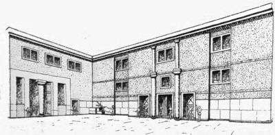 Image Library
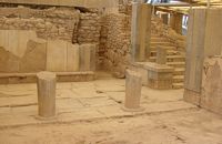
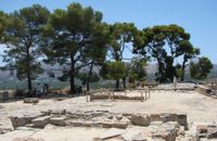
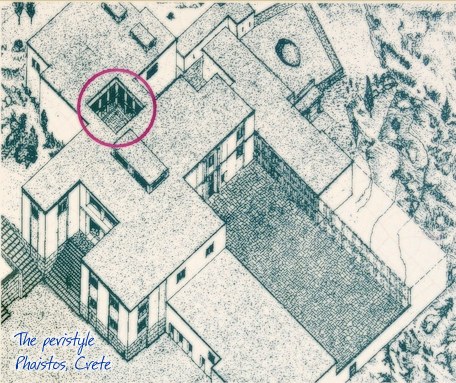
Peristyle Phaistos Palace at 41.2km (SW) The open peristyle court was one of the most elegant inner courtyards of the New Palace. It consisted of an impressive peristyle with four columns on each side supporting the corresponding colonnades, while the central area remained open. The same construction appears to have continued on the upper floor, with a second row of columns. The peristyle court was a focal point of the Palace with access routes leading from here to the "Royal Apartments", the Propylaea and the Central Court. The ruins visible on a lower level in the centre of the peristyle belong to a house of the Prepalatial settlement (3200-1900 BC).
 Phaistos Palace at 41.2km (SW) The northernmost of the "Royal Apartments" has been identified as the King's Megaron and bears a striking resemblance to the corresponding "King's Megaron" at the Palace of Knossos. It consists of a spacious central hall with impressive polythyra (pier - and - door partitions) on the north and east sides. The east polythyron communicates with a second room with two columns, which opens onto a large light-well to the east. The gypsum slab flooring with red plaster filling, the interstices, gave the whole complex a particularly sumptuous air. The north side of both rooms opens onto a spacious colonnade with columns set far apart, offering a magnificent view of Mount Psiloritis and the sacred Kamares Cave. A long corridor at the back of the polythyron room leads to the impressive "Lustra1 Basin" of the Megaron. The whole apartment was decorated with colourful wall paintings depicting linear and plant motifs. Image Library
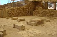
 Phaistos Palace at 41.2km (SW) The southernmost of the "Royal Apartments" ofPhaistos has been identified as the Queen'sMegaron. It consists of a beautiful, spacioushall with a double colonnade opening ontoa light-well. The floors are paved with gypsum slabswith red plaster filling the interstices. Gypsumwas also widely used for the benches runningaround the walls of the Megaron and the facingof the lower part of the walls. The upper walls aredecorated with frescoes depicting plant motifs. Twobeautiful rhyta (libation vessels) were found here: one is decorated with the cult symbols of thedouble axe and sacral knot, while the other bears areed pattern. The two staircases to west and north led to the upper floorof the Megaron and the peristyle, where one of the mainentrances to the "Royal Apartments" was located. Image Library
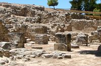 Phaistos Palace at 41.2km (SW) The complex of four rooms on the northeast edge of the Palace does not belong to the Old Palace, although it directly adjoins it. In the westernmost building is an elongated rectangular room with partitions of vertical clay slabs. Similar "cists" in the Palaces of Knossos and Zakros were used to store valuable ritual vessels. Here they were found empty. Next door, in the narrow rectangular room to the southeast, was found a clay tablet inscribed in Linear A and the famous "Phaistos Disc" bearing hieroglyphic writing. The building was therefore named the Palace "Archive" The building east of the Archive is thought to be a shrine or the archivist's residence, while the easternmost building is known as the "Potter's Workshop" because a large number of unfinished pots were found there. The intermediate building has an impressive peristyle of alternating pillars and columns. A staircase on the south side of the peristyle building connects the whole complex to the NE entrance to the Palace, which stood in this spot. Image Library
 Phaistos Palace at 41.2km (SW) The east part of the North Wing forms the workshop area of the Palace. It consists of the East Court and a complex of small rooms which are believed to be the workshops of the New Palace (1700-1450 BC). Approximately in the centre of the court are the ruins of a horseshoe-shaped kiln. The elongated rectangular building with 6 rooms on the west side of the court appears to have been used for the workshops of the kiln craftsmen. The square room on the north side of the court was the gatehouse of the northeast entrance to the Palace. It has gypsum slab flooring and benches around the walls. Behind it is a long corridor leading to the inner courtyard of the North Wing and thence to the "Royal Apartments" Image Library
 Palace and Archaeological Site at 41.3km (SW) The archaeological site, the palace, the findings - The Festos Disc. According to mythology, Phaistos (or Festos) was the seat of king Radamanthis, brother of king Minos. It was also the city that gave birth to the great wise man and soothsayer Epimenidis, one of the seven wise men of the ancient world.Excavations by archaeologists have unearthed ruins of the Neolithic times (3.000 B.C.).
Image Library
 Mirabello, Lasstithi at 41.3km (E) The Panagia Kera of Kritsa, as it is called the Temple of the Virgin Mary (Kera), is 1 km to the north of the village of Kritsa in Merabello Lassithi, in a place called Logari, right on the road from Agios Nikolaos to Kritsa. The history of the church of Panayia Kera begins at least since the 13th century. 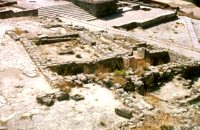 Phaistos Palace at 41.3km (SW) The Upper Court is the first of the three courts in the West Wing of the Palace. Its south side is supported by a strong retaining wall separating it from the West Court. On the west side, the 17 circular recesses in the ground indicate the presence of an equal number of wooden columns which probably supported a covered colonnade. The court is crossed from north to south by a raised "Processional Causeway", which, like those of the other palaces, would have been used for sacred processions and other rituals. The Upper Court also functioned as a kind of balcony from which one could watch the events taking place in the West Court, which is just to the south and on a lower level. The two courts are linked by a majestic staircase starting in the southeast part of the Court. The buildings on the south side of the court were built much later, in Hellenistic times (323-67 BC), when the palaces had already beendestroyed. The most important of these contains a room with two columns, a central hearth and stone benches around the walls. It isbelieved to be a public building, probably a Prytaneion or Andreion.Early Christian tombs (330-600 AD) can be seen east of the "Processional Causeway" Image Library
|
|||
|
| |||


C
O
N
T
E
N
T
S
O
N
T
E
N
T
S