interkriti®
YOUR GATEWAY TO CRETE
HOME
CRETE FACTS
NAVIGATE
EXPLORE

Agia Galini
Triopetra
Kissamos
Chryssi Isl.
Agia Marina
Balos
Gavdos isl.
Georgioupolis
SAMARIA
IDA Mtn
Palaiochora
Agia Roumeli
Sfakaki
Bali
Kalamaki
Matala
Lassithi
Plateau Lendas
Tsoutsouros
Vianos
Myrtos
Sfakia
Plakias
Ierapetra
Makrygialos
ZAKROS
Vai
Sitia
Agios Nikolaos
Elounda
MALIA
Hersonissos
Gouves
Chania
Rethymnon
Heraklion
GORTYN
FESTOS
KNOSSOS
|
|
Crete
List Grid Map
Found
225
- Showing :
201 - 220
 Gortyn archaeological site at 42.9km (SW) The main acropolis of Gortyna was located on Agios Ioannis hill, to the northwest of the Agora. Acropolis can be accessed from its west side driving through Ambelouzos village to the direction of Gergeri. At a spot around 1.6 kms from Gortyna parking there is a footpath (not clearly signposted and maintained) that leads to the top of the hill. Once at the top you'll be rewarded by the magnificent view to the whole area and the archaeological site itself. The site was first inhabited in the Neolithic era and again at the end of Minoan times (1200 BC). Since then it was continuously inhabited until the Middle Byzantine period. From the first settlement only parts of walls, floors and hearths were preserved. In the 10th century BC a Geometric settlement was established fortified by a polygonal wall with towers at the corners. At the end of the 7th c. A.D., a small tripartite temple, dedicated to Athena Poliouchos was founded at the south side of the hill. From this temple some very important architectural sculptures were excavated. During the Early Byzantine period (5 - 6th century AD), a basilica was erected over the ruins of the geometric/archaic temple and, in the time of the emperor Heraclios (7th century A.D.) the last fortification with a castle in the center was built which still survives but in a very poor condition. Image Library
 Gortyn at 42.9km (SW) The Temple of Apollo Pythios (Pythian Apollo) located in the center of the ancient Agora, was excavated in 1887 and was the largest temple and the religious center of ancient Gortyn until the introduction of Christianity and the founding of the basilica of St. Titus around 500 AD. The first building of the seventh century. BC was a four-sided enclosure with four wooden pillars in the center to support the roof. The exterior walls and stairs of the crepis were covered with archaic inscriptions. In the Hellenistic period a monumental anteroom was added while columns with inscriptions were placed between the pillars. Alterations and additions were made during the Roman period. Outside the temple was built a magnificent altar on a stepped base while in the west of the temple was built a small theatre. In the middle Byzantine period in the vicinity of the temple, which had been abandoned, were built houses and aqueducts. Many finds have been made in the temple among which the colossal statue of Apollo Pythios and many inscriptions with administrative and law content of the Archaic and Hellenistic period. Dates: 7th c BC; Hellenistic; 2nd c AD. Image Library
 Gortyn archaeological site at 42.9km (SW) It lies at the south eastern part of the city and it is considered to be largest of all theaters in Gortyna. Although it is not yet excavated, it is believed that it had a two storeyed stage and its cavea was supported by 56 arches. The statue of the seated philosopher that we see next to the exhibition hall of the archaeological site was found here.
Image Library
 Gortyn archaeological site at 43km (SW) Saint Titus church at Gortyn bears the name of the Apostle Titus, attendant of Apostle Paul, who was appointed as the first Christian bishop of Crete. It is one of the most important Byzantine monuments in Crete. The name was given to the ruined church by the excavators in the beginning of the 20th c., as they considered it to be the site of the saint’s martyrdom. After the discovery of the new Great Early Byzantine Basilica, just outside the village Mitropolis, its excavators have proposed that as the original bishopric basilica, as it is a century earlier than this, which in the local tradition is named and celebrated after Virgin Mary, “Kera”. The church has the plan of a three aisled inscribed cross with a low vault. It has been built of ashlar limestone. It has a narthex to the west and five entrances three of which form the trivelum with two columns. There were pillars instead of columns. Its architectural features date its foundation in the 2nd half of the 6th c. AD. Image Library
 Gortyn archaeological site at 43km (SW) The oldest theater of Gortyna was on the south slope of the Profitis Ilias hill (Acropolis), opposite to the Odeum. Its cavea was partly cut into the rock and partly built. Its scene was built at the west side of the large court of the Agora, which covered the river Lethaios with a flat bridge. This scene, which H. Belli saw in the 16th c AD, was 120 m long and was already destroyed in 19th c. AD. On the proscenium there was an inscription of Julia Augusta and it was decorated with statues and relies, among which there was the statue of Europe on the Bull, with broken legs and head.This statue, as described by Admiral Spratt, is now kept in the British Museum and is dated to the 2nd c BC.  Gortyn archaeological site at 43.2km (SW) This unique monument has been excavated in the last thirty years. It is located on the road between the Saint Titos Church and the village Mitropolis. It is the largest early Byzantine basilica in Crete and among the largest in whole Greece. In early Byzantine period it was the cathedral of the city. The first five-aisled basilica was erected here in the early 6th c., in the years of the Emperor Justinian and stood for about 70 years. The central aisle had a mosaic pavement decorated in geometric patterns and animals. It is believed that there were mosaics of stone and glass tesserae on the walls, too. The other aisle had pavements of limestone slabs. The columns were made of white and gray white marble. Of great importance is the pulpit, which resembles that of Saint Sophia in Constantinople. It was a high exedra on low columns and two stairs for ascent and decent. The choirs stood under the exedra. After the destruction of the first basilica in 620 AD, a new basilica was built over its ruins in the time of the Emperor Heraclios. This basilica, following the fortune of the whole city, was destroyed after the strong earthquake of 670 AD.
Image Library
 Gortyn archaeological site at 43.2km (SW) The Hippodrome was located in the south part of the city of Gortyn, and was surrounded by columns. The central section was 374 metres long and 60 metres wide. Our information on the site is insufficient for the reason that there was never a systematic survey, or even a small excavation. What we see today of this magnificent monument are only some parts of columns and capitals.
Image Library
 Anogia at 43.5km (W) The artistic events, which take place every year in the first week of July at the same place called Fourni and in the Cretan village of Anogia. The poet, songwriter and singer from Anogia, who they call "Loudovikos from Anogia" wants to make the history of the young martyr, who supersedes his fear in love known to the public. And because 1.900 years have passed since the martyrdom of Yakinthos, he decided to honor the Saint of Love and sing together with him of the poetry of love.(www.yakinthia.com)
 Village in Messara plain at 43.7km (SW) Mitropoli (GR: Μητρόπολη) is a small village in the archaeological site of Gortyna in Messara plain. The village is mentioned for the first time in the Ducal archives of Candia in 1368 and later in the census of 1577 by Fr. Barozzi and in 1583 by Castrofylaka. Early mention of the settlement is to document the Ducal Archive of Candia in 1368, also mentioned by Fr. Barozzi in 1577 with the name and the Mitropoli Kastrofilakas in 1583. According to the census of 2001 it has 382 inhabitants. Main occupations of the inhabitants is the cultivation of vines, olives, vegetables, cereals and citrus fruits. At its north borders are located the ruins of the first cathedral of St. Titus, in which it owes its name.(Mitropoli = Cathedral). Image Library
 Zaros at 44.2km (W) This is one of Crete's most famous monasteries. It played an important role during the years of the Cretan Renaissance, both in the letters and the arts, and, during the last centuries of Venetian rule, it was known for its many scholars, artists and venerable monks.
 Pahia Ammos, Ierapetra at 45.1km (SE) Gournia lies on a small hill, a few hundred metres from the sea in the Gulf of Mirabello, close to the north end of the Ierapetra isthmus ( 2 Km from Pachia Ammos village & 19 Km from Ag.Nikolaos). Gournia - the ancient name of which is not known - is the most characteristic of the excavated medium-size settlements, dated to the period of the peak of the Minoan culture (Late Minoan I period: 1550-1450 B.C.). It is called "Pompeii of Minoan Crete" because of the good state of preservation. It occupies a low hill, close to the sea, at the Isthmus of Ierapetra. 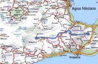 by Richard Ellis at 45.1km (SE) 5th June.- The GPS certainly gave me confidence whenever I came to junctions and occasionally the fairies who put up the E4 signs reassured me as well. If ever there was a “walk of the gods” it is here, as it contours round under Chalasmeni Korfi at over 1,000 metres and becomes steadily greener and more wooded. Distance:38.5 km Time: 11.5 hrs. Mov av 4.7 km/hr Height overnight: 887m.(max 1,100m.)  Voriza, South - West Iraklion at 45.8km (W) Close historical bonds link this monastery to that of Vrontisiou. The Varsamonerou Monastery lies in the surrounding fields of the village Voriza, 54.5 kms from Heraklion. The monastery is abandoned and, though its cells have been destroyed, its church has some of the most remarkable wall paintings in Crete.
 Psiloritis Mountain at 45.9km (W) The plateau is located in the center of the Ida mountain range at an altitude of 1400 m. It can be accessed from various sides but the only asphalt road is from the town of Anogeia. It has a roughly triangular shape and is almost flat. Visitors can enjoy the wild landscape, take a walk to the entrance of Idaion cave or to the freedom fighter sculpture, made with boulders from the mountain. An other interesting attraction is the various Mitata scattered all over the area. Those are circular domed buildings made with stones and used by shepherds for accommodation and storage of cheese. There is also a tavern with traditional food. The area of Nida, in earlier times, before the systematic farming and logging damage the flora of Psiloritis, was covered by forests in which mythological and traditional tales put different events. Here Dimitra fell in love with the mortal Iasion. http://www.anogialand.gr  Pachia Ammos at 45.9km (SE) The Institute for Aegean Prehistory Study Center for East Crete (or INSTAP-SCEC) is a unique facility for archaeological research, especially in the area of Aegean Prehistory. The Center is committed to stimulating and facilitating publication in the broader field of Cretan studies, with a focus on archaeology and ethnology.
 Ierapetra, Lassithi at 47km (SE) Ierápetra (GR: Ιεράπετρα), the southernmost town of Crete, combines a brilliant past with a present of economic growth and extension. The temperature seldom falls below 12°C, and the mean annual temperature is 20°C, also it is the sunniest and hottest region of Greece. It has a long sandy beach and clean blue sea, a picturesque port with the castle "Kales", an archaeological Museum, and many more attractions. Visitors will find a wide range of accommodation facilities and lots of interesting things to do and see in the town and the wider area as well.
Image Library
 Psiloritis Mountain at 47km (W) At 1538m above sea level, 20 km. south of the traditional town of Anogia , on the plateau of Nida, of Mountain Psiloritis, lies this sacred cave, where according to mythology, Rhea, Zeus' mother, hid the new born Zeus in this cave in order to protect him from his father Kronos (Saturn), who was in the habit of swallowing his children because he feared they might deprive him of his power. Hidden in that cave Zeus grew up being fed with the milk of the goat Amalthia, while the 'Kourites" covered the child's crying through banging their copper shields. Image Library
 Ierapetra town, South Lassithi at 47km (SE) The museum was founded at the end of the 19th century, during the Turkish occupation of Crete and was housed in several buildings in the past. Today it is housed in the building of the Commercial Ottoman School, which is protected by a preservation order. The collection includes findings from the broader area and from the Minoan to the Roman period. Among the items are painted sarcophagi, lamps, vases, figurines, relief plaques. One of the most important exhibits of the museum is the Clay sarcophagus dated to 1450-1400 B.C.
Image Library
 by Richard Ellis at 47km (W) 15th June- The path up to the summit of Psiloritis is well-known and well-marked and does not need any further description from me. Fortunately for me, my pack was lighter by about 4 kg as I had handed over my camping equipment and extra food supplies to T who was going to catch the ferry back from Chania two days later and who could drop my gear at the flat en route. Distance:20.1 km Time: 8 hrs. Mov av 3.2 km/hr Height overnight: 427m. Max. height:2,454 m  Mires, Messara Valley at 47.1km (SW) It is located north of Mires close to a small gorge, with springs and covered with trees. There are many churches in the village the most important one being the church of Agios Nikolaos, a domed church dated to the 13th century. The walls of the temple are hand painted with biblical scenes and pictures of saints
|
||
|
| ||


C
O
N
T
E
N
T
S
O
N
T
E
N
T
S