interkriti®
YOUR GATEWAY TO CRETE
HOME
CRETE FACTS
NAVIGATE
EXPLORE

Agia Galini
Triopetra
Kissamos
Chryssi Isl.
Agia Marina
Balos
Gavdos isl.
Georgioupolis
SAMARIA
IDA Mtn
Palaiochora
Agia Roumeli
Sfakaki
Bali
Kalamaki
Matala
Lassithi
Plateau Lendas
Tsoutsouros
Vianos
Myrtos
Sfakia
Plakias
Ierapetra
Makrygialos
ZAKROS
Vai
Sitia
Agios Nikolaos
Elounda
MALIA
Hersonissos
Gouves
Chania
Rethymnon
Heraklion
GORTYN
FESTOS
KNOSSOS
|
|
Crete
List Grid Map
Found
265
- Showing :
221 - 240
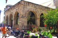
 Gouves, Iraklion at 40.7km (E) At a height of 320 m above sea-level, Kalo Chorio (GR: Καλό Χωριό) λιεσ 25.7 kms. from Heraklion, to the right at the cross-roads at km 16.7 on the National Road to Agios Nikolaos and on the road to Gouves- Koxare- Kalo Chorio. The present name does not figure in old Venetian documents, though there is a reference in the 1367 Duke’s archives of Chandax to a Kalo Horio, without however naming the district. The villagers maintain that the village was called Stravorina in the old days, and indeed there is a reference by Barozzi in 1577 to a village Stravorina in the district of Pediados. In the 1583 Register, the village Stravorina is mentioned as having 76 inhabitants and in the Turkish census of 1671 Istavrine is quoted as having 21 "charatsa" (A Turkish word referring to a tax paid by the head of each family; hence 21 families). However, Chourmouzis Vizantios in 1842 mentions Kalo Chorio, the present name was therefore given in the decade 1830-1840. The village counted 298 inhabitants in 1981 which is also the current population. The Maza hill-top, south-east of the village, is 457 metres high. According to archaeologists (among them the famous N. Platon) and on the basis of recent finds, the name Maza comes from pre-Hellenic years and means Mother Earth. The pile of stones on the hill was, according to N.Platon, a town from the 10th to the 8th c. BC. The highest part was undoubtedly used as a shrine in Middle-Minoan years, and clay figurines and offerings were found there. The shrine lay quite close to the town. The shrine stopped being used in Proto-Geometric years. Northeast of the village, by the country road that leads from Kasteli to Hersonissos, traces of ancient installations have also been found along with remnants of water tanks by a source that is still in use today. These water tanks, probably belonged to Hersonissos aqueduct, parts of which are still visible today in Aposelemi valley. There is as well an interesting gorge close to Kalo Chorio, in the valley of Aposselemis river, worth seeing for nature lovers.  Pediada, Iraklion at 40.9km (E) Bizariano (GR: Μπιτζαριανό) is a traditional small village of about 24 inhabitants in the area of Kasteli Pediada, 320 m above sea level and about 3 km to the north of Kasteli on the road to Hersonissos. A pretty village with stone houses, graphic lanes and courtyards covered in flowers. It is first mentioned in 1881, as Bizariano, Municipality of Kasteli, with 55 Christian inhabitants. In 1951, it changes its name to Pigi. Its first name is that of a family, Bizariano. Close to the village, in a beautiful spot full of lush vegetation, evergreen plane trees and gushing water, stands the ancient church of Agios Pandeleimonas, with its three naves. Two rows of arches supported by columns without capitals separate the naves. Another column is made exclusively of capitals, apparently brought in from other churches or temples. Practically all the middle outside wall is decorated with inscriptions, Byzantine reliefs and crosses. Agios Panteleimon (External) Agios Panteleimon (External) Agios Panteleimon (interior) The artistic highlight of the church of Saint Panteleimon are its fresco scenes painted on the walls which are among the oldest in Crete, although very few frescoes remain. In the lower section of the arch, there is the representation of the three Hierarchs, shown on full length, with vertical inscriptions on it. On the two side walls there are the representations of Saints in a colossal size. These scenes were designed to be a source of biblical education to the faithful, who would have been illiterate at that time. Image Library
 Armenoi, Rethymnon at 41.2km (W) The site was first discovered by a teacher who noticed that two pupils were playing football using a minoan vase as a ball!. He mentioned the fact to the authorities and the excavations that followed unearthed about 300 tombs of the Late Minoan III period (1450-1100 BC). As the tombs had not been yet looted, the archaeologists found significant treasures like vases, weapons, statuettes, jewels etc. It is obvious that such a big cemetery should belong to a big city which, despite the extended investigations of the archaeologists, has not been discovered yet. Image Library
 Pediada, Iraklion at 41.4km (E) Armacha (GR: Αρμάχα) lies at 490 m above sea level, at a distance of 7km from Kastelli, with 110 residents (census 2001) and is first referred to by Barozzi in 1577. Armacha is rich in the production of agricultural and livestock products. The Metropolitan Bishop, Tirnovos Voulgaria Ilarionas Kabanaris Sinitis was born, and is also buried here. A man of advanced learning, he wanted to translate the Bible to Demotic Greek.  Pediada, Iraklion at 41.6km (E) Anbother beautiful small settlement, with 38 people, Kato Karouziana (GR: Κάτω Καρουζανά) lies at an altitude of 300m and is located at 49km from Herakleion and 1km from Epano Karouzana. It offers a spectacular view to the Kastelli plain, picturesque paved lanes, traditional kafeneia and taverns and is a popular with tourists, especially in the summer when many Cretan evenings are organized with local music and dance. 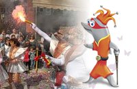 Rethymnon city at 41.6km (NW) In winter the town of Rethymno lives in the rhythm of Carnival. Here, the grandest carnival on the island of Crete is organised. Apart from the great parade on Shrove Sunday, a large number of activities complete the framework of the Carnival festivities. The locals devotedly and cheerfully prepare for this season with creativity, they sacrifice their spare time and become young again while rejoicing and celebrating parties almost on a daily basis. More than 4,000 people have worked feverishly for months in order to present their masks and carriages on the great Carnival parade…The following day, on Shrove Monday people from the countryside play a leading part in the festivities. Unique traditions are revived in the villages and everybody is invited to participate in games, street performances and satires as for example “the kidnapping of the bride”, the “Cadi”, the “smudging of people”. These performances in combination with good wine and the music of the lyre are a successful formula for a unique experience. Links: www.carnivalrethymno.com  Rethymnon Old Town at 41.7km (NW) The Mosque took its name from the Turkish commander of the marine operations to conquer Rethymno, in 1646. During the Venetian Period, the Mosque became a monastery dedicated to St. Barbara. West from the central building, there is the deserted minaret of the mosque. The fountain of the Mosque is attached to the roofed entrance of the Mosque's garden, where believers washed before entering the Mosque and provided the area with fresh spring water. Image Library
 Pediada, Iraklion at 41.8km (E) Geraki (GR: Γεράκι). This lovely village of 375 inhabitants is located on the western slopes of the Lassithi mountains between the peaks of Afendi (1578 m) and Sarakinos (1588 m) in a beautiful glen, 520m above sea level and only 9km SE of Kastelli. It features an interesting Byzantine church, dedicated to the Archangel Michael (Archangelos Michail) with wall paintings that have not been maintained and some interesting (movable) icons by the local painter, Sepis. The active cultural centre of Geraki organizes many events during the summer season. Twice a year the village has a typical Cretan feast in honour of its patron saints: Agia Paraskevi on July 26th and Michail Archangelos on 8th November. The village produces agricultural products and great cheese that led to a specific cheese celebration. From Geraki you can also reach the lovely chapel of Agia Anna, driving through a particularly beautiful landscape with a spectacular view over the Geraki glen and fresh running water, a place ideal for a picnic. Image Library
 Pediada, Iraklion at 41.8km (E) Built at 510 m with 319 people Ksidás (GR: Ξυδάς) also known as Lyttos, is located at 3 km from Kastelli in the foothills of the site of the ancient town Lyttos. The first mention of the village goes back to 1368AD, with the name Ksidas. A burial site was discovered when the road was being constructed, at Chomatolakkos, belonging to late Roman period. Two gold rings have also been found here, the one with stone, showing the portrait of an emperor holding a spear, and the other with a hoop, showing two interlocking hands. A bronze ring with a Greek inscription, along with golden plates and bronze coins, were also found at this site. Image Library
 North West Crete at 42km (NW) Rethymnon (GR: Ρέθυμνον) is the capital of the Prefecture of the same name and it is built between the two other large cities of Crete. The town still maintains its old aristocratic appearance, with its buildings dating from the 16th century, arched doorways, fountains etc. The Fortezza castle, at the top of a low hill named "Palaiokastro" dominates the town. It was built in 1590 to protect the city from the pirates raids and the Turks.
 Rethymnon town at 42.1km (NW) Rethymnon old port was of great strategic importance during the Venetian period. It was only able to accommodate small ships. From 1300 until today, the Venetian port has undergone numerous constructions. The 1618 wall that surrounds the port from the east is restored today with some recent interventions and additions. The original lighthouse was constructed during the Turkish period and was later replaced by another one. The building on the southeast part of the port was constructed in 1931 and functioned as a customs office. On the same location it is estimated that there was a quarantine house during the Venetian period. The vaulted spaces on the two or three-floor buildings at the port have been transformed to little and picturesque fish taverns, where visitors can enjoy the secrets of the Cretan cuisine.
 Rethymnon Old Town at 42.1km (NW) Loggia has been built during the 16th century and was designed by the famous architect Michel Sanmicheli. Loggia was an eminent building of the city centre and has been a meeting point for the nobles to discuss political and economical issues. The building is very well preserved; it is square and has arches on its three sides (besides its west side). The consoles of its eaves are spectacular. During the Turkish occupation the loggia became a mosque and a minaret was constructed, which was later demolished in 1930. The past 40 decades the building of Loggia hosted the archaeological museum of the city, which has now moved to a building next to Fortezza. Today loggia hosts a market of archaeological art copies.
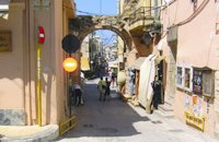 Rethymnon Old Town at 42.1km (NW) The Guora Gate (Porta Guora or Grand Gate)) is the main entrance of the Venetian city walls that protected the city of Rethymno. The gate was built in the years of Rector Rettore Jocopo Guoro (1566-1568). Part of the gate is preserved at the beginning of the street "Ethnikis Antistaseos". It is 2,60 m. wide, built with carved stones with skew acnes, creating a semicircular arc on the top. According to traveler J. Gerola, the initial shape of the gate was formed by stepped cornice and pediment where a relief the lion of St. Marcos (the Venetian emblem) existed. Today the relief is preserved in two pieces and is stored at Loggia's courtyard. Old drawings of Guora Gate: inside the walls - outside the walls Image Library
 Rethymnon Old Town at 42.2km (NW) It is housed in the church of Agios Frangiskos in the center of the old town. It exhibits objects from the Neolithic to the Roman period, found at the prefecture of Rethymno (mainly Eleftherna, Monastiraki and Armeni). Clay figurines, funerary coffers, grave offerings, statues, grave steles, red-figure vases, bronze vessels, jewellery and glass vases, are some of the objects on display. St. Francis Church - 4 Agiou Fragiskou str., Telephone: +30 28310 27506 Email: efareth@culture.gr Open Winter: 08:00 - 15:00 November 1 - March 31 Summer: 10:00 - 18:00 April 1 - October 31, except Tuesday. 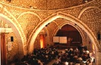 Rethymnon old town at 42.2km (NW) During Venetian occupation the mosque Neratzes, which today is used as a conservatory, was the Augustinian church of the Holy Virgin. In 1657 the Turks transformed it into the mosque 'Gazi Housein' or 'Neratze', and in 1890 they added a large minaret with two galleries, which was built from the famous stones from the village of Alfa. The chapel of the Holy Virgin, situated at its west side and dedicated to the Body of Christ, was also transformed into a seminary. Outstanding elements of this building are the doorframe and the three domes.
Image Library
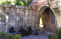 Rethymnon Old Town at 42.2km (NW) A. Rimondi, the Rector of the city, built the famous Rimondi Fountain, which is situated at present day Platanos Square, formerly the centre of Venetian city life, in 1626. The water runs from three spouts in the shape of a lion's head into three sinks. Three small, fluted columns, ornamented with Corinthian capitals are "standing" on the sinks. Above the capitals an entablature can be observed, the middle part of which displays four projections in the shape of the leaves of the acanthus exactly above the columns. Furthermore in this section the words LIBERALITATIS and FONTES are inscribed.
Image Library
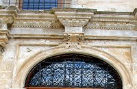 Rethymnon Old Town at 42.2km (NW) The church of Saint Francis is one of the most important monuments of Rethymno. It was the main temple of the Monastery of the Franciscan Order. The architecture of the building - a single aisle Basilica type with wooden roof - and its ornaments are very interesting. Next to the east side of the temple two deserted chapels are preserved. Its Corinthian style main doorway is impressive, with capitals of composite order. During recent excavations around the church valuable archeological findings have been discovered, including two tombs of Venetian nobles. During the Turkish occupation the temple was turned into an "Imaret" (a shelter for the poor). It was also used as a cultural center until 1996. It was recently renovated to accommodate the Byzantine and Post-Byzantine Collection of the Prefecture of Rethymno. 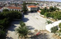 Rethymnon Old Town at 42.2km (NW) The square of Mikrasiaton (GR: Πλατεία Μικρασιατών) formerly the 1st primary school square, in Rethymnon town, covers an area of 7,500 square meters, right at the heart of the city's historical center. It is surrounded by valuable monuments and beautiful buildings, mainly used as cultural centers. There, visitors have the opportunity to rest in a peaceful environment and at the same time visit the various monuments and cultural centers located in the area. Image Library
 Rethymnon Old Town at 42.3km (NW) The Contemporary Art Museum of Crete was founded in 1992 as Municipal Gallery ‘L. Kanakakis'. It is housed in a Venetian building at the old city of Rethymno, below the Fortezza fortress and the Archaeological Museum. It houses a permanent exhibition of the work of Lefteris Kanakakis (oil paintings, sketches and aquarelles), thus representing all the stages of his achievements, as well as works of contemporary Greek artists, which cover a broad spectrum of modern Greek art as it has been accomplished from 1950 until today. Address: 5, Heimaras Str. 741 00 Rethymno Tel: +30 28310 52530 Website :www.rca.gr  Rethymnon old town at 42.3km (NW) The Historical and Folklore Museum of Rethymno is located next to the Neratze Mosque. It is an institution of public benefit, founded in 1973 by the President of the Historical and Folklore Institution, Christoforos Stavroulakis, and Fali Vogiatzaki. The museum is housed in a restored Venetian building with an interior courtyard. The building is a wonderful piece of urban residence of the last phase of the Venetian occupation of Crete, built in the renaissance style by traditional craftsmen. Image Library
|
||
|
| ||


';top.fotoWin('/dbsf/pages_pics/15/1522205/aposselemi_gorge01.jpg','');)
)
)
)
C
O
N
T
E
N
T
S
O
N
T
E
N
T
S