interkriti®
YOUR GATEWAY TO CRETE
|
Crete
List Grid Map
Found
249
- Showing :
241 - 249
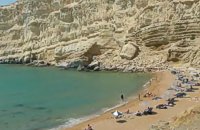 Matala, South - West Iraklion at 45.9km (SW) The Red beach is located around 700m south from Matala. It is a beautiful secluded beach with fine reddish sand originating from the rocks of the area. The name "Red Beach" is given by the visitors due to its reddish color while its original name is Ammoúdia (GR: Αμμούδια). The sea gets a lovely blue-green color, making the landscape really unique. The only way to access Red Beach is on foot or by boat from Matala. The walk from Matala takes about 20 minutes and it can't be considered as an easy one. Red Beach however can get pretty crowded in the high season. There is a small stone-wall canteen offering snacks and drinks and a few umbrellas and sun-beds. Nudism is tolerated at the two ends of the beach. Image Library
 Rethymnon North at 46.8km (W) Adele village is at a distance of approximately 8 Km east of Rethymnon town located on the road to the Monastery of Arkadi. It is a beautiful small village built in an altitude of 70m above sea level with a population of 350 people. Strolling around the village, through the narrow paved small streets the visitor will come upon beautiful picturesque house yards, freshly whitewashed houses, historical churches and tasteful traditional coffee shops.
 freedom fighter born in Adele at 46.8km (W) Kostis Yiamboudakis was the hero who ignited a fire in the gunpowder storage room of the Arkadi Monastery in November 1866 and won glory for himself and the island of Crete. He was a simple villager with a big heart and great love for freedom.
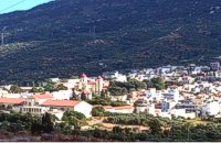 Mirabello, Lassithi at 48.8km (E) Neapolis is located 15 km westwards of Agios Nikolaos on the way to Heraklion from where it is roughly 50 km far. Neapolis is built in the green valley of Mirabello. In the period of the Venetian domination its two settlements were named "New Village". But when the seat of the Prefecture was transferred from Fourni to the “New Village” this last was renamed to Neapolis. Neapolis was maintained as the capital of the prefecture of Lasithi till 1904. After that date Agios Nikolaos became the new capital. 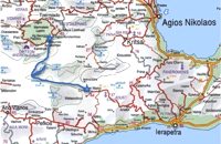 by Richard Ellis at 48.9km (SE) It was a familiar performance trying to find the right path out of Selakano. T's map v T's GPS (didn't show the start) v LW's words. Together they made no real sense, because the map was saying that the footpath ran due west out of Selakano while LW’s suggested route was taking me north. In the end good old red paint splashes got me going westwards along a concrete path (starting beside a concrete structure) not far north of the junction between the bunkhouse square and Stella’s taverna. You have to follow your nose here as the paths stop and start a bit, but the GPS did clutch in quite quickly and, as ever, was reliable. Distance:22km Time: 9 hrs. Mov av 3.4 km/hr Height overnight: 824m.(max 2,148m.) 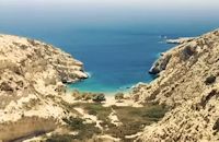 South - coast Iraklion at 49.5km (SW) Martsalo (GR: Μάρτσαλο, Mártsalo) is located on the mass of the Asterousia Mountains between Kefali (Cape Lithino) and Agiofarago. It is an impressive gorge about two kilometers long, which belongs to the hermitages of the Holy Monastery of Odigitria. Inside the gorge there is rich vegetation as well as a small palm forest in the middle of its route. The impressive cliffs are home to a large number of caves (similar to eagles' nests) inhabited by many of the area's ascetics. Gorge Martsalo is particularly steep and rough and ends at the Libyan Sea, where there is a small protected cove with a sandy- pebbly beach. Image Library
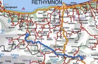 by Richard Ellis at 49.5km (W) 27th August - I set off from Spili at 0740 under a rather cloudy sky and with a cooling breeze to keep me feeling fresh. Today was always going to be a bit of a road slog and the first few kms to Mixourama was on the main road with cars flashing by. The GPS suggested that there was a road link between Koxare and Agouseliana even though there was nothing on the paper map so, after 6 or 7 kms, I cut across to Koxare. Distance: 32 km Time: 8 hrs. 25mins. Mov av 4.8 km/hr Height overnight: 272m. 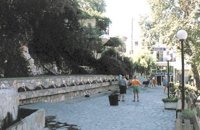 Spili, Rethymno at 49.7km (W) Spili (GR:Σπήλι) is 30 km away from Rethymnon, along the road that goes from Rethymnon to Armenoi and then Spili. The town has about 800 inhabitants and it lies at a height of 430 m above sea level, at the foothills of Mount Vorizi, which belongs to the Kedros chain. The landmark of the town is the square at Kefalovrissi with the 25 fountains each one in the shape of a lion's head. The square is named after Thanassis Skordalos (1920-1998), a popular lyra player and composer born in Spili. Spili is a modern town, with all the facilities and services required by the locals and by the large number of visitors. Image Library
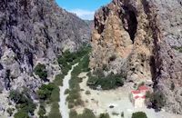 South - coast Iraklion at 49.7km (SW) Agiofaraggo (GR: Αγιοφάραγγο the gorge of Saints) is a small gorge at the southern shores of Heraklion close to the village and the beach of Kaloi Limenes and 6 kilometers south of the Monastery of Odigitria. Image Library
|
||
|
| ||
C
O
N
T
E
N
T
S
O
N
T
E
N
T
S


