interkriti®
YOUR GATEWAY TO CRETE
HOME
CRETE FACTS
NAVIGATE
EXPLORE

Agia Galini
Triopetra
Kissamos
Chryssi Isl.
Agia Marina
Balos
Gavdos isl.
Georgioupolis
SAMARIA
IDA Mtn
Palaiochora
Agia Roumeli
Sfakaki
Bali
Kalamaki
Matala
Lassithi
Plateau Lendas
Tsoutsouros
Vianos
Myrtos
Sfakia
Plakias
Ierapetra
Makrygialos
ZAKROS
Vai
Sitia
Agios Nikolaos
Elounda
MALIA
Hersonissos
Gouves
Chania
Rethymnon
Heraklion
GORTYN
FESTOS
KNOSSOS
|
|
Crete
List Grid Map
Found
250
- Showing :
21 - 40
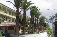
 Archanes at 11.1km (E) An excellent specimen of a specialized building, one of the first structures erected during the period of the Cretan State. It was designed by the architect Salivero, one of Prince George's officials. The plans were completed in 1901 and the construction was accomplished thanks to donations of rich Archanians living in the U.S.A. The building is Pi-shaped in plan, has two storeys and a basement, it is built of stone and its roof is partially wooden and covered with tiles. It is a monumental but well balanced structure with many harmonic and elegant Neoclassical features. Since its construction, the building has been used as a school. During the German occupation it housed General Muller's division. Source: The Hellenic Ministry of Culture  Archanes at 11.1km (SE) The Minoan villa at Vathypetro was most likely the residence of a local ruler. Its architecture is comparable to that of a "Little Palace": it has a central and west court, a small tripartite shrine, a three-columned portico, storerooms and workshops. It seems that the construction of the building was never completed. Interesting elements of its architecture are the installations of a wine-press in the south wing and an oil-press in the courtyard.  Archane, Iraklion at 11.1km (E) The Archaeological Museum of Archanes opened in 1993. It occupies an area of 570 square meters and it is located at the Tzami quarter in the center of the settlement. There, for the first time in Crete, the archaeological finds from a single site are exhibited. While the exterior spaces of the building were adapted to a tasteful ensemble, in resemblance with the impressive modesty of the environment and the traditional ochre and rosy colour tonations of Archanes. The interior was thus arranged as to accommodate the most modern mode of exhibition, especially attractive for the visitor.  Kenourgiou, Iraklion at 11.3km (S) Agios Thomás (GR: Αγιος Θωμάς) lies at 530 m above sea level. It is 30 km away from Heraklion and has a panoramic view over the whole area to the SE of Aghia Varvara. Agios Thomas is a very old village and the first reference we have of it, is in a document of 1371, where it is quoted as a feudal property of Petrus de Medio, and again in a document dated 1380. Later, it figures in all the Venetian censi of the 16th and 17th centuries. In 1881, and in 1900, it figures as part of the Megali Vrisi municipality, with 344 inhabitants. From 1920, it figures in all the censi as a community with a continuously growing number of inhabitants. Nowadays there are over 800 inhabitants.  Archanes, Iraklion at 11.6km (E) A small traditional town (~4000 people) 15 km south of Iraklion on the foot of the sacred mountain Yiouhtas. Renowned for its excellent wine (from the varieties: vilana, kotsifali and madilari) and the archaeolocical sites and caves. In 1912, Xanthoudides noted the importance of Archanes, but Sir Arthur Evans was the first to characterize the site as palatial, declaring that Archanes was likely a Summer Palace for the Knossos kings. Spyridon Marinatos and N. Platon excavated minor areas in the region, but nothing supported Evans' theory. In 1964, J. Sakellarakis dug trial trenches at the Tourkoyeitonia site and uncovered the first evidence of a palace site. Since 1966, Archanes has been excavated by the Greek Archaeaological Society under the supervision of John Sakellarakis and Efi Sapouna-Sakellarakis. The small town of Epano Archanes, one of the most famous places of the Cretan land, with its colorful courtyards, teaches culture, taste, tradition, colors, aromas and life itself. The silvery grays of the olive groves, the red, pink, salmon and tiled walls, the blue and green shutters, the colorful bougainvillea boldly climbing the walls of the houses, the manicured flower beds, but also the elaborate, colorful signs in coffee shops and grocery stores. All this makes Archanes the most colorful village of Crete, but also of Greece. The town is full of atmospheric neighborhoods with well-maintained houses, painted in cheerful colors. At each step the visitor learns more and more about it. That's why the locals have taken care of it: the Folklore Museum, the Archaeological Museum, the sculpture workshop, the Museum of Cretan History and Tradition just outside. Image Library
 Iraklion at 11.6km (NE) Capacity: 26,240 (seated)- Location: The stadium is located in Heraklion (also: Iraklio) 3 km west of the city centre (at Lido beach)... The building began 15 years ago and the 2004 Olympic Games proved to be the golden opportunity for the Pancretan, as the Athens Organising Committee named it as one of the venues of the football tournament. It was inaugurated on 31 March 2004, when it hosted an international friendly match between the National teams of Greece and Switzerland. The stadium is currently the second largest stadium of the country. The stadium is actually part of a sports complex. A training ground with an 8-lane athletics track, Lido Indoor Hall, and a swimming pool are located right next to the Pancretan Stadium. Image Library
 Kenouriou, Iraklion at 11.6km (S) Doúli (GR: Δούλι) is a village in Kenouriou county, located 38 km from Iraklion at an altitude of 440 m above sea level. The earliest reference to it, is to be found in the Duke's Archives of 1372, where it is mentioned as the feudal property of Nic. Venerio. The name figures in all the Venetian censi of the 16th and 17th centuries, as well as in the Turkish (1671) and Egyptian (1834) censi. In 1881, Douli forms part of the municipality of Megali Vrisi with about 170 inhabitants, and again in 1900 with only 21 inhabitants. As of 1920, Douli is a commune in its own right, and today Douli has about 240 residents. The patron saint of the village is Aghios Panteleimonas and the feast of the Saint is celebrated on July 27th.A visit to the old church of Aghios Nikolaos is also a must. For those interested in paleontology, there are fossils to be found at the location 'Pirgos'.  Iraklion at 11.8km (NE) Established in 1927, AGRUNION is one of the largest agricultural cooperative unions of Greece, with 167 members of 1st degree and over 47.000 members (farmers). Its range of products include olive oil, wines, vinegar and table grapes, sold into the Greek and foreign markets. They are produced in new-built factories equipped with foremost technological equipment, totally owned by AGRUNION.  North - Central Crete at 12.2km (NE) Iraklion (Heraklion or Herakleion GR: Ηράκλειον) is the largest urban centre in Crete, the capital of the region and the economic centre of the island. The first European civilisation, the Minoan civilisation, flourished on this land 5000 years ago. Currently the population of Iraklion is approximately 150.000 people. It is a very dynamic and cosmopolitan town, particularly during the summer period when thousands of visitors can be seen shopping in the market or visiting the museums and other places of interest. Today Heraklion is the top choice for tourist destinations in the Mediterranean. The city is also the commercial and scientific centre of the island. During the last 20 years the city has made remarkable progress in the academic and technological fields...
Image Library
 Knossou Av. Iraklion at 12.3km (NE) The General Hospital of Heraklion "Venizeleio & Pananio", named after the great statesman Eleftherios Venizelos, is one of the largest hospitals in Crete with 500 organic beds. It is located 4km away from Heraklion center on the road to Knossos, and occupies an area of 25,000 sq. meters. Venizeleio hospital provides high quality health services to citizens in a friendly and human environment. It was established in 1953 by a donation of Cretans of America and worked initially for Pulmonary Diseases. It was for many years the major hospital in East Crete. Telephone: (+30) 2813 408000 Website: www.venizeleio.gr/  Malevizi, Iraklion at 12.3km (NW) Dóxa (GR: Δόξα) is a pretty village built on a height of 400 metres above sea-level and 20 kilometres to the west of Heraklion on the road to the mountainous Milopotamos. The historical cave of Dóxa (GR: Δόξα) is located in a short distance from the village of Marathos on the road to Heraklion. It is at a height of 490 metres above sea-level, near a well-known taverna also called DOXA. The cave has a total length of 50 metres and impressive stalactites and stalagmites. 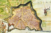 Iraklion at 12.5km (NE) The fortified enclosure of the Venetian Chandakas of the 15th century, which is still preserved today, is one of the most significant monuments of its kind in the whole Mediterranean basin. Triangular in shape, with its base at the sea, the mighty enceinte has a perimeter of about 5.5 kilometres. The hallmark of the defensive layout are the bastions, linked by curtain walls decorated at many points by escutcheons and the lion of St. Mark, symbol of Venetian omnipotence. The gates in the enceinte, which served to link the town to the countryside, still stand as important architectural monuments. To this day, the walls that withstood the Ottoman siege in the mid-17th century mark out the boundary of the old town. 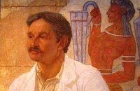 Excavator of Knossos at 12.5km (S) British archaeologist whose name is inextricably bound up with excavations and restoration work at the palace of Knossos. Born as the son of numismatist John Evans, he studied at Oxford and briefly in Göttingen. From 1875 to 1882 he travelled through the Balkans as a correspondent of the Manchester Guardian. In 1884 he was appointed curator at the Ashmolean Museum in Oxford, which post he held until 1908. One year later he became a university don. In 1894 Schliemman's excavations at Troy, Mycenae and Tiryns prompted Evans to visit Crete for the first time, in search of Bronze Age script. The following year he published his first book on Cretan pictographics and pre-Phoenician writing. He set about systematic excavation work after the island was liberated from the Turks (in 1898), having already located the wider area in which to dig. At the same time he toured the length and breadth of Crete. Evans worked at Knossos for no less than 35 years, bringing the palace and countless finds to light. The building's large surface area and shape led him to the conclusion that it had been the palace of King Minos. He thus gave the name 'Minoan' to the civilization he had uncovered, subdividing it into three major periods. In 1911 he was knighted for his excavation activity and extensive work. Alongside the excavations, Evans showed great zeal in restoring the palace and reconstructing the wall paintings that had come to light. For all the intense criticism this part of his work has often attracted, it still stands as a first approach to what is now known as the Minoan palace. The ensuing publications of material added many pieces to the puzzle of Minoan civilization and remain useful research tools to this day. In the course of his last visit to Crete, Evans was given the Freedom of the City of Heraklion. Image Library
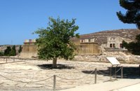
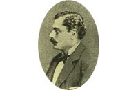 Discovered Knossos at 12.5km (S) Born in 1843 as the youngest son of Andreas Kalokairinos. Having completed secondary education on the island of Syros, he matriculated at the University of Athens School of Laws and attended for one year, but was forced to abandon his studies after his father fell seriously ill and died. Thereafter his interest turned to his father's estates, which he initially managed together with his brother Lysimachos. Kalokairinos later went into soap manufacture, winning awards at world exhibitions. Unfortunately, however, his business enterprises were not destined to be successful to the end; in 1895, having taken out numerous loans at exorbitant interest rates and mortgaged all his estates, he was forced to declare bankruptcy and was thus deprived of the right to engage in commerce. In 1903 he decided to resume his legal studies at university, and was later awarded a a degree. In 1878 his passion for archaeology and classical studies led him to attempt the first systematic excavations at Knossos, which brought the first finds from the Minoan palace to light. These comprised the Kalokairinos private collection, held at the site where the Kalokairinos Mansion (the present-day Historical Museum of Crete) was later built. The finds were destroyed when the first mansion was burnt to the ground during the 1898 riots. In 1869 Minos Kalokairinos married Skevo Kyriazi, with whom he had five children. 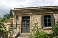 Knossos at 12.5km (S) Villa Ariadne was built at Knossos, Crete, by Sir Arthur Evans soon after he discovered the Minoan palace, when the site was his own private property. The villa became home, in turn, to John Pendlebury, who used it as a base for his excavations at Knossos and his explorations of the island. After Pendlebury's death at the hands of invading German paratroopers, the Villa Ariadne was taken over by General Karl Kreipe, who was living there when he was kidnapped by Patrick Leigh Fermor and his team. Ariadne villa is surrounded by the only existing Greek Edwardian garden, a large oasis of Cretan and other flora and shrubs in specific formations. The garden has been fully studied by the British School of Archaeology with the participation of special architects and agronomists from Heraklion.  Palace and Archaeological site at 12.6km (NE) The famous Palace of king Minos and the centre of the Minoan civilisation 5km south of Iraklion. The Great Palace covered an area of 20.000 sq. meters and had 1.400 rooms. Every section of the Palace had a specific use. In the west side of the Palace were the chambers of the ceremonies, of the administration and of the public storehouse...
Image Library
 Kenourgiou, Iraklion at 12.6km (S) Agia Varvára (GR: Αγία Βαρβάρα) is a town built along the road between the Messara plain and the Malevizi region at the highest point (580 m). The town enjoys a unique location with a splendid view into the Malevizi region, and a cool climate, particularly pleasant during the hot summer months. It produces first-rate fruit and vegetables. Because of its strategic location on the main north-south axis, the town was often exposed to fierce battles. A famous warrior, Mathiou Kapitakis or Mathioudakis was born here: he fought side to side with Karaiskakis and was killed at Faliro. His comrade-in-arms, Logios, was the hero of Aghios Thomas. As you reach the village, on the north side there is a rock with a chapel dedicated to Profitis Ilias. On this rock -which used to be twice as large but part of it fell off at the beginning of the 19th century- there used to be an ancient temple. Nowadays, the visitor can find every kind of commodity and facility on hand at the modern town of Aghia Varvara. In summer a special 'tsikoudia' feast, and in early spring a carnival feast are organized by the Cultural Association of the town. At the centre of the town, there are two churches - one old and one new - both dedicated to the patron saint, Aghia Varvara. Three Byzantine churches are also well worth a visit: Profitis Ilias, Aghios Giorgos and Aghios Ioannis, and of course the old monastery of Aghia Pelagia by the cemetery.  Iraklion at 12.6km (NE) The bastion heart shaped in plan with an acute angle, has two "piazza bassa" and one cavalier. It defines the southeast and the highest part of the fortification. Its name is due to Gabriele Tadini Martinego (1520) who started the construction of a circular tower at the place of the later bastion. It was one of the strongest bastions (the others were that of Pantocratora and that of Vittouri) which also suffered the main attack and most of the bombardment from the Turks. On the top of the bastion itself there was made a cavalier (which looks like a smaller bastion), whose main purpose was the better defense and control of the area around the bastion. The grave of Nikos Kazantzakis, the famous Cretan writer, is situated on the highest point of the Venetian fortification at the Martinego cavalier. The inscription by the wooden cross reads: " I hope for nothing. I fear nothing. I am free ", a phrase taken from "The Odyssey" which Kazantzakis considered as one of his most significant works. The playgrounds of the Academy of the local football team "Ergotelis" are located today on the main bastion and in the ditch around the bastion are the botanical gardens of the city. Image Library
 Knossos Palace at 12.6km (S) The court is crossed by the so-called "Processional Causeways", which stand out from the rest of the paving and intersect each other. One idea is that processions paraded along them during ceremonies. The West Facade of the Palace rises up along one side. The facade is constructed of massive gypsum blocks (orthostats) set on a plinth. The facade is indented or protrudes corresponding to the interior arrangement of space. In front of the West Façade, two bases can be seen, thought to belong to stone-built altars. Settlement remains of the Neolithic (6700 - 3200 B.C.) and pre-palatial (3200 - 1900 B.C.) periods have been found beneath the level of the "West Court". Image Library
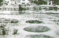 Knossos Palace at 12.6km (S) Three large pits, known as "kouloures" (rings), with stone-lined walls were built in the West Court during the Old Palace period (1900-1700B.C.). The excavation workmen gave them their name and A. Evans kept it. The function of the circular pits is not clear. They have been interpreted as rubbish dumps either for all the refuse from the Palace or just the left-overs from sacred offerings. Support has also been given to the idea that they were storing grain. In two of them, it is possible to see the remains of houses of the Pre Palatial period (3200-1900 B.C.). In the New Palace period (1700-1450 B.C.),the "kouloures" were covered over and out of use. Image Library
|
||
|
| ||


C
O
N
T
E
N
T
S
O
N
T
E
N
T
S