interkriti®
YOUR GATEWAY TO CRETE
HOME
CRETE FACTS
NAVIGATE
EXPLORE

Agia Galini
Triopetra
Kissamos
Chryssi Isl.
Agia Marina
Balos
Gavdos isl.
Georgioupolis
SAMARIA
IDA Mtn
Palaiochora
Agia Roumeli
Sfakaki
Bali
Kalamaki
Matala
Lassithi
Plateau Lendas
Tsoutsouros
Vianos
Myrtos
Sfakia
Plakias
Ierapetra
Makrygialos
ZAKROS
Vai
Sitia
Agios Nikolaos
Elounda
MALIA
Hersonissos
Gouves
Chania
Rethymnon
Heraklion
GORTYN
FESTOS
KNOSSOS
|
|
Crete
List Grid Map
Found
22
- Showing :
21 - 22
 White Mountains, Hania at 29.2km (SE) The famous - mainly due to the gorge of Samaria- plateau of Omalos (GR: Ομαλός) is surrounded by the high crowns of the Lefka Ori (White Mountains) at 1,040 to 1,250 meters and is just 38 km from the town of Chania. It extends to the counties of Sfakia, Selino and Kydonia in the prefecture of Hania. Its shape is nearly rectangular with a perimeter of about 25kms and a diameter of approximately 4 kms. It can be reached by car from the north (Neratzoporo) and from the south (Agios Theodoros).
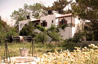 Paleohora at 29.8km (S) Villa Anna is located 100 m. from beach. Villa Anna consists of two separate buildings (each comprising four apartments), surrounded by a rich garden of 2000 sq. m. The apartments are all fully equipped with appliances and comforts: kitchen (complete with fridge/freezer, oven/cook, pots/pans and cutlery), bathroom, living room with TV, A/C and one or two bedrooms. Ideal for comfortable vacations and relax.
|
||
|
| ||


C
O
N
T
E
N
T
S
O
N
T
E
N
T
S
| Page Contents |
|
Top
|