interkriti®
YOUR GATEWAY TO CRETE
HOME
CRETE FACTS
NAVIGATE
EXPLORE

Agia Galini
Triopetra
Kissamos
Chryssi Isl.
Agia Marina
Balos
Gavdos isl.
Georgioupolis
SAMARIA
IDA Mtn
Palaiochora
Agia Roumeli
Sfakaki
Bali
Kalamaki
Matala
Lassithi
Plateau Lendas
Tsoutsouros
Vianos
Myrtos
Sfakia
Plakias
Ierapetra
Makrygialos
ZAKROS
Vai
Sitia
Agios Nikolaos
Elounda
MALIA
Hersonissos
Gouves
Chania
Rethymnon
Heraklion
GORTYN
FESTOS
KNOSSOS
|
|
Crete
: History & Archaeology
List Grid Map
Found
50
- Showing :
21 - 40
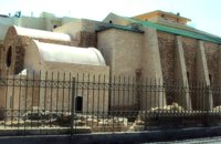 Iraklion Old Town at 16.7km (W) It is situated approximately in the middle of the seaside wall. It was built from the first years of the venetian domination and belonged to the monastic order of Dominicans (Domenicani Predicatori). It was one of the most important and biggest Catholic monasteries of the city. The earthquake of 1508 caused a lot of damages to the temple. It consists of a long aisle which is roofed by a two slope roof and ends at a sanctuary roofed by two vaults. To the north and south wall of the temple there are windows of different types that were opened either during the Turkish period, or even earlier. Image Library
 Iraklion at 16.8km (W) The «General Provisioner» Antonio Priuli made it in 1666 and it is situated today behind the "Bodosakeio" Primary School (in the area of the Venetian Dermata Gate). He decorated it with round and square columns with Corinthian type capitals, while a triangular pediment crowns the whole construction. From both sides of the columns there are niches with their metopes elaborately decorated. In the middle of the fountain there is a Turkish inscription where there is a reference to the name of the Turkish pasha who managed to bring water again in the fountain.
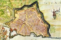 Iraklion at 16.9km (W) The fortified enclosure of the Venetian Chandakas of the 15th century, which is still preserved today, is one of the most significant monuments of its kind in the whole Mediterranean basin. Triangular in shape, with its base at the sea, the mighty enceinte has a perimeter of about 5.5 kilometres. The hallmark of the defensive layout are the bastions, linked by curtain walls decorated at many points by escutcheons and the lion of St. Mark, symbol of Venetian omnipotence. The gates in the enceinte, which served to link the town to the countryside, still stand as important architectural monuments. To this day, the walls that withstood the Ottoman siege in the mid-17th century mark out the boundary of the old town.  Archanes at 17.3km (SW) The Minoan villa at Vathypetro was most likely the residence of a local ruler. Its architecture is comparable to that of a "Little Palace": it has a central and west court, a small tripartite shrine, a three-columned portico, storerooms and workshops. It seems that the construction of the building was never completed. Interesting elements of its architecture are the installations of a wine-press in the south wing and an oil-press in the courtyard.  Psychro, Lassithi Plateau at 19.5km (SE) The cave of Psychro is one of the most important cult places of Minoan Crete. The excavators and several scholars identify the cave as the famous "Diktaian Cave", where Zeus was born and brought up with the aid of Amaltheia and the Kouretes, and which is connected with myths as this of the seer Epimenides who "slept" here, or the coupling of Zeus with Europa.
 Lassithi, Dikti Mountains at 21.1km (SE) The Lassithi Plateau (GR: Οροπέδιο Λασιθίου, Oropedio Lasithiou), is a high endorheic plateau, located in eastern Crete, Greece on the mountain range of Dikti at an average altitude of 840 m, and in a distance of around 55km from Heraklion and 50km from Agios Nikolaos. The plateau is elliptical in shape with an E-W axis of 11km and the N-S of 7km. The plateau of Lassithi is renowned for its exceptional agricultural produce, the thousands (almost 15000) windmills that used to be there in the past, its significant historical role and for the unique cave of Psychro also known as "Diktaion Andron". Image Library
 Tylissos at 26km (W) The houses of Tylissos were built during the LM I period (16th-15th century B.C.). Additions were made on House A in the LM II (15th-14th century B.C.) and on House C during the LM III period (14th century B.C.). The site was destroyed by fire in the 14th century B.C. and re - inhabited in historic times as is attested by ruins of later houses over the Minoan ones. Tylissos was excavated by Joseph Chatzidakis in 1902-1913. In 1954, in the course of restorations, parts of a paved court were revealed to the west, and a small stoa with five columns to the north of the Square of the Altar. The monuments were restored by the Archaeological Service (under the direction of Nicolaos Platon) in the period between 1954 and 1962. All three houses were again restored in 1990-1994. Source: The Hellenic Ministry of Culture  South east Iraklion at 28.7km (S) Historical place with outstanding natural beauty, unspoiled villages and great beaches. The town of Ano Viannos is built amphitheatrically on the southern slopes of Dikti mountain at 560 m. above sea in a distance of 65km from Iraklion and 40km from Ierapetra. It preserves the traditional character with the narrow paved streets, the stone built houses - especially the "Plaka' quarter - the old kefeneios with tables under the plane trees and old churches such as Agios Georgios and Agia Pelagia with wall paintings dating back to the 14th century. There are a few accommodation facilities, banks, medical center, taverns, gas stations, shops etc. Ano Viannos is the seat of the municipality of Viannos.
 Kenourgiou, Iraklion at 29.9km (SW) Agios Thomás (GR: Αγιος Θωμάς) lies at 530 m above sea level. It is 30 km away from Heraklion and has a panoramic view over the whole area to the SE of Aghia Varvara. Agios Thomas is a very old village and the first reference we have of it, is in a document of 1371, where it is quoted as a feudal property of Petrus de Medio, and again in a document dated 1380. Later, it figures in all the Venetian censi of the 16th and 17th centuries. In 1881, and in 1900, it figures as part of the Megali Vrisi municipality, with 344 inhabitants. From 1920, it figures in all the censi as a community with a continuously growing number of inhabitants. Nowadays there are over 800 inhabitants.  Mirabello, Lasstithi at 34.2km (SE) Lato (Gr: Λατώ) was an ancient city of Crete, the ruins of which are located approximately 3 km from the small town of Kritsa. The Dorian city-state was built in a defensible position overlooking Mirabello Bay between two peaks, both of which became acropolises to the city. Although the city probably predates the arrival of the Dorians, the ruins date mainly from the Dorian period (fifth and fourth centuries BC). The city was destroyed ca. 200 BCE, but its port (Lato Etera or Lato pros Kamara), located near Agios Nikolaos was in use during Roman rule. There is some suggestion that the city was named after the goddess Leto (of which Lato is the usual Doric form) and may be mentioned in Linear B tablets as RA-TO. Lato also minted coins in antiquity,[3] bearing the likeness of the goddess Eileithyia who appears to have been the one particularly worshipped at Lato. Nearchus, admiral of Alexander the Great, was born at Lato.  Monofatsi, South Iraklion at 34.8km (S) Tsoutsouros (GR: Τσούτσουρος) is a small village on the southern coast of Iraklion prefecture, with lovely beaches and a small harbour. The ancient city of Inatos, used to stand were Tsoutsouros is now. Inatos served as a port to Priansos a renowned city - state of the Hellenistic time, located near the village of Kasteliana. Tsoutsouros is a popular tourist resort especially with Greek families. There are many taverns and cafes most of them around the small harbour, and a good choice of apartments and hotels along the beach. Image Library
 Mirabello Bay, Lassithi at 37.8km (E) The area is touristic developed with many shops, restaurants on the shore, bars and several excellent hotels famous for their comforts and the variety of amenities offered. The lagoon of Elounda is shaped between the coast and a small peninsula of 7-8 km length ... Spinalonga, since antiquity, has protected the harbor of ancient Olous.
 Agios Nikolaos, Lassithi at 38.7km (E) The Archaeological Museum of Aghios Nikolaos is one of the most important in Crete and has been in operation since 1969. It houses collections of very important archaeological finds from the whole of Eastern Crete, an area extending from Malia as far as Zakros. These are displayed in chronological order from the Neolithic period (5700 - 2800 B.C.) to the end of the Roman times (100 B.C. - 400 A.D.) Its showcases include more than 1350 vases from the 3rd millennium B.C. as well as gold and copper finds (the most ancient found in Crete).
 Milopotamos, Rethymno at 38.8km (W) Anogia is a mountain town with 2500 permanent residents and is 55 km away from Rethymnon and 36 km from Iraklion. The name Anogia, means "high place - Ano Gi", is connected with the location that is built, in altitude of 700 m. Hospitable and pleasant residents have to tell a lot of old stories that have marked the tradition and the culture of the village. Anogia is a well-known village historically for its resident's resistance to the conquerors, Turkish and Germans.
Image Library
 Elounda, Mirabello bay, Lassithi at 38.9km (E) The island of Spinalonga (Gr: Σπιναλόγκα), officially known as Kalydon (Καλυδών), is located in the Gulf of Elounda in north-eastern Crete, in Lasithi prefecture, next to the town of Elounda. The official Greek name of the island today is Kalydon. Originally, Spinalonga was not an island, it was part of the island of Crete. During Venetian occupation the island was carved out of the coast for defense purposes and a fort was built there. A popular name for the island since Venetian rule is Spinalonga. During Venetian rule, salt was harvested from salt pans around the island. The island has also been used as a leper colony. Spinalonga has appeared in novels, television series, and a short film.
 Gortyn archaeological site at 41.9km (SW) According to the myth, Zeus, disguised as a bull, coupled with Europe, whom he had brought from Phoenicia, under a deep- shaded plane tree on the banks of the Lethaios River. The offspring of this union were three sons, Minos, Sarpidon and Radamanthis. Later, the oldest Agora of the city of Gortyn, the Ekklesisterion (Congress hall), and the Roman Odeum were founded on this site. The plane tree was blessed and has remained ever green since that time. As his place of birth, the city was founded by King Minos himelf. According to the myth, it was on the fields of Gortyn that the bull given as a gift to Minos by Poseidon coupled with the Queen Pasiphae and out of this union Minotaur was born. Image Library
 Gortyn archaeological site at 41.9km (SW) The main acropolis of Gortyna was located on Agios Ioannis hill, to the northwest of the Agora. Acropolis can be accessed from its west side driving through Ambelouzos village to the direction of Gergeri. At a spot around 1.6 kms from Gortyna parking there is a footpath (not clearly signposted and maintained) that leads to the top of the hill. Once at the top you'll be rewarded by the magnificent view to the whole area and the archaeological site itself. The site was first inhabited in the Neolithic era and again at the end of Minoan times (1200 BC). Since then it was continuously inhabited until the Middle Byzantine period. From the first settlement only parts of walls, floors and hearths were preserved. In the 10th century BC a Geometric settlement was established fortified by a polygonal wall with towers at the corners. At the end of the 7th c. A.D., a small tripartite temple, dedicated to Athena Poliouchos was founded at the south side of the hill. From this temple some very important architectural sculptures were excavated. During the Early Byzantine period (5 - 6th century AD), a basilica was erected over the ruins of the geometric/archaic temple and, in the time of the emperor Heraclios (7th century A.D.) the last fortification with a castle in the center was built which still survives but in a very poor condition. Image Library
 Gortyn at 41.9km (SW) The Praetorium was the seat and residence of the proconsul of Crete. It is divided into two parts: the administrative section, in which the central building is the basilica, and the more "private" sector. The preserved ruins are dated to the 2nd century A.D. and seem to have been repaired in the 4th century A.D. This totally excavated building is the largest in the whole City of Gortyn. The earliest constructions have suffered successive alterations in a long period of eight centuries. New structures were erected on the ruins of the earlier sometimes incorporating parts of them. In the 1st c AD the Praetorium consisted of a peristyle court 1000 sq.m. and large halls to the north and west. This first Praetorium was destroyed by an earthquake in the time of the Emperor Trajan (early 2nd c AD). It was reconstructed and a large Thermai complex was built at its east side. Some years later a large temple dedicated to the Augusts was built further at the east part. To the west of the Thermai the juridical basilica continued to function under a judge’s responsibility according to the inscriptions found there, and statues of the emperors and other officers were still standing there. All these famous buildings were destroyed by the large earthquake in 365 AD. In 383 the consul Oecumenius Asclepiodotus Dositheus, agreeing with the capital of the empire, took care of the construction of the new Praetorium. Image Library
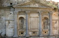
 Gortyn archaeological site at 41.9km (SW) The Great Nymphaeum (Nymphaion GR: Νυμφαίον), located to the north of Praetorium, was a marble construction with a covered cistern and fountains. Statues of Nymphs stood in the niches. The area of the remains is closed to the public but visitors can see it from a distance.
Image Library
 Gortyn archaeological site at 41.9km (SW) The sanctuary of the Egyptian deities (1st-2nd centuries A.D.) is the only one, in the whole island, which is dedicated to the Egyptian gods Isis, Serapis and Anubis - Hermes although it is known that those gods are worshiped in other cities. The sanctuary consists of quadrilateral nave, arcade on the west, underground crypt in the south and a cistern outside east of nave. In the central alcove stood the statue of Serapis and the side statues of Isis and Hermes - Anubis. In the southern part of the temple was oblong space, underground crypt purification and a small cictern. The final construction phase of the temple dates to the 1st / 2nd century. AD, in accordance with dedicatory inscription. Image Library
|
||
|
| ||


C
O
N
T
E
N
T
S
O
N
T
E
N
T
S