interkriti®
YOUR GATEWAY TO CRETE
HOME
CRETE FACTS
NAVIGATE
EXPLORE

Agia Galini
Triopetra
Kissamos
Chryssi Isl.
Agia Marina
Balos
Gavdos isl.
Georgioupolis
SAMARIA
IDA Mtn
Palaiochora
Agia Roumeli
Sfakaki
Bali
Kalamaki
Matala
Lassithi
Plateau Lendas
Tsoutsouros
Vianos
Myrtos
Sfakia
Plakias
Ierapetra
Makrygialos
ZAKROS
Vai
Sitia
Agios Nikolaos
Elounda
MALIA
Hersonissos
Gouves
Chania
Rethymnon
Heraklion
GORTYN
FESTOS
KNOSSOS
|
|
Crete
: Regional Interest
List Grid Map
Found
49
- Showing :
21 - 40
 Akrotiri, Chania at 25.4km (E) At the magical and historical location of Profitis Ilias, in Akrotiri, at the east of Hania lays the tomb of Eleftherios Venizelos, one of the most long-standing prime ministers of Greece and whose political life was focused on doubling the size of Greek territory and on the creation of a contemporary State. Eleftherios Venizelos himself had designated this position to be his resting place before his death. For the visitor, it affords a panoramic view of the rich green plain of Hania, the imposing White Mountains, the Cretan Sea, the town of Hania and the Chalepa quarter which is the location of the house in which the great politician spent most of his life and today is the headquarters of the National Research Foundation 'Eleftherios K. Venizelos'. Image Library
 White Mountains, Hania at 26.4km (SE) The famous - mainly due to the gorge of Samaria- plateau of Omalos (GR: Ομαλός) is surrounded by the high crowns of the Lefka Ori (White Mountains) at 1,040 to 1,250 meters and is just 38 km from the town of Chania. It extends to the counties of Sfakia, Selino and Kydonia in the prefecture of Hania. Its shape is nearly rectangular with a perimeter of about 25kms and a diameter of approximately 4 kms. It can be reached by car from the north (Neratzoporo) and from the south (Agios Theodoros).
 Lefka Ori, Hania at 29.1km (SE) Kallérgi Mountain Refuge is located on the western region of Crete, above the plateau of Omalos, in the White Mountains (Lefka Ori) mountain range at an altitude of 1680 metres. The site is of unique natural beauty and commands great views to the surrounding peaks and the gorge of Samaria. It can be accessed by car or on foot (1 1/2 hour) via the 5km long dirt road from Omalos. The refuge can accommodate up to 50 people. It features a fully equipped kitchen, a lodge with fire place and wood burning stoves, toilets (indoors and outdoors) and a camping area. Electricity is supplied by a generator. Kalergi refuge operates throughout the year (from November to March only on weekends) For more information please visit:Mountaineering Club of Hania  Selino, Hania at 29.3km (S) Elyros ("Έλυρος" in Greek) is an ancient city, located in southwest Crete, in Kefala Hill, near the village Rodovani and is presently unexcavated. Elyros was flourishing at least as early as the Greek Classical Period, e.g. 500 to 350 BC. In the Classical Period Elyros was the most important ancient city in southwestern Crete, having about 16,000 inhabitants. It was an industrial and commercial city with large weapons production. Syia and Lissos were its harbours. Apollo, Phylakides and Philandros, sons of Apollo and nymph Akakallida, were worshiped there. In the third century BC Elyros was at war with Kydonia, an important center of Cretan power, located in the modern city of Chania. The citizens of Elyros sent to the Delphi Oracle, a bronze votive complex that represents a goat feeding the sons of Apollo when they were infants. It is also one of the thirty cities that signed the decree with Eumenes B’ in 183 BC.Elyros was also important during Roman times. A Roman statue, the Philosopher of Elyros was recovered here and is now in the Archaeological Museum of Chania. During Byzantine times, Elyros was the seat of an Archbishop and the remains of the bishopric church, a sixth century basilica, can still be seen in the centre of the old city. Robert Pashley was the first who identified the location of the city, near village Rodovani. Thenon studied more carefully the ruins of the city and discovered the inscription that says: “it seemed to the city of the Elyrians”. The output of its mint consists of silver drachms from the 3rd c. BC, which depict a wild goat and a bee; in addition to their function as religious symbols, these undoubtedly hint at the stock-raising activities in the region, particularly to this kind of wild goat, which can still be found in great numbers on the island. The bee also has reference to the abundant honey-production of Crete.  Omalos, Hania at 29.7km (SE) Xylóskalo (Ksyloskalo GR: Ξυλόσκαλο) is the point where the Samarian gorge starts. It is located on the Lefka Ori (White Mountains) in the plateau of Omalos, 43 km from the city of Hania at 1250m above sea level. It is also the entrance to the gorge. There are two tourist lodges where visitors can rest and have food or coffee and take panoramic pictures of the gorge and the White Mountains. There is also the information center of the National Park and a parking area. Xyloskalo means the "wooden stair" and refers to a wooden staircase built by the locals in order to facilitate the entrance to the gorge as at this point the cliffs are very steep. Today this part of the path is made of stones and it has a wooden handrail. About 1km before Xyloskalo a dirt road leads, after 5 km, to the Kallergis mountain lodge at 1680m a.s.l.  Hania at 31.1km (E) A guide to the area of Akrotiri. Tourist facilities, regional information and image gallery. Akrotiri with its scenic landscape provides a relaxing, refined country break away from the pressures of urban life. Its numerous monasteries, from the oldest in Crete, played a significant role in the history of the area. Gorges of outstanding beauty offer a unique hiking experience, breathtaking views and the joy of exploration...
Image Library
 Sfakia, South Hania at 31.8km (SE) The Samaria Gorge is one of the longest ravines in Europe (with a total length of 16 km) and offers one of the most spectacular hiking routes in Europe. Its width ranges from 150 m (widest part) to 3 m (narrowest part). The walk from Xyloskalo in the plateau of Omalos to the shores of Libyan sea at Agia Roumeli, takes 6 to 8 hours. The Samaria Gorge has been designated as a national park in order to protect its flora and fauna. It is one of the last shelters of the mountain goat of Crete (Cretan Ibex, common name : kri-kri). The flora is extensive, ranging from high cypress trees to flowers and herbs. The walking path follows the river which flows to small lakes and waterfalls. The Gorge is open to visitors from May to October. Image Library
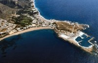
 Akrotiri, Chania at 32.8km (E) Chania International Airport, "Ioannis Daskalogiannis" (IATA: CHQ, ICAO: LGSA) is an international airport located 14km east from Hania, near Souda on the Akrotiri penisula. It is named after Ioannis Daskalogiannis, a Cretan revolutionary against Ottoman rule in the 18th century and is a joint civil - military airport (Souda Air Base). Access:By public bus and Taxi (~16 euros) Airport facilities: Police Station, Parking, Snack bar, ATM, Dutyfree, gift - souvenir shops, local nutrition products. Telephones:Information desk +30 28210 83800 - 83805  Coastal town in Selino, South Hania at 33.4km (S) The village of Souyia or Soúgia (GR:Σούγια) is located 75 km southwest of Hania at the southern coast of Crete a little to the east of Paliohora. Sougia is becoming very popular vacation place especially with nature lovers and walkers. There are some ancient sites around and Sougia itself was the port of the ancient town 'Elyros'. There are also quite a few accommodation properties and taverns, a great beach and a small port .
Image Library
 Ancient town in Selino, South Hania at 34.4km (S) Located ~2.3km west of Sougia it was the religious centre of the cities in south-west Crete and the port of Elyros. It flourished during the Hellenistic and Roman periods. In 1957-58 Asklepieion was excavated by N. Platon. The most important monuments of the site are: The Temple of Asklepios, dated to the Hellenistic and Roman periods, Part of a Roman theatre, Rock-cut and built chamber tombs. There two byzantine chapels dedicated to Our Lady and Agios Kirikos The beach in the small cove has coarse pebbles and clear waters. Lissos (GR: Λισσός) nowadays is uninhabited and can be reached from Sougia only by foot (~1& 1/2 hours walk) or by boat (~20 minutes). 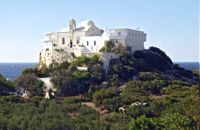 Hryssoskalitissa, Kissamos South West at 34.5km (SW) The monastery of Chryssoskalitissa (golden stair GR: Χρυσοσκαλίτισα) is dedicated to the Assumption of the Holy Mother and the Holy Trinity. It is located at the southwest part of Kissamos, 70km away from Chania. The fortress like monastery is built on a rock and pilgrims visiting have to follow a staircase carved on it with 98 steps. According to the tradition, the last one was made of gold but only faithful people could see it.
Image Library
 Selino, Hania South West at 35.6km (S) The pearl of the Libyan Sea! Paleochora (population~ 1500) is surrounded by mountains and is situated at the tip of a peninsular. Along the western side is a long sandy beach fringed by trees and tavernas. At the tip of the peninsular is the remains of an old Venetian (Selino Kasteli) fort and a marina. On the eastern side lies the old town, the ferry dock and a long pebble beach lined with tavernas. Paleochora becomes very busy during high season but still have places for those who want to get away from the crowd. Little boats are linking Paleohora with Agia Roumeli, Hora Sfakion and the small island of Gavdos. Regular buses per day are linking Paleohora to Chania (~75kms). Image Library
 Apokoronas at 37.3km (E) A flourishing traditional seaside town on the Apokoronas Peninsula 17km east of Hania. Kalýves (or Kalives GR: Καλύβες) with its old tiled stone houses, mixed with the latest buildings form two separate districts, with typical island style. Most of it is literally built on the sea and has 1289 residents. Xydás (GR: Ξυδάς) river that runs through the town, is giving it a unique character and a cool climate that prevents the heat of summer. In the square, you will see a traditional water mill built in the early 20th century, one of the oldest in the area. Kalives is tastefully developed for tourism, and welcomes many visitors during the summer season to its safe sandy beach. With comprehensive amenities, there are many shops, taverns and kafeneion, in addition to banking, post office and petrol station facilities.
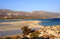 South west Kissamos at 38km (SW) Elafonissi is a small islet on the southwest of Crete. It is connected to the beach with a shallow reef (max. depth 1 meter) that allows crossing when the sea is calm. There are only a couple of cantinas on the beach and plenty of places for camping. The place can be accessed by car from the village of Vathi or by boat from Paleohora. There are no permanent inhabitants.
Image Library
 Sfakia, South Hania at 39.5km (SE) Agia Rouméli (GR: Αγία Ρουμέλη)is a small fishing village, approximately two kms from the ending of Samaria Gorge. It is accessible only by boat from Paleohora, and from Hora Sfakion. It serves mainly as a stopover for visitors coming down the Samaria Gorge, and waiting for the boat to take them to Sfakia or Paleohora. However those who decide to stay for a couple of days or more will find apart from the unique scenery, a great beach with crystal clear water, plenty of interesting walks and a good choice of accommodations, taverns, cafés and stores. The place is also rich in history as it was inhabited since the antiquity. It is the site of the ancient city of Tárra (GR: Τάρρα), a famous cult place, that flourished from the Classical to the Roman times. Image Library
 Apokoronas at 39.9km (E) A beautiful small sea side village with long sandy beach where wind surf, canoes, paddle boats, umbrellas and sun beds can be rented. The place provides all the facilities for the visitors with small hotels, rooms, apartments and many taverns with traditional food and fresh fish. Recent years it became very popular with expatriates and there is a significant development in the real estate sector.
Image Library
 Apokoronas, Hania at 40.7km (E) Pláka (GR: Πλάκα) is a lovely village in the Apokoronas area, less than one kilometer away from Almyrida, with interesting architectural style, which is unfortunately changing due to intense building mainly for tourist purposes. Its ~300 permanent inhabitants, occupying mostly with farming, stock-breeding, fishing and lately with tourism. It has all the basic amenities, including excellent tavernas, bars, a grocery store and a kafeneion. Plaka is built on the slope of a hill at 70 m above sea, with a panoramic view of the bay of Souda. The surrounding environment has maintained its character well and is ideal for walks either inland or along the coast. Visitors can also admire a magical sunset from here. Every summer -at about the end of July- a two days traditional feast - The Plakiana - is organized to honour the memory of the great local lyra player Mihalis Papadakis or else Plakianos. During the feast guests enjoy Cretan dances and can visit the textile and ceramics exhibitions. The custom of Klidonas is celebrated at the end of June and the Carnival usually takes place in March.  Apokoronas, Hania at 41.5km (SE) Vámos (GR: Βάμος) is the capital of Apokoronas district is an exceptionally interesting village that the Ministry for the Environment, Physical Planning and Public Works has classed as traditional. It is more like a small town, very well preserved, with folk and neoclassical architectural elements. The initiative of a group of inhabitants to create an association for the preservation of the village as well as alternative tourism strategies is already paying off while constituting a model for further local progress. The famous art and cultural festivals are good opportunities for everyone to experience the hospitality and entertainment Vamos can offer.
 Gavalohori, Vamos, Apokoronas at 41.6km (E) The exhibition of the objects takes place according to the contemporary museum conception, with explanatory texts, photographs, plans, models, and is enriched with new exhibits every year. The Museum is divided into seven rooms, according to the following units: The Arched House, Silk, Pottery, Lace-making, Masonry and Stone carving, Church and Woodcarving.
 Sfakia, South Hania at 41.7km (SE) Ágios Pávlos (GR: Άγιος Παύλος)is a beach on the shores of Sfakiá between Agia Rouméli and Loutró. The pine trees from the high cliffs above almost reach the sea and form a unique landscape. The beach is sandy with pebbles with no facilities except for a small tavern. It can be reached only on foot ( about 1 hour walk from Agia Roumeli) or by boat. The picturesque small church of Agios Pavlos (Saint Paul) a byzantine basilica of the 10th century A.D. with frescoes, lies just a few meters from the sea. It is built with stones from the beach itself on the spot where Saint Paul reportedly baptised people on his way to Rome.
Image Library
|
||
|
| ||


;)
C
O
N
T
E
N
T
S
O
N
T
E
N
T
S