interkriti®
YOUR GATEWAY TO CRETE
HOME
CRETE FACTS
NAVIGATE
EXPLORE

Agia Galini
Triopetra
Kissamos
Chryssi Isl.
Agia Marina
Balos
Gavdos isl.
Georgioupolis
SAMARIA
IDA Mtn
Palaiochora
Agia Roumeli
Sfakaki
Bali
Kalamaki
Matala
Lassithi
Plateau Lendas
Tsoutsouros
Vianos
Myrtos
Sfakia
Plakias
Ierapetra
Makrygialos
ZAKROS
Vai
Sitia
Agios Nikolaos
Elounda
MALIA
Hersonissos
Gouves
Chania
Rethymnon
Heraklion
GORTYN
FESTOS
KNOSSOS
|
|
Crete
: Regional Interest
List Grid Map
Found
95
- Showing :
21 - 40
 Ierapetra, Lassithi at 24.6km (SW) At a mountainous, precipitous site, in the west mountain slopes of Dikti, at an altitude of 550 m above sea level and at 2 km from the village of Malles, is built the village Christos (GR: Χριστός – Christ). Christos is a beautiful, verdurous village, with many running waters, traditional, unchanged by time, with narrow sloping cobbled alleys. Image Library
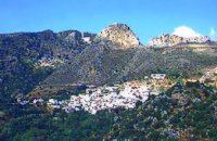
 Lassithi, Dikti Mountains at 24.8km (SW) The Lassithi Plateau (GR: Οροπέδιο Λασιθίου, Oropedio Lasithiou), is a high endorheic plateau, located in eastern Crete, Greece on the mountain range of Dikti at an average altitude of 840 m, and in a distance of around 55km from Heraklion and 50km from Agios Nikolaos. The plateau is elliptical in shape with an E-W axis of 11km and the N-S of 7km. The plateau of Lassithi is renowned for its exceptional agricultural produce, the thousands (almost 15000) windmills that used to be there in the past, its significant historical role and for the unique cave of Psychro also known as "Diktaion Andron". Image Library
 Ierapetra, Lassithi at 25.2km (S) The village of the rising sun, as its name declares. The golden rays illuminate Anatoli, the hanging rocks, the Holy Cross church, Drygies, Karkasa, and give the impression that the sun keeps rising. It is an old, historical, traditional village, situated at 17 km in the north-west of Ierapetra, at an altitude of 600 m. Its housesare visible from the plain and seem like white doves, nested in the fortified mountain of Anatoli. A privileged place, it has been a cradle of men of letters, Notaries, University professors, with great history and civilization.In the 70s, most of Anatoli’s residents got down to the plain and worked in the glasshouse cultivations. They founded, along with residents from other villages the settlementsStomio, Nea Anatoli, Ammoudares. The small picturesque village Kalogeroi, which, according to tradition, was built by a Turkish Aga, is part of Anatoli. It is referenced sincethe era of the Venetian rule. In 1583, along with Kalogeroi, it had 666 residents. In 1951 it had 897 and in 2001, along with Nea Anatoli, it had 1235 residents. The Tower of theVenetian feudal lord still lies in ruins in the north of the village. It nurtured important men of letters, such as Antonios Damilas, scribe and printer, Neilos Damilas, scholarlypriest-monk in the Karkasia Monastery, Dimitrios Damilas, brother of Antonios, scribe and printer in Milan, who published the “Greek Grammar” in 1476, Anthimos Donos,and Ioannis Olokalos, whose notary documents have been recently published. The latter had his seat in Drygies, a wonderful location in the east of the village with runningwaters, a tavern with a view of Ierapetra and the little church of Saint Foteini. Anatoli was an important intellectual center, having a school during the Venetian rule and a secretschool during the Turkish rule.The area of Anatoli, a fortified position, produced great fighters during the Turkish rule, such as Emmanuel Lakerdas, general chief of Ierapetra, Iakovos Mahairas, AthanasiosBarberakis and Georgios Bekiaris.Its history and struggles were imortant in all the historical periods. It has many ecclesiastical monuments, Monasteries and Byzantine icons of great art.The old traditional settlement of Anatoli has remained untouched by time, with its stone-built houses, the alleys, the old Kato Vrysi. Five years ago, it entered a program ofrenovation, was characterized as a traditional settlement and today houses and tourist lodgings of exceptional esthetics are built in stone. In a few years, Anatoli of Ierapetra willbe one of the most beautiful villages of Crete, with its wonderful climate, its extraordinary view, its incomparable natural landscape on which the Museum of Natural Historyof Crete has worked and about which it published a relevant document.Anatoli as well as its residents have to this day been successful in the agricultural, tourist and intellectual sectors. Personalities coming from the village dominate the political,social and intellectual life of our country. Anatoli was a Municipality in the beginning of the 20th century, then a Community and today a Local Department ofthe Municipality of Ierapetra, building its future on solid foundations. Hosting important cultural events, with itshistorical, folkloric and musical contributions, it is a center of attraction of bothlocals and foreigners. With two taverns, two coffee houses, a renovatedold school and hospitable residents, it satisfies the most demandingvisitors. Anatoli is even rich in snails and wild mushrooms.
 Ierapetra, Lassithi at 25.7km (SW) It is a small village with few residents, loacated 4 km to the west of the village Christos at an altitude of 600 m. The residents of Metaxohori (GR: Μεταξοχώρι, or Parsás - GR: Παρσάς) have immigrated to the plains of Ierapetra, in Stomio, Ammoudares and Xerokampos and work in the glasshouses. The village has been renamed in 1955 from Parsas to Metaxohori to honor the Ecumenical Patriarch Meletios Metaxakis who was born here.  Ierapetra, Lassithi at 27.1km (SW) A monument of natural beauty that attract a lot of local and foreign visitors. The gorge of Sarakina (GR: Σαρακίνα) is one of the most beautiful in Crete. Its steep, vertical walls in some parts reach a height up to 250 m. Its widest opening is no more than 15 metres while in some places it’s so narrow that its sides seem to join each other. Its rich flora and fauna, the dittany, the wild birds that nest there, the running water make the route through the gorge a worthwhile experience.  Psychro, Lassithi Plateau at 27.4km (SW) The cave of Psychro is one of the most important cult places of Minoan Crete. The excavators and several scholars identify the cave as the famous "Diktaian Cave", where Zeus was born and brought up with the aid of Amaltheia and the Kouretes, and which is connected with myths as this of the seer Epimenides who "slept" here, or the coupling of Zeus with Europa.
 Ierapetra, Lassithi at 27.6km (S) Ierápetra (GR: Ιεράπετρα), the southernmost town of Crete, combines a brilliant past with a present of economic growth and extension. The temperature seldom falls below 12°C, and the mean annual temperature is 20°C, also it is the sunniest and hottest region of Greece. It has a long sandy beach and clean blue sea, a picturesque port with the castle "Kales", an archaeological Museum, and many more attractions. Visitors will find a wide range of accommodation facilities and lots of interesting things to do and see in the town and the wider area as well.
Image Library
 Ierapetra, Lassithi at 28.1km (SW) Deep inside the valley of the river Sarantapihos is built the village Mythoi. It is 22 km away from Ierapetra, it is a small village, in a verdurous landscape,with a beautiful square under the shade of age-old planes. It is said that the village took its name from the plant “Minthi”, or mint, which is abundant there.However, it may have been named thus because of its many legends, traditions, and myths (mythoi), the most prevalent one being the Sarantapihos’ one. A mythical giant, forty ells tall, like another Talos or Akritas Digenis, he protected the residents from raids. There are the place names “Tou Sarantapihoui Patounia” (Sarantapihos’ footprint) and “Tou Sarantapihou to Mnima”(Sarantapihos’ grave). There is evidence of ancient habitation at the site “Leniko” where traces of walls can be seen. Also, in an excavation, the head of a woman of the Roman period has been found. At the sites Kastelou Haraki and Orfanou to Spiliari claypots, oil lamps, e.t.c. have been found. The site called Sarakina above Mythoi was a fortress, a hideout of Saracen pirates. The village’s modern history is rich in contributions to the struggles against the conquerors. It nurtured the chieftains Emmanouil Xenikakis, Ioannis Hatzakis, Emmanouil Christakis andothers. During the German Occupation, residents of Mythoi took part in the guerilla corpses of the United Resistance of Captain Bantouvas. In the battle of Symi, one of the most heroic figures was lost, Apostolos Vagionakis, who stood up to the enemy’s bullets for the ideals of our unsubdued Crete. They paid the price of their participation to the struggles during the German Occupation,as 4 persons were executed, including the old and bedridden Nikolaos Ioannou Christakis. The community of Mythoi is today a Local Department of the Municipality of Ierapetra, in 1900 it had 360 Christian residents, in 1951 it had 423 and in 2001it had 287. In the north of Mythoi, around 6 km away, there is the settlementKarydi with the famous Monastery of Panagia (Our Lady) Karydiani and now abandoned summer residences. The mountainous settlement “Minos”, which is situated in a verdurous small plateau below the Afentis peak of the Lasithi mountains, also belongs to the Community of Mythoi.The village Mythoi is a lively village with a rich social and cultural life. It has a cultural association, a football team and field, and a modern olive press. The village’s square with its old plane trees, the mulberry trees, the old fountain,the traditional coffee-houses with the raki and the local dishes, is a place of reference for the residents of Mythoi. The sights, the wild natural landscapes in the north of the village, the famous gorge of Sarakina, a monument of natural beauty, attract a lot of local and foreign visitors. The gorge of Sarakina is one of the most beautiful in Crete. Its steep, vertical sides cause awe, and reach a height of up to 250 m. Its widest opening is no more than 15 m while in some places it’s so narrow that its sides seem joined. Its rich flora and fauna, dittany,the wild birds that nest there and the route inside the gorge are breath-taking. Its promotion is a foremost goal of the Local Department and the Municipality of Ierapetra, of the residents of the village, who head to the future with optimism and anticipation for the development of their place. Source:The Municipality of Ierapetra.  Ierapetra town, South Lassithi at 28.3km (S) The museum was founded at the end of the 19th century, during the Turkish occupation of Crete and was housed in several buildings in the past. Today it is housed in the building of the Commercial Ottoman School, which is protected by a preservation order. The collection includes findings from the broader area and from the Minoan to the Roman period. Among the items are painted sarcophagi, lamps, vases, figurines, relief plaques. One of the most important exhibits of the museum is the Clay sarcophagus dated to 1450-1400 B.C.
Image Library
 Hersonissos, Iraklion, Crete at 28.5km (W) The Cretan Open-air Museum 'Lychnostatis' aims to promote the understanding and awareness of the Cretan folk cultural heritage. Its scope lies on the Cretan Folk Tradition and Ethnology, the Cretan Nature and Environment and the Cretan Folk Culture. Located in Hersonissos, one of the principal tourist areas in Crete, the museum is, apart from a valuable tourist asset, an exemplary self - motivated conduct on tradition, culture and environment of the island.  Ierapetra, Lassithi at 29.8km (SW) Mournies (GR: Μουρνιές - meaning: mulberry trees) is a village of the western Ierapetra. It is located north of Myrtos, and 25 kilometers away from Ierapetra at 275m (elevation), built on the southeastern outskirts of the Lasithi mountains, with beautiful views of the Libyan Sea and the plains of Ierapetra. It has a mild climate, without extremes, ideal both for permanent residence and for holidays. The landscape is hilly plenty of olive trees. In the 2001 census it had 83 residents. Mournies is a beautiful, historic, picturesque and traditional village with cafes, a square with a war memorial, an old fountain, and narrow streets branching off the main street of the village. Mournies was named after the Mulberry tree which however is not abundant in the area.  Ierapetra, Lassithi at 30.3km (SW) A small village built at an altitude of 540 m in the south parts of the mountain Dikti at the borders of the province of Ierapetra-Viannos. The imposing mountains above the village, the south horizon among the olive-covered hills and in the lower villages, the cool climate create in you a sensation of bodily and spiritual well-being at this balcony of the Cretan nature. Five settlements, two of them uninhabited today, constituted the Community of Riza, now a Local Department of the Municipality of Ierapetra.  Pediada, North - East Iraklion at 30.5km (W) The most popular tourist resort in Crete. Nice beaches, sights and facilities for all tastes and ages. Together with Malia, are the party places for young visitors. Close to Hersonissos there are three small traditional village, those of Piskopiano, Koutouloufari and Old Hersonissos.
 Pediada, Iraklion at 30.8km (W) Askoi (GR: Ασκοί) is small village in the municipality of Kasteli has 315 inhabitants. It lies in the foothills of the Dikti mountain, 11 km to the east of Kasteli and 8 km from Lyttos. Fr. Barozzi mentions it as Ascus, in the Pediada district, in 1577. Recently a ritual clay figurine of the Mid-Minoan period was fortuitously unearthed on a peak close to the village. The remains of a large building belonging to a peak sanctuary have been excavated at Amygdalokefalo to the NE of the village. A reference in a contract of 1271, mentions how Petri Comarii from the village (casali) Maski owes Ruggerino Temisano, resident in Chandax, 25 «mistata» of good Cretan wine from his vineyards in Maski. Among other natural beauties, the ravine at Aski is well worth seeing. On December 4th the village has a typical Cretan feast to honour Agia Varvara. And as in every Cretan village, raki and ‘mezedes’ are always available at the kafeneions. Image Library
 Ierapetra, Lassithi at 31.1km (SW) A stately village built in settlements, 22 km away from Ierapetra, at an altitudeof 225 m, next to the Ierapetra-Vianos provincial road. A green landscape,overgrown with olive trees, with an unlimited view of the Libyan Sea, to thesurrounding areas Koleitos, Kakon Oros, to the beaches Vatos and Kallikovrechtis.An almost abandoned village, with old houses built of stone, with chiseled doorframes and coats of arms bearing the Christian cross and proving its old gloryand history.Giannis Dimitromanolakis, an author from Gdohia, writes:“Gdohia sprouted right opposite the beach of the Libyan Sea. Nothing wouldhave been better for the pirates, who, like diabolical ghosts, emerged into thenight to kill and prey. The village’s history is dipped in blood, as it often sufferedfrom the raids of the pirates from the Barbary Coast. It took the name Gdohiafrom the catastrophes, from the verb “gdyno”, to skin, to set fire, to devastate.”Gdohia’s course in time has evidence of struggles, sacrifices and holocausts toshow. It was not only exposed to the pirates but it was situated on the naturalsouth passage going from the Viannos area to the Ierapetra area. This meantthat the hordes of barbarous conquerors burnt and devastated it, along withthe other Symiana villages, as they are called, in the West Ierapetra.Gdohia’s settlements are built leaving a distance between each other: KatoGdohia or Pitropiana, taking their name from the Epitropakis family livingthere, Pefkiana or Grysboliana, from the Grysbolakis family, Dimitromanolianafrom the Dimitromanolakis family, Daskaliana from the Daskalakis family,Papadiana from the Papadakis family. Great stonecutters, stoneworkers,famous for their art, Gdohia’s residents built the mansions of the whole areaand the famous bridge of Myrtos using stones from the quarries of Kolleitos.The miraculous church of Panagia (Our Lady) Evaggelistria of Gdohia, a workof art and a great ecclesiastical monument is also built by Gdohia’s residents.Gdohia village, once the seat of a Community, today a Local Department ofthe Municipality of Ierapetra, presents an exceptional sight-seeing interest. Itprovides natural landscapes, beautiful beaches, picturesque little churches onthe hills, a spacious square with palm trees, seats and a war memorial forthe fallen fighters of the liberation wars. In the 1881 census, 296 residents areregistered and 73 in 2001. Gdohia’s permanent residents, along with someforeigners’ families who have bought and renovated old houses, struggle forthe village’s development which gradually acquires the necessary infrastructures.A village with rich history and civilization, with vast olive groves, a nicemild climate, both during summer and winter, it hopes to come back to life.The old mansions, half-wrecked and burned in the German Occupation, standas if they were sculptures, a painting with the deep blue Libyan Sea serving asa background, narrate the flourishing, the glory and the history of Gdohia andwait to be inhabited again.
 Ierapetra, Lassithi at 31.2km (SW) Myrtos (GR: Μύρτος) is situated 15km to the west of Ierapetra, at the estuaries of the river Sarantapihos, in a valley with olive and orange trees. It is a beautiful village built by the sea, with a beach street lined with taverns and cafe bars. In a short distance from Myrtos on a low hill lies the archaeological site of "Pyrgos" with the ruins of a villa from the post minoan period and a little further at "Fournou Koryfi" lie the ruins of a proto minoan settlement. Myrtos features a small archaeological museum with exhibits mostly from the area, an initiative of a local teacher. Myrtos is a popular tourist destination, with nice small hotels, picturesque taverns and kafeneions, a lovely sandy beach and hospitable people. Image Library
 Pediada, Iraklion at 32.1km (W) Kastamonitsa (GR: Κασταμονίτσα) is 7 km away from Kasteli, has 356 inhabitants and lies at 520 m above sea level, in the foothills of the Afendi mountain (1578 m), with the Dikti mountain in the background. The village is not mentioned in the Venetian registers of the 16th and 17th centuries, nor in the Turkish census of 1671. It is possible that the name is related to that of Kastamoni in Asia Minor: refugees, driven out of their land by the Turks, may well have come and settled here, giving their new home the same name as their old one. But it is impossible to establish a precise date. The Church of the Koimisi tis Theotokou (Dormition of Our Lady), located in the cemetery of the village, has wall paintings of the 14th century and points to a settlement here during the Venetian period. However, as we said before, the village is not mentioned in any Venetian census. The first reference is to be found in an Egyptian census conducted in 1834, where the village of Kastamonitsa is said to have 35 Christian families. And again in 1881, the village is said to have 320 Christian residents; no Turkish families are mentioned. The location of the village on the way to the natural fortress of the Lassithi plateau which protects all of Eastern Crete, turned the area into a battlefield during the last century. The Egyptian Pasha Hassan tried to invade the Lassithi plateau in 1822. The rebels cut him off between Krassi and Kastamonitsa, fighting him so well that he was forced to change his strategy and invade the plateau through its south side (Viannos and Ierapetra). Other fierce battles took place in and around Kastamonitsa during the 1866-67 rebellions. Finally Omer Pasha, known as the Attila of Lassithi, found a way up through the glen at Geraki where an betrayer showed him the way. A clay cast has been found in Mesarmi. It is elliptical in shape and has a width of about 0.25 m, and has a plaited decoration. A round glass vessel was also found at Xidiano Seli. 4 km out of the village you get to a lovely spot known as Mesada, where traditional celebrations take place on Easter Tuesday.The village boasts of several kapheneions and a taverna in the main square. There is an active cultural centre, that organizes events especially in the summer. The most important and traditional feast is held on July 7th in honour of Aghia Kyriaki. Image Library
 Sitia, East Crete at 32.3km (SE) Péfkoi (GR: Πεύκοι). A typical Cretan village, built at 420m above sea level, with narrow paved streets and old stone built house. There are many places worth to visit in the area. The folklore museum, housed in a small well preserved building located by the old school, provides information on the history and the day to day life of the village. At the top of the overlooking hill, named "Kastelopoulo" there is a building of the Late Minoan period which used to be a watchtower or a beacon. The 7km long road from Makrygialos to Pefkoi passes through the "Pefkiano" gorge, a wonderful landscape with plenty of pine trees (=pefko) who gave their name to the village. Approaching the village we see the dirt road that leads to the miracle working church of Agios Georgios Semekides, celebrating every year at November 3rd.  Pediada, Iraklion at 32.4km (W) A beautiful small settlement, with 48 people, Epano Karouziana (GR: Επάνω Καρουζανά) lies at an altitude of 380m and is located at 40km from Herakleion. It is mentioned for the first time in 1842, its name was taken by a family name "Karouzos" common in the village. The village offers a spectacular view, picturesque paved lanes, traditional kafeneia and taverns and is a popular with tourists, especially in the summer when many Cretan evenings are organized with local music and dance.  Kasteli, Pediados at 32.6km (W) The ancient city of Lyktos or Lyttos (GR: Λύκτος / Λύττος) was one of the most ancient and powerful towns in Crete. Although the excavations in the area reveal traces of habitation from the Hellenistic years onwards (630 B.C.), the archeologists Georgios Rethemiotakis and Angeliki Lempesi have excavated traces of habitation from the time of the destruction of Lyttos by the Knossians (219 B.C.) in excavated residences of the Hellenistic period. From the Roman period, the city was subject to new workings as testified by the architectural remnants and the many inscriptions and statues discovered. Numerous vestiges of ancient structures, objects, and broken marbles are seen, as well as an immense arch of a Roman aqueduct, by which the water was carried across a deep valley by means of a wide marble channel. Traces of the aqueduct which brought its water supply from Kournia, near Krasi village, are still visible today in the rural road to Kastamonitsa village. Lyktos had also a theatre, built in the slope of the hill the design of which we know only from the drawings of Belli (1586). Finally, the most important discovery is that of a room of nearly 14 metres by 11.40 metres, with marble flooring and a series of four stone platforms along its two longer sides. The room was erected, according to the inscription that was found at the site, at the beginning of the second century B.C. This room was identified as the chamber of the Roman deputies of the city and was very probably destroyed by an earthquake at 365 AD. Lyktos appears to have still been inhabited in the 7th Century AD as indicated by the excavation of late-roman shops in the area. (Late Roman Empire, 284-610 AD) |
||
|
| ||


C
O
N
T
E
N
T
S
O
N
T
E
N
T
S