interkriti®
YOUR GATEWAY TO CRETE
HOME
CRETE FACTS
NAVIGATE
EXPLORE

Agia Galini
Triopetra
Kissamos
Chryssi Isl.
Agia Marina
Balos
Gavdos isl.
Georgioupolis
SAMARIA
IDA Mtn
Palaiochora
Agia Roumeli
Sfakaki
Bali
Kalamaki
Matala
Lassithi
Plateau Lendas
Tsoutsouros
Vianos
Myrtos
Sfakia
Plakias
Ierapetra
Makrygialos
ZAKROS
Vai
Sitia
Agios Nikolaos
Elounda
MALIA
Hersonissos
Gouves
Chania
Rethymnon
Heraklion
GORTYN
FESTOS
KNOSSOS
|
|
Crete
: Sightseeing
List Grid Map
Found
35
- Showing :
21 - 35
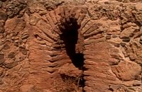 Sitia south at 33.9km (SE) In Makry Gialos, at the place Katovigli, near the church of the Dormition of the Virgin, have been unearthed remains of a Roman Villa. Pendlebury (BSA XXXIII p. 100) had already noted the existence of a Roman settlement here. Excavations begun in 1977 (not yet completed), have shown that there were indeed large domestic establishments, dated from the 1st century BC to the 3rd century AD, but it is not possible at this stage of the excavations to draw definite conclusions. One room after another has been discovered and the whole excavation so far, covers an area of roughly 1500 sq.m. 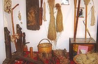 Sitia town at 35.3km (E) The Folklore Museum of Sitia (Siteia, GR: Σητεία) displays items from the 19th and early 20th centuries. It includes some unique embroidery, examples of traditional weaving, wood carvings, local dress and household items, all displayed in an authentic Sitian house setting. Address : 28, Kapetan Sifi Str., 72300 Sitia 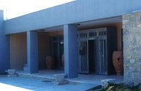 Sitia town at 35.4km (E) Rich displays cover the periods 3500 B.C to 500 A.D. The oldest artifacts come from the wider region of Sitia. The museum is divided into five chronological parts and displays include a valuable collection of vases, clay tablets in Linear A script which were found in the archives at Zakros, figurines from peak sanctuaries, a wine press from the neo-palatial period and a Hellenistic wheat mill. Of special interest is the ivory and gold male figurine which was found in Roussolakkos near Palekastro.
 South east Iraklion at 36.7km (SW) Historical place with outstanding natural beauty, unspoiled villages and great beaches. The town of Ano Viannos is built amphitheatrically on the southern slopes of Dikti mountain at 560 m. above sea in a distance of 65km from Iraklion and 40km from Ierapetra. It preserves the traditional character with the narrow paved streets, the stone built houses - especially the "Plaka' quarter - the old kefeneios with tables under the plane trees and old churches such as Agios Georgios and Agia Pelagia with wall paintings dating back to the 14th century. There are a few accommodation facilities, banks, medical center, taverns, gas stations, shops etc. Ano Viannos is the seat of the municipality of Viannos.
 Voritsi, Gouves at 37.7km (W) Kyra Eleoússa (GR: Κυρά Ελεούσα) Monastery is located close to the village Voroú or Voritsi. Due to its historical value the monastery and the outside area which covers 1000m has acquired protected status. Kyra Eleoussa is built according to feudal architectural style, and despite some interventions over the years it maintains many original architectural features. It is first referred in a document dating from 1606. At first it belonged to the monastery of Agia Ekaterini of Sinai but later it became part of Agarathos monastery.  Skotino,Gouves, Iraklion at 38.7km (W) This is one of the three largest caves in the prefecture of Heraklion. It lies at half an hour distance to the north-west from the village of Skotino and is at a height of 225 m. above sea-level. The entrance to the cave is impressive: a large arch, 27 m wide and 10 m high. To the right one can see the ruins of an ancient chapel on which the modern chapel dedicated to Aghia Paraskevi was built. There is a feast held in front of the chapel on July 26th .
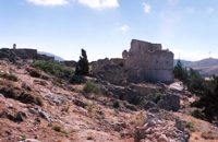 Sitia, East Lassithi at 40km (SE) The settlement of Voila (GR: Βόϊλα) is 1km away from the village of Handras. It is a medieval deserted village protected by the Greek Archaeological Authorities. Passing through the village's alleys you can still see the ruins of old houses and their rooms, their venetian features and through this sacred silence of the place you have the impression that you hear the Byzantine king, the medieval knight or the Turk fighter gallop away. The name of the village probably comes from the Byzantine word VOILAS or VOLIAS meaning the nobleman, the land owner. In a census carried out by Kastrofilaka in 1583, the village of Voila had a population of 301. Many elements show that the village belonged to the venetian family of Zenos which during the Turkish occupation adopted the Ottoman religion and was renamed.The tradition says that he was the owner of a Castle in Voila which has an external inscription with the date 1153 equal to 1742 of the Christian diary. At the south of the castle there is a ruined church known as the church of Ginali. Other attraction at the area is the old painted church of St. George dated back to the 15th century. From the inscription it is obvious that there is a family tomb of Salamons. The Solomons of the island of Zakynthos where our national poet Dionisios Solomos comes from, are believed to having been descended from the Salamons of Sitia. At the top of the hill overlooking the village there is a fortress dated back to the Venetian occupation of the island of Crete. Image Library
 Sitia, East Lassithi at 40.3km (SE) The Monastery of Kapsa is located 40 km from the town of Sitia at the exit of the Pervolakia Gorge built against the steep rocks overlooking the Libyan sea. The exact time of the foundation of the monastery is still unknown, while some believe that it was in the 15th century. Until 1841 there were only a small chapel dedicated to the Saint John the Baptist and a few cells. Image Library
 Gournes at 40.6km (W) The CretAquarium - Thalassocosmos (GR: Θαλασσόκοσμος) was officially opened in December 2005. It provides its visitors with a special experience, a trip to the underwater world of the Mediterranean Sea and its creatures. It is a unique park whose focus is on science, education, culture and recreation and whose goal is to promote, share and spread knowledge concerning the marine environment. Image Library
 Iraklion at 43km (W) The monastery of Agaráthou (GR: Μονή Αγκαράθου), dedicated to the Virgin, stands at an altitude of 538m, on "Soros Panteli", a rocky hill between the villages of Sgourokefali and Sabas, 23 km from Heraklion. During the period of Venetian rule it was a centre of learning, producing many famous churchmen including the Patriarchs Cyril Lucaris, Meletius Pegas and Sylvester the Cretan. The church was rebuilt in 1894 and flourished once more after the end of the Turkish occupation. Young, educated monks with university degrees have recently settled in the monastery, restoring it to its former glory.  Ierapetra at 43.3km (S) A picturesque uninhabited small island of cedar forest, tempting golden beaches and the well preserved old church of Agios Nikolaos, only 8 miles off the port of Ierapetra, to the south. From the middle of May to the end of October, there are daily boat cruises to Chrissi island, departing from Ierapetra and Makrygialos. There is a bar restaurant at the south beach and a beach bar at the northern beach also known as "Golden Beach". The island belongs to the NATURA network due to its rare combination of ecosystems which form the habitats of several endemic species.
Image Library
 Nirou Chani, North - East Iraklion at 43.3km (W) A Luxurious, two-storey house, built of large ashlar. The walls were strengthened by timber-frames and covered with a thick layer of plaster and marble slabs. The building has a paved courtyard, a shrine, storerooms for agricultural products, a staircase, and rooms with benches. It has been interpreted as a High Priest's house, due to the numerous ceremonial vessels it contained. The house was probably built in the 16th century. C. (MM III period) and, after its destruction by fire in the 15th century BC (LM IB period), was finally abandoned. The "Minoan Megaron" at Nirou was excavated in 1918 by St. Xanthoudides. In 1960, under the supervision of the Ephor of Antiquities N. Platon, the site was fenced and the building restored. The monument is consolidated and cleared at intervals by the 23rd Ephorate. Visiting Hours: Daily: 8:30-15:00, Monday: closed Entrance Fee:Free Admission 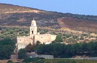 Sitia at 45.1km (E) It is an historical monastery of the 15th century, which collapsed in the earthquake of 1612 and was rebuilt with the financial aid of the Venetians. During the Ottoman conquest of Crete, the monastery was destroyed and devastated by the Turks. In 1704 the monastery was declared stauropegion. During the Ottoman occupation there was a school in the monastery, while, after 1870, it was founded there a school of mutual teaching. The Monastery is a stauropegion fortress. The main building of 800 m2 has three floors, which are divided into cells, guest - houses, kitchens, the abbot' s residence and warehouses. The katholicon is a two-aisled church; the northern aisle is dedicated to the Virgin, and the southern posterior aisle, to St John the Theologian. The monastery' s characteristic bell tower bears relief crowns and crosses with inscriptions and the date 1558. In the Monastery, there is also an interesting Museum.
Image Library
 Myrtia. Iraklion at 46.6km (W) The Nikos Kazantzakis Museum is dedicated to the great Greek writer, poet and philosopher Nikos Kazantzakis. It was founded in 1983 and it is located at the village Myrtia in Iraklion, next to his father's house. The museum contains some of his personal belongings (pipes, glasses, pens, etc.) and a rich collection of his manuscripts and letters, first Greek editions of his books, documents from theatrical productions of his works, copies of TV series and movies based on his novels, portraits of Nikos Kazantzakis, copies of press releases and articles on his life and work. 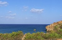 Sitia, East Lassithi at 49km (E) A palm tree forest stretching on a marvelous valley and sandy beach. It consists of self planted palm trees of Theophrastus (Phoenix Theophrasti). It is unique of its kind in Greece, Europe and probably the world. Vai because of its special value and beauty is protected by the Greek state, European Union and international contracts. The protected area covers 23.4 ha. The sandy beach of Vai is amongst the most beautiful in Crete and Greece and attracts thousands of visitors every year since Vai is a top destinations especially for the new comers. The small islets opposite the beach add a lot to the beauty of the place. There is a parking area, a tavern, a canteen, umbrellas and seabeds. There is regular public bus connection with the towns of Sitia and Palaikastro during the summer and many organised day trips by travel agencies. If you don't like crowds, you can walk a little to the south from Vai to Psili Ammos a lovely small beach with fine gold sand which is nested in a small cove. Image Library
|
||
|
| ||


C
O
N
T
E
N
T
S
O
N
T
E
N
T
S