interkriti®
YOUR GATEWAY TO CRETE
HOME
CRETE FACTS
NAVIGATE
EXPLORE

Agia Galini
Triopetra
Kissamos
Chryssi Isl.
Agia Marina
Balos
Gavdos isl.
Georgioupolis
SAMARIA
IDA Mtn
Palaiochora
Agia Roumeli
Sfakaki
Bali
Kalamaki
Matala
Lassithi
Plateau Lendas
Tsoutsouros
Vianos
Myrtos
Sfakia
Plakias
Ierapetra
Makrygialos
ZAKROS
Vai
Sitia
Agios Nikolaos
Elounda
MALIA
Hersonissos
Gouves
Chania
Rethymnon
Heraklion
GORTYN
FESTOS
KNOSSOS
|
|
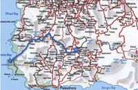
Crete
List Grid Map
Found
94
- Showing :
41 - 60
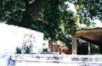
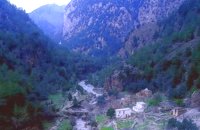 Samaria National Park at 25.5km (S) The deserted village of Samariá (GR: Σαμαριά) is located in the middle of the gorge of Samaria, 7.5 km away from Xyloskalo and 8.5km fro Agia Roumeli. This is the main resting point for the gorge walkers coming down from Omalos. There is a fountain with fresh drinkable water from the spring, benches and some tables, in the shade of tall plane trees where the visitors can relax and have some food (Only if they carry it with them). The village of Samaria was abandoned in 1962, when the area declared a National Park. The main occupations of its inhabitants were the wood cutting and bee keeping. Opposite the village are the old olive trees cultivated mainly for the residents' own consumption. Some of the village' s ruined housed are restored and are used today by the gorge authorities. One houses the guards' post, another the doctor's office and a third - the old olive mill - houses the information kiosk of the park where the visitors can view old pictures and folk art exhibits. Kri - kris (the Cetan Ibex) make their appearance here from time to time especially the young ones which are less shy. At the village's edge lies the byzantine church of "Osia Maria of Egypt" (Osia = Saint). The name Samaria is believed that is a corruption of the words "Osia Maria" or "Santa Maria". A little before the village (coming from Xyloskalo) in a small clearing lies the small church of Agios Geórgios. Image Library
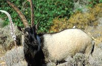 Cretan Ibex, Lefka Ori, Hania at 25.6km (S) Kri-Kri is the common name of the Cretan feral goat (Capra aegagrus ssp. cretica) which is the largest wild mammal on the island. Its grandeur, its bravery, its ability to observe without being noticed, its speed and its impressive horns are the features that were loved by the locals and made it a symbol of Crete and the untamed Cretan spirit. It lives mainly on the White Mountains and its local name is "Agrimi" (GR: Αγρίμι = the wild one) for the male and "Sanada" (GR: Σανάδα) for the female. Recent years, young kri-kris have approached the old village of Samaria, where they are fed by the park rangers and can be seen by the visitors. Kri-kris and goats are close genetically, as the hybridization that exists between them show. Kri-kri's size however is a good deal larger than that of a goat Kri-kris have a strong sexual dimorphism. Males are larger than females. They all have horns, with annual rings and knobs, from which their age can be easily calculated. Males have larger horns than females (up to 90 cm), which curve backwards. An other characteristic of the males is the beard, which rarely occurs in females. Their coat is short and brown in summer and brownish and denser in winter. They have a black line on the back, which extends from the neck to the top of the tail while at its shoulders the line intersects with another one that reaches the stomach. There are also black patterns on the front parts of their legs. There are numerous representations of Kri-kris on ancient sealstones, vases and coins, indicating the esteem in which they were held by the people of antiquity. Phototograph by Anastassios Sakoulis - www.photophysis.gr Image Library
 Apokoronas at 25.6km (E) A beautiful small sea side village with long sandy beach where wind surf, canoes, paddle boats, umbrellas and sun beds can be rented. The place provides all the facilities for the visitors with small hotels, rooms, apartments and many taverns with traditional food and fresh fish. Recent years it became very popular with expatriates and there is a significant development in the real estate sector.
Image Library
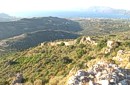 archaeological site in Kissamos at 25.9km (W) Polyrinia (GR: Πολυρρήνια) was one of the most important cities-states of the Western Crete.It was built amphitheatrically on top of the hill (418 m altitude) with a commanding view of both the Cretan and the Libyan sea, located 49 km from Hania and 6 km from Kissamos . The history of Polyrinia starts in the Minoan period and continues to the present day.
 Kissamos at 26.4km (W) The village of Polyrinia is built on the foot of the hill that ancient Polyrinia used to be. It is a small village located 6.5km away from Kastelli Kissamou, built at an altitude of 300 m. and has approximately 100 permanent residents. Its old name was Apano Paleokastro and was renamed to Polyrinia due to its proximity to the archaeological site. Important sights are: the aqueduct of Andrianos, the temple of the Assumption of the Holly-Mother and an old olive mill.
 Apokoronas, Hania at 26.4km (E) Pláka (GR: Πλάκα) is a lovely village in the Apokoronas area, less than one kilometer away from Almyrida, with interesting architectural style, which is unfortunately changing due to intense building mainly for tourist purposes. Its ~300 permanent inhabitants, occupying mostly with farming, stock-breeding, fishing and lately with tourism. It has all the basic amenities, including excellent tavernas, bars, a grocery store and a kafeneion. Plaka is built on the slope of a hill at 70 m above sea, with a panoramic view of the bay of Souda. The surrounding environment has maintained its character well and is ideal for walks either inland or along the coast. Visitors can also admire a magical sunset from here. Every summer -at about the end of July- a two days traditional feast - The Plakiana - is organized to honour the memory of the great local lyra player Mihalis Papadakis or else Plakianos. During the feast guests enjoy Cretan dances and can visit the textile and ceramics exhibitions. The custom of Klidonas is celebrated at the end of June and the Carnival usually takes place in March.  Apokoronas, Hania at 27.4km (SE) Vámos (GR: Βάμος) is the capital of Apokoronas district is an exceptionally interesting village that the Ministry for the Environment, Physical Planning and Public Works has classed as traditional. It is more like a small town, very well preserved, with folk and neoclassical architectural elements. The initiative of a group of inhabitants to create an association for the preservation of the village as well as alternative tourism strategies is already paying off while constituting a model for further local progress. The famous art and cultural festivals are good opportunities for everyone to experience the hospitality and entertainment Vamos can offer.
 Gavalohori, Vamos, Apokoronas at 27.4km (SE) The exhibition of the objects takes place according to the contemporary museum conception, with explanatory texts, photographs, plans, models, and is enriched with new exhibits every year. The Museum is divided into seven rooms, according to the following units: The Arched House, Silk, Pottery, Lace-making, Masonry and Stone carving, Church and Woodcarving.
 Apokoronas, Hania at 27.4km (SE) Gavalohóri (GR: Γαβαλοχώρι) is an old big traditional village, with fine examples of traditional rural architecture and stone buildings that are well preserved. The village has been declared a traditional settlement and is awarded a protected status. Many interesting buildings still stand, such as the 18th century olive press, the church of Panagia (Virgin Mary) and that of Agios Sergios, the old school and the complex of the wells from the period of the Venetian occupation.
 by Richard Ellis at 27.5km (SW) 2nd September - I was up and away from Kandanos by 0650 with the intention of meeting Susa at Elos, spending the night there and dropping down to the west coast next morning. However, it is good to be flexible. The verges of the road to Elos were full of "mellow fruitfulness" - I enjoyed handfuls of blackberries and a couple of the sweetest figs I have ever tasted. The sweet chestnuts were looking good for later, but as all over Crete the grapes had been badly spoiled by a very cold wet Spring. Distance: 32.3 km Time: 7 hrs. Mov av 5.3 km/hr Height: Sea level.  Apokoronas, Hania at 27.6km (E) Kókino Horio (GR: Κόκκινο Χωρίο), which is located at a higher altitude, has maintained its traditional architectural style even more so than the other villages with its narrow roads, beautiful gates and tiled roofs. A group of cisterns, built in a sloping field, gather the rainwater, an interesting example of local architecture, dealing with the permanent problem of lack of water. Above Kokino Horio one can see the strangely shaped hill Drapanokefala or Calapodha (so named during the venetian occupation). The coastline northwest of the village is an extremely interesting place for a stroll due to the ground formation and the caves, such as the cave of Petsi (or Karavotopos). Another cave called Katalimata, located at the centre of the village, is also an interesting site. At cape Drapano, approximately 10 metres under water, is the impressive Elephant cave, an area 60mx60m full of stalactites and stalagmites of various shapes and colours. Video - The Elephants' Cave  Selino, Hania at 28.6km (SW) Elyros ("Έλυρος" in Greek) is an ancient city, located in southwest Crete, in Kefala Hill, near the village Rodovani and is presently unexcavated. Elyros was flourishing at least as early as the Greek Classical Period, e.g. 500 to 350 BC. In the Classical Period Elyros was the most important ancient city in southwestern Crete, having about 16,000 inhabitants. It was an industrial and commercial city with large weapons production. Syia and Lissos were its harbours. Apollo, Phylakides and Philandros, sons of Apollo and nymph Akakallida, were worshiped there. In the third century BC Elyros was at war with Kydonia, an important center of Cretan power, located in the modern city of Chania. The citizens of Elyros sent to the Delphi Oracle, a bronze votive complex that represents a goat feeding the sons of Apollo when they were infants. It is also one of the thirty cities that signed the decree with Eumenes B’ in 183 BC.Elyros was also important during Roman times. A Roman statue, the Philosopher of Elyros was recovered here and is now in the Archaeological Museum of Chania. During Byzantine times, Elyros was the seat of an Archbishop and the remains of the bishopric church, a sixth century basilica, can still be seen in the centre of the old city. Robert Pashley was the first who identified the location of the city, near village Rodovani. Thenon studied more carefully the ruins of the city and discovered the inscription that says: “it seemed to the city of the Elyrians”. The output of its mint consists of silver drachms from the 3rd c. BC, which depict a wild goat and a bee; in addition to their function as religious symbols, these undoubtedly hint at the stock-raising activities in the region, particularly to this kind of wild goat, which can still be found in great numbers on the island. The bee also has reference to the abundant honey-production of Crete. 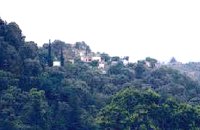 Kissamos at 28.6km (SW) Sirikari (GR Σηρικάρι) is a small village located 52 km away from Hania and 14 km from Kastelli at 500m a.s.l. The name Sirikari probably comes from the profession of the first settler, who has to be a silk weaver (Sirikaris). A short ravine starts from Sirikari and ends close to Polyrinia. There is also a chestnut tree forest, the cave of the Holy Mother (Panagias), the byzantine church of Agii Apostoli, with frescoes of 14th century a monument of great importance and two old factories.  Apokoronas, Hania at 29.2km (SE) The traditional little village of Vrisses lies approx. 35 km from Chania town. The old village square with its tall plane trees, the tavernas and kafenions is the perfect place to relax and enjoy the lush green landscape by the river Vrissanos and taste the renowned and particularly delicious local yogurt.
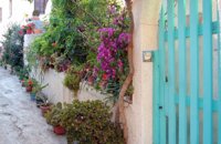 Kissamos at 29.2km (W) The beautiful village of Kaliviani (GR: Καλυβιανή) is located in the beginning of the peninsula of Gramvoussa. The beauty of the village can be attributed to its wonderful stone houses and to the many flowers that blossom in every yard. Its people are friendly and hospitable. The tradition is alive in Kaliviani, since even today the houses are built the traditional way, with stones, by skillful technicians. 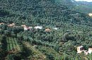 Kissamos, Hania at 29.4km (SW) Vlatos is located at 380m a.s.l., 54 km away from Hania and 18 km from Kastelli Kissamou. It is built in a tree covered valley, with olive trees, chestnut trees and wild vegetation. There are some very nice trekking paths around and in the forest of "Peace" which has been characterized as a natural park. The "Park of Peace" was founded in 1970 by the Cultural Association of Vlatos with the cooparation of Goethe Institute and the support of the Bavarian Department of Forests. It is an experimental park with 150 species of plants, covers an area of 1,000,000 sq.m. and is part of an extended area of 20 sq.km. which have been reforested.  Samaria National Park at 29.6km (S) Pórtes (GR: Πόρτες - Gates) or Sideróportes (Iron Gates) is maybe the most striking point of the canyon. Here the canyon walls rise nearly 300 meters while the width is only 3.5 m. At this point the water runs almost all year round. The stratified limestone, the dominant rock of the canyon, forms specific geological formations, showing all the geological history of the canyon in the eyes of connoisseurs. Portes are 11 km away from the entrance of the Samarian gorge at Xylóskalo and 4km from the beach at Agia Roumeli.
Image Library
 Kissamos west coast at 30.5km (W) Platanos (GR: Πλάτανος = plane-tree) is located 10 km from Kasteli Kissamos. It is a large village, the second largest in Kissamos area, after Kasteli. It has approximately 1000 inhabidants, which are occupied mainly in green house and olive cultivation and tourism. There is a doctor's office, gas stations, many shops, rooms for rent and taverns. At the village's old square stand a plane-tree with a fountain.  Apokoronas, Hania at 30.8km (SE) The community of Kefalas (GR:Κεφαλάς) is situated in Apokoronas, Hania, approximately 4 km to the east of Vamos. During the Venetian occupation higher and lower Kefalas were classed as two separate villages, however, today they have become one. It is a large village built in an outstanding position facing the sea with architecture dominated by the influence of the early and late years of the Turkish occupation. This influence is well preserved despite the existence of other architectural styles. The church of Timios Stavros (16th century) is the oldest building of the village while the more recent churches of Panagia, Agios Antonios, and Michael the archangel, works of the reputed Kefalas craftsmen, are examples of folk architecture of the 19th century. A further example of the work of the same craftsmen is the Public School of Kefalas, which in accordance with the decision of the county council of Hania will house the Environmental Educational Centre of the prefecture, a foundation that will play a definitive role in the development of the municipality of Vamos. Other interesting communities are Paleloni and Drapanos in the direction of Kokino Horio. The road from Paleloni leads to Embrosgialo, a relatively easily accessible place, along the steep coastline, which extends to Georgioupoli.  Coastal town in Selino, South Hania at 31.8km (S) The village of Souyia or Soúgia (GR:Σούγια) is located 75 km southwest of Hania at the southern coast of Crete a little to the east of Paliohora. Sougia is becoming very popular vacation place especially with nature lovers and walkers. There are some ancient sites around and Sougia itself was the port of the ancient town 'Elyros'. There are also quite a few accommodation properties and taverns, a great beach and a small port .
Image Library
|
||
|
| ||


;)
;)
;)
;)
;)
;)
C
O
N
T
E
N
T
S
O
N
T
E
N
T
S