interkriti®
YOUR GATEWAY TO CRETE
HOME
CRETE FACTS
NAVIGATE
EXPLORE

Agia Galini
Triopetra
Kissamos
Chryssi Isl.
Agia Marina
Balos
Gavdos isl.
Georgioupolis
SAMARIA
IDA Mtn
Palaiochora
Agia Roumeli
Sfakaki
Bali
Kalamaki
Matala
Lassithi
Plateau Lendas
Tsoutsouros
Vianos
Myrtos
Sfakia
Plakias
Ierapetra
Makrygialos
ZAKROS
Vai
Sitia
Agios Nikolaos
Elounda
MALIA
Hersonissos
Gouves
Chania
Rethymnon
Heraklion
GORTYN
FESTOS
KNOSSOS
|
|
Crete
List Grid Map
Found
119
- Showing :
41 - 60
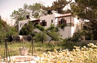 Paleohora at 29.1km (W) Villa Anna is located 100 m. from beach. Villa Anna consists of two separate buildings (each comprising four apartments), surrounded by a rich garden of 2000 sq. m. The apartments are all fully equipped with appliances and comforts: kitchen (complete with fridge/freezer, oven/cook, pots/pans and cutlery), bathroom, living room with TV, A/C and one or two bedrooms. Ideal for comfortable vacations and relax.
 Gavalohori, Vamos, Apokoronas at 29.4km (NE) The exhibition of the objects takes place according to the contemporary museum conception, with explanatory texts, photographs, plans, models, and is enriched with new exhibits every year. The Museum is divided into seven rooms, according to the following units: The Arched House, Silk, Pottery, Lace-making, Masonry and Stone carving, Church and Woodcarving.
 Apokoronas, Hania at 29.5km (NE) Gavalohóri (GR: Γαβαλοχώρι) is an old big traditional village, with fine examples of traditional rural architecture and stone buildings that are well preserved. The village has been declared a traditional settlement and is awarded a protected status. Many interesting buildings still stand, such as the 18th century olive press, the church of Panagia (Virgin Mary) and that of Agios Sergios, the old school and the complex of the wells from the period of the Venetian occupation.
 Aptera, Apokoronas, Hania at 29.6km (NE) One of the most important city - states of Crete. The first epigraphic occurence of its name (A-pa-ta-wa) is found in the Linear B tablets found at Knossos. (14th - 13th century B.C.). The history of the city is continued through the centuries untill the 7th century A.D. when a major earthquake destoyed it. Its ideal location, allowed the city to control the naval activity in the bay of Souda, and was determinative for its development in an important commercial center. The era of the city's greatest peak was the early Hellenistic period (late 4th - 3rd century B.C.). At that time Aptera experienced an economical and political floruit, begins to mint its own coins and develops diplomatic relations with important centres of the Hellenistic world.
The most important monuments of the site are: Roman cisterns. Bipartite temple, known as the "bipartite sanctuary", dated to the 5th-4th century B.C. Graves of the Geometric-Roman periods. The fortification wall, preserved to a length of almost 4 kilometres. Part of a Roman bouleuterion. Byzantine buildings. Monastery of Agios Ioannis Theologos. Turkish fortress built in 1866-1869. Source: The Hellenic Ministry of Culture  Apokoronas at 30km (NE) A flourishing traditional seaside town on the Apokoronas Peninsula 17km east of Hania. Kalýves (or Kalives GR: Καλύβες) with its old tiled stone houses, mixed with the latest buildings form two separate districts, with typical island style. Most of it is literally built on the sea and has 1289 residents. Xydás (GR: Ξυδάς) river that runs through the town, is giving it a unique character and a cool climate that prevents the heat of summer. In the square, you will see a traditional water mill built in the early 20th century, one of the oldest in the area. Kalives is tastefully developed for tourism, and welcomes many visitors during the summer season to its safe sandy beach. With comprehensive amenities, there are many shops, taverns and kafeneion, in addition to banking, post office and petrol station facilities.
 Aptera, Apokoronas, Hania at 30.1km (NE) Those are two Turkish castles that are built in the 19th century using material from the nearby archaeological site of Aptera. The lower castle is that of Itzedin (also known as Kalami fort) named in honour of the son of the Sultan of the time, by the commander of Crete, Reouf Pasha was used in the past as a prison.
 article by Stelios Asmargianakis at 30.3km (NE) An article where Stelios Asmargianakis describes his experience of sea kayak, through a two-day trip to the north of Chania as it took place in mid February 2012. The whole journey is about 40 km, and is characterized by the absence of beaches for easy approaching and relaxing as well as exposure to the elements of the Cretan Sea.
 Apokoronas, Hania at 30.4km (NE) The community of Kefalas (GR:Κεφαλάς) is situated in Apokoronas, Hania, approximately 4 km to the east of Vamos. During the Venetian occupation higher and lower Kefalas were classed as two separate villages, however, today they have become one. It is a large village built in an outstanding position facing the sea with architecture dominated by the influence of the early and late years of the Turkish occupation. This influence is well preserved despite the existence of other architectural styles. The church of Timios Stavros (16th century) is the oldest building of the village while the more recent churches of Panagia, Agios Antonios, and Michael the archangel, works of the reputed Kefalas craftsmen, are examples of folk architecture of the 19th century. A further example of the work of the same craftsmen is the Public School of Kefalas, which in accordance with the decision of the county council of Hania will house the Environmental Educational Centre of the prefecture, a foundation that will play a definitive role in the development of the municipality of Vamos. Other interesting communities are Paleloni and Drapanos in the direction of Kokino Horio. The road from Paleloni leads to Embrosgialo, a relatively easily accessible place, along the steep coastline, which extends to Georgioupoli. 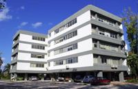 Hania at 30.4km (N) The Institute for Olive Tree and Subtropical Plants of Chania is one of the Institutes of the National Agricultural Research Foundation (NAGREF), located at Chania, Crete, Greece. The Institute consists of 10 Laboratories, with research activities focused on the following fields: Oliviculture and Post-harvest Physiology, Citriculture, Subtropical Plants, Irrigation and Water Resources Management, Plant Mineral Nutrition and Physiology, Entomology, Plant Pathology, Food Technology, Hydroponic Culture and Aromatic Plants, and Animal Production. The research activities of the Institute are supported by modern facilities, including fully equipped laboratories, glasshouses, 50 ha of experimental fields and collections of genetic material for olive, citrus, subtropical plants and grapevines.  Hania at 30.5km (N) Institute dedicated to postgraduate and specialised education, applied research and the development of Mediterranean agriculture. MAICh offers postgraduate programs in the following fields: Business Economics and Management, Geoinformation in Environmental Management, Horticultural Genetics and Biotechnology, Food Quality and Chemistry of Natural Products and Sustainable Agriculture.  Apokoronas at 31km (NE) A beautiful small sea side village with long sandy beach where wind surf, canoes, paddle boats, umbrellas and sun beds can be rented. The place provides all the facilities for the visitors with small hotels, rooms, apartments and many taverns with traditional food and fresh fish. Recent years it became very popular with expatriates and there is a significant development in the real estate sector.
Image Library
 Rethymnon North at 31.1km (E) A beautiful small town in the county of Rethymno with great views, natural water springs and lush vegetation. It's located at 260m a.s.l. between the rivers "Mousselas" and "Petres", 22km from the national road and 5km from Episkopi. Argiroupolis is the site of the ancient city of Lapa.
 by Richard Ellis at 31.1km (E) 28th August - Because we had researched this bit in May, it wasn't so daunting to leave the tarmac-bound E4 and to launch off uphill to make the old crossing (not yet on any map) between here and Askyfou. The first gully climb up to 3,300 ft was quite straight forward as we had done it before. Distance: 22.4 km Time: 8 hrs. 35mins. Mov av 3.7 km/hr Height overnight: 714m.  Apokoronas, Hania at 31.8km (NE) Pláka (GR: Πλάκα) is a lovely village in the Apokoronas area, less than one kilometer away from Almyrida, with interesting architectural style, which is unfortunately changing due to intense building mainly for tourist purposes. Its ~300 permanent inhabitants, occupying mostly with farming, stock-breeding, fishing and lately with tourism. It has all the basic amenities, including excellent tavernas, bars, a grocery store and a kafeneion. Plaka is built on the slope of a hill at 70 m above sea, with a panoramic view of the bay of Souda. The surrounding environment has maintained its character well and is ideal for walks either inland or along the coast. Visitors can also admire a magical sunset from here. Every summer -at about the end of July- a two days traditional feast - The Plakiana - is organized to honour the memory of the great local lyra player Mihalis Papadakis or else Plakianos. During the feast guests enjoy Cretan dances and can visit the textile and ceramics exhibitions. The custom of Klidonas is celebrated at the end of June and the Carnival usually takes place in March.  North West Crete at 32.4km (N) Hania (or Chania GR: Χανιά) is the capital of the Prefecture of the same name and the second biggest town in Crete, with a population of 60.000 inhabitants. It lies (Coordinates 35°31' N 24°1' E ) along the North coast of the island, about 55 km west of Rethymnon and 140 km west of Iraklion (Heraklion). Hania's old town (although it was heavily bombed by Germans in World War II) is considered as Crete's most beautiful urban district, especially the Venetian harbour with its 16th century lighthouse and the Mosque of the Janissaries ("Giali Tzamissi", built 17th century). Many of the old buildings have been restored as hotels, restaurants, shops and bars, making the old town a lively and colourful place, especially during the tourist period.
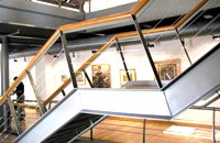 Hania old town at 32.4km (N) An institution of culture, that aims in the creation of necessary "space", where the various sectors of Art, Science and Literature can coexist, each seeking the contribution of the other, thus becoming feasible the materialization of visions that each one of these means of expression of the Human spirit, to be able offer to the community. Address: 98-102, Chalidon Street, 73 131 Chania, Crete, Greece Phone number: +30 28210 92294 / +30 28210 36190 E-Mail: info@pinakothiki-chania.gr Links: Dimodiki Pinakothiki Hanion 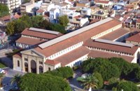 Hania town at 32.5km (N) The Market, impressive for its size and shape, is built in the shape of a cross with 76 shops grouped according to their wares in the four arms of the cross. The south façade is particularly well constructed out of chiseled limestone, in the architectural style of the local tradition, developed during the Venetian period. Its construction was completed in 1913 and the formal opening was made by Eleftherios Venizelos on 4th December 1913 as part of the celebrations for the Unification of Crete to Greece.
 Rethymnon North at 32.6km (E) Episkopi is a small town of the prefecture and county of Rethymno. It is located at the old national road of Rethymno - Hania, 17 km away from the city of Rethymno. The town is built at 120 m a.s.l. overlooking the northern coast of Crete, and the green and fertile valley of Mousselas river.
 Apokoronas, Hania at 32.7km (NE) Kókino Horio (GR: Κόκκινο Χωρίο), which is located at a higher altitude, has maintained its traditional architectural style even more so than the other villages with its narrow roads, beautiful gates and tiled roofs. A group of cisterns, built in a sloping field, gather the rainwater, an interesting example of local architecture, dealing with the permanent problem of lack of water. Above Kokino Horio one can see the strangely shaped hill Drapanokefala or Calapodha (so named during the venetian occupation). The coastline northwest of the village is an extremely interesting place for a stroll due to the ground formation and the caves, such as the cave of Petsi (or Karavotopos). Another cave called Katalimata, located at the centre of the village, is also an interesting site. At cape Drapano, approximately 10 metres under water, is the impressive Elephant cave, an area 60mx60m full of stalactites and stalagmites of various shapes and colours. Video - The Elephants' Cave 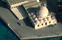 Venetian port, Chania at 32.8km (N) The temple Kioutsouk (small) Hassan or Giali Tzamisi (seaside mosque), as it was commonly called, a brilliant sample of Islamic art of the Renaissance was a work of an Armenian architect, who had constructed another similar mosque in 'Spaniako', a village in the county of 'Selino'. The mosque, in the yard of which there were palm trees and graves of pashas and janissaries, stopped operating in 1923 and today it is restored without the small and picturesque minaret demolished in 1920.
|
|||
|
| |||


;)
;)
;)
;)
;)
;)
C
O
N
T
E
N
T
S
O
N
T
E
N
T
S