interkriti®
YOUR GATEWAY TO CRETE
HOME
CRETE FACTS
NAVIGATE
EXPLORE

Agia Galini
Triopetra
Kissamos
Chryssi Isl.
Agia Marina
Balos
Gavdos isl.
Georgioupolis
SAMARIA
IDA Mtn
Palaiochora
Agia Roumeli
Sfakaki
Bali
Kalamaki
Matala
Lassithi
Plateau Lendas
Tsoutsouros
Vianos
Myrtos
Sfakia
Plakias
Ierapetra
Makrygialos
ZAKROS
Vai
Sitia
Agios Nikolaos
Elounda
MALIA
Hersonissos
Gouves
Chania
Rethymnon
Heraklion
GORTYN
FESTOS
KNOSSOS
|
|
Crete
List Grid Map
Found
62
- Showing :
41 - 60
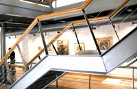 Hania old town at 38.1km (E) An institution of culture, that aims in the creation of necessary "space", where the various sectors of Art, Science and Literature can coexist, each seeking the contribution of the other, thus becoming feasible the materialization of visions that each one of these means of expression of the Human spirit, to be able offer to the community. Address: 98-102, Chalidon Street, 73 131 Chania, Crete, Greece Phone number: +30 28210 92294 / +30 28210 36190 E-Mail: info@pinakothiki-chania.gr Links: Dimodiki Pinakothiki Hanion 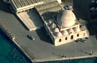 Venetian port, Chania at 38.2km (E) The temple Kioutsouk (small) Hassan or Giali Tzamisi (seaside mosque), as it was commonly called, a brilliant sample of Islamic art of the Renaissance was a work of an Armenian architect, who had constructed another similar mosque in 'Spaniako', a village in the county of 'Selino'. The mosque, in the yard of which there were palm trees and graves of pashas and janissaries, stopped operating in 1923 and today it is restored without the small and picturesque minaret demolished in 1920.
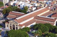 Hania town at 38.4km (E) The Market, impressive for its size and shape, is built in the shape of a cross with 76 shops grouped according to their wares in the four arms of the cross. The south façade is particularly well constructed out of chiseled limestone, in the architectural style of the local tradition, developed during the Venetian period. Its construction was completed in 1913 and the formal opening was made by Eleftherios Venizelos on 4th December 1913 as part of the celebrations for the Unification of Crete to Greece.
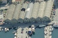 Hania, old port at 38.5km (E) The south complex was completed in 1599, with the construction of 17 Neoria. Today only 7 survive out of the 17. In their original form they were open on the side of the sea. The ceilings are arched, and they are connected with arched openings of the same thickness as the walls.
 Chalepa, Hania at 39.9km (E) The Archaeological Museum of Chania is located in the historic suburb of Chalepa, on a plot of land covering 11,526.81 m2, with a total area of approximately 6,000 m2. Its location, averaging 98 m above sea level, offers a magnificent view over much of the city, especially the seafront. The Museum, designed by architect Theofanis Bobotis and partners, is composed of two distinct linear monolithic masses rising from the earth, a symbolic reference to the vestiges of civilisation beneath the surface. The permanent exhibition of the Archaeological Museum of Chania is set out in three galleries on the ground floor, presenting the archaeological riches of the regional unit of Chania from the first traces of human presence in Chania to the 4th century AD, and a gallery on the upper floor where part of the Konstantinos, Marika and Kyriakos Mitsotakis Collection is exhibited. The exhibition is enriched with faithful reconstructions of various spaces, visual media, digital presentations, tactile exhibits (copies of ancient objects) accompanied by Braille captions, and an audio guide. The Temporary Exhibition Gallery and the Museum gift shop are on the ground floor, while the Educational Programme Room, the Amphitheatre and the Café are on the upper floor. 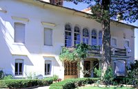 Halepa, Hania at 40km (E) After the scientific and administrative services of the Foundation "Eleftherios Venizelos" were transferred to the former Vloom Mansion, in 2005, the Venizelos residence remained the Foundation's headquarters and it has been converted into a Museum, a commemoration site for Eleftherios Venizelos. The residence bears the imprint of Eleftherios Venizelos and the building has maintained its original form, of the years he lived there. The furniture of the decade 1925-1935 was selected by Venizelos himself and his wife Elena, and was brought from Athens and abroad. Decorative objects and paintings of the period, original photographs and personal items of significant value decorate the interior of the residence. Website:www.venizelos-foundation.gr 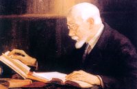 Politician born in Mournies, Chania at 40.1km (E) Eleftherios Venizelos (Elefthérios Kyriákou Venizélos, GR: Ἐλευθέριος Κυριάκου Βενιζέλος - 23 August 1864 – 18 March 1936), born in Mournies village near Chania, was an eminent Greek revolutionary, a prominent and illustrious statesman as well as a charismatic leader in the early 20th century. Elected several times as Prime Minister of Greece and served from 1910 to 1920 and from 1928 to 1932. Venizelos had such profound influence on the internal and external affairs of Greece that he is credited with being "the maker of modern Greece", and he is still widely known as the "Ethnarch".
 Chania at 40.1km (E) The aim of the Foundation is to function on a national level as a dynamic european research and educational centre constituting a central point of reference for the coordination of research into the work, era and life of the great statesman and more generally into modern Greek history without ideological constraints and preconceptions and without local limitations. The address of the Foundation is: National Research Foundation "Eleftherios K. Venizelos" House of Eleftherios Venizelos Elena Venizelou Square, Chalepa, 731 33 Chania T.K. 73133 Tel. (0030) 28210-56008, 51555-6, 54011 Fax (0030) 28210-56009 Email: info@venizelos-foundation.gr Office Hours: 08:30 - 16:00 Website:www.venizelos-foundation.gr  Hania at 40.4km (E) The Institute for Olive Tree and Subtropical Plants of Chania is one of the Institutes of the National Agricultural Research Foundation (NAGREF), located at Chania, Crete, Greece. The Institute consists of 10 Laboratories, with research activities focused on the following fields: Oliviculture and Post-harvest Physiology, Citriculture, Subtropical Plants, Irrigation and Water Resources Management, Plant Mineral Nutrition and Physiology, Entomology, Plant Pathology, Food Technology, Hydroponic Culture and Aromatic Plants, and Animal Production. The research activities of the Institute are supported by modern facilities, including fully equipped laboratories, glasshouses, 50 ha of experimental fields and collections of genetic material for olive, citrus, subtropical plants and grapevines.  Hania at 40.6km (E) Institute dedicated to postgraduate and specialised education, applied research and the development of Mediterranean agriculture. MAICh offers postgraduate programs in the following fields: Business Economics and Management, Geoinformation in Environmental Management, Horticultural Genetics and Biotechnology, Food Quality and Chemistry of Natural Products and Sustainable Agriculture.  Samaria National Park at 41.1km (SE) Pórtes (GR: Πόρτες - Gates) or Sideróportes (Iron Gates) is maybe the most striking point of the canyon. Here the canyon walls rise nearly 300 meters while the width is only 3.5 m. At this point the water runs almost all year round. The stratified limestone, the dominant rock of the canyon, forms specific geological formations, showing all the geological history of the canyon in the eyes of connoisseurs. Portes are 11 km away from the entrance of the Samarian gorge at Xylóskalo and 4km from the beach at Agia Roumeli.
Image Library
 Akrotiri, Chania at 41.7km (E) At the magical and historical location of Profitis Ilias, in Akrotiri, at the east of Hania lays the tomb of Eleftherios Venizelos, one of the most long-standing prime ministers of Greece and whose political life was focused on doubling the size of Greek territory and on the creation of a contemporary State. Eleftherios Venizelos himself had designated this position to be his resting place before his death. For the visitor, it affords a panoramic view of the rich green plain of Hania, the imposing White Mountains, the Cretan Sea, the town of Hania and the Chalepa quarter which is the location of the house in which the great politician spent most of his life and today is the headquarters of the National Research Foundation 'Eleftherios K. Venizelos'. Image Library
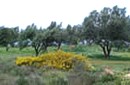 Akrotiri, Hania at 41.9km (E) At a time that living organisms are disappearing at an alarming rate, especially through habitat destruction, the Park for the Preservation of Flora and Fauna of the Technical University of Crete, which extends to 30 hectares, constitutes a small but important area where native plants and co-existing animals are protected and can develop without human intervention. Up to now 250 different plant species that grow naturally in habitats of the Park have been identified, while their systematic documentation is still in progress. The development of new ecological units (“habitats”) began in areas of the Park that have been cultivated in the past. These will include plant species of Crete that do not grow naturally in the Park. Two such units, the wetland and the coastal habitats have already been launched. www.park.tuc.gr/  Sfakia, South Hania at 42.4km (SE) Agia Rouméli (GR: Αγία Ρουμέλη)is a small fishing village, approximately two kms from the ending of Samaria Gorge. It is accessible only by boat from Paleohora, and from Hora Sfakion. It serves mainly as a stopover for visitors coming down the Samaria Gorge, and waiting for the boat to take them to Sfakia or Paleohora. However those who decide to stay for a couple of days or more will find apart from the unique scenery, a great beach with crystal clear water, plenty of interesting walks and a good choice of accommodations, taverns, cafés and stores. The place is also rich in history as it was inhabited since the antiquity. It is the site of the ancient city of Tárra (GR: Τάρρα), a famous cult place, that flourished from the Classical to the Roman times. Image Library
 by Richard Ellis at 42.5km (SE) 31th August - Katsiveli to Kallerghi via Pachnes- The day dawned with a cloudless blue sky. I was lucky. The route starts with a gentle two km warm up across the Niato plateau before turning more vicious. The next phase is a very steep 700 meter climb up the north east ridge of Kastro. One of the pluses is that you are doing this in the relative cool of the morning - one of the minuses is that you will probably be carrying something like five litres of water. Distance Total (with Pachnes climb): 25.3 km Time: 9 hrs. 30 mins. Mov av 3.3 km/hr Height overnight: 1,518m.(Kalergi) Max. height: 2,453m.(Pachnes) To Pachnes and back:12.1km, time 4hrs 10mins. 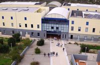 Akrotiri,Hania at 42.8km (E) The Technical University of Crete, one of Greece’s Higher Education Institutions, which places emphasis both on education and research, was established in 1977 in Chania Crete and admitted its first students in October 1984. Today, the Technical University of Crete comprises 5 academic engineering departments, the Department of Production Engineering and Management, the Department of Mineral Resources Engineering, the Department of Electronic & Computer Engineering, the Department of Environmental Engineering and the Department of Architectural Engineering, assisted in their curriculum by the Sciences Department, all of which have set very high objectives. 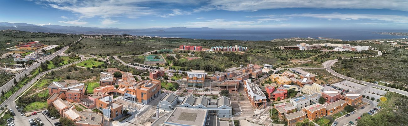 The Campus is built on a panoramic location in Kounoupidiana, Akrotiri, 7 km northeast of the city of Chania, with a total area surface of 290 hectares. Off campus, the Department of Architectural Engineering is located at the former French School in Halepa whereas the Rectorate and the rest of the administration offices are located in the heart of the old city of Chania in the Venetian complex of the old barracks and prison. Website (GR) :http://en.tuc.gr/contact-en.html Website (EN) :http://en.tuc.gr/contact-en.html Contact Information at:http://en.tuc.gr/contact-en.html  Sfakia, South Hania at 45.6km (SE) Ágios Pávlos (GR: Άγιος Παύλος)is a beach on the shores of Sfakiá between Agia Rouméli and Loutró. The pine trees from the high cliffs above almost reach the sea and form a unique landscape. The beach is sandy with pebbles with no facilities except for a small tavern. It can be reached only on foot ( about 1 hour walk from Agia Roumeli) or by boat. The picturesque small church of Agios Pavlos (Saint Paul) a byzantine basilica of the 10th century A.D. with frescoes, lies just a few meters from the sea. It is built with stones from the beach itself on the spot where Saint Paul reportedly baptised people on his way to Rome.
Image Library
 Hania at 47.9km (E) A guide to the area of Akrotiri. Tourist facilities, regional information and image gallery. Akrotiri with its scenic landscape provides a relaxing, refined country break away from the pressures of urban life. Its numerous monasteries, from the oldest in Crete, played a significant role in the history of the area. Gorges of outstanding beauty offer a unique hiking experience, breathtaking views and the joy of exploration...
Image Library
 Aptera, Apokoronas, Hania at 49km (E) One of the most important city - states of Crete. The first epigraphic occurence of its name (A-pa-ta-wa) is found in the Linear B tablets found at Knossos. (14th - 13th century B.C.). The history of the city is continued through the centuries untill the 7th century A.D. when a major earthquake destoyed it. Its ideal location, allowed the city to control the naval activity in the bay of Souda, and was determinative for its development in an important commercial center. The era of the city's greatest peak was the early Hellenistic period (late 4th - 3rd century B.C.). At that time Aptera experienced an economical and political floruit, begins to mint its own coins and develops diplomatic relations with important centres of the Hellenistic world.
The most important monuments of the site are: Roman cisterns. Bipartite temple, known as the "bipartite sanctuary", dated to the 5th-4th century B.C. Graves of the Geometric-Roman periods. The fortification wall, preserved to a length of almost 4 kilometres. Part of a Roman bouleuterion. Byzantine buildings. Monastery of Agios Ioannis Theologos. Turkish fortress built in 1866-1869. Source: The Hellenic Ministry of Culture  article by Stelios Asmargianakis at 49km (E) An article where Stelios Asmargianakis describes his experience of sea kayak, through a two-day trip to the north of Chania as it took place in mid February 2012. The whole journey is about 40 km, and is characterized by the absence of beaches for easy approaching and relaxing as well as exposure to the elements of the Cretan Sea.
|
|||
|
| |||


C
O
N
T
E
N
T
S
O
N
T
E
N
T
S