interkriti®
YOUR GATEWAY TO CRETE
HOME
CRETE FACTS
NAVIGATE
EXPLORE

Agia Galini
Triopetra
Kissamos
Chryssi Isl.
Agia Marina
Balos
Gavdos isl.
Georgioupolis
SAMARIA
IDA Mtn
Palaiochora
Agia Roumeli
Sfakaki
Bali
Kalamaki
Matala
Lassithi
Plateau Lendas
Tsoutsouros
Vianos
Myrtos
Sfakia
Plakias
Ierapetra
Makrygialos
ZAKROS
Vai
Sitia
Agios Nikolaos
Elounda
MALIA
Hersonissos
Gouves
Chania
Rethymnon
Heraklion
GORTYN
FESTOS
KNOSSOS
|
|
Crete
: Regional Interest
List Grid Map
Found
86
- Showing :
41 - 60
 Pediada, Iraklion at 35.4km (NW) Krassi is a small village 47 Km's from Iraklion and 17 km from Malia at an altitude of 600 m.asl, on the way to Lassithi plateau, and is administratively part of the Municipality of Malia. The village is one of the prettiest in Crete, with a lot of springs. Due to the free running water , it is covered with walnut trees, plane trees and all kinds of vegetation. Next to the spring in the middle of the village is one of the oldest and biggest plane trees in Crete (its root has a circumference of 22 meters!).  Selinari, Vrahassi at 35.9km (NW) Near the beautiful village of Vrahasi there is the imposing gorge of Selinari, formed by the mountain of Anavlohos (625 m) to the north and the mountain Fonias o Detis (818 m) to the south. The symbol of Crete, the Cretan wild goat (Agrimi or kri-kri) and the Griffon Vulture are two rare species that used to reside in the gorge. The authorities in Vrahasi intend to establish a center of protection of the local fauna and flora at the gorge of Selinari and to develop a wildlife station, to provide observation of the Griffon Vulture colony at the east side of the gorge of Selinari. The hunting is forbidden in an area covering 10 sq.km. around the gorge.  Mirabello, Lassithi at 36km (NW) At the side of the gorge of Selinari, at the 42 km. of the national road Iraklion - Agios Nikolaos is the small old chapel and the newly founded monastery of Agios Georgios Selinaris. In the monastery there is also a home for the aged founded in 1963. The small chapel was probably founded early in the 16th century AD, and ever since it is a place of worshiping. The people passing through the chapel stop to light a candle to the saint. The chapel is considered miraculous, there are various legends concerning miracles related either with healing of sick people or with divine punishment of people that did not pay the respect due to the saint.
 Sitia, East Crete at 36.4km (E) The Agia Triáda (Holy Trinity GR: Αγία Τριάδα)) Community is 35 km from the town of Sitia at the end of the plateau of Ziros, with a population of 156. Long ago, the village was called Tso and today it is named after the Cathedral. Despite of the 8 km distance from the sea, its residents are very good fishermen. The Agia Triada Community includes the smaller communities of Dasonari, Livari, Achladi, Stalos and Amigdali. The archaeological search gave many indications of ancient features especially in Stalos where a Minoan settlement and some vaulted tombs were brought to light. In the area of Livari there is a Minoan cave the Alogara. 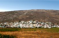 Sitia, East Crete at 37.4km (E) The hilly village of Ziros (GR: Ζήρος) spreads over the lower slopes that the locals call Egremno (the Cliff) at an alti-tude of 590 m. at the pictureque Armeni-Handras plateau. The village is the seat of the Municipality of Lefki. The village was first recorded as Siros in 1577 in the Venetian Barozzi's catalogue of the villages of Sitia. In a census carried out by the P. Castrofilaka it was listed under the same name in 1583, with a population of 448. In 1928 with the first census after the union of Crete with Greece, the population was 742. Today the population of the village is approx. 742 but diminishing. The Ziros community includes the villages of Kalo Horio, Hametoulo, the coastal settlement of Xerokampos, the deserted Lamnoni and some settlements inhabited seasonally like Agrilia, Lethi, Achladias, Makri Livadi and Anargyros. The Ziros area has many antiquities from all periods, however no methodical excavations have yet occured. Ancient sited can be found at Plakospilios (roman settlement and tombs), St. John (an Archaic set-tlement), Fonias (a Minoan settlement), Stalos (Minoan tombs and settlement), Katsoulianos (Minoan tombs), Pentalitro (Minoan Acropolis), Katergari Papa Pigadi (Minoan Settlement), Anemomilia (Minoan building), Pirgales (Minoan Villa), Vrisi Hametoulou (Minoan settlement), Limnia or Palaki Mantra Hametoulou (Minoan buildings). An important peak sanctuary of the Middle Minoan period existed at the Plagia hill but now it is ruined. The Ziros area is dotted with caves and also other geological features, the most important are: the cave of Agrilia, the cave of Lygias Spilios and the cave of Voevodas. The Ziros area has also many remarkable churches to show with the most important from all the painted church of St. Paraskevi dated back to 1523. The St. Nikolaos church has graffiti dated back to 14th and 15th century. 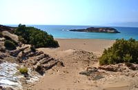 Sitia, East Crete at 37.6km (E) Koufonisi is a small island in the Libyan Sea just off the South East coast of Crete and the Cape of Goudouras. It is also named LEFKI and gave its name to the municipality. There is a cluster of small islets in the area like Makroulo, Strogylo, Trahila and Marmara. The island is deserted and in many spots it is covered with sand reminding an African landscape. Until 1976 the shepherds used to feed their sheep there but it was not inhabited. Later the Archaeological Offices of Eastern Crete under the authority of N. Papadakis began the excavations and the island proved to be full of ancient sites. A beautiful theater, made of stones, at the North West end of the island opposite the Marmaras islet was discovered. At the South East of the theater where a settlement was found, a villa with 8 rooms and a guest room was brought to light. The excavations also showed a workshop where the famous purple robes of the Romans was made. They also dig out an astonishing building, the Public Baths, dated back to 1st and 4th A.D. and ruins of an old temple. Boats depart daily from Makrygialos to Koufonissi (during the tourist season and only if the weather permits) offering day-trips. A short description of Lefki, by the archaeologist Nikos Papadakis: Koufonisi island covered today with sand and bushes, lies close to the southeast shore of Crete. From the Middle - Ages until today is nowhere referred that the island has ever been inhabited permanently. However scattered ancient remnants, drew the attention of the English admiral and traveller T B. Spratt in the mid - 19th century. His itinerary and visit was repeated by the English archaeologists Bosanquet and Curely in 1903 and by the American A. Leonard jr in 1970. The definite conclusion all the above travellers reached was that Koufonisi could be identified with the island Lefki of antiquity for which the people of Itanos and Hierapytna were contending as it is referred in the famous "Inscription of Magnetes" of 112 - 111 B.C. Excavations and archaeological research have since 1976 taken the responsibility to answer to the questions almost innate and consequent to the above conclusion and the result is undoubtedly impressive: An entire theater that could have housed a thousand spectators: a temple still containing fragments from the colossal cult statue: two private houses with 17 rooms decorated with mosaics and colourful walls: a system supplying water to the city through a series of vaulted cisterns and built pipes: a Minoan acropolis: cemeteries and last but not least the city of Lefki itself. Thus, slowly but steadily is unveiled the short but impressive presence of this small island nearby east Crete. Judging from the so far finds we can say that Lefki being one of the major centers of processing and trading purple, a symbol of authority and economic power soon became the object of rivalry among its neighbours. A series of diplomatic intrigue and fighting had occurred over the dominance of this prolific island. Later when its sources of prosperity were depleted the people of Lefki were exterminated through arms and fire: an invasion in the 4th century A.D. turned the historic island into ashes. On the basis of the existing ruins the importance it had for its neighbours and the fact that it was never again inhabited after its destruction we may describe Koufonisi by quoting a western journalist as Delos of the Libyan Sea.  Sitia, East Lassithi at 37.8km (NE) Piskokéfalo (GR: Πισκοκέφαλο), a principal village located 3 km south of Sitia. Piskokefalo is the birth place of the great poet Vincentzos Kornaros, who wrote the masterpiece of Medieval poetry, "Erotokritos". The village is mentioned at the census of 1577 by Fr. Barozzi, and became the seat of the commanding officer, after the destruction of the town of Sitia in 1538 by the pirate Chairentin Barbarossa. Nowadays Piskokefalo is a beautiful village where a stop is worthwhile. The visitor can see the house of Kornaros, enjoy a coffee or a meal at the village's square, visit the spring at Zou, the old water mill, the church of "Agia Anna" and the small chapel of "Panagia Trapezounta".  Pediada, Iraklion at 38.7km (NW) Geraki (GR: Γεράκι). This lovely village of 375 inhabitants is located on the western slopes of the Lassithi mountains between the peaks of Afendi (1578 m) and Sarakinos (1588 m) in a beautiful glen, 520m above sea level and only 9km SE of Kastelli. It features an interesting Byzantine church, dedicated to the Archangel Michael (Archangelos Michail) with wall paintings that have not been maintained and some interesting (movable) icons by the local painter, Sepis. The active cultural centre of Geraki organizes many events during the summer season. Twice a year the village has a typical Cretan feast in honour of its patron saints: Agia Paraskevi on July 26th and Michail Archangelos on 8th November. The village produces agricultural products and great cheese that led to a specific cheese celebration. From Geraki you can also reach the lovely chapel of Agia Anna, driving through a particularly beautiful landscape with a spectacular view over the Geraki glen and fresh running water, a place ideal for a picnic. Image Library
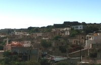
 Pediada, Iraklion at 38.8km (NW) Kastamonitsa (GR: Κασταμονίτσα) is 7 km away from Kasteli, has 356 inhabitants and lies at 520 m above sea level, in the foothills of the Afendi mountain (1578 m), with the Dikti mountain in the background. The village is not mentioned in the Venetian registers of the 16th and 17th centuries, nor in the Turkish census of 1671. It is possible that the name is related to that of Kastamoni in Asia Minor: refugees, driven out of their land by the Turks, may well have come and settled here, giving their new home the same name as their old one. But it is impossible to establish a precise date. The Church of the Koimisi tis Theotokou (Dormition of Our Lady), located in the cemetery of the village, has wall paintings of the 14th century and points to a settlement here during the Venetian period. However, as we said before, the village is not mentioned in any Venetian census. The first reference is to be found in an Egyptian census conducted in 1834, where the village of Kastamonitsa is said to have 35 Christian families. And again in 1881, the village is said to have 320 Christian residents; no Turkish families are mentioned. The location of the village on the way to the natural fortress of the Lassithi plateau which protects all of Eastern Crete, turned the area into a battlefield during the last century. The Egyptian Pasha Hassan tried to invade the Lassithi plateau in 1822. The rebels cut him off between Krassi and Kastamonitsa, fighting him so well that he was forced to change his strategy and invade the plateau through its south side (Viannos and Ierapetra). Other fierce battles took place in and around Kastamonitsa during the 1866-67 rebellions. Finally Omer Pasha, known as the Attila of Lassithi, found a way up through the glen at Geraki where an betrayer showed him the way. A clay cast has been found in Mesarmi. It is elliptical in shape and has a width of about 0.25 m, and has a plaited decoration. A round glass vessel was also found at Xidiano Seli. 4 km out of the village you get to a lovely spot known as Mesada, where traditional celebrations take place on Easter Tuesday.The village boasts of several kapheneions and a taverna in the main square. There is an active cultural centre, that organizes events especially in the summer. The most important and traditional feast is held on July 7th in honour of Aghia Kyriaki. Image Library
 Pediada, Iraklion at 38.8km (NW) Mathia is 11 km to the SE of Kasteli, has 215 inhabitants and lies at 590 m above sea level, in the foothills of the Afendi mountain (1578 m), with the Dikti mountain in the background. The earliest reference to the village can be found in several contracts of 1271 where the notary of Chandax P. Scardon mentions commercial exchanges of grain and wine with residents of the village ‘Mithie’, possibly a misspelling for Mathia. The name derives from the common first name for girls, ‘Mattia’, which in Crete is pronounced ‘Mathia’. Burials in jars of the middle Minoan period were discovered in 1957 close to the village, in a place known as Stavroplaka. To the NW of the village, at Katalimata, a Late Minoan site with important finds and, 200 m further off, a settlement with large walls still in place were also found.There are wonderful Byzantine wall paintings in the two churches of this traditional village, the church of Koimisi tis Panagias (Dormition of Our Lady) and the church of Agios Giorgos. At Metochi, in beautiful surroundings where the historical holm-oak of Ismail Pasha stands among plane trees and running water, there are camping facilities. You can also visit an old factory and several ruined mills. The village boasts of several kapheneions where they serve raki and ‘mezedes’ (tit-bits). There is an active cultural centre, that organizes events especially in the summer, with evenings of Cretan music and theatre plays. The most important and traditional feast is held on the Sunday of Agioi Pantes, 50 days after Easter. Image Library
 Pediada, Iraklion at 38.9km (NW) Amariano, a charming small village of 321 inhabitants, (census 2001), lies in the western foothills of Afendi mountain, at an altitude of 530m. It is located at 7, 2 km east of Kastelli and can be found on the road axis; Kasteli -Xidas- Kastamonitsa-Amariano. With the traditional, century old plane tree in the middle of the village square, with the fountain, surrounded by kafeneions (traditional cafes) serving refreshments; raki (or tsikoudia, the traditional Cretan spirit) and mezedes (tit-bits), Amariano is a typical Cretan village, well worth a look. Until recently, the leather tannery was a main activity among the villagers. The main produce today are olive oil, raisins and grapes, although there is also livestock. Close by is the church of Agios Giorgos Kefaliotis with good quality wall paintings. The cultural centre of Amariano organises a great feast on August 15th, the Dormition of Theotokos and on September 20th, day of the patron saint, Aghios Eustathios. This can be a great occasion for any visitor to live an authentic cultural experience, to meet the people and taste the traditional Cretan cuisine. The first mention of the village -Amariano and Mariano- is to be found in inscriptions dating back to 1394-1399. Fr. Barozzi also mentions it in the region of Pediada in 1577. The name is significant: Amari is an area close to the town of Rethymnon, therefore the first inhabitants were originally from the Amari region. During the second Byzantine period, this region was known as Apano Syvritos and the name Amari is first mention in Venetian times. This would imply that the village was first founded during the Venetian conquest of the island. The first spelling, Amarianos, is the correct one and the family names Amarianos, Amargianitakis and Amariotis first appear in the 16th century, in the 1583 cencus. Image Library
 Archaeological site in Malia, Iraklion at 39.1km (NW) The Palace of Malia, which covered an area of 7,500 sq.m. , was the third- largest of the Minoan Palaces and is considered the most "provincial" from the architectural point of view. The first Palace was built in 1900 BC and destroyed in 1700 BC when a new Palace was built. Following the fate of the other palaces in Crete it was also destroyed in 1450 BC. and the present ruins are mainly those of the new palace.
 Mirabello, Lassithi at 39.3km (NW) The village of Sissi, a picturesque village 40 km east of Heraklion and 25 km west of Ag. Nikolaos. Sissi is a beautiful fishing village with strange nature. On one side of the village the nature is wild, with a small river flowing into the sea, a number of palm trees on its banks, ducks and geese swimming peacefully. On the other side there are sandy and gravel beaches, caverns in the rocks and deep clear water, full of many kinds of fish. A place that gathers the nature of different places of Crete.
 Pediada, Iraklion at 39.4km (NW) Armacha (GR: Αρμάχα) lies at 490 m above sea level, at a distance of 7km from Kastelli, with 110 residents (census 2001) and is first referred to by Barozzi in 1577. Armacha is rich in the production of agricultural and livestock products. The Metropolitan Bishop, Tirnovos Voulgaria Ilarionas Kabanaris Sinitis was born, and is also buried here. A man of advanced learning, he wanted to translate the Bible to Demotic Greek.  Pediada, Iraklion at 39.8km (NW) Askoi (GR: Ασκοί) is small village in the municipality of Kasteli has 315 inhabitants. It lies in the foothills of the Dikti mountain, 11 km to the east of Kasteli and 8 km from Lyttos. Fr. Barozzi mentions it as Ascus, in the Pediada district, in 1577. Recently a ritual clay figurine of the Mid-Minoan period was fortuitously unearthed on a peak close to the village. The remains of a large building belonging to a peak sanctuary have been excavated at Amygdalokefalo to the NE of the village. A reference in a contract of 1271, mentions how Petri Comarii from the village (casali) Maski owes Ruggerino Temisano, resident in Chandax, 25 «mistata» of good Cretan wine from his vineyards in Maski. Among other natural beauties, the ravine at Aski is well worth seeing. On December 4th the village has a typical Cretan feast to honour Agia Varvara. And as in every Cretan village, raki and ‘mezedes’ are always available at the kafeneions. Image Library
 Pediada, North - East Iraklion at 39.9km (NW) The famous tourist resort with all types of accommodations. Great beaches and a lively party atmosphere particularly in August. Becomes pretty quiet and peaceful during the rest of the season and there is a nice and picturesque part of the old village that preserves the traditional character. Malia has also a significant agricultural production and is famous for its bananas, potatoes and bottled water.
 Sitia, East Lasssithi at 40.2km (NE) The easternmost town in Crete. A small and pleasant coastal town, built in a semicircle on the western side of the Bay of Sitia (Si̱teía GR: Σητεία), a typical, peaceful Mediterranean port. It is the capital of the county with the same name and is sited 69 km east of Agios Nikolaos.
Image Library
 Kasteli, Pediados at 40.5km (NW) The ancient city of Lyktos or Lyttos (GR: Λύκτος / Λύττος) was one of the most ancient and powerful towns in Crete. Although the excavations in the area reveal traces of habitation from the Hellenistic years onwards (630 B.C.), the archeologists Georgios Rethemiotakis and Angeliki Lempesi have excavated traces of habitation from the time of the destruction of Lyttos by the Knossians (219 B.C.) in excavated residences of the Hellenistic period. From the Roman period, the city was subject to new workings as testified by the architectural remnants and the many inscriptions and statues discovered. Numerous vestiges of ancient structures, objects, and broken marbles are seen, as well as an immense arch of a Roman aqueduct, by which the water was carried across a deep valley by means of a wide marble channel. Traces of the aqueduct which brought its water supply from Kournia, near Krasi village, are still visible today in the rural road to Kastamonitsa village. Lyktos had also a theatre, built in the slope of the hill the design of which we know only from the drawings of Belli (1586). Finally, the most important discovery is that of a room of nearly 14 metres by 11.40 metres, with marble flooring and a series of four stone platforms along its two longer sides. The room was erected, according to the inscription that was found at the site, at the beginning of the second century B.C. This room was identified as the chamber of the Roman deputies of the city and was very probably destroyed by an earthquake at 365 AD. Lyktos appears to have still been inhabited in the 7th Century AD as indicated by the excavation of late-roman shops in the area. (Late Roman Empire, 284-610 AD)  Pediada, Iraklion at 41km (NW) Built at 510 m with 319 people Ksidás (GR: Ξυδάς) also known as Lyttos, is located at 3 km from Kastelli in the foothills of the site of the ancient town Lyttos. The first mention of the village goes back to 1368AD, with the name Ksidas. A burial site was discovered when the road was being constructed, at Chomatolakkos, belonging to late Roman period. Two gold rings have also been found here, the one with stone, showing the portrait of an emperor holding a spear, and the other with a hoop, showing two interlocking hands. A bronze ring with a Greek inscription, along with golden plates and bronze coins, were also found at this site. Image Library
 Monofatsi, South Iraklion at 41.1km (W) Tsoutsouros (GR: Τσούτσουρος) is a small village on the southern coast of Iraklion prefecture, with lovely beaches and a small harbour. The ancient city of Inatos, used to stand were Tsoutsouros is now. Inatos served as a port to Priansos a renowned city - state of the Hellenistic time, located near the village of Kasteliana. Tsoutsouros is a popular tourist resort especially with Greek families. There are many taverns and cafes most of them around the small harbour, and a good choice of apartments and hotels along the beach. Image Library
|
||
|
| ||


C
O
N
T
E
N
T
S
O
N
T
E
N
T
S