interkriti®
YOUR GATEWAY TO CRETE
HOME
CRETE FACTS
NAVIGATE
EXPLORE

Agia Galini
Triopetra
Kissamos
Chryssi Isl.
Agia Marina
Balos
Gavdos isl.
Georgioupolis
SAMARIA
IDA Mtn
Palaiochora
Agia Roumeli
Sfakaki
Bali
Kalamaki
Matala
Lassithi
Plateau Lendas
Tsoutsouros
Vianos
Myrtos
Sfakia
Plakias
Ierapetra
Makrygialos
ZAKROS
Vai
Sitia
Agios Nikolaos
Elounda
MALIA
Hersonissos
Gouves
Chania
Rethymnon
Heraklion
GORTYN
FESTOS
KNOSSOS
|
|
Crete
: Sightseeing
List Grid Map
Found
80
- Showing :
41 - 60
 Messara, Iraklion South at 35.3km (SE) Located in the valley of Messara, Gortys or Gortyn (GR: Γόρτυς or Γόρτυνα) is a must visit for all visitors to Crete. It was inhabited during Bronze Age times, but its rise to glory came almost a millennium after the downfall of the 'Minoans'. Gortyn was a prosperous city from around the middle of the 5th century BC through to the early 9th century AD, when it was finally destroyed by the Saracens (824AD), never to be rebuilt.
Image Library
 Gortyn archaeological site at 35.4km (SE) This unique monument has been excavated in the last thirty years. It is located on the road between the Saint Titos Church and the village Mitropolis. It is the largest early Byzantine basilica in Crete and among the largest in whole Greece. In early Byzantine period it was the cathedral of the city. The first five-aisled basilica was erected here in the early 6th c., in the years of the Emperor Justinian and stood for about 70 years. The central aisle had a mosaic pavement decorated in geometric patterns and animals. It is believed that there were mosaics of stone and glass tesserae on the walls, too. The other aisle had pavements of limestone slabs. The columns were made of white and gray white marble. Of great importance is the pulpit, which resembles that of Saint Sophia in Constantinople. It was a high exedra on low columns and two stairs for ascent and decent. The choirs stood under the exedra. After the destruction of the first basilica in 620 AD, a new basilica was built over its ruins in the time of the Emperor Heraclios. This basilica, following the fortune of the whole city, was destroyed after the strong earthquake of 670 AD.
Image Library
 Gortyn at 35.6km (SE) The Temple of Apollo Pythios (Pythian Apollo) located in the center of the ancient Agora, was excavated in 1887 and was the largest temple and the religious center of ancient Gortyn until the introduction of Christianity and the founding of the basilica of St. Titus around 500 AD. The first building of the seventh century. BC was a four-sided enclosure with four wooden pillars in the center to support the roof. The exterior walls and stairs of the crepis were covered with archaic inscriptions. In the Hellenistic period a monumental anteroom was added while columns with inscriptions were placed between the pillars. Alterations and additions were made during the Roman period. Outside the temple was built a magnificent altar on a stepped base while in the west of the temple was built a small theatre. In the middle Byzantine period in the vicinity of the temple, which had been abandoned, were built houses and aqueducts. Many finds have been made in the temple among which the colossal statue of Apollo Pythios and many inscriptions with administrative and law content of the Archaic and Hellenistic period. Dates: 7th c BC; Hellenistic; 2nd c AD. Image Library
 Gortyn archaeological site at 35.6km (SE) The sanctuary of the Egyptian deities (1st-2nd centuries A.D.) is the only one, in the whole island, which is dedicated to the Egyptian gods Isis, Serapis and Anubis - Hermes although it is known that those gods are worshiped in other cities. The sanctuary consists of quadrilateral nave, arcade on the west, underground crypt in the south and a cistern outside east of nave. In the central alcove stood the statue of Serapis and the side statues of Isis and Hermes - Anubis. In the southern part of the temple was oblong space, underground crypt purification and a small cictern. The final construction phase of the temple dates to the 1st / 2nd century. AD, in accordance with dedicatory inscription. Image Library
 Gortyn at 35.7km (SE) The Praetorium was the seat and residence of the proconsul of Crete. It is divided into two parts: the administrative section, in which the central building is the basilica, and the more "private" sector. The preserved ruins are dated to the 2nd century A.D. and seem to have been repaired in the 4th century A.D. This totally excavated building is the largest in the whole City of Gortyn. The earliest constructions have suffered successive alterations in a long period of eight centuries. New structures were erected on the ruins of the earlier sometimes incorporating parts of them. In the 1st c AD the Praetorium consisted of a peristyle court 1000 sq.m. and large halls to the north and west. This first Praetorium was destroyed by an earthquake in the time of the Emperor Trajan (early 2nd c AD). It was reconstructed and a large Thermai complex was built at its east side. Some years later a large temple dedicated to the Augusts was built further at the east part. To the west of the Thermai the juridical basilica continued to function under a judge’s responsibility according to the inscriptions found there, and statues of the emperors and other officers were still standing there. All these famous buildings were destroyed by the large earthquake in 365 AD. In 383 the consul Oecumenius Asclepiodotus Dositheus, agreeing with the capital of the empire, took care of the construction of the new Praetorium. Image Library
 Gortyn archaeological site at 36km (SE) It lies at the south eastern part of the city and it is considered to be largest of all theaters in Gortyna. Although it is not yet excavated, it is believed that it had a two storeyed stage and its cavea was supported by 56 arches. The statue of the seated philosopher that we see next to the exhibition hall of the archaeological site was found here.
Image Library
 Gortyn archaeological site at 36.2km (SE) The Hippodrome was located in the south part of the city of Gortyn, and was surrounded by columns. The central section was 374 metres long and 60 metres wide. Our information on the site is insufficient for the reason that there was never a systematic survey, or even a small excavation. What we see today of this magnificent monument are only some parts of columns and capitals.
Image Library
 Messara, Iraklion South at 36.4km (SE) Agioi Déka (GR: Αγιοι Δέκα) is a town with 820 inhabitants in the plain of Messara, 170m above sea level, 43 km from Heraklion town and very close to the archaeological site of Gortyna. Its people are occupied mostly in agriculture - vines and olive trees. In the area there is is the oldest olive grove in Crete. The town is built on the ruins of the ancient town of Gortyn where the Holy Ten Martyrs have been martyred.  Sfakia, South Hania at 38km (W) On the south coast of Crete, on a magnificent white sandy beach, stands one of the most beautiful Venetian fortresses, Fragokastello, built in 1371. It is located approximately 170 km from Iraklion, 70 km from Rethimnon, and 70 Km from Hania. Today, Fragokastello is a small, but developing, community, with nice beaches covered in sand dunes, and limited, but increasing, tourist facilities.The Villages Patsianos and Kalikratis, the castle, the history of the place and the fenomenon of Drossoulites...
 South - coast Iraklion at 38km (S) Martsalo (GR: Μάρτσαλο, Mártsalo) is located on the mass of the Asterousia Mountains between Kefali (Cape Lithino) and Agiofarago. It is an impressive gorge about two kilometers long, which belongs to the hermitages of the Holy Monastery of Odigitria. Inside the gorge there is rich vegetation as well as a small palm forest in the middle of its route. The impressive cliffs are home to a large number of caves (similar to eagles' nests) inhabited by many of the area's ascetics. Gorge Martsalo is particularly steep and rough and ends at the Libyan Sea, where there is a small protected cove with a sandy- pebbly beach. Image Library
 South - coast Iraklion at 38.8km (S) Agiofaraggo (GR: Αγιοφάραγγο the gorge of Saints) is a small gorge at the southern shores of Heraklion close to the village and the beach of Kaloi Limenes and 6 kilometers south of the Monastery of Odigitria. Image Library
 Gavalohori, Vamos, Apokoronas at 43.3km (NW) The exhibition of the objects takes place according to the contemporary museum conception, with explanatory texts, photographs, plans, models, and is enriched with new exhibits every year. The Museum is divided into seven rooms, according to the following units: The Arched House, Silk, Pottery, Lace-making, Masonry and Stone carving, Church and Woodcarving.
 Lentas, South Iraklion at 44.4km (SE) The first habitation of the site dates from the Neolithic and Early Minoan period (3rd millenium B.C.). In the late Classical period (beginning of the 4th century B.C.) the Gortynians established the sanctuary of Asklepios at the harbour. During the tremendous earthquake of 46 B.C. the city was destroyed and subsequently rebuilt. In the Early Christian and Byzantine periods, a small settlement developed and the basilica was erected. The most important monuments of the site are: The Temple of Asklepios., the "Treasury"., the Fountain, a large, three-aisled basilica, an Early Minoan settlement (2600-2000 B.C.), the West Stoa, the North Stoa, the Nymphaion and two large, mud-brick cisterns. 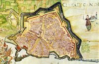 Iraklion at 44.7km (E) The fortified enclosure of the Venetian Chandakas of the 15th century, which is still preserved today, is one of the most significant monuments of its kind in the whole Mediterranean basin. Triangular in shape, with its base at the sea, the mighty enceinte has a perimeter of about 5.5 kilometres. The hallmark of the defensive layout are the bastions, linked by curtain walls decorated at many points by escutcheons and the lion of St. Mark, symbol of Venetian omnipotence. The gates in the enceinte, which served to link the town to the countryside, still stand as important architectural monuments. To this day, the walls that withstood the Ottoman siege in the mid-17th century mark out the boundary of the old town. 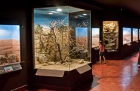 Iraklion, Dermatas Gate at 44.9km (E) The Natural History Museum of Crete is housed in the renovated former premises of the Heraklion Public Power Corporation, on Dermatas’ Bay. With an area of 3,500 m2, it is the largest exhibition of its kind in the Mediterranean, showcasing the natural environment of Crete and the wider Mediterranean area in an innovative, original way.  Iraklion at 45km (E) The bastion heart shaped in plan with an acute angle, has two "piazza bassa" and one cavalier. It defines the southeast and the highest part of the fortification. Its name is due to Gabriele Tadini Martinego (1520) who started the construction of a circular tower at the place of the later bastion. It was one of the strongest bastions (the others were that of Pantocratora and that of Vittouri) which also suffered the main attack and most of the bombardment from the Turks. On the top of the bastion itself there was made a cavalier (which looks like a smaller bastion), whose main purpose was the better defense and control of the area around the bastion. The grave of Nikos Kazantzakis, the famous Cretan writer, is situated on the highest point of the Venetian fortification at the Martinego cavalier. The inscription by the wooden cross reads: " I hope for nothing. I fear nothing. I am free ", a phrase taken from "The Odyssey" which Kazantzakis considered as one of his most significant works. The playgrounds of the Academy of the local football team "Ergotelis" are located today on the main bastion and in the ditch around the bastion are the botanical gardens of the city. Image Library
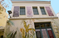 Iraklion city, Heraklion at 45.1km (E) In the heart of the city center of Heraklion, opposite the church of Agios Minas, is the Museum of traditional music, instruments, research & documentation with the characteristic title 'Thirathen'. The Museum was founded in 2012 with its headquarters in the historic village of Krousonas, in the Municipality of Malevizi. In December 2023, it opened its doors to the public, in its new space in the center of the city of Heraklion.  Iraklion Old Town at 45.1km (E) The Cathedral of St. Minas:The small church of St. Minas did not meet the religious needs of the constantly growing Christian community, so the demand arose for the erection of a new cathedral. The plot for the new church used to be a garden that belonged to a Turk from whom it was bought. The architect was Athanasios Moussis and in 1862 the foundation stone of one of the most magnificent and impressive Greek churches was laid. The outbreak of the Cretan revolution of 1866 demanded the stopping of the building work which will continue in 1883 in order to be completed in 1895, when the inauguration of the exquisite temple took place. The church is of the cruciform type with a dome based on a high spandrel, while internally there are also elements of a three aisle basilica. It has two bell towers, one in the northeastern corner and the other in the southeastern one. The right aisle is dedicated to Apostle Titos and the left one to St. Ten Martyrs of Crete. The inside of the church has gone through many changes with new additions. With plans of the architect Anastasios Orlandos the woodcut icon screen was replaced by another one made of marble, the same happened with the bishop's seat. The religious painting of the church was assigned to St. Kartakis who followed faithfully the principles and the models of the Byzantine icon painting. The hundredth anniversary from the inauguration of the Cathedral Church of St. Minas (1995) was celebrated with every solemnity that is suited in an equal occasion and more specifically to one of the most glorious and imposing Greek churches. Image Library
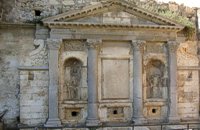 Iraklion at 45.1km (E) The «General Provisioner» Antonio Priuli made it in 1666 and it is situated today behind the "Bodosakeio" Primary School (in the area of the Venetian Dermata Gate). He decorated it with round and square columns with Corinthian type capitals, while a triangular pediment crowns the whole construction. From both sides of the columns there are niches with their metopes elaborately decorated. In the middle of the fountain there is a Turkish inscription where there is a reference to the name of the Turkish pasha who managed to bring water again in the fountain.
 Iraklion at 45.2km (E) Agia Ekaterini church and Exhibition of Byzantine Art and Ecclesiastical objects. A small sinaitic church of St. Catherine with a Basilica design, houses an exhibition with works of art from the Cretan renaissance. Among the exhibits are some of the most important icons of the Cretan School, ecclesiastical books and manuscripts, vestments, ecclesiastical vessels and relics, wall-paintings, wood-carvings and sculpture. |

|
|
|
| ||
C
O
N
T
E
N
T
S
O
N
T
E
N
T
S