interkriti®
YOUR GATEWAY TO CRETE
HOME
CRETE FACTS
NAVIGATE
EXPLORE

Agia Galini
Triopetra
Kissamos
Chryssi Isl.
Agia Marina
Balos
Gavdos isl.
Georgioupolis
SAMARIA
IDA Mtn
Palaiochora
Agia Roumeli
Sfakaki
Bali
Kalamaki
Matala
Lassithi
Plateau Lendas
Tsoutsouros
Vianos
Myrtos
Sfakia
Plakias
Ierapetra
Makrygialos
ZAKROS
Vai
Sitia
Agios Nikolaos
Elounda
MALIA
Hersonissos
Gouves
Chania
Rethymnon
Heraklion
GORTYN
FESTOS
KNOSSOS
|
|
Crete
List Grid Map
Found
94
- Showing :
61 - 80
 Ierapetra, Lassithi at 33.8km (SW) A monument of natural beauty that attract a lot of local and foreign visitors. The gorge of Sarakina (GR: Σαρακίνα) is one of the most beautiful in Crete. Its steep, vertical walls in some parts reach a height up to 250 m. Its widest opening is no more than 15 metres while in some places it’s so narrow that its sides seem to join each other. Its rich flora and fauna, the dittany, the wild birds that nest there, the running water make the route through the gorge a worthwhile experience. 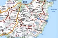 Richard Ellis walk: Day 1 at 33.9km (E) The E4 path out of Zakros starts a short way south of Hotel Zakros on the main road and is signed up to the right along with signs for old water mills and the like. You have to poke about a bit in the upper levels of Zakros to be certain of being on the right path but upwards and westwards is the key. Distance:6.7 km Time: 1.5 hrs. Mov av 4.9 km/hr Height overnight: 225 m. 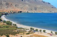 Kato Zakros at 34km (E) Small coastal village at the eastern edge of Crete. Here in 1961 a great Greek archaeoligist, N.Platon, unearthed the fourth largest Minoan Palace. Nowadays in Kato Zakros (GR: Κάτω Ζάκρος) live a few people, occuping with farming, and fishing. There are a few taverns and cafe bars available for the visitors as well as a few rooms for rent. The scenery is great and the sandy beach with crystal clear water is one of the nicest in eastern Crete. Apart from a visit to the Minoan site the visitors can take a walk through the imposing gorge of the dead or follow the path along the coast to the cave of Pelekita
Image Library
 Ierapetra, Lassithi at 34km (SW) Deep inside the valley of the river Sarantapihos is built the village Mythoi. It is 22 km away from Ierapetra, it is a small village, in a verdurous landscape,with a beautiful square under the shade of age-old planes. It is said that the village took its name from the plant “Minthi”, or mint, which is abundant there.However, it may have been named thus because of its many legends, traditions, and myths (mythoi), the most prevalent one being the Sarantapihos’ one. A mythical giant, forty ells tall, like another Talos or Akritas Digenis, he protected the residents from raids. There are the place names “Tou Sarantapihoui Patounia” (Sarantapihos’ footprint) and “Tou Sarantapihou to Mnima”(Sarantapihos’ grave). There is evidence of ancient habitation at the site “Leniko” where traces of walls can be seen. Also, in an excavation, the head of a woman of the Roman period has been found. At the sites Kastelou Haraki and Orfanou to Spiliari claypots, oil lamps, e.t.c. have been found. The site called Sarakina above Mythoi was a fortress, a hideout of Saracen pirates. The village’s modern history is rich in contributions to the struggles against the conquerors. It nurtured the chieftains Emmanouil Xenikakis, Ioannis Hatzakis, Emmanouil Christakis andothers. During the German Occupation, residents of Mythoi took part in the guerilla corpses of the United Resistance of Captain Bantouvas. In the battle of Symi, one of the most heroic figures was lost, Apostolos Vagionakis, who stood up to the enemy’s bullets for the ideals of our unsubdued Crete. They paid the price of their participation to the struggles during the German Occupation,as 4 persons were executed, including the old and bedridden Nikolaos Ioannou Christakis. The community of Mythoi is today a Local Department of the Municipality of Ierapetra, in 1900 it had 360 Christian residents, in 1951 it had 423 and in 2001it had 287. In the north of Mythoi, around 6 km away, there is the settlementKarydi with the famous Monastery of Panagia (Our Lady) Karydiani and now abandoned summer residences. The mountainous settlement “Minos”, which is situated in a verdurous small plateau below the Afentis peak of the Lasithi mountains, also belongs to the Community of Mythoi.The village Mythoi is a lively village with a rich social and cultural life. It has a cultural association, a football team and field, and a modern olive press. The village’s square with its old plane trees, the mulberry trees, the old fountain,the traditional coffee-houses with the raki and the local dishes, is a place of reference for the residents of Mythoi. The sights, the wild natural landscapes in the north of the village, the famous gorge of Sarakina, a monument of natural beauty, attract a lot of local and foreign visitors. The gorge of Sarakina is one of the most beautiful in Crete. Its steep, vertical sides cause awe, and reach a height of up to 250 m. Its widest opening is no more than 15 m while in some places it’s so narrow that its sides seem joined. Its rich flora and fauna, dittany,the wild birds that nest there and the route inside the gorge are breath-taking. Its promotion is a foremost goal of the Local Department and the Municipality of Ierapetra, of the residents of the village, who head to the future with optimism and anticipation for the development of their place. Source:The Municipality of Ierapetra.  by Richard Ellis at 34.3km (W) It was a familiar performance trying to find the right path out of Selakano. T's map v T's GPS (didn't show the start) v LW's words. Together they made no real sense, because the map was saying that the footpath ran due west out of Selakano while LW’s suggested route was taking me north. In the end good old red paint splashes got me going westwards along a concrete path (starting beside a concrete structure) not far north of the junction between the bunkhouse square and Stella’s taverna. You have to follow your nose here as the paths stop and start a bit, but the GPS did clutch in quite quickly and, as ever, was reliable. Distance:22km Time: 9 hrs. Mov av 3.4 km/hr Height overnight: 824m.(max 2,148m.) 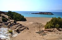 Sitia, East Crete at 34.5km (SE) Koufonisi is a small island in the Libyan Sea just off the South East coast of Crete and the Cape of Goudouras. It is also named LEFKI and gave its name to the municipality. There is a cluster of small islets in the area like Makroulo, Strogylo, Trahila and Marmara. The island is deserted and in many spots it is covered with sand reminding an African landscape. Until 1976 the shepherds used to feed their sheep there but it was not inhabited. Later the Archaeological Offices of Eastern Crete under the authority of N. Papadakis began the excavations and the island proved to be full of ancient sites. A beautiful theater, made of stones, at the North West end of the island opposite the Marmaras islet was discovered. At the South East of the theater where a settlement was found, a villa with 8 rooms and a guest room was brought to light. The excavations also showed a workshop where the famous purple robes of the Romans was made. They also dig out an astonishing building, the Public Baths, dated back to 1st and 4th A.D. and ruins of an old temple. Boats depart daily from Makrygialos to Koufonissi (during the tourist season and only if the weather permits) offering day-trips. A short description of Lefki, by the archaeologist Nikos Papadakis: Koufonisi island covered today with sand and bushes, lies close to the southeast shore of Crete. From the Middle - Ages until today is nowhere referred that the island has ever been inhabited permanently. However scattered ancient remnants, drew the attention of the English admiral and traveller T B. Spratt in the mid - 19th century. His itinerary and visit was repeated by the English archaeologists Bosanquet and Curely in 1903 and by the American A. Leonard jr in 1970. The definite conclusion all the above travellers reached was that Koufonisi could be identified with the island Lefki of antiquity for which the people of Itanos and Hierapytna were contending as it is referred in the famous "Inscription of Magnetes" of 112 - 111 B.C. Excavations and archaeological research have since 1976 taken the responsibility to answer to the questions almost innate and consequent to the above conclusion and the result is undoubtedly impressive: An entire theater that could have housed a thousand spectators: a temple still containing fragments from the colossal cult statue: two private houses with 17 rooms decorated with mosaics and colourful walls: a system supplying water to the city through a series of vaulted cisterns and built pipes: a Minoan acropolis: cemeteries and last but not least the city of Lefki itself. Thus, slowly but steadily is unveiled the short but impressive presence of this small island nearby east Crete. Judging from the so far finds we can say that Lefki being one of the major centers of processing and trading purple, a symbol of authority and economic power soon became the object of rivalry among its neighbours. A series of diplomatic intrigue and fighting had occurred over the dominance of this prolific island. Later when its sources of prosperity were depleted the people of Lefki were exterminated through arms and fire: an invasion in the 4th century A.D. turned the historic island into ashes. On the basis of the existing ruins the importance it had for its neighbours and the fact that it was never again inhabited after its destruction we may describe Koufonisi by quoting a western journalist as Delos of the Libyan Sea. 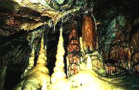 Zakros, Sitia, East Crete at 34.6km (E) The cave, with impressive stalagmites and stalactites, is located near the sea (~200m), at Pelekitá (GR: Πελεκητά), a place 3km away from the Palace of Zakros (~1 hour walk)and above the small bay of Karoumbi. In this cave were discovered signs of neolithic habitation. Its entrance is at 105m above sea, it is 310m long and its area is approximately 4.500m2. A little further there was found also the quarry from where the ancients took the stones to built their Palace (hence the name "Pelekita"). The cave is also known as "Sikias Spilios" (the fig tree's cave) due to the fig tree that is located at its entrance. The view to the sea from there is magnificent.
 Selinari, Vrahassi at 34.7km (W) Near the beautiful village of Vrahasi there is the imposing gorge of Selinari, formed by the mountain of Anavlohos (625 m) to the north and the mountain Fonias o Detis (818 m) to the south. The symbol of Crete, the Cretan wild goat (Agrimi or kri-kri) and the Griffon Vulture are two rare species that used to reside in the gorge. The authorities in Vrahasi intend to establish a center of protection of the local fauna and flora at the gorge of Selinari and to develop a wildlife station, to provide observation of the Griffon Vulture colony at the east side of the gorge of Selinari. The hunting is forbidden in an area covering 10 sq.km. around the gorge.  Mirabello, Lassithi at 34.9km (W) At the side of the gorge of Selinari, at the 42 km. of the national road Iraklion - Agios Nikolaos is the small old chapel and the newly founded monastery of Agios Georgios Selinaris. In the monastery there is also a home for the aged founded in 1963. The small chapel was probably founded early in the 16th century AD, and ever since it is a place of worshiping. The people passing through the chapel stop to light a candle to the saint. The chapel is considered miraculous, there are various legends concerning miracles related either with healing of sick people or with divine punishment of people that did not pay the respect due to the saint.
 Ierapetra, Lassithi at 35.2km (SW) Myrtos (GR: Μύρτος) is situated 15km to the west of Ierapetra, at the estuaries of the river Sarantapihos, in a valley with olive and orange trees. It is a beautiful village built by the sea, with a beach street lined with taverns and cafe bars. In a short distance from Myrtos on a low hill lies the archaeological site of "Pyrgos" with the ruins of a villa from the post minoan period and a little further at "Fournou Koryfi" lie the ruins of a proto minoan settlement. Myrtos features a small archaeological museum with exhibits mostly from the area, an initiative of a local teacher. Myrtos is a popular tourist destination, with nice small hotels, picturesque taverns and kafeneions, a lovely sandy beach and hospitable people. Image Library
 Ierapetra, Lassithi at 35.4km (SW) Mournies (GR: Μουρνιές - meaning: mulberry trees) is a village of the western Ierapetra. It is located north of Myrtos, and 25 kilometers away from Ierapetra at 275m (elevation), built on the southeastern outskirts of the Lasithi mountains, with beautiful views of the Libyan Sea and the plains of Ierapetra. It has a mild climate, without extremes, ideal both for permanent residence and for holidays. The landscape is hilly plenty of olive trees. In the 2001 census it had 83 residents. Mournies is a beautiful, historic, picturesque and traditional village with cafes, a square with a war memorial, an old fountain, and narrow streets branching off the main street of the village. Mournies was named after the Mulberry tree which however is not abundant in the area.  Ierapetra, Lassithi at 36.6km (SW) A small village built at an altitude of 540 m in the south parts of the mountain Dikti at the borders of the province of Ierapetra-Viannos. The imposing mountains above the village, the south horizon among the olive-covered hills and in the lower villages, the cool climate create in you a sensation of bodily and spiritual well-being at this balcony of the Cretan nature. Five settlements, two of them uninhabited today, constituted the Community of Riza, now a Local Department of the Municipality of Ierapetra.  Ierapetra, Lassithi at 36.7km (SW) A stately village built in settlements, 22 km away from Ierapetra, at an altitudeof 225 m, next to the Ierapetra-Vianos provincial road. A green landscape,overgrown with olive trees, with an unlimited view of the Libyan Sea, to thesurrounding areas Koleitos, Kakon Oros, to the beaches Vatos and Kallikovrechtis.An almost abandoned village, with old houses built of stone, with chiseled doorframes and coats of arms bearing the Christian cross and proving its old gloryand history.Giannis Dimitromanolakis, an author from Gdohia, writes:“Gdohia sprouted right opposite the beach of the Libyan Sea. Nothing wouldhave been better for the pirates, who, like diabolical ghosts, emerged into thenight to kill and prey. The village’s history is dipped in blood, as it often sufferedfrom the raids of the pirates from the Barbary Coast. It took the name Gdohiafrom the catastrophes, from the verb “gdyno”, to skin, to set fire, to devastate.”Gdohia’s course in time has evidence of struggles, sacrifices and holocausts toshow. It was not only exposed to the pirates but it was situated on the naturalsouth passage going from the Viannos area to the Ierapetra area. This meantthat the hordes of barbarous conquerors burnt and devastated it, along withthe other Symiana villages, as they are called, in the West Ierapetra.Gdohia’s settlements are built leaving a distance between each other: KatoGdohia or Pitropiana, taking their name from the Epitropakis family livingthere, Pefkiana or Grysboliana, from the Grysbolakis family, Dimitromanolianafrom the Dimitromanolakis family, Daskaliana from the Daskalakis family,Papadiana from the Papadakis family. Great stonecutters, stoneworkers,famous for their art, Gdohia’s residents built the mansions of the whole areaand the famous bridge of Myrtos using stones from the quarries of Kolleitos.The miraculous church of Panagia (Our Lady) Evaggelistria of Gdohia, a workof art and a great ecclesiastical monument is also built by Gdohia’s residents.Gdohia village, once the seat of a Community, today a Local Department ofthe Municipality of Ierapetra, presents an exceptional sight-seeing interest. Itprovides natural landscapes, beautiful beaches, picturesque little churches onthe hills, a spacious square with palm trees, seats and a war memorial forthe fallen fighters of the liberation wars. In the 1881 census, 296 residents areregistered and 73 in 2001. Gdohia’s permanent residents, along with someforeigners’ families who have bought and renovated old houses, struggle forthe village’s development which gradually acquires the necessary infrastructures.A village with rich history and civilization, with vast olive groves, a nicemild climate, both during summer and winter, it hopes to come back to life.The old mansions, half-wrecked and burned in the German Occupation, standas if they were sculptures, a painting with the deep blue Libyan Sea serving asa background, narrate the flourishing, the glory and the history of Gdohia andwait to be inhabited again.
 Mirabello, Lassithi at 37.7km (W) The village of Sissi, a picturesque village 40 km east of Heraklion and 25 km west of Ag. Nikolaos. Sissi is a beautiful fishing village with strange nature. On one side of the village the nature is wild, with a small river flowing into the sea, a number of palm trees on its banks, ducks and geese swimming peacefully. On the other side there are sandy and gravel beaches, caverns in the rocks and deep clear water, full of many kinds of fish. A place that gathers the nature of different places of Crete.
 by Richard Ellis at 38.4km (W) This was another delightful start to a day’s walking. Rather than tramping round the perimeter which is more or less where the E4 is supposed to go, it is quite possible to take a diagonal line from the south east corner to the north west corner by taking a right, then a left, then a right etc so you end up close to Kato Metochi. This way, you get to see close up the extent of the agricultural activity going on around the plateau in the morning sunshine. You also get to see the newly formed baby frogs – fresh from tadpole status – hopping happily in the sunshine in front of my big boots. Distance: 23.5 km Time: 7 hrs. Mov av 4.7 km/hr Height overnight: 335m.(max 824m.)  Ierapetra at 38.9km (SW) A picturesque uninhabited small island of cedar forest, tempting golden beaches and the well preserved old church of Agios Nikolaos, only 8 miles off the port of Ierapetra, to the south. From the middle of May to the end of October, there are daily boat cruises to Chrissi island, departing from Ierapetra and Makrygialos. There is a bar restaurant at the south beach and a beach bar at the northern beach also known as "Golden Beach". The island belongs to the NATURA network due to its rare combination of ecosystems which form the habitats of several endemic species.
Image Library
 Lassithi, Dikti Mountains at 39.1km (W) The Lassithi Plateau (GR: Οροπέδιο Λασιθίου, Oropedio Lasithiou), is a high endorheic plateau, located in eastern Crete, Greece on the mountain range of Dikti at an average altitude of 840 m, and in a distance of around 55km from Heraklion and 50km from Agios Nikolaos. The plateau is elliptical in shape with an E-W axis of 11km and the N-S of 7km. The plateau of Lassithi is renowned for its exceptional agricultural produce, the thousands (almost 15000) windmills that used to be there in the past, its significant historical role and for the unique cave of Psychro also known as "Diktaion Andron". Image Library
 Archaeological site in Malia, Iraklion at 39.3km (W) The Palace of Malia, which covered an area of 7,500 sq.m. , was the third- largest of the Minoan Palaces and is considered the most "provincial" from the architectural point of view. The first Palace was built in 1900 BC and destroyed in 1700 BC when a new Palace was built. Following the fate of the other palaces in Crete it was also destroyed in 1450 BC. and the present ruins are mainly those of the new palace.
 Pediada, Iraklion at 40km (W) Krassi is a small village 47 Km's from Iraklion and 17 km from Malia at an altitude of 600 m.asl, on the way to Lassithi plateau, and is administratively part of the Municipality of Malia. The village is one of the prettiest in Crete, with a lot of springs. Due to the free running water , it is covered with walnut trees, plane trees and all kinds of vegetation. Next to the spring in the middle of the village is one of the oldest and biggest plane trees in Crete (its root has a circumference of 22 meters!).  Seli Ampelou, Lassithi Plateau at 40.9km (W) It is the most significant group of windmills preserved on Crete. It occupies the northern entrance to the Lasithi plateau and is the landmark of the whole area. Today 24 windmills are preserved (out of the original 26), 7 of which extend to the south of the road that enters the plateau while the rest are built to the north of it. All the mills belong to the one-sided type of windmill, that grinds in a standard position, always on the same direction of the wind. Windmills of this type are preserved on Crete and on Carpathos but the Cretan ones are generally more carefully built and more elegant. The group of windmills has been declared a work of art since 1986. The mills belong to individuals and some of them have been restored while others still remain half-ruined. Source: The Hellenic Ministry of Culture |
||
|
| ||


C
O
N
T
E
N
T
S
O
N
T
E
N
T
S