interkriti®
YOUR GATEWAY TO CRETE
HOME
CRETE FACTS
NAVIGATE
EXPLORE

Agia Galini
Triopetra
Kissamos
Chryssi Isl.
Agia Marina
Balos
Gavdos isl.
Georgioupolis
SAMARIA
IDA Mtn
Palaiochora
Agia Roumeli
Sfakaki
Bali
Kalamaki
Matala
Lassithi
Plateau Lendas
Tsoutsouros
Vianos
Myrtos
Sfakia
Plakias
Ierapetra
Makrygialos
ZAKROS
Vai
Sitia
Agios Nikolaos
Elounda
MALIA
Hersonissos
Gouves
Chania
Rethymnon
Heraklion
GORTYN
FESTOS
KNOSSOS
|
|
Crete
List Grid Map
Found
123
- Showing :
61 - 80
 Pediada, Iraklion at 33.9km (W) Mathia is 11 km to the SE of Kasteli, has 215 inhabitants and lies at 590 m above sea level, in the foothills of the Afendi mountain (1578 m), with the Dikti mountain in the background. The earliest reference to the village can be found in several contracts of 1271 where the notary of Chandax P. Scardon mentions commercial exchanges of grain and wine with residents of the village ‘Mithie’, possibly a misspelling for Mathia. The name derives from the common first name for girls, ‘Mattia’, which in Crete is pronounced ‘Mathia’. Burials in jars of the middle Minoan period were discovered in 1957 close to the village, in a place known as Stavroplaka. To the NW of the village, at Katalimata, a Late Minoan site with important finds and, 200 m further off, a settlement with large walls still in place were also found.There are wonderful Byzantine wall paintings in the two churches of this traditional village, the church of Koimisi tis Panagias (Dormition of Our Lady) and the church of Agios Giorgos. At Metochi, in beautiful surroundings where the historical holm-oak of Ismail Pasha stands among plane trees and running water, there are camping facilities. You can also visit an old factory and several ruined mills. The village boasts of several kapheneions where they serve raki and ‘mezedes’ (tit-bits). There is an active cultural centre, that organizes events especially in the summer, with evenings of Cretan music and theatre plays. The most important and traditional feast is held on the Sunday of Agioi Pantes, 50 days after Easter. Image Library
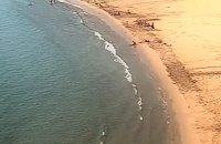 Sitia south at 34km (SE) A one kilometre long beach, with fine gold sand and shallow waters, lies right in front of the town of Makry Gialos. It is accredited with the blue flag and is considered to be one of the safest beaches for swimmers of all experience and children due to its soft and gently shelving. It is an organised beach with sun-beds, umbrellas and most sea sports facilities.  Pediada, Iraklion at 34.1km (W) Bizariano (GR: Μπιτζαριανό) is a traditional small village of about 24 inhabitants in the area of Kasteli Pediada, 320 m above sea level and about 3 km to the north of Kasteli on the road to Hersonissos. A pretty village with stone houses, graphic lanes and courtyards covered in flowers. It is first mentioned in 1881, as Bizariano, Municipality of Kasteli, with 55 Christian inhabitants. In 1951, it changes its name to Pigi. Its first name is that of a family, Bizariano. Close to the village, in a beautiful spot full of lush vegetation, evergreen plane trees and gushing water, stands the ancient church of Agios Pandeleimonas, with its three naves. Two rows of arches supported by columns without capitals separate the naves. Another column is made exclusively of capitals, apparently brought in from other churches or temples. Practically all the middle outside wall is decorated with inscriptions, Byzantine reliefs and crosses. Agios Panteleimon (External) Agios Panteleimon (External) Agios Panteleimon (interior) The artistic highlight of the church of Saint Panteleimon are its fresco scenes painted on the walls which are among the oldest in Crete, although very few frescoes remain. In the lower section of the arch, there is the representation of the three Hierarchs, shown on full length, with vertical inscriptions on it. On the two side walls there are the representations of Saints in a colossal size. These scenes were designed to be a source of biblical education to the faithful, who would have been illiterate at that time. Image Library
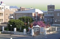 Sitia, Lassithi at 34.6km (E) The hospital provides full medical treatment and services. Website: www.ghsitia.gr Xerokamares, 72300 SitiaTel : 2843 3 40 100 FAX : 2843 0 25 352 - 2843 3 40 200 E-mail: ghsitia@ghsitia.gr  Gouves, Iraklion at 34.6km (W) At a height of 320 m above sea-level, Kalo Chorio (GR: Καλό Χωριό) λιεσ 25.7 kms. from Heraklion, to the right at the cross-roads at km 16.7 on the National Road to Agios Nikolaos and on the road to Gouves- Koxare- Kalo Chorio. The present name does not figure in old Venetian documents, though there is a reference in the 1367 Duke’s archives of Chandax to a Kalo Horio, without however naming the district. The villagers maintain that the village was called Stravorina in the old days, and indeed there is a reference by Barozzi in 1577 to a village Stravorina in the district of Pediados. In the 1583 Register, the village Stravorina is mentioned as having 76 inhabitants and in the Turkish census of 1671 Istavrine is quoted as having 21 "charatsa" (A Turkish word referring to a tax paid by the head of each family; hence 21 families). However, Chourmouzis Vizantios in 1842 mentions Kalo Chorio, the present name was therefore given in the decade 1830-1840. The village counted 298 inhabitants in 1981 which is also the current population. The Maza hill-top, south-east of the village, is 457 metres high. According to archaeologists (among them the famous N. Platon) and on the basis of recent finds, the name Maza comes from pre-Hellenic years and means Mother Earth. The pile of stones on the hill was, according to N.Platon, a town from the 10th to the 8th c. BC. The highest part was undoubtedly used as a shrine in Middle-Minoan years, and clay figurines and offerings were found there. The shrine lay quite close to the town. The shrine stopped being used in Proto-Geometric years. Northeast of the village, by the country road that leads from Kasteli to Hersonissos, traces of ancient installations have also been found along with remnants of water tanks by a source that is still in use today. These water tanks, probably belonged to Hersonissos aqueduct, parts of which are still visible today in Aposelemi valley. There is as well an interesting gorge close to Kalo Chorio, in the valley of Aposselemis river, worth seeing for nature lovers.  Pediada, Iraklion at 34.7km (W) Diavaide (GR: Διαβαϊδέ) has 120 inhabitants and lies very near to Kasteli (700m to the SE) at 355m above sea level. The earliest reference to the name is found in the Ducal Archives at Chandax in 1378. Another document in the same archives mentions a certain G. Dochiano, inhabitant of Diavaide. In an inscription, found in the Byzantine church of Agios Georgios Sfakiotis, the name of the village is clearly mentioned, indicating that Diavaide existed well before the Turkish occupation. In that church there is a unique fresco of Byzantine art that represents Saint George and Saint Demeter passing through the sea on their horses, while at their feet lie various sea creatures; crabs, lobsters, and other fish, a strange phenomenon indeed, considering that the village is so far away from the sea. There is also the church of Agios Nikolaos in the village dated to the same period. The village took part in all the main fights by Crete against the enemies of its freedom, while during German occupation the high college of Kastelli continued to operate in Diavaide houses. The cultural association of the village, one of the first in this area, strives to maintain the cultural traditions and the continuity of village history through the years.  Pediada, Iraklion at 34.8km (W) Polythéa (GR: Πολυθέα) is located 500 m NE of Kastelli at an altitude of 335m.N Nowadays Polythea has become part of Kasteli and it has 364 inhabitants. Fr. Barozzi mentions it as Apigaiduri in 1577, belonging to the Pediada district and it continues to be known with that name until 1940, when it is re-baptized with its current name, Polythea. The previous name of the village, Pigaidouri, is originated by the word ‘pigaidi', which is Cretan for ‘pigadi', which means ‘a well'. It is a nice name that propably has been changed due to the fact that people thought it was a reference to ‘gaidouri', which means ‘donkey'. Apart from the ubiquitous raki and mezedes served at the kapheneions, you can also find rooms for rent. A typical Cretan feast is held here on August 15th for the Virgin Mary (Assumption).  Pediada, Iraklion at 35km (W) To the east of Smari, at 400 m above sea level, with 99 inhabitants, Lagou (GR: Λαγού) is first mentioned in the Turkish census of 1671 with 4 haratsia (head tax). The journey to the village is charming getting you through areas of impressive wild landscape, and the typical old stone houses of Lagou, through the combined efforts of the members of the cultural centre, are being restored to their original traditional form so as to get the well deserved honour of being considered a protected traditional settlement. Image Library
 Sitia, East Lasssithi at 35.1km (E) The easternmost town in Crete. A small and pleasant coastal town, built in a semicircle on the western side of the Bay of Sitia (Si̱teía GR: Σητεία), a typical, peaceful Mediterranean port. It is the capital of the county with the same name and is sited 69 km east of Agios Nikolaos.
Image Library
 Sitia, East Lassithi at 35.1km (E) Piskokéfalo (GR: Πισκοκέφαλο), a principal village located 3 km south of Sitia. Piskokefalo is the birth place of the great poet Vincentzos Kornaros, who wrote the masterpiece of Medieval poetry, "Erotokritos". The village is mentioned at the census of 1577 by Fr. Barozzi, and became the seat of the commanding officer, after the destruction of the town of Sitia in 1538 by the pirate Chairentin Barbarossa. Nowadays Piskokefalo is a beautiful village where a stop is worthwhile. The visitor can see the house of Kornaros, enjoy a coffee or a meal at the village's square, visit the spring at Zou, the old water mill, the church of "Agia Anna" and the small chapel of "Panagia Trapezounta". 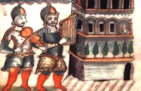 masterpiece of the Cretan Renaissance at 35.2km (E) Erotokritos (GR: Ερωτόκριτος) has been characterized as a masterpiece of the Greek language which unites the magic of myth and a deep understanding of everyday life. It expresses the "threefold ideal which is bravery, beauty and wisdom." A work rooted deeply in authentic Greek traditions, humanity, true feeling and pure love for life and freedom. The story takes place in Athens where King Herakles lives with his wife Artemis and their very beautiful daughter Aretousa, with whom the handsome and brave young man Erotokritos, son of the king's advisor, has fallen in love. After many difficulties and trials, the couple is married amidst celebrations and magnificent contests. The world of this work is the ideal Greek world of friendship, pure feelings, authentic Greek traditions. It is the world of the beauty of Athens and Crete which is "the throne of virtue and the river of wisdom." The language of this work is authentic Greek and Cretan, a synthesis and conscious effort of the poet to express lofty human feelings and values with simplicity, directness and truth. The poem was written by Vitsentzos Kornaros (1553-1613/14) a noble Cretan from Sitia with a very strong presence in Greek letters.  Cretan poet of the Greek Renaissance at 35.2km (E) Vitsentzos or Vikentios Kornáros (GR: Βιτσέντζος or Βικέντιος Κορνάρος) or Vincenzo Cornaro (March 29, 1553 – 1613/1614) was a Cretan poet of the Greek Renaissance who wrote the romantic epic poem Erotokritos. He was a leading figure of the Cretan Renaissance. Not many biographical sources exist about Kornaros himself apart from the last verses of Erotokritos. It is believed that he was born to a wealthy family in Trapezonda near Sitia, in 1553, and lived there roughly up to 1590. He then moved to Candia (present Iraklion), where he married to Marietta Zeno. Together they had two daughters named Helen and Katerina. Image Library
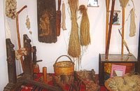 Sitia town at 35.3km (E) The Folklore Museum of Sitia (Siteia, GR: Σητεία) displays items from the 19th and early 20th centuries. It includes some unique embroidery, examples of traditional weaving, wood carvings, local dress and household items, all displayed in an authentic Sitian house setting. Address : 28, Kapetan Sifi Str., 72300 Sitia  Pediada, Iraklion at 35.3km (W) Kastelli (GR: Καστέλλι) is a small town in the countryside of the province of Pediada. It has over 2000 inhabitants and provides all the modern facilities and public services its residents and/or visitors may need. Many events are organized through the year by the municipality, the school and the cultural centre. In August a special festival, known as the Feast of Xenitemenou (ex-patriot feast) includes concerts, folklore, exhibitions and theatre plays.
 Pediada, Iraklion at 35.3km (W) Armacha (GR: Αρμάχα) lies at 490 m above sea level, at a distance of 7km from Kastelli, with 110 residents (census 2001) and is first referred to by Barozzi in 1577. Armacha is rich in the production of agricultural and livestock products. The Metropolitan Bishop, Tirnovos Voulgaria Ilarionas Kabanaris Sinitis was born, and is also buried here. A man of advanced learning, he wanted to translate the Bible to Demotic Greek.  by Richard Ellis at 35.3km (W) 9th June- I rested for a day in the Kalliopi hotel, tended to my feet as best I could and tried to “carb-load” as instructed by my tri-athlete daughter...I made the decision to take as direct a route as I could towards Profitis Ilias in order to make my rendez-vous with Triantafyllos at Rouvas the following evening. This meant leaving the official E4 and bypassing Archanes and Ghiouktas and all the interesting historical stuff. Distance: 38.5 km Time: 11.5 hrs. Mov av 5 km/hr Height overnight: 175m. 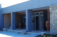 Sitia town at 35.4km (E) Rich displays cover the periods 3500 B.C to 500 A.D. The oldest artifacts come from the wider region of Sitia. The museum is divided into five chronological parts and displays include a valuable collection of vases, clay tablets in Linear A script which were found in the archives at Zakros, figurines from peak sanctuaries, a wine press from the neo-palatial period and a Hellenistic wheat mill. Of special interest is the ivory and gold male figurine which was found in Roussolakkos near Palekastro.
 Richard Ellis walk: Day 3 at 35.5km (SE) June 3rd - ...The short, direct, one marked with E4 signs ends in an olive grove with no way out ! You keep climbing on the basis that you will meet up with the Anavasi version of the route and then all of a sudden you find the dreaded stock fencing. I was lucky to find a way through (over) it, scramble up and over a ridge and see the easier, but longer, dirt road alternative on the other side of a full-flowing river. However, my choice of route seemed to be what the EOS expects you to do, as suddenly, and quite unexpectedly, there was another rare E4 sign on my side of the road on the way down to the river... Distance:24.7 km Time: 9 hrs. Mov av 4.3 km/hr Height overnight: 605m.(max 775 m.)  Pediada, Iraklion at 35.6km (W) Geraki (GR: Γεράκι). This lovely village of 375 inhabitants is located on the western slopes of the Lassithi mountains between the peaks of Afendi (1578 m) and Sarakinos (1588 m) in a beautiful glen, 520m above sea level and only 9km SE of Kastelli. It features an interesting Byzantine church, dedicated to the Archangel Michael (Archangelos Michail) with wall paintings that have not been maintained and some interesting (movable) icons by the local painter, Sepis. The active cultural centre of Geraki organizes many events during the summer season. Twice a year the village has a typical Cretan feast in honour of its patron saints: Agia Paraskevi on July 26th and Michail Archangelos on 8th November. The village produces agricultural products and great cheese that led to a specific cheese celebration. From Geraki you can also reach the lovely chapel of Agia Anna, driving through a particularly beautiful landscape with a spectacular view over the Geraki glen and fresh running water, a place ideal for a picnic. Image Library
 Pediada, Iraklion at 35.6km (W) Smari has a very long history and was inhabited, according to reliable sources, from the proto-Minoan period onwards. The archeological relics in the Akropolis of the hill called Profitis Elias, excavated under the direction of the Archeologist D. Hatzi Vallianou, indicate a continuous human presence from the Middle-Minoan period to about 630 B.C. |
||
|
| ||


)
)
)
';top.fotoWin('/dbsf/pages_pics/15/1522205/aposselemi_gorge01.jpg','');)
C
O
N
T
E
N
T
S
O
N
T
E
N
T
S