interkriti®
YOUR GATEWAY TO CRETE
HOME
CRETE FACTS
NAVIGATE
EXPLORE

Agia Galini
Triopetra
Kissamos
Chryssi Isl.
Agia Marina
Balos
Gavdos isl.
Georgioupolis
SAMARIA
IDA Mtn
Palaiochora
Agia Roumeli
Sfakaki
Bali
Kalamaki
Matala
Lassithi
Plateau Lendas
Tsoutsouros
Vianos
Myrtos
Sfakia
Plakias
Ierapetra
Makrygialos
ZAKROS
Vai
Sitia
Agios Nikolaos
Elounda
MALIA
Hersonissos
Gouves
Chania
Rethymnon
Heraklion
GORTYN
FESTOS
KNOSSOS
|
|
Crete
List Grid Map
Found
125
- Showing :
81 - 100
 Rethymnon North coast at 33km (E) Panormo is a small coastal village with ~400 inhabitants, located 25km east of Rethymnon in a small distance from the national road. The village has developed to a tourist resort providing quite a few tourist facilities such as hotels, apartments, lovely taverns and bars. There is also a small fishing harbour that serves mostly the locals. It is an nice place for swimming as its beaches - with umbrellas , sun beds etc - are with fine sand and clear water. Early-Christian basilica in Panormo In 1948 the archaeological axe brought to light the largest early-Christian basilica of Crete southwest of the village of Panormo. The basilica of Aghia Sofia had a wooden roof and dates back to the 5th century. About 25km from Panormo to the mainland is the archaeological site of Eleftherna. Image Library
 Kydonia,Chania at 33.1km (W) Within a few distance from the village of Perivolia, starts the gorgeous canyon of Therisso (Theriano faragi or Eleftherios Venizelos Gorge), which leads to the village of Therisso at 580m a.s.l. Six kilometers long, the gorge stretches like a snake, with high, almost vertical walls, and rich flora and fauna.It was a difficult to trespass gate, for the invaders, and that is the reason why Therisso was the center of the Cretan rebels during the 19th Century. The authorities has recently renamed the gorge, giving to it the name of the great Cretan statesman, Eleftherios Venizelos, who's name is strongly related with the area.  Sfakia, South Hania at 33.3km (SW) Ágios Pávlos (GR: Άγιος Παύλος)is a beach on the shores of Sfakiá between Agia Rouméli and Loutró. The pine trees from the high cliffs above almost reach the sea and form a unique landscape. The beach is sandy with pebbles with no facilities except for a small tavern. It can be reached only on foot ( about 1 hour walk from Agia Roumeli) or by boat. The picturesque small church of Agios Pavlos (Saint Paul) a byzantine basilica of the 10th century A.D. with frescoes, lies just a few meters from the sea. It is built with stones from the beach itself on the spot where Saint Paul reportedly baptised people on his way to Rome.
Image Library
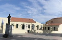 Chania at 33.3km (NW) The aim of the Foundation is to function on a national level as a dynamic european research and educational centre constituting a central point of reference for the coordination of research into the work, era and life of the great statesman and more generally into modern Greek history without ideological constraints and preconceptions and without local limitations. The address of the Foundation is: National Research Foundation "Eleftherios K. Venizelos" House of Eleftherios Venizelos Elena Venizelou Square, Chalepa, 731 33 Chania T.K. 73133 Tel. (0030) 28210-56008, 51555-6, 54011 Fax (0030) 28210-56009 Email: info@venizelos-foundation.gr Office Hours: 08:30 - 16:00 Website:www.venizelos-foundation.gr  Chania at 33.3km (NW) The village of Mournies is a principal village, located 3.8 km south of Hania at 40m a.s.l. It took the name "Mournies" from the numerous mulberry trees, that use to be here even today. At the beginning of the 17th century, Mournies was famous for its beautiful villas, belonging to local noblemen. One of them, located southeast of the village, was the imposing three storey villa of "Koukounara". It had beautiful flowery gardens, fountains, statues ..., a real paradise, where many famous persons were received hospitality, amongst them the glorious Mme Ortans, the empress Eugene of Napoleon the third, queen Olga of Greece, and the king Constantinos in 1913. The villa today, being restored, houses a department of the Geek Navy. Mournies was the birth place of one of the greatest statesman of the new Hellenic Republic, Eleftherios Venizelos. Venizelos' influence on the history of Greece was paramount, from his participation to the talks with the Ottomans that resulted to granting Crete independence in 1897, to the final union of Crete with Greece in 1913. The house of Venizelos located in Mournies is going to be a museum, and many personal items of the politician are going to be on display there.  Chalepa, Hania at 33.4km (NW) The Archaeological Museum of Chania is located in the historic suburb of Chalepa, on a plot of land covering 11,526.81 m2, with a total area of approximately 6,000 m2. Its location, averaging 98 m above sea level, offers a magnificent view over much of the city, especially the seafront. The Museum, designed by architect Theofanis Bobotis and partners, is composed of two distinct linear monolithic masses rising from the earth, a symbolic reference to the vestiges of civilisation beneath the surface. The permanent exhibition of the Archaeological Museum of Chania is set out in three galleries on the ground floor, presenting the archaeological riches of the regional unit of Chania from the first traces of human presence in Chania to the 4th century AD, and a gallery on the upper floor where part of the Konstantinos, Marika and Kyriakos Mitsotakis Collection is exhibited. The exhibition is enriched with faithful reconstructions of various spaces, visual media, digital presentations, tactile exhibits (copies of ancient objects) accompanied by Braille captions, and an audio guide. The Temporary Exhibition Gallery and the Museum gift shop are on the ground floor, while the Educational Programme Room, the Amphitheatre and the Café are on the upper floor. 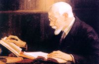 Politician born in Mournies, Chania at 33.4km (NW) Eleftherios Venizelos (Elefthérios Kyriákou Venizélos, GR: Ἐλευθέριος Κυριάκου Βενιζέλος - 23 August 1864 – 18 March 1936), born in Mournies village near Chania, was an eminent Greek revolutionary, a prominent and illustrious statesman as well as a charismatic leader in the early 20th century. Elected several times as Prime Minister of Greece and served from 1910 to 1920 and from 1928 to 1932. Venizelos had such profound influence on the internal and external affairs of Greece that he is credited with being "the maker of modern Greece", and he is still widely known as the "Ethnarch".
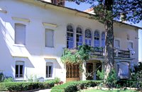 Halepa, Hania at 33.4km (NW) After the scientific and administrative services of the Foundation "Eleftherios Venizelos" were transferred to the former Vloom Mansion, in 2005, the Venizelos residence remained the Foundation's headquarters and it has been converted into a Museum, a commemoration site for Eleftherios Venizelos. The residence bears the imprint of Eleftherios Venizelos and the building has maintained its original form, of the years he lived there. The furniture of the decade 1925-1935 was selected by Venizelos himself and his wife Elena, and was brought from Athens and abroad. Decorative objects and paintings of the period, original photographs and personal items of significant value decorate the interior of the residence. Website:www.venizelos-foundation.gr  South Rethymnon at 33.7km (SE) The beach of Agios Pavlos is about 60 km from Rethymno and can be easily reached through an asphalt road. In fact, Agios Pavlos is a small settlement on a beautiful, picturesque cove. Around and close to the beach there are some small hotels and taverns and right on the beach a beautiful cafe / bar. West of the small settlement at a place known as Alatsogremni (Cliffs of salt) are the famous dunes of Agios Pavlos. Although dunes are not rare in the south coast of Crete, those are very impressive. High dunes that end in crystal clear, turquoise waters. A landscape of unique natural beauty that is worth seeing. The scenery is even more imposing late in the afternoon, when the sun is setting and the sand gets a golden hue. It looks like an image coming from another world. Between the small beach at Agios Pavlos and the Dunes we find the area of Apoplystra with the unique rock formations. From the beach of Agios Pavlos climb a wooden staircase and you are in front of a unique spectacle. Rocks sculpted by salt water, in various shapes and wonderful colors. 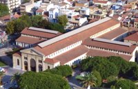 Hania town at 34.5km (NW) The Market, impressive for its size and shape, is built in the shape of a cross with 76 shops grouped according to their wares in the four arms of the cross. The south façade is particularly well constructed out of chiseled limestone, in the architectural style of the local tradition, developed during the Venetian period. Its construction was completed in 1913 and the formal opening was made by Eleftherios Venizelos on 4th December 1913 as part of the celebrations for the Unification of Crete to Greece.
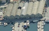 Hania, old port at 34.6km (NW) The south complex was completed in 1599, with the construction of 17 Neoria. Today only 7 survive out of the 17. In their original form they were open on the side of the sea. The ceilings are arched, and they are connected with arched openings of the same thickness as the walls.
 North West Crete at 34.7km (NW) Hania (or Chania GR: Χανιά) is the capital of the Prefecture of the same name and the second biggest town in Crete, with a population of 60.000 inhabitants. It lies (Coordinates 35°31' N 24°1' E ) along the North coast of the island, about 55 km west of Rethymnon and 140 km west of Iraklion (Heraklion). Hania's old town (although it was heavily bombed by Germans in World War II) is considered as Crete's most beautiful urban district, especially the Venetian harbour with its 16th century lighthouse and the Mosque of the Janissaries ("Giali Tzamissi", built 17th century). Many of the old buildings have been restored as hotels, restaurants, shops and bars, making the old town a lively and colourful place, especially during the tourist period.
 Samaria National Park at 34.7km (W) Pórtes (GR: Πόρτες - Gates) or Sideróportes (Iron Gates) is maybe the most striking point of the canyon. Here the canyon walls rise nearly 300 meters while the width is only 3.5 m. At this point the water runs almost all year round. The stratified limestone, the dominant rock of the canyon, forms specific geological formations, showing all the geological history of the canyon in the eyes of connoisseurs. Portes are 11 km away from the entrance of the Samarian gorge at Xylóskalo and 4km from the beach at Agia Roumeli.
Image Library
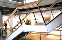 Hania old town at 34.7km (NW) An institution of culture, that aims in the creation of necessary "space", where the various sectors of Art, Science and Literature can coexist, each seeking the contribution of the other, thus becoming feasible the materialization of visions that each one of these means of expression of the Human spirit, to be able offer to the community. Address: 98-102, Chalidon Street, 73 131 Chania, Crete, Greece Phone number: +30 28210 92294 / +30 28210 36190 E-Mail: info@pinakothiki-chania.gr Links: Dimodiki Pinakothiki Hanion 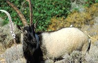 Cretan Ibex, Lefka Ori, Hania at 34.8km (W) Kri-Kri is the common name of the Cretan feral goat (Capra aegagrus ssp. cretica) which is the largest wild mammal on the island. Its grandeur, its bravery, its ability to observe without being noticed, its speed and its impressive horns are the features that were loved by the locals and made it a symbol of Crete and the untamed Cretan spirit. It lives mainly on the White Mountains and its local name is "Agrimi" (GR: Αγρίμι = the wild one) for the male and "Sanada" (GR: Σανάδα) for the female. Recent years, young kri-kris have approached the old village of Samaria, where they are fed by the park rangers and can be seen by the visitors. Kri-kris and goats are close genetically, as the hybridization that exists between them show. Kri-kri's size however is a good deal larger than that of a goat Kri-kris have a strong sexual dimorphism. Males are larger than females. They all have horns, with annual rings and knobs, from which their age can be easily calculated. Males have larger horns than females (up to 90 cm), which curve backwards. An other characteristic of the males is the beard, which rarely occurs in females. Their coat is short and brown in summer and brownish and denser in winter. They have a black line on the back, which extends from the neck to the top of the tail while at its shoulders the line intersects with another one that reaches the stomach. There are also black patterns on the front parts of their legs. There are numerous representations of Kri-kris on ancient sealstones, vases and coins, indicating the esteem in which they were held by the people of antiquity. Phototograph by Anastassios Sakoulis - www.photophysis.gr Image Library
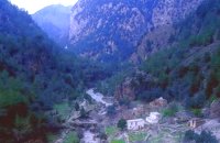 Samaria National Park at 34.8km (W) The deserted village of Samariá (GR: Σαμαριά) is located in the middle of the gorge of Samaria, 7.5 km away from Xyloskalo and 8.5km fro Agia Roumeli. This is the main resting point for the gorge walkers coming down from Omalos. There is a fountain with fresh drinkable water from the spring, benches and some tables, in the shade of tall plane trees where the visitors can relax and have some food (Only if they carry it with them). The village of Samaria was abandoned in 1962, when the area declared a National Park. The main occupations of its inhabitants were the wood cutting and bee keeping. Opposite the village are the old olive trees cultivated mainly for the residents' own consumption. Some of the village' s ruined housed are restored and are used today by the gorge authorities. One houses the guards' post, another the doctor's office and a third - the old olive mill - houses the information kiosk of the park where the visitors can view old pictures and folk art exhibits. Kri - kris (the Cetan Ibex) make their appearance here from time to time especially the young ones which are less shy. At the village's edge lies the byzantine church of "Osia Maria of Egypt" (Osia = Saint). The name Samaria is believed that is a corruption of the words "Osia Maria" or "Santa Maria". A little before the village (coming from Xyloskalo) in a small clearing lies the small church of Agios Geórgios. Image Library
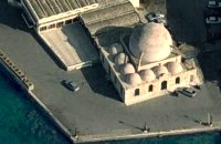 Venetian port, Chania at 34.9km (NW) The temple Kioutsouk (small) Hassan or Giali Tzamisi (seaside mosque), as it was commonly called, a brilliant sample of Islamic art of the Renaissance was a work of an Armenian architect, who had constructed another similar mosque in 'Spaniako', a village in the county of 'Selino'. The mosque, in the yard of which there were palm trees and graves of pashas and janissaries, stopped operating in 1923 and today it is restored without the small and picturesque minaret demolished in 1920.
 Sfakia, South Hania at 35.1km (W) The Samaria Gorge is one of the longest ravines in Europe (with a total length of 16 km) and offers one of the most spectacular hiking routes in Europe. Its width ranges from 150 m (widest part) to 3 m (narrowest part). The walk from Xyloskalo in the plateau of Omalos to the shores of Libyan sea at Agia Roumeli, takes 6 to 8 hours. The Samaria Gorge has been designated as a national park in order to protect its flora and fauna. It is one of the last shelters of the mountain goat of Crete (Cretan Ibex, common name : kri-kri). The flora is extensive, ranging from high cypress trees to flowers and herbs. The walking path follows the river which flows to small lakes and waterfalls. The Gorge is open to visitors from May to October. Image Library
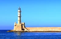 Hania harbour at 35.1km (NW) Chania lighthouse, the jewel of the city, is one of the oldest light houses, not only in Greece and the Mediterranean, but also in the world. The lighthouse (Faros GR: Φάρος) is a major attraction in the old port of Chania especially at night when it's lit up. The tower is 21m high and is built on a stone base, located at the end of the old harbour's pier opposite to the fortress of "Firkas". Visitors are not allowed to enter the tower. Chania lighthouse was first constructed by the Venetians around 1595 - 1601, and it took its final form, in the shape of a minaret, during the Egyptian Period (1831 - 1841) in around 1839. After the latest restoration, completed in 2006, it was given the formation of the Venetian period. The minaret look is still evident however. 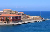 Hania harbour at 35.1km (NW) The fortress on the northwest side of the port was constructed to protect the entrance of the port and maintains its Turkish name "Firká" (Firka=barracks). A chain from "Firka" to the lighthouse blocked the entrance to the port in case of intrusion. The fortress was the headquarters of the Army Commander of the city. |
||
|
| ||


)
C
O
N
T
E
N
T
S
O
N
T
E
N
T
S