interkriti®
YOUR GATEWAY TO CRETE
HOME
CRETE FACTS
NAVIGATE
EXPLORE

Agia Galini
Triopetra
Kissamos
Chryssi Isl.
Agia Marina
Balos
Gavdos isl.
Georgioupolis
SAMARIA
IDA Mtn
Palaiochora
Agia Roumeli
Sfakaki
Bali
Kalamaki
Matala
Lassithi
Plateau Lendas
Tsoutsouros
Vianos
Myrtos
Sfakia
Plakias
Ierapetra
Makrygialos
ZAKROS
Vai
Sitia
Agios Nikolaos
Elounda
MALIA
Hersonissos
Gouves
Chania
Rethymnon
Heraklion
GORTYN
FESTOS
KNOSSOS
|
|
Crete
List Grid Map
Found
168
- Showing :
81 - 100
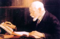
 Cretan Singer and lyra player from Anogeia at 37.7km (E) Nikos Xylouris (Greek: Νίκος Ξυλούρης, 7 July 1936 - 8 February 1980), nicknamed Psaronikos (Greek: Ψαρονίκος, "Grey Nick"), was a Greek composer lyra (Cretan lyre) player and singer from the town of Anogeia. He was part of the movement that brought down the Greek military Junta of 1967. His songs and music captured and described the Greek psyche and demeanor, gaining himself the title the archangel of Crete. Image Library
 Hania at 37.9km (NW) A guide to the area of Akrotiri. Tourist facilities, regional information and image gallery. Akrotiri with its scenic landscape provides a relaxing, refined country break away from the pressures of urban life. Its numerous monasteries, from the oldest in Crete, played a significant role in the history of the area. Gorges of outstanding beauty offer a unique hiking experience, breathtaking views and the joy of exploration...
Image Library
 Messara bay, Iraklion South at 39km (SE) Kokkinos Pirgos (GR: Κόκκινος Πύργος) is a small coastal community, 2km away from Timbaki with a nice, long sandy beach, one of the longest in Crete, and a clear transparent sea. The part of the beach to the north west of the harbour is called Makrimaliana (or Kakoskalo) and the south east part of it is called Katalyki . The harbour in front of the village of Kokkinos Pirgos, offers docking facilities for sailing and fishing boats. There are hotels, restaurants, bars, etc. across the harbour and along the beach. You can always find good fresh fish in the taverns of the village. Kokkinos Pirgos (meaning red tower) , took its name from a castle that use to be there during the Middle Ages, which was built by red clay earth.
Image Library
 Sfakia, South Hania at 39.3km (SW) Anopolis is a small village, built on a small but fertile plateau, 12 km west from Sfakia at 600 m above sea level. There are still traces of the ruins of the ancient city that prospered around the 3rd century BC, who's port was Phoenix (Loutro). Ancient Anopolis was one of the thirty city - states that signed the peace decree with Eumenes B’ in 183 BC. and thus was able to mint its own coins. During both the Venetian and the Turkish occupations, Anopolis was a center for revolutionary activities. It is the birth place of the freedom fighter Ioannis Daskalogiannis who's statue stands at the center of the village.There are three more small settlements, Limnia, Vigle and Pavliana on the same plateau. The mountainous landscape is of outstanding wild beauty. In the village there are rooms for rent and a tavern.The village is worth visiting not only for its natural beauty but also for the opportunity to explore the White Mountains. One of the best hikes is to descent to the shore through the ravine of Aradena, a five hour walk through an imposing ravine that ends up to the wonderful beach of Marmara.  Cretan hero born in Anopolis, Sfakia at 39.4km (SW) Daskalogiannis (GR: Δασκαλογιάννης) - born in Anopolis, Sfakia - started planning a revolutionary liberation movement in Crete in 1769 and completed the preparations for the revolution in Sfakia in the spring of 1770. In 1770, the revolution that had already broken out in other parts of Greece broke out in Crete too. Daskalogiannis, revolt was the first step towards freedom from the Turkish occupation in Crete and kept people, hopes from freedom alive. The international airport of Chania is named after this hero.
 Sfakia, South Hania at 40.8km (SW) Loutro is a small village halfway from Agia Roumeli, where the Samarian gorge ends, to Hora Sfakion, accessible only by boat. The majestic scenery, the calm, the crystal clear water and the hospitality of the local people gave Loutro numerous friends and ardent visitors. No cars, no bikes... nothing to spoil the peace of this historical place. Some small hotels, apartments and rooms as well as a few lovely taverns offer their guests a friendly atmosphere that makes Loutro an ideal place for vacation and relax.
 by Richard Ellis at 41km (W) 31th August - Katsiveli to Kallerghi via Pachnes- The day dawned with a cloudless blue sky. I was lucky. The route starts with a gentle two km warm up across the Niato plateau before turning more vicious. The next phase is a very steep 700 meter climb up the north east ridge of Kastro. One of the pluses is that you are doing this in the relative cool of the morning - one of the minuses is that you will probably be carrying something like five litres of water. Distance Total (with Pachnes climb): 25.3 km Time: 9 hrs. 30 mins. Mov av 3.3 km/hr Height overnight: 1,518m.(Kalergi) Max. height: 2,453m.(Pachnes) To Pachnes and back:12.1km, time 4hrs 10mins.  Messara Bay, Iraklion at 41.1km (S) Two small dry and uninhabited islets off the bay of Messara, ~7.5 naut. miles to the west of Matala. Due to their close proximity to one another the two islands appear as one from a distance. They are also called "elephantaki" as from north they look like a baby elephant that is lying down. In mythology it is believed that the goddess Lito gave birth to the god Apollon and the goddess Artemis on these islands. In antiquity they were called Dionissioi after the god Dionissos. During the summertime there are small cruising boats that bring tourists here from Agia Galini and Kokkinos Pyrgos. There is only a small beach with fine pebble and rich seabed at the south side of the easternmost islet. 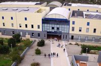 Akrotiri,Hania at 41.3km (NW) The Technical University of Crete, one of Greece’s Higher Education Institutions, which places emphasis both on education and research, was established in 1977 in Chania Crete and admitted its first students in October 1984. Today, the Technical University of Crete comprises 5 academic engineering departments, the Department of Production Engineering and Management, the Department of Mineral Resources Engineering, the Department of Electronic & Computer Engineering, the Department of Environmental Engineering and the Department of Architectural Engineering, assisted in their curriculum by the Sciences Department, all of which have set very high objectives. 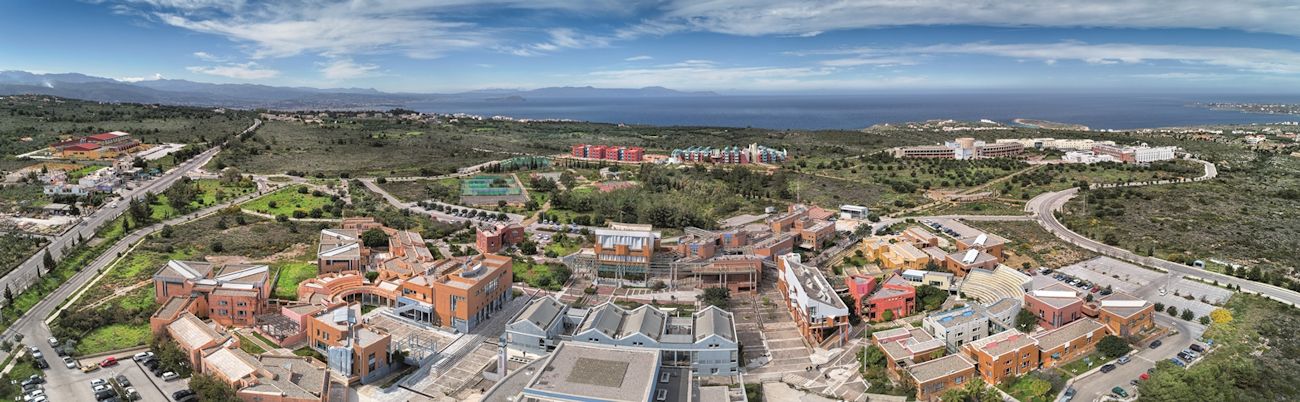 The Campus is built on a panoramic location in Kounoupidiana, Akrotiri, 7 km northeast of the city of Chania, with a total area surface of 290 hectares. Off campus, the Department of Architectural Engineering is located at the former French School in Halepa whereas the Rectorate and the rest of the administration offices are located in the heart of the old city of Chania in the Venetian complex of the old barracks and prison. Website (GR) :http://en.tuc.gr/contact-en.html Website (EN) :http://en.tuc.gr/contact-en.html Contact Information at:http://en.tuc.gr/contact-en.html  Idi mountain at 41.6km (SE) Located at the top (1750m) of Skinakas mountain of Idi (Ida) mounatin range, 60km from Heraklion. There are two telescopes and modern equipment and facilities both for research and educational activities in astronomy. It is a department of the University of Crete. Skinakas observatory offers a number of open days each year. This gives the opportunity to visitors to be introduced to the operation of the observatory, to get informed about the latest achievements in Astrophysics and to observe through the telescope. Open days for the year 2012: August 26 September 23 During the open days the Observatory facilities can be visited from 17:00 to 23:00. Due to low temperatures at the Skinakas altitude, warm clothes are highly recommended. The visitors will have the opportunity to be guided through the Observatory's infrastructure and follow a related presentation. The road to Skinakas Observatory is very narrow. Accident may occur and the space is limited on the top. For the reasons above, buses are not allowed (advised) to visit the Observatory during open days. Website : http://skinakas.physics.uoc.gr/  Hania at 41.6km (W) Institute dedicated to postgraduate and specialised education, applied research and the development of Mediterranean agriculture. MAICh offers postgraduate programs in the following fields: Business Economics and Management, Geoinformation in Environmental Management, Horticultural Genetics and Biotechnology, Food Quality and Chemistry of Natural Products and Sustainable Agriculture. 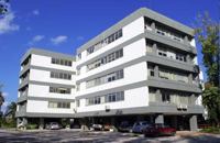 Hania at 41.8km (W) The Institute for Olive Tree and Subtropical Plants of Chania is one of the Institutes of the National Agricultural Research Foundation (NAGREF), located at Chania, Crete, Greece. The Institute consists of 10 Laboratories, with research activities focused on the following fields: Oliviculture and Post-harvest Physiology, Citriculture, Subtropical Plants, Irrigation and Water Resources Management, Plant Mineral Nutrition and Physiology, Entomology, Plant Pathology, Food Technology, Hydroponic Culture and Aromatic Plants, and Animal Production. The research activities of the Institute are supported by modern facilities, including fully equipped laboratories, glasshouses, 50 ha of experimental fields and collections of genetic material for olive, citrus, subtropical plants and grapevines.  Messara, Iraklion South at 41.9km (SE) The town of Timpaki (GR: Τυμπάκι) is located in the west edge of the plain of Messara, 65.3km away from the city of Iraklion. It is a rich and busy town with significant economic activity especially due to the early vegetables production in the wider area. There are banks, a post office, medical centers, stores, schools, hotels, restaurants, ect to cover both the needs of the locals and visitors.
 Akrotiri, Chania at 42.2km (NW) At the magical and historical location of Profitis Ilias, in Akrotiri, at the east of Hania lays the tomb of Eleftherios Venizelos, one of the most long-standing prime ministers of Greece and whose political life was focused on doubling the size of Greek territory and on the creation of a contemporary State. Eleftherios Venizelos himself had designated this position to be his resting place before his death. For the visitor, it affords a panoramic view of the rich green plain of Hania, the imposing White Mountains, the Cretan Sea, the town of Hania and the Chalepa quarter which is the location of the house in which the great politician spent most of his life and today is the headquarters of the National Research Foundation 'Eleftherios K. Venizelos'. Image Library
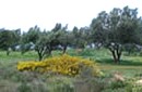 Akrotiri, Hania at 42.3km (NW) At a time that living organisms are disappearing at an alarming rate, especially through habitat destruction, the Park for the Preservation of Flora and Fauna of the Technical University of Crete, which extends to 30 hectares, constitutes a small but important area where native plants and co-existing animals are protected and can develop without human intervention. Up to now 250 different plant species that grow naturally in habitats of the Park have been identified, while their systematic documentation is still in progress. The development of new ecological units (“habitats”) began in areas of the Park that have been cultivated in the past. These will include plant species of Crete that do not grow naturally in the Park. Two such units, the wetland and the coastal habitats have already been launched. www.park.tuc.gr/  Painter born in Fodele, Iraklion at 42.7km (E) Great painter famous as "EL GRECO"(Fodele Iraklion Crete 1541 - Toledo Spain 1614) El Greco's art is the product of both his time and his genius. The artistic currents and the places he visited, are reflected in his work. It is more difficult to outline precisely the influence of the Cretan School in his work. Birth name: Doménikos Theotokópoulos (GR: Δομήνικος Θεοτοκόπουλος) Born :1541 Crete, then Republic of Venice Died :April 7, 1614 Toledo, Spain Field :Painting, sculpture and architecture Movement :Mannerism, Antinaturalism Famous works :El Espolio (1577–1579), The Assumption of the Virgin (1577–1579), The Burial of the Count of Orgaz (1586–1588), View of Toledo (1596–1600), Opening of the Fifth Seal (1608–1614).  Fodele, Iraklion, Crete at 42.7km (E) The museum is located at a place called "Archontiko", around 1000m west from Fodele village and is housed in the house where according to tradition the great painter Doménikos Theotokópoulos (El Greco), was born. The exhibits are mainly photo - reproductions of his paintings and other documents related to the painter's life and work. The house was severely damaged by the passage of time. The restoration began in 1982 with a grant from the Ministry of Culture and the considerable help of the then Minister Melina Mercouri, in collaboration with the community of Fodele. It was reconstructed according to its original design.  Voriza, South - West Iraklion at 42.9km (SE) Close historical bonds link this monastery to that of Vrontisiou. The Varsamonerou Monastery lies in the surrounding fields of the village Voriza, 54.5 kms from Heraklion. The monastery is abandoned and, though its cells have been destroyed, its church has some of the most remarkable wall paintings in Crete.
 Malevizi, North - West Iraklion at 43.2km (E) A traditional village - birth place of Domenikos Theotokopoulos (EL GRECO) - with many pottery and weaving workshops. Close to the village is a small beach with taverns and a large hotel resort. Fodele is known also for its quality orange production.
 Politician born in Mournies, Chania at 43.3km (NW) Eleftherios Venizelos (Elefthérios Kyriákou Venizélos, GR: Ἐλευθέριος Κυριάκου Βενιζέλος - 23 August 1864 – 18 March 1936), born in Mournies village near Chania, was an eminent Greek revolutionary, a prominent and illustrious statesman as well as a charismatic leader in the early 20th century. Elected several times as Prime Minister of Greece and served from 1910 to 1920 and from 1928 to 1932. Venizelos had such profound influence on the internal and external affairs of Greece that he is credited with being "the maker of modern Greece", and he is still widely known as the "Ethnarch".
|
||
|
| ||


C
O
N
T
E
N
T
S
O
N
T
E
N
T
S