interkriti®
YOUR GATEWAY TO CRETE
HOME
CRETE FACTS
NAVIGATE
EXPLORE

Agia Galini
Triopetra
Kissamos
Chryssi Isl.
Agia Marina
Balos
Gavdos isl.
Georgioupolis
SAMARIA
IDA Mtn
Palaiochora
Agia Roumeli
Sfakaki
Bali
Kalamaki
Matala
Lassithi
Plateau Lendas
Tsoutsouros
Vianos
Myrtos
Sfakia
Plakias
Ierapetra
Makrygialos
ZAKROS
Vai
Sitia
Agios Nikolaos
Elounda
MALIA
Hersonissos
Gouves
Chania
Rethymnon
Heraklion
GORTYN
FESTOS
KNOSSOS
|
|
Crete
List Grid Map
Found
152
- Showing :
101 - 120
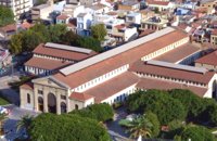 Hania town at 38.9km (NW) The Market, impressive for its size and shape, is built in the shape of a cross with 76 shops grouped according to their wares in the four arms of the cross. The south façade is particularly well constructed out of chiseled limestone, in the architectural style of the local tradition, developed during the Venetian period. Its construction was completed in 1913 and the formal opening was made by Eleftherios Venizelos on 4th December 1913 as part of the celebrations for the Unification of Crete to Greece.
 North West Crete at 39km (NW) Hania (or Chania GR: Χανιά) is the capital of the Prefecture of the same name and the second biggest town in Crete, with a population of 60.000 inhabitants. It lies (Coordinates 35°31' N 24°1' E ) along the North coast of the island, about 55 km west of Rethymnon and 140 km west of Iraklion (Heraklion). Hania's old town (although it was heavily bombed by Germans in World War II) is considered as Crete's most beautiful urban district, especially the Venetian harbour with its 16th century lighthouse and the Mosque of the Janissaries ("Giali Tzamissi", built 17th century). Many of the old buildings have been restored as hotels, restaurants, shops and bars, making the old town a lively and colourful place, especially during the tourist period.
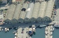 Hania, old port at 39km (NW) The south complex was completed in 1599, with the construction of 17 Neoria. Today only 7 survive out of the 17. In their original form they were open on the side of the sea. The ceilings are arched, and they are connected with arched openings of the same thickness as the walls.
 Hania old town at 39km (NW) An institution of culture, that aims in the creation of necessary "space", where the various sectors of Art, Science and Literature can coexist, each seeking the contribution of the other, thus becoming feasible the materialization of visions that each one of these means of expression of the Human spirit, to be able offer to the community. Address: 98-102, Chalidon Street, 73 131 Chania, Crete, Greece Phone number: +30 28210 92294 / +30 28210 36190 E-Mail: info@pinakothiki-chania.gr Links: Dimodiki Pinakothiki Hanion 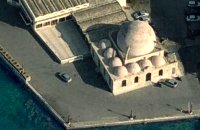 Venetian port, Chania at 39.2km (NW) The temple Kioutsouk (small) Hassan or Giali Tzamisi (seaside mosque), as it was commonly called, a brilliant sample of Islamic art of the Renaissance was a work of an Armenian architect, who had constructed another similar mosque in 'Spaniako', a village in the county of 'Selino'. The mosque, in the yard of which there were palm trees and graves of pashas and janissaries, stopped operating in 1923 and today it is restored without the small and picturesque minaret demolished in 1920.
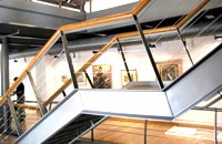
 Hania, Venetian port at 39.4km (NW) A two storey house, located at the old port of Hania, with a total area of 840 m2. The exhibition includes about 2,500 exhibits, such as models of ships, different kinds of naval instruments and devices, paintings, heirlooms, gleanings from the sea bottom, shells, photographs etc., which are divided in 13 units, covering chronologically all the periods. 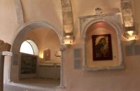 Hania, old town at 39.5km (NW) The wealth of archaeological material yielded by excavations conducted over many years by the 13th Ephorate of Byzantine Antiquities in the county of Chania, and also by retrieval of material and donations, forms a Collection that records, with great clarity, the history of the westernmost county in Crete from Early Christian times to the period of Turkish rule. Representative examples of this Collection are displayed in the church of San Salvatore. 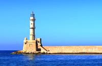 Hania harbour at 39.5km (NW) Chania lighthouse, the jewel of the city, is one of the oldest light houses, not only in Greece and the Mediterranean, but also in the world. The lighthouse (Faros GR: Φάρος) is a major attraction in the old port of Chania especially at night when it's lit up. The tower is 21m high and is built on a stone base, located at the end of the old harbour's pier opposite to the fortress of "Firkas". Visitors are not allowed to enter the tower. Chania lighthouse was first constructed by the Venetians around 1595 - 1601, and it took its final form, in the shape of a minaret, during the Egyptian Period (1831 - 1841) in around 1839. After the latest restoration, completed in 2006, it was given the formation of the Venetian period. The minaret look is still evident however. 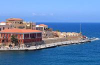 Hania harbour at 39.5km (NW) The fortress on the northwest side of the port was constructed to protect the entrance of the port and maintains its Turkish name "Firká" (Firka=barracks). A chain from "Firka" to the lighthouse blocked the entrance to the port in case of intrusion. The fortress was the headquarters of the Army Commander of the city.  Hania, old town at 39.5km (NW) The Franciscan monastery of San Salvatore, that houses the Byzantine and Post-Byzantine Collection of Chania, was built on the west side of the fortress of Chania, in three phases from the 15th century until the late Venetian period (middle of 17th century). The extensive restoration of the church made it possible to identify more clearly the various building phases of the monument, unify the space, and display its austere, uncluttered architectural features to good effect. The original church, which probably dates from the 15th century, was the small domed section on the east side.  Omalos, Hania at 39.7km (W) Xylóskalo (Ksyloskalo GR: Ξυλόσκαλο) is the point where the Samarian gorge starts. It is located on the Lefka Ori (White Mountains) in the plateau of Omalos, 43 km from the city of Hania at 1250m above sea level. It is also the entrance to the gorge. There are two tourist lodges where visitors can rest and have food or coffee and take panoramic pictures of the gorge and the White Mountains. There is also the information center of the National Park and a parking area. Xyloskalo means the "wooden stair" and refers to a wooden staircase built by the locals in order to facilitate the entrance to the gorge as at this point the cliffs are very steep. Today this part of the path is made of stones and it has a wooden handrail. About 1km before Xyloskalo a dirt road leads, after 5 km, to the Kallergis mountain lodge at 1680m a.s.l.  Rethymnon North coast at 40.9km (E) Bali is a small fishing village, about 40 km west of Iraklion and 37km east of Rethymno easily accessed from the international road. It has a small picturesque harbour and lots of small coves with wonderful clear beaches. Recent years Bali has been developed to a popular tourist resort but it is still preserves its traditional character. Ideal place for family holidays, with small hotels and lovely taverns serving fresh fish and local specialties.  The Venetians called the place "Atali", from its ancient name which was "Astali", while its current name was given by the Ottomans. There is also the Atali Monastery nearby, which retains the medieval name of the place and is dedicated to Saint John. The monastery is built on a small elevated peninsula overlooking the bay and the Cretan sea. Image Library
 Messara bay, Iraklion South at 41.8km (SE) Kokkinos Pirgos (GR: Κόκκινος Πύργος) is a small coastal community, 2km away from Timbaki with a nice, long sandy beach, one of the longest in Crete, and a clear transparent sea. The part of the beach to the north west of the harbour is called Makrimaliana (or Kakoskalo) and the south east part of it is called Katalyki . The harbour in front of the village of Kokkinos Pirgos, offers docking facilities for sailing and fishing boats. There are hotels, restaurants, bars, etc. across the harbour and along the beach. You can always find good fresh fish in the taverns of the village. Kokkinos Pirgos (meaning red tower) , took its name from a castle that use to be there during the Middle Ages, which was built by red clay earth.
Image Library
 White Mountains, Hania at 41.8km (W) The famous - mainly due to the gorge of Samaria- plateau of Omalos (GR: Ομαλός) is surrounded by the high crowns of the Lefka Ori (White Mountains) at 1,040 to 1,250 meters and is just 38 km from the town of Chania. It extends to the counties of Sfakia, Selino and Kydonia in the prefecture of Hania. Its shape is nearly rectangular with a perimeter of about 25kms and a diameter of approximately 4 kms. It can be reached by car from the north (Neratzoporo) and from the south (Agios Theodoros).
 Mylopotamos, Rethymno at 42.4km (E) Apladianá (GR: Απλαδιανά) is a small village built at the foot of the two Kouloukona heights. The settlement stretches out along the old national road, where it developed after the opening of the new national road. It comprises cafes, tavernas, and accommodation facilities included in the Countryside Tourism programs. It is worth your while, however, to visit the old village, climbing there on foot or by car. Picturesque, narrow streets, wonderful old houses with interesting architectural elements, old cisterns and churches will reward your efforts. The old village built on a height of 260 m above sea-level has 175 inhabitants and the settlement along the old national road, known as "Kampos ton Apladianon", has 78 inhabitants. It is 40 kilometres away from Rethymnon and is located at the foot of the highest peak of the Kouloukona mountain in the Tallaios range. Historical background Already as far back as 1368 we find a mention of the Aplada family, the founders of the present village and in the topographical maps of the Civil Engineering Services of Rethymnon it figures as Pladiana. The settlement is not mentioned in the 16th and 17th cent. documents. In the 1881 census, Apladiana is attributed to the commune of Garazo, with 57 inhabitants and in 1900 it is referred to as the Apladiana Commune which, together with the Cheliana settlement, had 153 inhabitants.  Psiloritis Mountain at 44.1km (E) At 1538m above sea level, 20 km. south of the traditional town of Anogia , on the plateau of Nida, of Mountain Psiloritis, lies this sacred cave, where according to mythology, Rhea, Zeus' mother, hid the new born Zeus in this cave in order to protect him from his father Kronos (Saturn), who was in the habit of swallowing his children because he feared they might deprive him of his power. Hidden in that cave Zeus grew up being fed with the milk of the goat Amalthia, while the 'Kourites" covered the child's crying through banging their copper shields. Image Library
 by Richard Ellis at 44.4km (E) 15th June- The path up to the summit of Psiloritis is well-known and well-marked and does not need any further description from me. Fortunately for me, my pack was lighter by about 4 kg as I had handed over my camping equipment and extra food supplies to T who was going to catch the ferry back from Chania two days later and who could drop my gear at the flat en route. Distance:20.1 km Time: 8 hrs. Mov av 3.2 km/hr Height overnight: 427m. Max. height:2,454 m  Messara, Iraklion South at 45km (SE) The town of Timpaki (GR: Τυμπάκι) is located in the west edge of the plain of Messara, 65.3km away from the city of Iraklion. It is a rich and busy town with significant economic activity especially due to the early vegetables production in the wider area. There are banks, a post office, medical centers, stores, schools, hotels, restaurants, ect to cover both the needs of the locals and visitors.
 Psiloritis Mountain at 45.3km (E) The plateau is located in the center of the Ida mountain range at an altitude of 1400 m. It can be accessed from various sides but the only asphalt road is from the town of Anogeia. It has a roughly triangular shape and is almost flat. Visitors can enjoy the wild landscape, take a walk to the entrance of Idaion cave or to the freedom fighter sculpture, made with boulders from the mountain. An other interesting attraction is the various Mitata scattered all over the area. Those are circular domed buildings made with stones and used by shepherds for accommodation and storage of cheese. There is also a tavern with traditional food. The area of Nida, in earlier times, before the systematic farming and logging damage the flora of Psiloritis, was covered by forests in which mythological and traditional tales put different events. Here Dimitra fell in love with the mortal Iasion. http://www.anogialand.gr  Anogia at 46.2km (E) The artistic events, which take place every year in the first week of July at the same place called Fourni and in the Cretan village of Anogia. The poet, songwriter and singer from Anogia, who they call "Loudovikos from Anogia" wants to make the history of the young martyr, who supersedes his fear in love known to the public. And because 1.900 years have passed since the martyrdom of Yakinthos, he decided to honor the Saint of Love and sing together with him of the poetry of love.(www.yakinthia.com)
|
||
|
| ||


C
O
N
T
E
N
T
S
O
N
T
E
N
T
S