interkriti®
YOUR GATEWAY TO CRETE
HOME
CRETE FACTS
NAVIGATE
EXPLORE

Agia Galini
Triopetra
Kissamos
Chryssi Isl.
Agia Marina
Balos
Gavdos isl.
Georgioupolis
SAMARIA
IDA Mtn
Palaiochora
Agia Roumeli
Sfakaki
Bali
Kalamaki
Matala
Lassithi
Plateau Lendas
Tsoutsouros
Vianos
Myrtos
Sfakia
Plakias
Ierapetra
Makrygialos
ZAKROS
Vai
Sitia
Agios Nikolaos
Elounda
MALIA
Hersonissos
Gouves
Chania
Rethymnon
Heraklion
GORTYN
FESTOS
KNOSSOS
|
|
Crete
List Grid Map
Found
207
- Showing :
141 - 160
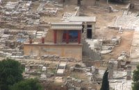
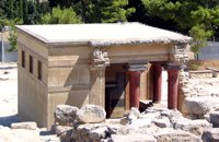
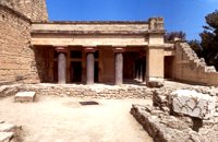 Knossos Palace at 45.2km (S) The "Hall of the Double Axes" was so named by Evans due to the double axe signs engraved on the walls of the light-well at its rear. He also thought that it was the place of residence of the King of Knossos. The central area has openings on three sides and is therefore called a "polythyron" (system with multiple doorways). It has a slab floor and its walls were embellished with gypsum slabs and frescoes. The area between the "polythyron" and the light-well was used as a reception hall. Traces of a wooden construction were found here. Evans reconstructed a wooden throne at this spot. Pictures: 1, 2 According to the archaeological finds, the arrangement of the apartments on the upper floor was similar to those on the ground floor. Image Library
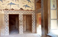 Knossos Palace at 45.2km (S) The Queen's Megaron lies in the Royal Apartments next to the "Hall of the Double Axes". It is a smaller room with a similar layout and rich decoration. Evans thought that it must have belonged to the Queen. Fragments of frescoes with dolphins and dancing ladies were found here. The room is largely restored and copies of the wall paintings have been put up on the walls. At the end of the room, a low partition wall with one column created a small space. It was thought that it was the "Queen's Bathroom" since pieces of a clay "bath" were found there. Pictures: The Queen's Hall 1, 2,3 A corridor joins the "Queens Megaron" with rooms that have been interpreted as places of preparation and washing. 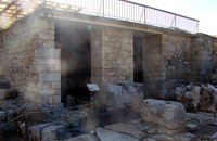 Knossos Palace at 45.2km (S) The magazine to the north of the Grand staircase took its name from the pithoi (large storage jars) that were found here. The jars have relief disk and rope decoration, a characteristic of the beginning of the New palace period (1700-1450 B.C.). A variety of finds show that the place had also been used as a magazine in the Old Palace period (1900-1700 B.C.). Next door is the "Corridor of the Bays", where three small openings were used for storage. Many vases and religious artefacts were found here. The magazines were buried at the end of the New Palace period(1700-1459 B.C.). Image Library
 Knossos Palace at 45.2km (S) Here is the so-called "School Room", an area where, according to Evans, scribes were taught to write on clay tablets. He supposed that they kneaded the clay in the built mortar next to the bench. It is more likely, however that it was a workshop for ceramics or wall-painting. Behind the "School Room" is the "Lapidary's Workshop", where blocks of crude or semi-worked lapis lacedaemoniae (spartan basalt) and stone tools were brought to light. According to Evans, the main workshop lay on the upper floor from which vases and large stone amphora had fallen to the ground floor. 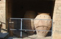 Knossos Palace at 45.3km (S) Here the excavators found a number of very large storage jars (Pithoi) and Evans named the place the "Magazines of the Giant Pithoi". These magazines are one of the older parts of the palace. The pithoi stand out for their size, the number of handles and the richness of their relief decoration with ropes and discs. To the right of the magazines a staircase which has been reconstructed by Evans descends to the east entrance of the Palace. The entrance is a robust construction that gives the impression of a "bastion". From this point it would have been easy to reach an important building of the palatial period, the so-called "Royal Villa" which lies outside the main archaeological site. Image Library
 Knossos Palace at 45.3km (S) The Royal Gaming Board was found here, a kind of board game made of ivory, rock crystal, Egyptian blue, silver and gold, now in Heraklion Museum. To the right of the corridor are the "Royal Pottery Stores", where Kamares pottery of the Old Palace period (1900-1700 B.C.) was uncovered, and to thee left, storage and workshop areas. Image Library
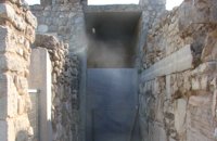
 Knossos Palace at 45.3km (S) An open air narrow passage linked the Central Court with the North Entrance. It was paved and had a strong inclination towards the north. Right and left were two raised colonnades known as "Bastions". Arthur Evans reconstructed the "Bastion" on the west side. He also placed a copy of a restored relief fresco of a bull here. The wall painting may have formed part of hunting scene. The passage ends in a large hall with ten square pillars and two columns. The pillars and columns probably supported a large hall on the upper floor. Evans suggested that, due to its position on the seaward side, it was here that the produce of seaborne trade would have been checked when it reached the Palace. It was therefore named the "Customs House". Image Library
 Knossos Palace at 45.3km (S) This room, located beside the north entrance, resembles a cistern. Its floor is lower than the surrounding area and is reached by steps. The "Lustral Basin" was surrounded by columns and was lined with slabs of gypsum giving it a luxurious appearance. In its present form, the area has been completely reconstructed by Evans. Areas with a similar arrangement have been found in other parts of the palace of Knossos, as well as other palaces and important Minoan buildings of the period (1700-1450 B.C.). It is not known how these places were used. However, from their construction it seems that theu would not have been filled with water, nor was there any drainage. Evans thought that they were used in purification ceremonies and therefore called these places "Lustral Basins". Evans also believed that the Palace was a sacred place. That is why, in his opinion, the "Lustral Basin"in question was used to purify visitors going into th Palace via neighbouring North Entrance. Image Library
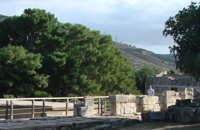
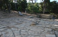 Knossos Palace at 45.3km (S) This area, sited at the north-west edge of the palace, was called the "Theatre" by Evans because its shape reminded him of later theatres. It is a platform and rows of steps that form a right angle. At the base of the stairs is the end of a narrow elevated road that crosses a paved court. Evans believed that the court was used for ceremonies watched by the standing viewers. The elevated paved road continues in the opposite direction. It passes underneath the modern road to Heraklion, connecting the Palace with the Minoan town, which extended to the West and North. Evans named the road the "Royal Road". Along the length of the road are town houses with workshops on the ground floor and residential areas on the upper floor. Image Library
 Iraklion at 45.4km (N) The TEI, located on the beautiful island of Crete, was founded in 1983 in order to provide Higher Technical Education to the students of Greece. Since then it has expanded and developed considerably, and now comprises the Schools of Applied Technology (also in Chania and Rethimno) Health & Welfare Services Management & Economics (also in Agio Nikolao and Ierapetra) and Agricultural Technology assisted by he Departments of General Sciences, Foreign Languages and Physical Education. Students at the TEI follow courses for 4 years including lectures and practical work in laboratories. In addition, they complete a work placement and dissertation before graduating. Education at the TEI offers up to date training in technological subjects and prepares students to develop into skilled, responsible and qualified members of society. With a permanent teaching staff of 200 and approximately 10.000 students the TEI of Heraklion is a thriving academic community with an extensive library, student halls of residence, sport facilities and a health center. P.O. Box 1939 IRAKLIO, Crete, Greece, GR 710 04 Tel: Fax: +30 281 0379328 http://www.teicrete.gr 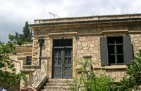 Knossos at 45.4km (S) Villa Ariadne was built at Knossos, Crete, by Sir Arthur Evans soon after he discovered the Minoan palace, when the site was his own private property. The villa became home, in turn, to John Pendlebury, who used it as a base for his excavations at Knossos and his explorations of the island. After Pendlebury's death at the hands of invading German paratroopers, the Villa Ariadne was taken over by General Karl Kreipe, who was living there when he was kidnapped by Patrick Leigh Fermor and his team. Ariadne villa is surrounded by the only existing Greek Edwardian garden, a large oasis of Cretan and other flora and shrubs in specific formations. The garden has been fully studied by the British School of Archaeology with the participation of special architects and agronomists from Heraklion. 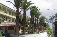 Knossou Av. Iraklion at 45.6km (NE) The General Hospital of Heraklion "Venizeleio & Pananio", named after the great statesman Eleftherios Venizelos, is one of the largest hospitals in Crete with 500 organic beds. It is located 4km away from Heraklion center on the road to Knossos, and occupies an area of 25,000 sq. meters. Venizeleio hospital provides high quality health services to citizens in a friendly and human environment. It was established in 1953 by a donation of Cretans of America and worked initially for Pulmonary Diseases. It was for many years the major hospital in East Crete. Telephone: (+30) 2813 408000 Website: www.venizeleio.gr/  Pediada, Iraklion at 45.9km (NE) Mathia is 11 km to the SE of Kasteli, has 215 inhabitants and lies at 590 m above sea level, in the foothills of the Afendi mountain (1578 m), with the Dikti mountain in the background. The earliest reference to the village can be found in several contracts of 1271 where the notary of Chandax P. Scardon mentions commercial exchanges of grain and wine with residents of the village ‘Mithie’, possibly a misspelling for Mathia. The name derives from the common first name for girls, ‘Mattia’, which in Crete is pronounced ‘Mathia’. Burials in jars of the middle Minoan period were discovered in 1957 close to the village, in a place known as Stavroplaka. To the NW of the village, at Katalimata, a Late Minoan site with important finds and, 200 m further off, a settlement with large walls still in place were also found.There are wonderful Byzantine wall paintings in the two churches of this traditional village, the church of Koimisi tis Panagias (Dormition of Our Lady) and the church of Agios Giorgos. At Metochi, in beautiful surroundings where the historical holm-oak of Ismail Pasha stands among plane trees and running water, there are camping facilities. You can also visit an old factory and several ruined mills. The village boasts of several kapheneions where they serve raki and ‘mezedes’ (tit-bits). There is an active cultural centre, that organizes events especially in the summer, with evenings of Cretan music and theatre plays. The most important and traditional feast is held on the Sunday of Agioi Pantes, 50 days after Easter. Image Library
 Pediada, Iraklion at 46.6km (NE) Kastelli (GR: Καστέλλι) is a small town in the countryside of the province of Pediada. It has over 2000 inhabitants and provides all the modern facilities and public services its residents and/or visitors may need. Many events are organized through the year by the municipality, the school and the cultural centre. In August a special festival, known as the Feast of Xenitemenou (ex-patriot feast) includes concerts, folklore, exhibitions and theatre plays.
 North - Central Crete at 46.7km (N) Iraklion (Heraklion or Herakleion GR: Ηράκλειον) is the largest urban centre in Crete, the capital of the region and the economic centre of the island. The first European civilisation, the Minoan civilisation, flourished on this land 5000 years ago. Currently the population of Iraklion is approximately 150.000 people. It is a very dynamic and cosmopolitan town, particularly during the summer period when thousands of visitors can be seen shopping in the market or visiting the museums and other places of interest. Today Heraklion is the top choice for tourist destinations in the Mediterranean. The city is also the commercial and scientific centre of the island. During the last 20 years the city has made remarkable progress in the academic and technological fields...
Image Library
 Malevizi, Iraklion at 46.7km (N) Dóxa (GR: Δόξα) is a pretty village built on a height of 400 metres above sea-level and 20 kilometres to the west of Heraklion on the road to the mountainous Milopotamos. The historical cave of Dóxa (GR: Δόξα) is located in a short distance from the village of Marathos on the road to Heraklion. It is at a height of 490 metres above sea-level, near a well-known taverna also called DOXA. The cave has a total length of 50 metres and impressive stalactites and stalagmites.  by Richard Ellis at 46.7km (NE) 9th June- I rested for a day in the Kalliopi hotel, tended to my feet as best I could and tried to “carb-load” as instructed by my tri-athlete daughter...I made the decision to take as direct a route as I could towards Profitis Ilias in order to make my rendez-vous with Triantafyllos at Rouvas the following evening. This meant leaving the official E4 and bypassing Archanes and Ghiouktas and all the interesting historical stuff. Distance: 38.5 km Time: 11.5 hrs. Mov av 5 km/hr Height overnight: 175m.  Amari, Rethymnon at 46.8km (NW) Sivritos (GR: Σίβρυτος) was an important and autonomous city of the ancient Crete. The city was built in the location that today is the village of Thronos. It was located on a hill dominating the valley of Amari. The name Sivritos is derived from the words si, that in the ancient eastern languages meant water, and the word vriti, that is of prehistoric origin and meant sweet. Therefore, Sivritos in the Minoan period meant sweet water. The derivation is also verified by the fact that near the hill where the city was located there are numerous sweet water springs.  Pediada, Iraklion at 46.8km (NE) Diavaide (GR: Διαβαϊδέ) has 120 inhabitants and lies very near to Kasteli (700m to the SE) at 355m above sea level. The earliest reference to the name is found in the Ducal Archives at Chandax in 1378. Another document in the same archives mentions a certain G. Dochiano, inhabitant of Diavaide. In an inscription, found in the Byzantine church of Agios Georgios Sfakiotis, the name of the village is clearly mentioned, indicating that Diavaide existed well before the Turkish occupation. In that church there is a unique fresco of Byzantine art that represents Saint George and Saint Demeter passing through the sea on their horses, while at their feet lie various sea creatures; crabs, lobsters, and other fish, a strange phenomenon indeed, considering that the village is so far away from the sea. There is also the church of Agios Nikolaos in the village dated to the same period. The village took part in all the main fights by Crete against the enemies of its freedom, while during German occupation the high college of Kastelli continued to operate in Diavaide houses. The cultural association of the village, one of the first in this area, strives to maintain the cultural traditions and the continuity of village history through the years.  Iraklion at 46.9km (N) Ammoudara (GR: Αμμουδάρα) is four kilometre long sandy beach that stretches from the west end of Heraklion to Linoperamata near the village of Gazi. The sand is fine and blond and extends several metres to the land and the sea is clear and safe. The predominant winds during the summertime are N, N-W usually "meltemi" that get more fresh at the western end of the beach, where the windsurf school is located. Along the shore there are hotels, some of them very large complexes, taverns, restaurants, bars, cafes etc that offer umbrellas and sun-beds on the beach. There are also lifeguards in some spots. The area in general is touristic and offers a full range of facilities, among them the modern multiplex "Technopolis" with cinema and an open-air theater. Image Library
|
||
|
| ||


;)
;)
;)
;)
;)
';top.fotoWin('/dbsf/pages_pics/15/1512321/giant_pithoi01.jpg');)
C
O
N
T
E
N
T
S
O
N
T
E
N
T
S