interkriti®
YOUR GATEWAY TO CRETE
HOME
CRETE FACTS
NAVIGATE
EXPLORE

Agia Galini
Triopetra
Kissamos
Chryssi Isl.
Agia Marina
Balos
Gavdos isl.
Georgioupolis
SAMARIA
IDA Mtn
Palaiochora
Agia Roumeli
Sfakaki
Bali
Kalamaki
Matala
Lassithi
Plateau Lendas
Tsoutsouros
Vianos
Myrtos
Sfakia
Plakias
Ierapetra
Makrygialos
ZAKROS
Vai
Sitia
Agios Nikolaos
Elounda
MALIA
Hersonissos
Gouves
Chania
Rethymnon
Heraklion
GORTYN
FESTOS
KNOSSOS
|
|
Crete
List Grid Map
Found
215
- Showing :
161 - 180
 Ierapetra town, South Lassithi at 33.8km (SE) The museum was founded at the end of the 19th century, during the Turkish occupation of Crete and was housed in several buildings in the past. Today it is housed in the building of the Commercial Ottoman School, which is protected by a preservation order. The collection includes findings from the broader area and from the Minoan to the Roman period. Among the items are painted sarcophagi, lamps, vases, figurines, relief plaques. One of the most important exhibits of the museum is the Clay sarcophagus dated to 1450-1400 B.C.
Image Library
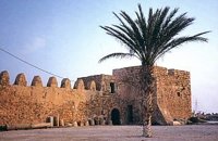 Ierapetra town, South Lassithi at 34km (SE) The fort, built by the Venetians and Known to Ierapetrans as the "Kalés" (GR: Καλές), has been erected on the top of the southernmost mole of the ancient harbour. It is one of those monuments of the past which, because of its solid construction and the fact that it was still garrisoned until the latest years of the last century, still exists today to serve as a reminder of some of the nation's most difficult times.
Image Library
 Iraklion at 34km (NW) Established in 1927, AGRUNION is one of the largest agricultural cooperative unions of Greece, with 167 members of 1st degree and over 47.000 members (farmers). Its range of products include olive oil, wines, vinegar and table grapes, sold into the Greek and foreign markets. They are produced in new-built factories equipped with foremost technological equipment, totally owned by AGRUNION.  Iraklion at 34.3km (W) The TEI, located on the beautiful island of Crete, was founded in 1983 in order to provide Higher Technical Education to the students of Greece. Since then it has expanded and developed considerably, and now comprises the Schools of Applied Technology (also in Chania and Rethimno) Health & Welfare Services Management & Economics (also in Agio Nikolao and Ierapetra) and Agricultural Technology assisted by he Departments of General Sciences, Foreign Languages and Physical Education. Students at the TEI follow courses for 4 years including lectures and practical work in laboratories. In addition, they complete a work placement and dissertation before graduating. Education at the TEI offers up to date training in technological subjects and prepares students to develop into skilled, responsible and qualified members of society. With a permanent teaching staff of 200 and approximately 10.000 students the TEI of Heraklion is a thriving academic community with an extensive library, student halls of residence, sport facilities and a health center. P.O. Box 1939 IRAKLIO, Crete, Greece, GR 710 04 Tel: Fax: +30 281 0379328 http://www.teicrete.gr  Iraklion north at 34.4km (NW) Dia (GR: Δία & Ντία) is an uninhabited island approximately 7 nautical miles north of Heraklion. It is surrounded by small rocky inlets and its maximum length is 5kms while its maximum width 3kms. Dia is one of NATURA's protected areas due to its status as a biotope for endemic plants and for plants with low dispersal within the Southern Aegean. Image Library
Vassiliki - Archaeological Site Pahia Ammos, Ierapetra at 34.5km (E) The ancient settlement of Vasilike is one of the first Minoan settlements with town-planning. It occupies the top and slopes of a low hill near the village Vasilike, in the vicinity of the Minoan settlement of Gournia. The first settlement dates back to the Early Minoan II period (2600-2300 B.C.) and owed its development not only to the strategic position, controlling the Isthmus of Hierapetra, but also to the neighbouring fertile plains. The central building of the settlement was destroyed by fire in around 2300 B.C.  Iraklion at 34.8km (NW) Capacity: 26,240 (seated)- Location: The stadium is located in Heraklion (also: Iraklio) 3 km west of the city centre (at Lido beach)... The building began 15 years ago and the 2004 Olympic Games proved to be the golden opportunity for the Pancretan, as the Athens Organising Committee named it as one of the venues of the football tournament. It was inaugurated on 31 March 2004, when it hosted an international friendly match between the National teams of Greece and Switzerland. The stadium is currently the second largest stadium of the country. The stadium is actually part of a sports complex. A training ground with an 8-lane athletics track, Lido Indoor Hall, and a swimming pool are located right next to the Pancretan Stadium. Image Library
 Stavrakia, Iraklion at 35.5km (W) The University Hospital of Heraklion (Pa.G.N.I.) is the largest hospital facility in Crete and one of the largest public hospitals in the country. The Pa.G.N.I. provides secondary and tertiary health care in a wide range of clinical specialties, diagnostic and laboratory tests. It is located 8km away from the city of Heraklion in the area of Stavrakia, next to the School of Medicine of the University of Crete Telephone: +30 2813 402111 & 2810 392111 Website: www.pagnh.gr/  Voutes Iraklion & Rethymno at 35.6km (W) The University of Crete, is multi-disciplinary, research- oriented Institution, situated in the cities of Rethymnon and Heraklion. It is a University with a well-known reputation both nationally and internationally, with state-of-the art curricula and graduate programmes, considerable research activity and initiatives that reflect its dynamic character. It was established in 1973 and operated during the academic year 1977-1978. Today, approximately 10628 students attend the University. The University's staff consists of 580 Teaching and Research Staff members. Its' operation is supported by more than 400 administrative staff.  Kenouriou, Iraklion at 35.9km (W) Doúli (GR: Δούλι) is a village in Kenouriou county, located 38 km from Iraklion at an altitude of 440 m above sea level. The earliest reference to it, is to be found in the Duke's Archives of 1372, where it is mentioned as the feudal property of Nic. Venerio. The name figures in all the Venetian censi of the 16th and 17th centuries, as well as in the Turkish (1671) and Egyptian (1834) censi. In 1881, Douli forms part of the municipality of Megali Vrisi with about 170 inhabitants, and again in 1900 with only 21 inhabitants. As of 1920, Douli is a commune in its own right, and today Douli has about 240 residents. The patron saint of the village is Aghios Panteleimonas and the feast of the Saint is celebrated on July 27th.A visit to the old church of Aghios Nikolaos is also a must. For those interested in paleontology, there are fossils to be found at the location 'Pirgos'.  Voutes, Iraklion at 36.4km (W) The Foundation for Research and Technology – Hellas (FORTH) is one of the largest research centers of Greece with well - organised facilities and a highly qualified staff. It functions under the supervision of the General Secretariat for Research and Technology of the Hellenic Ministry of Development and consists of seven Research Institutes, which are located in various regions of Greece: Heraklion, Rethymno, Patras and Ioannina. The Foundation’s headquarters, as well as the Central Administration offices are located in Heraklion, Crete.  Iraklion at 37.5km (NW) Ammoudara (GR: Αμμουδάρα) is four kilometre long sandy beach that stretches from the west end of Heraklion to Linoperamata near the village of Gazi. The sand is fine and blond and extends several metres to the land and the sea is clear and safe. The predominant winds during the summertime are N, N-W usually "meltemi" that get more fresh at the western end of the beach, where the windsurf school is located. Along the shore there are hotels, some of them very large complexes, taverns, restaurants, bars, cafes etc that offer umbrellas and sun-beds on the beach. There are also lifeguards in some spots. The area in general is touristic and offers a full range of facilities, among them the modern multiplex "Technopolis" with cinema and an open-air theater. Image Library
 Malevizi, Iraklion at 38.2km (W) Petrokéfalo (GR: Πετροκέφαλο) lies 16km from Iraklion and 3km from Agios Myron at 340m a.s.l with 248 inhabitants. It is built on a rocky hillside. The hill' shape resembles to a human head and it is supposed that the village owes its name to this (petrokefali = stone head) . The settlement was fortified and lately were discovered significant ancient findings. The patron Saint is "Agia Paraskevi" and there is a village feast on the 8th September in her honour.
 Kenourgiou, Iraklion at 38.7km (W) Agios Thomás (GR: Αγιος Θωμάς) lies at 530 m above sea level. It is 30 km away from Heraklion and has a panoramic view over the whole area to the SE of Aghia Varvara. Agios Thomas is a very old village and the first reference we have of it, is in a document of 1371, where it is quoted as a feudal property of Petrus de Medio, and again in a document dated 1380. Later, it figures in all the Venetian censi of the 16th and 17th centuries. In 1881, and in 1900, it figures as part of the Megali Vrisi municipality, with 344 inhabitants. From 1920, it figures in all the censi as a community with a continuously growing number of inhabitants. Nowadays there are over 800 inhabitants.  Malevizi, Iraklion at 38.8km (W) Agios Myron, with 708 inhabitants, lies 18 km from the city of Iraklion to the south west. Its one of the most important villages of the area with interesting town planning and impressive samples of traditional architecture. Built between two hills it commands a panoramic view and the school's clock, its main characteristic, is visible from almost everywhere in the area of Malevizi.  Malevizi, Iraklion at 39.2km (W) Pentamódi (GR: Πενταμόδι)one of the oldest villages in Crete, is located in the valley of Gazanos river, 17km from Iraklion and 4km from Agios Myron at 350m a.s.l with 278 inhabitants. At "Agia Paraskevi" a place with rich vegetation are organized every summer a series of cultural festivals. A fountain of the 15th century with the blazon of the house of "Quirini" is one of the significant monuments of the area. The patron Saint is "Agios Nikolaos" and there is a village feast on the 26th July in his honour.  Malevizi, Iraklion at 39.5km (W) Pyrgou lies 20 km from Iraklion and 1km from Agios Myron at 400m a.s.l with 354 inhabitants. It is built on a hillside overlooking the area, with panoramic view to the village of Kroussonas and the ravine of "Agia Irini". At the village's perimeter there are well maintained tower-like houses.  Kenouriou, Iraklion at 40.4km (W) Megali Vrissi (GR: Μεγάλη Βρύση) lies 32km south of Heraklion, at 620 m above sea level. In the Barozzi document of 1577, it is mentioned as forming part of the province of Monofatsi and, in the Archives of Megalo Kastro (Heraklion), it is quoted in 1583 as having 71 inhabitants; there is also a reference to the village in the Basilicata document of 1630. The Turkish census records it with 47 families in 1671, and in the Egyptian one in 1834, it figures with 27 families. In the censi of 1881 and 1900 it is mentioned as a municipality in its own right with, respectively, 240 inhabitants and 307 inhabitants. As of 1928, it becomes a commune and today it counts over 900 inhabitants. Saint Constantine is the patron saint of the village. The churches of Aghia Anna and of the Panagia Almiri are worth visiting. The Aeolian Park, one of the islands pioneering projects, has been installed in Megali Vrisi and produces electricity of 5MW.  Tylissos at 40.8km (W) The houses of Tylissos were built during the LM I period (16th-15th century B.C.). Additions were made on House A in the LM II (15th-14th century B.C.) and on House C during the LM III period (14th century B.C.). The site was destroyed by fire in the 14th century B.C. and re - inhabited in historic times as is attested by ruins of later houses over the Minoan ones. Tylissos was excavated by Joseph Chatzidakis in 1902-1913. In 1954, in the course of restorations, parts of a paved court were revealed to the west, and a small stoa with five columns to the north of the Square of the Altar. The monuments were restored by the Archaeological Service (under the direction of Nicolaos Platon) in the period between 1954 and 1962. All three houses were again restored in 1990-1994. Source: The Hellenic Ministry of Culture  Sitia, East Lassithi at 40.9km (E) A small picturesque village by the sea characterized as a landscape of exquisite, natural beauty. With joyful and peaceful inhabitants who constantly tease each other. It is located in Crete, north of Lasithi prefecture, between Agios Nikolaos and Sitia, at equal distance (30-35km) from the three major cities(Agios Nikolaos, Sitia, Ierapetra). Ideal place for holiday or special weekends. You will enjoy the most colourful sunset and the most beautiful daybreak from any other place. The serenity of the morning open view, with the sun rising from the sea, will be unforgettable. The small island, opposite the village, with the small church of Agios Nikolaos, offers a unique beauty to the landscape. |
||
|
| ||


)
)
)
)
)
)
)
C
O
N
T
E
N
T
S
O
N
T
E
N
T
S