interkriti®
YOUR GATEWAY TO CRETE
HOME
CRETE FACTS
NAVIGATE
EXPLORE

Agia Galini
Triopetra
Kissamos
Chryssi Isl.
Agia Marina
Balos
Gavdos isl.
Georgioupolis
SAMARIA
IDA Mtn
Palaiochora
Agia Roumeli
Sfakaki
Bali
Kalamaki
Matala
Lassithi
Plateau Lendas
Tsoutsouros
Vianos
Myrtos
Sfakia
Plakias
Ierapetra
Makrygialos
ZAKROS
Vai
Sitia
Agios Nikolaos
Elounda
MALIA
Hersonissos
Gouves
Chania
Rethymnon
Heraklion
GORTYN
FESTOS
KNOSSOS
|
|
Crete
List Grid Map
Found
250
- Showing :
161 - 180
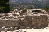
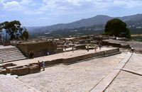 Phaistos Palace at 26.7km (SW) The main facade of both the Old and the New Palace looked onto the West Court, off which the official entrances to the Palace opened. The facade which can be seen on a lower level belongs to the Old Palace(1900- 1700 BC). It is indented according to the rules of Minoan architecture. The lower part of the walls is constructed of massive limestone blocks (orthostats). The entrance is set into a recess in the SW corner of the court. lt consisted of a monumental porch with a large central column from which a splendid corridor, paved with gypsum slabs, led to the Central Court. This old entrance is now interrupted by the buildings of the New Palace. Higher up and 7 metres further back is the facade of the New Palace (1700-1450 BC). It is constructed of large ashlars and also has deep indentations and protrusions. There are two entrances leading to the interior of the Palace. The main entrance is on the north and consists of a monumental staircase leading to the Propylaea. The other is deeply recesed and leads via a wide corridor to the Oentral Court, crossing the West Wing of the Palace 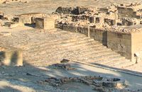 Phaistos Palace at 26.7km (SW) The impressive staircase starting in the west Court led to the monumental Propylaea, the principal and most impressive entrance to the New Palace (1700-M50 BC). The portico consists of a central column - only the base is preserved today - flanked by pilasters. There followed a solid wall with a double opening and a colonnade of three columns. The floors of the Propylaea complex were paved with gypsum slabs which gave it a sumptuous appearance. The colonnade opens onto a large open-air light-well through which rainwater drained away. There are two accesses from the Propylaea to different parts of the Palace. The first access, in the hall with the colonnade, led via a staircase and corridors to the Peristyle and thence to the "Royal Apartments". The second, in the SE corner of the light-well, led to an inner staircase which ended in the Antechamber of the Magazines and the Central Court of the Palace. Image Library
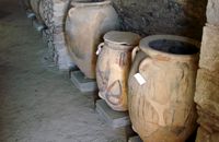
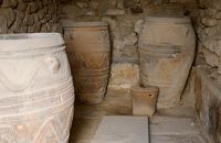 Phaistos Palace at 26.7km (SW) The magazines of the Old Palace(1900-1700 BC) occupied a large part of the West Wing immediately to the east of the West Court and extended to the lower terrace. Apart from their use as storage areas, they also appear to have housed some of the workshop activities of the Old Palace. Today most of the magazines have been filled in. One of these is the magazine with the giant pithoi (storage jars) decorated with discs and rope patterns in relief. Just east of this is a well-preserved quern installation for grinding grain. There is another well-preserved Old Palace magazine under the floor of the light-well in the Propylaea. 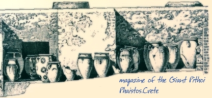 Image Library
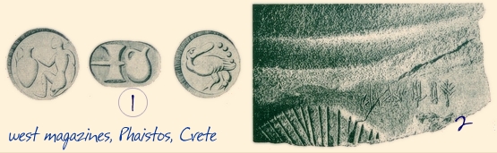
 Phaistos Palace at 26.7km (SW) The north part of the West Wing is occupied by she large complex of the palace magazines or store rooms. It consists of the antechamber, the corridor of the magazines and the magazines themselves. The first wide hall forms the antechamber of the magazines and opens off the Central Court via a doorway with a central column and two pillars. Two other columns inside the room supported the roof. Under the floor of the antechamber was discovered the Archive Room of the 0ld Palace (l900 - 1700 BC), containing over 6.000 clay sealings, i.e. seal impressions on balls of clay, which were used to monitor the movement of the goods in the magazines(fig 1). A double doorway with a central pillar on the west side of the antechamber led to the corridor of the magazines, with a second central pillar supporting the roof of the corridor. To right and left were the ll magazines, in which the goods produced by the Palace were stored. The westernmost magazine, on the north side of thecorridor, which has been roofed over by the excavators contains tall pithoi (storage jars), one of which bears an inscription in Linear A (fig.2)
Image Library
 Phaistos Palace at 26.7km (SW) Almost the whole south part of the West Wing was dedicated to the shrines of the New Palace. The main architectural types of shrine are the "Bench Shrine" and the "Lustral Basin". The first type consists of small, rectangular rooms with low benches running round the walls, perhaps to support cult objects and figurines of the deity. On some of them were found female figurines, ritual vessels and "Offering Tables" (small altars). On the walls of some rooms are incised sacred symbols, such as the double Axe and the star. The "lustral Basin" type consists of rooms which are set somewhat lower than the surrounding structures, with a few steps leading down into them. The were usually lined with slabs of gypsum, giving them a highly - finished appearance. Although it is doubtful that these structures contained water, it is thought that they were used for purification rituals. There is a third type of Minoan shrine in the S-E part of the shrine wing. Its is a room with central pillars (Square, stone - built columns) thought to be a cult area, similar to the "Pillar Crypts" of the Palace of Knossos, where the sacred pillar was worshiped by pouring libations. 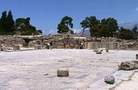 Phaistos Palace at 26.7km (SW) The great Central Court is a basic architectural element of Minoan palaces and the core around which the different wings are set. It was the focus of the economic, social and religious activity of the palace, the setting for events which could be watched from the windows and balconies. The Central Court of the Palace of Phaistos was built in the time of the Old Palace (1900-1700 BC). It was also used in the New Palace with minor alterations to its orientation and dimensions. It is a rectangular paved, open area with colonnades running along both its long sides, with alternating pillars and columns which supported open colonnades.On the west side of the court, two adjoining rectangular rooms with benches, open on to the Central Court, may have been "sitting rooms" for the spectators watching the events taking place in the Central Court. In the east colonnade of the court, some stone-built benches next to a water cistern may have formed islands of rest and recreation. The stepped structure in the NW corner of the court may have been an altar for the ceremonies which were held here. The pithoi (large storage jars) in front of it were found in buildings founded in the site of the Great Court after the destruction of the Palace. Image Library
 Amari, Rethymnon at 26.8km (W) The village of Apodoulou is located 55 km from Rethimno at an altitude of 450m. Remains of an extensive centre of the Old Palace period (1950-1700 B.C.) have been uncovered.at the site called Gournes, near the village of Apodoulou, at the west foot of Psiloreitis. The site dominates the Amari valley and controls the main route to the Messara plain. Excavations have brought to light three building complexes while tholos tombs of the Postpalatial period (1380-1200 B.C.) have also been located in the adjacent area. The first excavations on the site were carried out by S. Marinatos in the 1930's. During World War II it was excavated by the German Archaeological Institute, under the direction of E. Kirsten. Since 1985, systematic excavations have been carried out by the Greek Ministry of Culture in collaboration with the University of Naples. The most important monuments on the site are: Building A. It lies on the east side of the hill, to the south of the massive retaining wall. It had two storeys, as is indicated by the two preserved steps of a staircase. Decades of pithoi and other vases found on the ground floor suggest that it was used for storage. The house was destroyed by fire which followed an earthquake. Building B, located to the north of the retaining wall. It is a complex of rooms which originally communicated with Building A. Building C. It lies to the east of house A and belongs to a later phase of the settlement. Tholos tomb at Sopatakia. Tholos tomb with dromos, lying to the east of the road that leads from Apodoulou to Nithavris. The dromos is 7 m. long and the chamber has a diameter of 3.10 m. Three larnakes were found inside the burial chamber. Dated to 1380-1200 B.C. Source: The Hellenic Ministry of Culture  Found at Phaistos Palace at 26.8km (SW) The disc of Phaistos is the most important example of hieroglyphic inscription from Crete and was discovered around 1903-05 in a small room near the depositories of the "archive chamber", in the north - east apartments of the palace, together with a Linear A tablet and pottery dated to the beginning of the Neo-palatial period (1700- 1600 B.C.). The disc of Phaistos can be seen at the Archaeological Museum of Heraklion. Image Library
 Voritsi, Gouves at 26.9km (E) Kyra Eleoússa (GR: Κυρά Ελεούσα) Monastery is located close to the village Voroú or Voritsi. Due to its historical value the monastery and the outside area which covers 1000m has acquired protected status. Kyra Eleoussa is built according to feudal architectural style, and despite some interventions over the years it maintains many original architectural features. It is first referred in a document dating from 1606. At first it belonged to the monastery of Agia Ekaterini of Sinai but later it became part of Agarathos monastery.  Phaistos Palace at 27km (SW) The church of Agios Georgios (St. George GR: Αγιος Γεώργιος) Phalandras stands a little to the south from the Palace of Phaistos on the road to Agios Ioannis village. The church was the monastery church of the Orthodox male monastery of the same name, dated to the early Venetian period (16th century), which operated normally until its dissolution in 1821. The ruins of the fortified building complex around the church were still visible until the first decades of the 20th century. Image Library
 Gouves, Iraklion at 27.4km (E) At a height of 140m. above sea-level, this village has 142 inhabitants and is 22.5 kms away from Iraklion. According to the villagers, the name comes from the church of Aghios Nikolaos Skotino at the entrance of a cave. It was built at the end of the Venetian period. Today an extra wing has been added, dedicated to Aghios Charalambos. This church of Aghios Nikolaos Skotino presumably functioned as a "Hedge School" (or "Hidden School") under Turkish rule when education had been banned. When the locals said: "We are going to Skotino (which also means "darkness")", they meant they were going to school. Turkish administration refers to this place as Skotino Perasma in 1671. Very close to the village (1.5 km) the cave of Aghia Paraskevi draws crowds of tourists and is well worth a visit.  Archaeological Site in Messara, S-W Iraklion at 27.5km (SW) The "Royal Villa" at Ayia Triada which is situated very close to Phaistos, was built in about 1550 BC. i.e. just before the new palace at Phaistos, and was destroyed by fire in l450 BC, like all other important Minoan centres. It succeeded the first palace at Phaistos as the economic and administrative centre of the regions depriving the new palace there of this role, and appears to have had connections with Knossos. The two wings, with an open-air space between them, consisted of groups of interconnecting rooms (polythyra), storerooms and stairways. On the site of the ruins, a Mycenaean megaron, the so-called "Agora" and an open - air shrine were subsequently built. In the villa's disaster layer from the fire in 1450 BC, excavation revealed a valuable group of exceptional works of art, precious materials, records in Minoan script and seals. The famous black serpentine vessels, the "Harvesters' Vase", the "Boxers' Vase" and the "Chieftain ‘ s Cup", the wall paintings depicting the natural landscape, the sarcophagus, the bronze and clay figurines of worshipers and the copper ingots from the Treasury are among the most noteworthy findings.  Pediada, Iraklion at 27.5km (E) 330 m above sea level, just out of Kasteli (1.5 km) to the east, lies the village of Archangelos (GR: Αρχάγγελος) with 433 residents. It was founded in 961 by the military forces of Nikiphoros Phocas and was originally named ‘Varvaro’, and was still known by that name in 1583, where the Chandax Register puts it down as a village of the Pediada district with 37 inhabitants. Its name was changed only recently, in 1961, to Archangelos, and the main village church in the square is dedicated to the Archangel Michael. There is another smaller and older church, that of the Panaghia, with Byzantine wall paintings. Remains of ancient mills can still be seen. In a location known as Trochalos, archaeological finds have brought to light a series of Minoan tools dating back to the first and second Late Minoan periods. As in every Cretan village, raki and ‘mezedes’ are always available at the kapheneions. The feast of Michail Archangelos on November 8th is celebrated with much feasting in the village.  Pediada, Iraklion at 28.2km (E) Smari has a very long history and was inhabited, according to reliable sources, from the proto-Minoan period onwards. The archeological relics in the Akropolis of the hill called Profitis Elias, excavated under the direction of the Archeologist D. Hatzi Vallianou, indicate a continuous human presence from the Middle-Minoan period to about 630 B.C.  Messara, Iraklion South at 28.3km (SW) The town of Timpaki (GR: Τυμπάκι) is located in the west edge of the plain of Messara, 65.3km away from the city of Iraklion. It is a rich and busy town with significant economic activity especially due to the early vegetables production in the wider area. There are banks, a post office, medical centers, stores, schools, hotels, restaurants, ect to cover both the needs of the locals and visitors.
 Gouves, Iraklion at 28.3km (E) Pano Gouves (GR: Πάνω Γούβες) is a village of the district of Pediada in the prefecture of Iraklion at a height of 100 metres above sea-level. It lies twenty kms away from Iraklion, to the right at 17.3 kms on the National Road to Aghios Nikolaos. The village is built on the western flanks of the Ederi hill (322 m.). The name comes from "edera" which means ivy and symbolises affection. The name Gouves, on the other hand, comes from Gouva and means a hollow in the earth. It also means, in Crete, a hole in which during the middle ages, people stored their wheat. The earliest reference we have of the village is that of "Guves" in 1387 documents of the Duke’s archives in Chandax. Later on, in 1577, Fr. Barozzi mentions "Guvos" in the district of Pediados, and then "Guves" in the 1583 Register, with 252 inhabitants. Finally, in 1630, Vassilikata refers to "Vuves’. This is the birthplace of the poet Ioannis Konstantinidis. There are several outstanding churches in the village, among them: Zoodochos Pigis, Aghios Giorgos, Aghios Ioannis and Panayia (dedicated to the birth of Our Lady).  Pediada, Iraklion at 28.5km (E) At an altitude of 380m, with 63 inhabitants, Liliano (GR: Λιλιανό) is first mentioned in the Turkish census of 1671. The Basilica with its three naves, dedicated to Saint John, was built in the 12th -13th centuries and is one of the oldest and the most interesting in Crete. The stones used in its construction came from earlier buildings. The three naves, with the middle nave higher than the other two, are supported by columns in Ionic style. The narthex in front is lower with wider arches, whereas the door and windows have pointed arches.  Gouves Beach, North - East Iraklion at 28.8km (NE) Káto Goúves (GR: Κάτω Γούβες or simply Gouves) is a modern tourist resort with a complete tourist infrastructure to meet all demands. Organised beaches, large modern hotels, family apartments, restaurants, small tavernas, recreation centres, sports centre, shops, car and motorbikes for rent, small ports (marinas) for small boats, in a word Kato Gouves provides everything the visitors require to spend an agreeable and carefree holiday, enjoying the sunshine by day and the thrilling night-life in the numerous bars in the area. Just a few kilometers inland there are picturesque traditional villages, historic monasteries, caves and other natural beauties. Image Library
 Pediada, Iraklion at 28.8km (E) To the east of Smari, at 400 m above sea level, with 99 inhabitants, Lagou (GR: Λαγού) is first mentioned in the Turkish census of 1671 with 4 haratsia (head tax). The journey to the village is charming getting you through areas of impressive wild landscape, and the typical old stone houses of Lagou, through the combined efforts of the members of the cultural centre, are being restored to their original traditional form so as to get the well deserved honour of being considered a protected traditional settlement. Image Library
 by Richard Ellis at 28.8km (E) 9th June- I rested for a day in the Kalliopi hotel, tended to my feet as best I could and tried to “carb-load” as instructed by my tri-athlete daughter...I made the decision to take as direct a route as I could towards Profitis Ilias in order to make my rendez-vous with Triantafyllos at Rouvas the following evening. This meant leaving the official E4 and bypassing Archanes and Ghiouktas and all the interesting historical stuff. Distance: 38.5 km Time: 11.5 hrs. Mov av 5 km/hr Height overnight: 175m. |

|
||
|
| |||

C
O
N
T
E
N
T
S
O
N
T
E
N
T
S