interkriti®
YOUR GATEWAY TO CRETE
HOME
CRETE FACTS
NAVIGATE
EXPLORE

Agia Galini
Triopetra
Kissamos
Chryssi Isl.
Agia Marina
Balos
Gavdos isl.
Georgioupolis
SAMARIA
IDA Mtn
Palaiochora
Agia Roumeli
Sfakaki
Bali
Kalamaki
Matala
Lassithi
Plateau Lendas
Tsoutsouros
Vianos
Myrtos
Sfakia
Plakias
Ierapetra
Makrygialos
ZAKROS
Vai
Sitia
Agios Nikolaos
Elounda
MALIA
Hersonissos
Gouves
Chania
Rethymnon
Heraklion
GORTYN
FESTOS
KNOSSOS
|
|
Crete
List Grid Map
Found
62
- Showing :
41 - 60
Vassiliki - Archaeological Site Pahia Ammos, Ierapetra at 30.2km (SW) The ancient settlement of Vasilike is one of the first Minoan settlements with town-planning. It occupies the top and slopes of a low hill near the village Vasilike, in the vicinity of the Minoan settlement of Gournia. The first settlement dates back to the Early Minoan II period (2600-2300 B.C.) and owed its development not only to the strategic position, controlling the Isthmus of Hierapetra, but also to the neighbouring fertile plains. The central building of the settlement was destroyed by fire in around 2300 B.C. 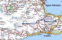 by Richard Ellis at 32.4km (SW) 5th June.- The GPS certainly gave me confidence whenever I came to junctions and occasionally the fairies who put up the E4 signs reassured me as well. If ever there was a “walk of the gods” it is here, as it contours round under Chalasmeni Korfi at over 1,000 metres and becomes steadily greener and more wooded. Distance:38.5 km Time: 11.5 hrs. Mov av 4.7 km/hr Height overnight: 887m.(max 1,100m.)  Elounda, Mirabello bay, Lassithi at 34.6km (W) The island of Spinalonga (Gr: Σπιναλόγκα), officially known as Kalydon (Καλυδών), is located in the Gulf of Elounda in north-eastern Crete, in Lasithi prefecture, next to the town of Elounda. The official Greek name of the island today is Kalydon. Originally, Spinalonga was not an island, it was part of the island of Crete. During Venetian occupation the island was carved out of the coast for defense purposes and a fort was built there. A popular name for the island since Venetian rule is Spinalonga. During Venetian rule, salt was harvested from salt pans around the island. The island has also been used as a leper colony. Spinalonga has appeared in novels, television series, and a short film.
 North East Crete, Lassithi at 34.9km (W) Agios Nikólaos (GR: Αγιος Νικόλαος), with 9.500 inhabitants, is the capital of the Lassithi province of Crete. It is built around a picturesque lake at the north-western side of the Mirabello bay, the biggest bay in Crete. Major administrative, cultural and communications center, Agios Nikolaos is one of the most developed tourist areas, not only in Crete but in Greece in general. Thanks to the beautiful coasts, the great sights and the cosmopolitan life, this lively city hosts every year thousands of visitors without losing one bit of its tranquility and traditional hospitality.
Image Library
 Agios Nikolaos, Lassithi at 34.9km (W) The Folk Art Museum of Aghios Nikolaos, in collaboration with the "Cultural Society of Eastern Crete", founded in 1978. All the original and important material was generously offered by the Touring Club of Aghios Nikolaos. Since then more objects have been added to the collection. A visit to the Folk Art Museum will help you to become familiar with the sort of work and activities the people of this area had in the old days. The Museum houses a rich and beautiful collection of hundreds of genuine samples of Cretan popular art and mainly hand woven and embroidered pieces, some of which are unique.  Mirabello Bay, Lassithi at 35km (W) The area is touristic developed with many shops, restaurants on the shore, bars and several excellent hotels famous for their comforts and the variety of amenities offered. The lagoon of Elounda is shaped between the coast and a small peninsula of 7-8 km length ... Spinalonga, since antiquity, has protected the harbor of ancient Olous.
 Agios Nikolaos, Lassithi at 35km (W) Lake Voulismeni (Gr: Λίμνη Βουλισμένη) or just "the Lake" for the locals, is located at the centre of the town of Agios Nikolaos. It has a circular shape of a diameter of 137 m and depth 64 m. The lake connects to the harbour of the town by a channel dug in 1870. A panoramic view of the lake can be seen from a small park situated above it. According to legend, the goddess Athena bathed in it. Every year at midnight turning to Orthodox Christian Easter day, the majority of the population of the town gathers around the lake to celebrate with fireworks, and firecrackers. It was reported that the German army during their withdrawal from the area at WW2, disposed parts of their weaponry and/or vehicles into the deep lake. A local urban legend has it that the lake is bottomless. That notion is potentially based on its impressively disproportional high depth compared to its width (64m depth on only 134m width) or/and on locals noticing disturbances at the surface or also the level of the water during the Santorini (Thera) earthquake of 1956. Because of the latter, many assume a possible geological relation of the two locations, but this claim has not been substantiated by known scientific surveys to date. Image Library
 Agios Nikolaos, Lassithi at 35km (W) Well protected Marina by all weather condition, build to European standards and capable to accommodating up to 255 boats all year round. The Marina of Aghios Nikolaos is located in the heart of the town, provides all the necessary facilities for a pleasant short or long stay for yacht passengers and a safe environment for the boats. Facilities: Water/Electricity:Each berth has access to a service box where fresh water and 220 / 380 volt electricity available.  Agios Nikolaos, Lassithi at 35.2km (W) The Archaeological Museum of Aghios Nikolaos is one of the most important in Crete and has been in operation since 1969. It houses collections of very important archaeological finds from the whole of Eastern Crete, an area extending from Malia as far as Zakros. These are displayed in chronological order from the Neolithic period (5700 - 2800 B.C.) to the end of the Roman times (100 B.C. - 400 A.D.) Its showcases include more than 1350 vases from the 3rd millennium B.C. as well as gold and copper finds (the most ancient found in Crete).
 Agios Nikolaos, Lassithi at 35.4km (W) Agios Nikolaos General Hospital (GR: Γενικό Νοσοκομείο Αγίου Νικολάου) is located in Agios Nikolaos in the prefecture of Lassithi. The St. Nicholas Hospital is a large modern hospital that provides full medical treatment and services to the population of the area since 1940.  Ierapetra, Lassithi at 38.1km (W) Between OLEROS and OLERIA there is the village Meseleroi, which took its name from the ancient OLEROS. It is situated at 10 km in the north of Ierapetra at an altitude of 360 m. Ancient Oleros flourished during the classical times, to be conquered by thepowerful Ierapytna. Oleria was a place of worship for Oleria Athena, with its famous statue, venerated by the residents of Oleria and Ierapytna.  Ierapetra, Lassithi at 38.6km (SW) It is a small village, 7 km to the north of Ierapetra, at an altitude of 212 m. According to tradition, the village took its name from a large olive tree. It produced at least 10 sacks of olives and it provoked admiration by its size, and mostly by its height (Makrylia meaning tall olive tree). The village is old and traditional, with original Cretan style houses that have remained untouched over the time, in a beautiful and healthy environment, with a view of the overgrown with olive trees plain, with a rich history and hospitable residents.  Ierapetra, Lassithi at 38.9km (SW) Ierápetra (GR: Ιεράπετρα), the southernmost town of Crete, combines a brilliant past with a present of economic growth and extension. The temperature seldom falls below 12°C, and the mean annual temperature is 20°C, also it is the sunniest and hottest region of Greece. It has a long sandy beach and clean blue sea, a picturesque port with the castle "Kales", an archaeological Museum, and many more attractions. Visitors will find a wide range of accommodation facilities and lots of interesting things to do and see in the town and the wider area as well.
Image Library
 Ierapetra town, South Lassithi at 39.8km (SW) The museum was founded at the end of the 19th century, during the Turkish occupation of Crete and was housed in several buildings in the past. Today it is housed in the building of the Commercial Ottoman School, which is protected by a preservation order. The collection includes findings from the broader area and from the Minoan to the Roman period. Among the items are painted sarcophagi, lamps, vases, figurines, relief plaques. One of the most important exhibits of the museum is the Clay sarcophagus dated to 1450-1400 B.C.
Image Library
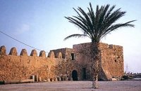 Ierapetra town, South Lassithi at 40.2km (SW) The fort, built by the Venetians and Known to Ierapetrans as the "Kalés" (GR: Καλές), has been erected on the top of the southernmost mole of the ancient harbour. It is one of those monuments of the past which, because of its solid construction and the fact that it was still garrisoned until the latest years of the last century, still exists today to serve as a reminder of some of the nation's most difficult times.
Image Library
 Mirabello, Lasstithi at 40.8km (W) Lato (Gr: Λατώ) was an ancient city of Crete, the ruins of which are located approximately 3 km from the small town of Kritsa. The Dorian city-state was built in a defensible position overlooking Mirabello Bay between two peaks, both of which became acropolises to the city. Although the city probably predates the arrival of the Dorians, the ruins date mainly from the Dorian period (fifth and fourth centuries BC). The city was destroyed ca. 200 BCE, but its port (Lato Etera or Lato pros Kamara), located near Agios Nikolaos was in use during Roman rule. There is some suggestion that the city was named after the goddess Leto (of which Lato is the usual Doric form) and may be mentioned in Linear B tablets as RA-TO. Lato also minted coins in antiquity,[3] bearing the likeness of the goddess Eileithyia who appears to have been the one particularly worshipped at Lato. Nearchus, admiral of Alexander the Great, was born at Lato.  Mirabello, Lasstithi at 41.2km (W) The Panagia Kera of Kritsa, as it is called the Temple of the Virgin Mary (Kera), is 1 km to the north of the village of Kritsa in Merabello Lassithi, in a place called Logari, right on the road from Agios Nikolaos to Kritsa. The history of the church of Panayia Kera begins at least since the 13th century.  Mirabello, Lasstithi at 41.8km (W) Kritsa is one of the most picturesque towns in Crete, built amphitheatrically on a rock hill. It is located 11 km from Agios Nikolaos and has 2000 inhabitants. The people keep the old Cretan customs and the traditions and the town is considered one of the most important centers of the Cretan folk and weaving art.
 Ierapetra, Lassithi at 43.1km (W) One of the most beautiful parts of the hinterland of Ierapetra is occupied by the picturesque village of Kalamafka. It is situated on the edge of the Lassithi mountains, an area known for its impressive diversity in landscape. Kalamafka sits at an altitude of 480 meters, 15 kilometers from the town of Ierapetra and 25 kilometers from Agios Nikolaos. Kalamafka is a picturesque, large, and prosperous village surrounded by unique natural beauty. The springs at Kefalovryso, with its plane trees and lush vegetation, as well as its old historical churches, gorges, and springs, attract visitors due to the oasis-like coolness it offers in this otherwise dry and hot region. The village's wealth lies in its water sources and the vitality of its residents, who resist urbanization. Another reason for Kalamafka's enduring population is its advantageous location, as it is centrally positioned between the north and south coasts of the island, drawing daily visitors from Ierapetra and Agios Nikolaos. History: The village derives its name from "Kali Afkla," a wooden channel that was once used to transfer water from one riverbank to another at the springs of Kefalovryso. Another explanation for the name is that the rock formation on Kastelos Hill resembles a Greek Orthodox priest's hat (kalymafki). Kalamafka, known as ancient Larisa, has been inhabited since the Minoan era. In the Psathi area, along the road to Ierapetra, archaeological findings such as human skulls, clay pots, spearheads, and various grave goods from the sub-Minoan era have been discovered. The geographer Strabo mentions Kalamafka, ancient Larisa, as follows: "And in Crete there is the city of Larisa, which now is united with Ierapytna, and from which the plain below, called Larision, takes its name." The god protector of ancient Larisa was Asclepius, and this is why the Medical Association of Lassithi has adopted the figure of a statuette discovered on the Kastelos peak, which overlooks the village and served as a peak sanctuary according to Mr. Michalis Pytikakis. Larisa was conquered around the 3rd century B.C. by Ierapytna, and its residents were relocated as per the terms of the treaty. Evidence from subsequent historical periods suggests that the Kalamafka area has been continuously inhabited due to the presence of the water sources of Kefalovryso. Place names like Kastelos, Mesokastela, and Larisakia attest to its historical significance. Kastelos Hill, serving as the seat of a feudal lord during the Venetian rule, had 435 residents in 1583. It boasted several notable Byzantine and post-Byzantine churches, along with numerous chapels. During the Turkish rule, it was a breeding ground for prominent chieftains like Nikolaos Foniadakis and Ioannis Baritakis. The village's history is marked by struggles and sacrifices that cannot be easily summarized. Today, Kalamafka is a vibrant village with a growing population. It has a two-seat school, a nursery school, a cultural association, numerous coffee houses, and seven taverns. The natural landscape, often referred to as "Chinese" due to its small rock pillars with bonsais, stone formations, and Kastelos Hill with its 224 steps, is considered a monument of natural history. Kalamafka offers visitors a wealth of attractions, including caves, rock paintings, the Havgas gorge, an ancient olive press, and the churches of Saint John and Saint Anthony. The taverns, shaded by plane trees and surrounded by running water, serve traditional and delicious local dishes, including the traditional "klostenios" halva and skyfomakarounes (local pasta). The sounds of the lyra, violin, and lute add to the ambiance, pleasing both locals and foreigners. There are indeed many compelling reasons to visit Kalamafka. By Toby Robert Image Library
 Mirabello, Lassithi at 45.3km (W) Neapolis is located 15 km westwards of Agios Nikolaos on the way to Heraklion from where it is roughly 50 km far. Neapolis is built in the green valley of Mirabello. In the period of the Venetian domination its two settlements were named "New Village". But when the seat of the Prefecture was transferred from Fourni to the “New Village” this last was renamed to Neapolis. Neapolis was maintained as the capital of the prefecture of Lasithi till 1904. After that date Agios Nikolaos became the new capital. |
||
|
| ||


C
O
N
T
E
N
T
S
O
N
T
E
N
T
S