interkriti®
YOUR GATEWAY TO CRETE
HOME
CRETE FACTS
NAVIGATE
EXPLORE

Agia Galini
Triopetra
Kissamos
Chryssi Isl.
Agia Marina
Balos
Gavdos isl.
Georgioupolis
SAMARIA
IDA Mtn
Palaiochora
Agia Roumeli
Sfakaki
Bali
Kalamaki
Matala
Lassithi
Plateau Lendas
Tsoutsouros
Vianos
Myrtos
Sfakia
Plakias
Ierapetra
Makrygialos
ZAKROS
Vai
Sitia
Agios Nikolaos
Elounda
MALIA
Hersonissos
Gouves
Chania
Rethymnon
Heraklion
GORTYN
FESTOS
KNOSSOS
|
|
Crete
List Grid Map
Found
149
- Showing :
41 - 60
 Seli Ampelou, Lassithi Plateau at 12km (SE) It is the most significant group of windmills preserved on Crete. It occupies the northern entrance to the Lasithi plateau and is the landmark of the whole area. Today 24 windmills are preserved (out of the original 26), 7 of which extend to the south of the road that enters the plateau while the rest are built to the north of it. All the mills belong to the one-sided type of windmill, that grinds in a standard position, always on the same direction of the wind. Windmills of this type are preserved on Crete and on Carpathos but the Cretan ones are generally more carefully built and more elegant. The group of windmills has been declared a work of art since 1986. The mills belong to individuals and some of them have been restored while others still remain half-ruined. Source: The Hellenic Ministry of Culture  Pediada, Iraklion at 12.1km (E) Krassi is a small village 47 Km's from Iraklion and 17 km from Malia at an altitude of 600 m.asl, on the way to Lassithi plateau, and is administratively part of the Municipality of Malia. The village is one of the prettiest in Crete, with a lot of springs. Due to the free running water , it is covered with walnut trees, plane trees and all kinds of vegetation. Next to the spring in the middle of the village is one of the oldest and biggest plane trees in Crete (its root has a circumference of 22 meters!).  Central Iraklion at 13km (SW) The town of Arkalochori (GR: Αρκαλοχώρι) with a population of 2.881 is located 33km away from Heraklion, on the provincial road linking Heraklion and Viannos, at 395m above sea level. Its inhabitants are mostly involved in agriculture, but in commerce and arts as well. Arkalochori is one of the most developing towns in the prefecture of Iraklion both in economic and cultural sectors and is the administrative center of the area. Events such as the Pancretan Agricultural and Commercial Exhibition, that takes place here are of great significance and interest for the whole island. The town offers a full range of modern facilities to its residents and visitors.
Image Library
 Arkalohori at 13.7km (SW) A modern exhibition and congressional centre offering 8000 square meters of total space, 1500 of them being indoors. Among many events that take place in this centre is the Pancretan Agricultural and Commercial Exhibition of Arkalochori held every two years at the end of August. The exhibition attracts a large number of enterprises, manufacturers and services participating and is being visited by over 30,000 visitors from all over Crete. It is considered to contribute essentially in the rapid commercial and cultural development of the wider area. Photo The Municipal Open Theatre Located in the area of the exhibition centre the theatre is of semicircular shape with a capacity of approximately 1000 seats. The facility offers also a canteen, toilets, dressing-rooms for the actors, store room of scene and backstage.The cultural events that the Municipality organises every summer, attract visitors not only from the wider area but also from Iraklion city. Photo Photo  Psychro, Lassithi Plateau at 14km (SE) The cave of Psychro is one of the most important cult places of Minoan Crete. The excavators and several scholars identify the cave as the famous "Diktaian Cave", where Zeus was born and brought up with the aid of Amaltheia and the Kouretes, and which is connected with myths as this of the seer Epimenides who "slept" here, or the coupling of Zeus with Europa.
 Archaeological site in Malia, Iraklion at 15km (E) The Palace of Malia, which covered an area of 7,500 sq.m. , was the third- largest of the Minoan Palaces and is considered the most "provincial" from the architectural point of view. The first Palace was built in 1900 BC and destroyed in 1700 BC when a new Palace was built. Following the fate of the other palaces in Crete it was also destroyed in 1450 BC. and the present ruins are mainly those of the new palace.
 Iraklion at 15.2km (NW) This 2 km long sandy beach was for years and still is the favorite beach of the people of Heraklion town. It is named after the river "Karteros" which outflows at the west end of it near the airport. The water is clean, the seabed is sandy with smoothly shelving and swimming is safe. The access is free in most parts except for some areas that are reserved for military personnel and the municipal beach "Akti" where visitors should pay an entrance fee in order to use the facilities. At the east end there are some very good taverns offering fresh fish among their specialties and are very popular with locals and tourists alike.
Image Library
 Archanes, Iraklion at 15.5km (W) A small traditional town (~4000 people) 15 km south of Iraklion on the foot of the sacred mountain Yiouhtas. Renowned for its excellent wine (from the varieties: vilana, kotsifali and madilari) and the archaeolocical sites and caves. In 1912, Xanthoudides noted the importance of Archanes, but Sir Arthur Evans was the first to characterize the site as palatial, declaring that Archanes was likely a Summer Palace for the Knossos kings. Spyridon Marinatos and N. Platon excavated minor areas in the region, but nothing supported Evans' theory. In 1964, J. Sakellarakis dug trial trenches at the Tourkoyeitonia site and uncovered the first evidence of a palace site. Since 1966, Archanes has been excavated by the Greek Archaeaological Society under the supervision of John Sakellarakis and Efi Sapouna-Sakellarakis. The small town of Epano Archanes, one of the most famous places of the Cretan land, with its colorful courtyards, teaches culture, taste, tradition, colors, aromas and life itself. The silvery grays of the olive groves, the red, pink, salmon and tiled walls, the blue and green shutters, the colorful bougainvillea boldly climbing the walls of the houses, the manicured flower beds, but also the elaborate, colorful signs in coffee shops and grocery stores. All this makes Archanes the most colorful village of Crete, but also of Greece. The town is full of atmospheric neighborhoods with well-maintained houses, painted in cheerful colors. At each step the visitor learns more and more about it. That's why the locals have taken care of it: the Folklore Museum, the Archaeological Museum, the sculpture workshop, the Museum of Cretan History and Tradition just outside. Image Library
 Houdetsi, Iraklion at 15.5km (SW) The Musical Workshop "Labyrinth" organizes seminars, concerts and various creative activities around modal traditional musics of the world. Labyrinth Musical Workshop was founded in 1982 by Ross Daly, with the goal of initiating young people, primarily, into a creative approach to traditional musical idioms from various parts of the world.  Lassithi, Dikti Mountains at 15.8km (SE) The Lassithi Plateau (GR: Οροπέδιο Λασιθίου, Oropedio Lasithiou), is a high endorheic plateau, located in eastern Crete, Greece on the mountain range of Dikti at an average altitude of 840 m, and in a distance of around 55km from Heraklion and 50km from Agios Nikolaos. The plateau is elliptical in shape with an E-W axis of 11km and the N-S of 7km. The plateau of Lassithi is renowned for its exceptional agricultural produce, the thousands (almost 15000) windmills that used to be there in the past, its significant historical role and for the unique cave of Psychro also known as "Diktaion Andron". Image Library
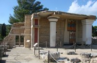
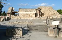
 Archanes at 16km (W) Excavations at Phourni have brought to light 26 buildings, most of which had funerary use. The cemetery was used from 2400 B.C. until 1200 B.C. and each complex had more than one architectural phase. Most of the funerary buildings were used for many decades and contain successive burials. Excavations were begun in 1964 by Efi and John Sakellarakis and have been continued until today (1995) with short interruptions. Most of the buildings are preserved in good condition.  Archanes at 16km (W) An excellent specimen of a specialized building, one of the first structures erected during the period of the Cretan State. It was designed by the architect Salivero, one of Prince George's officials. The plans were completed in 1901 and the construction was accomplished thanks to donations of rich Archanians living in the U.S.A. The building is Pi-shaped in plan, has two storeys and a basement, it is built of stone and its roof is partially wooden and covered with tiles. It is a monumental but well balanced structure with many harmonic and elegant Neoclassical features. Since its construction, the building has been used as a school. During the German occupation it housed General Muller's division. Source: The Hellenic Ministry of Culture  Archane, Iraklion at 16.1km (W) The Archaeological Museum of Archanes opened in 1993. It occupies an area of 570 square meters and it is located at the Tzami quarter in the center of the settlement. There, for the first time in Crete, the archaeological finds from a single site are exhibited. While the exterior spaces of the building were adapted to a tasteful ensemble, in resemblance with the impressive modesty of the environment and the traditional ochre and rosy colour tonations of Archanes. The interior was thus arranged as to accommodate the most modern mode of exhibition, especially attractive for the visitor.  by Richard Ellis at 16.3km (SE) This was another delightful start to a day’s walking. Rather than tramping round the perimeter which is more or less where the E4 is supposed to go, it is quite possible to take a diagonal line from the south east corner to the north west corner by taking a right, then a left, then a right etc so you end up close to Kato Metochi. This way, you get to see close up the extent of the agricultural activity going on around the plateau in the morning sunshine. You also get to see the newly formed baby frogs – fresh from tadpole status – hopping happily in the sunshine in front of my big boots. Distance: 23.5 km Time: 7 hrs. Mov av 4.7 km/hr Height overnight: 335m.(max 824m.)  Palace and Archaeological site at 16.4km (W) The famous Palace of king Minos and the centre of the Minoan civilisation 5km south of Iraklion. The Great Palace covered an area of 20.000 sq. meters and had 1.400 rooms. Every section of the Palace had a specific use. In the west side of the Palace were the chambers of the ceremonies, of the administration and of the public storehouse...
Image Library
 Knossos Palace at 16.4km (S) The "South Propylaeum", as we see it today, is a result of the restoration of Evans who put up a copy of the "Cup-Bearer" fresco here. The wall painting depicted a man holding a libation vase (rhyton). Its theme is connected with the "Procession Fresco" which, according to Evans, reached here, the "South Propylaeum". The pithoi (large storage jars) on the east side of the Propylaeum belong to the Postpalatial Period (1450-1100 B.C.), and indicate that the area was later used for storage.
Image Library
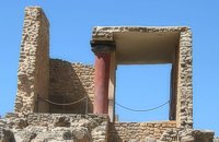 Knossos Palace at 16.4km (S) The south part and south facade of the palace is very eroded. Today one can only see foundations on tiered levels. At the bottom, a tower-like projection is all that remains of the south entrance to the Palace. An asceding corridor led to the Central Court. The section of the corridor closest to the Central Court was reconstructed by Evans who put here a copy of a relief wall painting, of which only few fragments were found. On these fragments, it was possible to make out a figure wearing jewellery in the shape of lilies. The reconstruction we see here is uncertain. In Evans's opinion, it represented the "Priest-King". Other scholars think that it is a prince, whilst others believe it depicts a female figure. Anyway the original fresco which is known as the "Prince of Lilies" is one of the masterpieces in the collection of the Heraklion Museum. Image Library
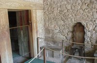 Knossos Palace at 16.4km (S) The antechamber of a complex of rooms that Evans named the "Throne Room". Its name comes from the stone seat found in the room behind the antechamber, and between them were discovered traces of a burnt wooden construction. Today, a wooden seat has been placed here which is a copy of the stone one in the neighbouring chamber. After the antechamber is the central room of the complex. Right and left of the stone seat are yet more stone benches. Pieces of fresco depicting plants and griffins, mythical beasts with a lion's body and bird's head were found in the same room. The restored fresco is in Heraklion Museum. Evans put a copy in its place. Stone vases for oil, often connected with rituals, were found on the floor. The stone basin you see was actually found in a neighbouring corridor and placed here. To the left, a low partition wall with a purification ceremonies and therefore called them "Lustral Basins". The central room connects at the back with a series of small, dark rooms which were lit by lamps, as the finds illustrate. The function of the complex is difficult to determine. Evans believed that the rooms were used for ceremonies with the main figure being the king of Knossos in his religious capacity. However, it seems unlikely to have been a Throne Room in the modern sense of the word. Image Library
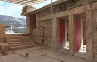 Knossos Palace at 16.4km (S) To the south of the Throne Room and the stairs, lies the area that has been identified as a shrine, called by Evans the "Tripartite Shrine" (Evans's restoration drawing). Its facade had columns and was divided into three parts, the central element being the highest. There is a depiction of a comparable shrine on a wall painting now on display in Heraklion Museum. Inside the shrine were found clay tablets in the Linear B script and clay seal impressions which were possibly connected with the archive of a shrine. The remaining areas behind the "Tripartite Shrine" are thought to have been connected with the sanctuaries of the palace. At the back, two small dark rooms with pillars are known as the "Pillar Crypts". The depresions in their floor are said to indicate that these rooms were used for libations. In another room, two large, rectangular, stone-built repositories were found, sunk into the floor. They were full of clay vases and valuable objects, amongst which were the statuettes representing the "Shake Goddess". The repositories have been interpreted as the "Temlple Repositories". The stairs on the right lead from the Central court to the upper floor of the West wing. This is largely reconstructed by Evans. Image Library
 Knossos Palace at 16.4km (S) The great staircase and the upper floor to which it leads are largely Evans’ creation. Evans thought that it had a function rather like the first floor of Italian Palazzi of the Renaissance, which was called Piano Nobile. In this instance, he considered that the important reception rooms of the palace would lie on the upper floor. Evans also thought that there existed a shrine, the "Tri-Columnar Shrine", and its Treasury. The basis for his restoration lies in the column and pillar bases and the ritual stone vases found collapsed onto the ground floor, like the alabaster one in the shape of a lioness head. The rectangular building next to the stairs was built a long time after the destruction of the palace. Evans interpreted it as a "Greek Temple" based on finds of the historic period.
Image Library
|
||
|
| ||


)
)
)
)
C
O
N
T
E
N
T
S
O
N
T
E
N
T
S