With a coastline of nearly 1046km, a mild Mediterranean climate, dozens of peaks over 2000 meters, unique cuisine and very hospitable people, Crete, the largest island in Greece, is undoubtedly a perfect place for mountain and water activities.
In this article I will try to describe my experience of sea kayak, through a two-day trip to the north of Chania as it took place in mid February 2012 with my friend Kostas and my wife.
It was a rainy Friday when we started to pack up things for the trip. Tent, sleeping bags, stove for cooking food and warm clothes, substrates and our rowing equipment was enough to fill his car and our mood for adventure. Our goal for this trip was the tour of Akrotiri. Akrotiri (a circular peninsula east of Chania) formerly called Kyamon while the Byzantines called the Haraka.
The whole journey (view map) we have to paddle is about 40 km, and is characterized by the absence of beaches for easy approaching and relaxing as well as exposure to the elements of the Cretan Sea.
According to Kostas experience (he has done a circumnavigation of Crete in the past, and dozens of other crossings in Greece and abroad) it is the hardest part of Crete, mainly for the reasons mentioned above.
The weather forecast for Saturday was to a maximum 3 Beaufort and Sunday for the most part we wanted to cross around 4 to 5 Beaufort in the afternoon.
With sea kayak is a rule not to ever start with 4 Beaufort unless the weather forecast shows that the wind will drop, especially if your knowledge of rescue techniques is missing. The Beaufort 4 in open sea or near rocky shores have nothing to do with what people see when they enjoy a swim in the sandy beaches of Crete.
Until recently sea kayaking training teams in Crete were almost nonexistent, making it almost impossible for someone to learn the sport.
For some time "enjoy-crete.com" provides a range of training courses, certified by the British Canoe Union (BCU).
Crossing the bay of Souda near the islet of Souda.
Late Friday we were erecting our tent in a small beach in the bay of Souda a few meters from the village of Kalami overlooking the islet of Souda.
On this small island there was originally just a church, that of St. Nicholas and much later, namely in 1571 AD, the Venetians built the fortress "Fortezza" in order to control the bay. When the Turks took Crete in 1669, they did not occupied the small fort, and so the islet of Souda was for some time a refuge for Cretan rebels until 1715 when it fell into Turkish hands.
On the left the island of rabbits overlooking the snowy White Mountains.
On the northwest side of the islet, a small distance away, there is another islet which is almost round in shape, which used to be referred to on medieval Venetian maps as Rabbit Island (known as Nisi and Leon today). In ancient times these two islets were referred to as Leukai (Greek for "white ones"). Their name came from the ancient Greek myth about a musical contest between the Sirens and the Muses. Out of their anguish from losing the competition, writes Stephanus of Byzantium, the Muses plucked their rivals' feathers from their wings; the Sirens turned white and fell into the sea at Aptera ("wingless") where they formed the islands in the bay that were called Lefkai.
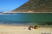
Passing the islands follows the only beach that you can find all the way down the first day. It is Marathi, a beautiful beach sheltered from the northerly winds of Crete.
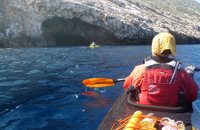
Impressive caves east of Cape
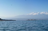
In the background the city of Chania and the White Mountains
From this point onwards and until Stavros there is no readily accessible beach to stop and rest. The landscape is so wild that reminds you distant lands. Hundreds of birds within a few meters overlook the kayaks and the deep blue of the Cretan Sea.
Impressive cliffs and caves accompany us for the rest of the way until we reach after about 6 hours, the village of Stavros. This village became known around the world from the film Zorba the Greek!
At the beach of Stavros we rested a little and then we set up the tent. A few hours later we left ourselves into the arms of Morpheus.
The first day was completed successfully. A total distance of 25 km with a wind maximum 3 Beaufort for several hours and a wonderful winter sun. Don't be fooled by the sunshine, because during the winter months at the unfortunate event of not heaving the right clothes on and the sea at 12-15°C hypothermia is the worst enemy of the paddler. The ideal clothing for the winter months consists of thin (3-5mm) neoprene pants or form plus a waterproof, breathable jacket. Particular emphasis should be put in shoes as fingers they do not move often and tend to become numb from the cold. An ideal solution is a pair of neoprene shoes and extra neoprene sock.
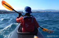
Early morning on Sunday and after a short breakfast, we headed to the sea in order to avoid the bad weather. Unfortunately it was no long after the Beaufort 4 hit us.
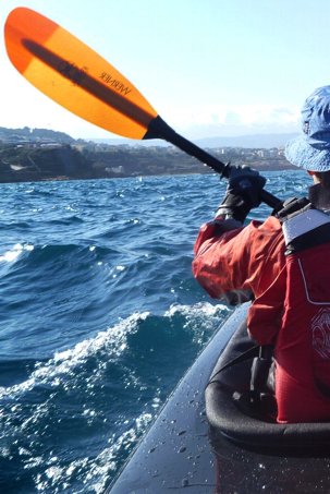
With sea kayak the most challenging wave is the one that comes from the side and that's what happened in our case! And while our initial plan was to go to the beach of Kalathas (about 1 + hours from the start) we were forced to change our course and made an open crossing to reduce the distance as the weather seemed to get even worse. The way that the tandem (this is how a double sea kayak called) was moving to the sea was very impressive, with half the kayak into the air from the waves, the whole experience was entirely different than the one we had the previous day.
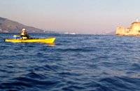
After about 3 hours our journey came to an end, reaching a small harbor, a little before the port of Chania, as we had planned for our arrival.
Stelios Asmargianakis of enjoy-crete.com


;)