interkriti®
YOUR GATEWAY TO CRETE
HOME
CRETE FACTS
NAVIGATE
EXPLORE

Agia Galini
Triopetra
Kissamos
Chryssi Isl.
Agia Marina
Balos
Gavdos isl.
Georgioupolis
SAMARIA
IDA Mtn
Palaiochora
Agia Roumeli
Sfakaki
Bali
Kalamaki
Matala
Lassithi
Plateau Lendas
Tsoutsouros
Vianos
Myrtos
Sfakia
Plakias
Ierapetra
Makrygialos
ZAKROS
Vai
Sitia
Agios Nikolaos
Elounda
MALIA
Hersonissos
Gouves
Chania
Rethymnon
Heraklion
GORTYN
FESTOS
KNOSSOS
|
|
Crete
:[u' Tourism & Leisure ']
List Grid Map
Found
567
- Showing :
341 - 360
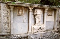 Iraklion It was made by "capitano" Gianmatteo Bembo between 1552-1554, it dominates in today's Kornarou square, next to a later Turkish philanthropic fountain. It is decorated with coats of arms and other elements of the renaissance and of gothic type, while in the middle a big headless statue stands out of the roman period. The spring is ornated with floral and embossed elements.
Image Library
 Sitia, East Crete The village of Tourloti (GR: Τουρλωτή) is located in Eastern Crete, on the road from Agios Nikolaos to Sitia. Tourloti is 42 km from Agios Nikolaos and 27 Km from Sitia. Tourloti is a small, traditional village, the largest of a group of four, dotted across the hillsides in this area. It has changed little in the past few decades, and remains untouched by tourism. However, it retains a healthy vibrant Greek community, of families living and working in the local area. The village has a prominent church, primary school, two small mini-markets, a bakery, chemist, post office, two kafenions and one small traditional taverna. The narrow streets with white washed houses, flower filled alleyways, and glimpses of spectacular views, give the village a unique, timeless sense of tranquility, far removed from modern city life. It is the centre for several religious celebrations and festivals, especially over Easter and the summer months. 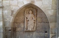 Iraklion Old Town It was made by Giovanni Sagredo between 1602-1604, part of it has been built in the Northwest corner of today's Loggia (Town Hall) and it is decorated with a carved female statue which according to Gerola's description probably with the left hand she was holding a shield, while with the right one a kind of a big hammer for display, representing the personification of Crete.
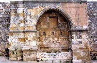
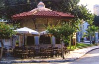 Kornarou square, Iraklion City It was built in 1776 by Hadji Ibrahim aga. In order to keep it working, he dedicated almost all his property. It is unique in its kind that is still preserved today. It is of a circular type building with a "tholos" and around the walls there are semi-circular windows with rails, in front of each one of them there exist a tap with a stone basin for the water to be collected. Today it is used as a coffeehouse.
Image Library
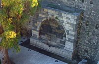 Iraklion Old Town It is next to the external Gate of St. George, underneath the statue of Eleutherios Venizelos. Within an arched construction, which its top is decorated with floral elements, there is a plaque and the spout is within a relief decorated frame. The water was collected in a marble basin of a similar decoration.
 Iraklion It is in the Ikarou Avenue, next to the Epigraphic Collection of Heraklion Museum. Within an arched construction which, is surrounded by two big square columns, decorated with rosettes, there is a relief spout of fine workmanship. The water is gathered in a marble basin adorned by a richly decorated relief. Image Library
 Sitia, East Crete The picturesque hilly village of Arméni (GR: Αρμένοι) is situated at the plateau of Ziros, 27 km from Sitia through Handra and 23 km through the villages of Papagianades and Etia. It was first recorded in a venetian census in 1583 with a population of 428. Today the village has approx. 400 inhabitants. The sightseer is impressed by the numerous windmills in the area. The church of Agia Sofia which used to be one of the most important churches of the Eastern Crete is also in Armeni. Amongst its icons, the Holy Mother presents interesting art features. The Cave of Holy Spirit is also in the area of the village of Armeni. In the wider area you can also visit the Etia settlement.  Sitia, East Crete Etiá (or Ethiá GR: Ετιά) is a small settlement situated 2 klm away from the village of Papagianades driving to the village of Armeni. In a Venetian census was recorded with a population of 564. The village of Etia was at peak of its power around the Venetian occupation and from the presence of the St. John and St. Aikaterini churches one assumes that the village also existed through the Byzantine period as well. The village used to be private property of the De Mezzo family, a venetian family, where they built their three-storeyed house, the Seragio Serai House, which used to host Turkish officers as well during the Turkish occupation and can be seen nowadays. This House is considered to be one of the most important samples of the Venetian architecture in Crete. The church of St. Aikaterini used to be occupied by the Turks as a mosque until the Cretan revolution in 1897. At the south of village of Etia there is the hill of Etiani Kefala at an altitude of 715 m. where it used to be a sacred place but unfortunately nowadays looted.  Sitia, East Crete The Agia Triáda (Holy Trinity GR: Αγία Τριάδα)) Community is 35 km from the town of Sitia at the end of the plateau of Ziros, with a population of 156. Long ago, the village was called Tso and today it is named after the Cathedral. Despite of the 8 km distance from the sea, its residents are very good fishermen. The Agia Triada Community includes the smaller communities of Dasonari, Livari, Achladi, Stalos and Amigdali. The archaeological search gave many indications of ancient features especially in Stalos where a Minoan settlement and some vaulted tombs were brought to light. In the area of Livari there is a Minoan cave the Alogara.  Sitia, East Crete Goúdouras (GR: Γούδουρας), is a coastal settlement near the Cape of Erythraio at the Libyan Sea. It is developing to a sea resort, there are sandy beaches, taverns and lodgings and a small shelter for fishing boats. There is also a remarkable production of early vegetables in green houses.
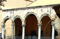 Heraklion old town The Basilica of Saint Mark is one of the most important Venetian buildings-monuments in Heraklion. Today it houses the city’s Municipal Art Gallery. The Venetians, wishing to consolidate their dominance over their new colony (Heraklion) and to express their gratitude and love for their mother country, built a church in the city’s centre dedicated to Saint Mark, patron saint of Venice. The Basilica managed to survive various earthquakes which afflicted Heraklion over the centuries with only minor repairs. During the Turkish rule it was converted into a mosque, the Defterdar Mosque, named after Defterdar Ahmet Pasha, the head of the financial department. The Ottomans demolished the bell-tower of the basilica and raised a minaret in its place, which in its turn was taken down by the residents of Heraklion after the liberation of the island in their attempt to erase the unpleasant reminders and symbols of the Turkish occupation.
Image Library
 Pediada, Iraklion Village of the area of Kastelli with 115 residents, Agia Paraskevi is situated 5 km northeast of Kastelli at an altitude of 400m. It is first mentioned in the Turkish census of 1671 as Agia Paraskevi tou Xourdou with 17 haratsia (head tax). It is very possible that Santa Venerata, a village mentioned in 1463 by Cardinal Bissarion, is the name by which Agia Paraskevi was known at that period.  Pediada, Iraklion Amariano, a charming small village of 321 inhabitants, (census 2001), lies in the western foothills of Afendi mountain, at an altitude of 530m. It is located at 7, 2 km east of Kastelli and can be found on the road axis; Kasteli -Xidas- Kastamonitsa-Amariano. With the traditional, century old plane tree in the middle of the village square, with the fountain, surrounded by kafeneions (traditional cafes) serving refreshments; raki (or tsikoudia, the traditional Cretan spirit) and mezedes (tit-bits), Amariano is a typical Cretan village, well worth a look. Until recently, the leather tannery was a main activity among the villagers. The main produce today are olive oil, raisins and grapes, although there is also livestock. Close by is the church of Agios Giorgos Kefaliotis with good quality wall paintings. The cultural centre of Amariano organises a great feast on August 15th, the Dormition of Theotokos and on September 20th, day of the patron saint, Aghios Eustathios. This can be a great occasion for any visitor to live an authentic cultural experience, to meet the people and taste the traditional Cretan cuisine. The first mention of the village -Amariano and Mariano- is to be found in inscriptions dating back to 1394-1399. Fr. Barozzi also mentions it in the region of Pediada in 1577. The name is significant: Amari is an area close to the town of Rethymnon, therefore the first inhabitants were originally from the Amari region. During the second Byzantine period, this region was known as Apano Syvritos and the name Amari is first mention in Venetian times. This would imply that the village was first founded during the Venetian conquest of the island. The first spelling, Amarianos, is the correct one and the family names Amarianos, Amargianitakis and Amariotis first appear in the 16th century, in the 1583 cencus. Image Library
 Pediada, Iraklion Apostoloi (GR: Αποστόλοι) is a village in the area of Kasteli, 360 m above sea level. It has about 490 inhabitants, and is located on the 32 km of the road leading to Kasteli in the NW part of Apostolianos Kampos, among vineyards and olive groves. Until recently tannery was a main activity among the villagers. The earliest reference to the name is to be found in a contract drawn in 1279, where Sancti Apostoli et Sophoro were lands belonging to the Venetian lord Leonardus Gradonicus, who gave them and leased them to Petro Quinino. There is another mention of the name in a document dated to 1378. It is also quoted by Fr. Barozzi in 1577 as forming part of the Pediada district. The name of the village finds its origins in the name of an old church dedicated to the Saint Apostles. The present church was built on the same site in the 19th century, in 1876. The church of Agios Giorgos is Byzantine and has wall paintings. According to village tradition, on the night of Easter in 1841, the Turks caught the Cretan leader of the revolution for the Eastern part of the island, Giorgos Vassilakis, or Vassilakogiorgi and hanged him from a fig tree.The village kapheneions serve particularly good raki and on June 29th there is a great feast in the honour of the Saint Apostles, Peter and Paul.  Pediada, Iraklion Armacha (GR: Αρμάχα) lies at 490 m above sea level, at a distance of 7km from Kastelli, with 110 residents (census 2001) and is first referred to by Barozzi in 1577. Armacha is rich in the production of agricultural and livestock products. The Metropolitan Bishop, Tirnovos Voulgaria Ilarionas Kabanaris Sinitis was born, and is also buried here. A man of advanced learning, he wanted to translate the Bible to Demotic Greek.  Pediada, Iraklion 330 m above sea level, just out of Kasteli (1.5 km) to the east, lies the village of Archangelos (GR: Αρχάγγελος) with 433 residents. It was founded in 961 by the military forces of Nikiphoros Phocas and was originally named ‘Varvaro’, and was still known by that name in 1583, where the Chandax Register puts it down as a village of the Pediada district with 37 inhabitants. Its name was changed only recently, in 1961, to Archangelos, and the main village church in the square is dedicated to the Archangel Michael. There is another smaller and older church, that of the Panaghia, with Byzantine wall paintings. Remains of ancient mills can still be seen. In a location known as Trochalos, archaeological finds have brought to light a series of Minoan tools dating back to the first and second Late Minoan periods. As in every Cretan village, raki and ‘mezedes’ are always available at the kapheneions. The feast of Michail Archangelos on November 8th is celebrated with much feasting in the village.  Pediada, Iraklion Askoi (GR: Ασκοί) is small village in the municipality of Kasteli has 315 inhabitants. It lies in the foothills of the Dikti mountain, 11 km to the east of Kasteli and 8 km from Lyttos. Fr. Barozzi mentions it as Ascus, in the Pediada district, in 1577. Recently a ritual clay figurine of the Mid-Minoan period was fortuitously unearthed on a peak close to the village. The remains of a large building belonging to a peak sanctuary have been excavated at Amygdalokefalo to the NE of the village. A reference in a contract of 1271, mentions how Petri Comarii from the village (casali) Maski owes Ruggerino Temisano, resident in Chandax, 25 «mistata» of good Cretan wine from his vineyards in Maski. Among other natural beauties, the ravine at Aski is well worth seeing. On December 4th the village has a typical Cretan feast to honour Agia Varvara. And as in every Cretan village, raki and ‘mezedes’ are always available at the kafeneions. Image Library
 Pediada, Iraklion Geraki (GR: Γεράκι). This lovely village of 375 inhabitants is located on the western slopes of the Lassithi mountains between the peaks of Afendi (1578 m) and Sarakinos (1588 m) in a beautiful glen, 520m above sea level and only 9km SE of Kastelli. It features an interesting Byzantine church, dedicated to the Archangel Michael (Archangelos Michail) with wall paintings that have not been maintained and some interesting (movable) icons by the local painter, Sepis. The active cultural centre of Geraki organizes many events during the summer season. Twice a year the village has a typical Cretan feast in honour of its patron saints: Agia Paraskevi on July 26th and Michail Archangelos on 8th November. The village produces agricultural products and great cheese that led to a specific cheese celebration. From Geraki you can also reach the lovely chapel of Agia Anna, driving through a particularly beautiful landscape with a spectacular view over the Geraki glen and fresh running water, a place ideal for a picnic. Image Library
 Pediada, Iraklion A beautiful small settlement, with 48 people, Epano Karouziana (GR: Επάνω Καρουζανά) lies at an altitude of 380m and is located at 40km from Herakleion. It is mentioned for the first time in 1842, its name was taken by a family name "Karouzos" common in the village. The village offers a spectacular view, picturesque paved lanes, traditional kafeneia and taverns and is a popular with tourists, especially in the summer when many Cretan evenings are organized with local music and dance.  Pediada, Iraklion Anbother beautiful small settlement, with 38 people, Kato Karouziana (GR: Κάτω Καρουζανά) lies at an altitude of 300m and is located at 49km from Herakleion and 1km from Epano Karouzana. It offers a spectacular view to the Kastelli plain, picturesque paved lanes, traditional kafeneia and taverns and is a popular with tourists, especially in the summer when many Cretan evenings are organized with local music and dance. |
||
|
| ||


C
O
N
T
E
N
T
S
O
N
T
E
N
T
S