interkriti®
YOUR GATEWAY TO CRETE
HOME
CRETE FACTS
NAVIGATE
EXPLORE

Agia Galini
Triopetra
Kissamos
Chryssi Isl.
Agia Marina
Balos
Gavdos isl.
Georgioupolis
SAMARIA
IDA Mtn
Palaiochora
Agia Roumeli
Sfakaki
Bali
Kalamaki
Matala
Lassithi
Plateau Lendas
Tsoutsouros
Vianos
Myrtos
Sfakia
Plakias
Ierapetra
Makrygialos
ZAKROS
Vai
Sitia
Agios Nikolaos
Elounda
MALIA
Hersonissos
Gouves
Chania
Rethymnon
Heraklion
GORTYN
FESTOS
KNOSSOS
|
|
Crete
List Grid Map
Found
160
- Showing :
41 - 60
 South east Iraklion at 16.9km (SE) Historical place with outstanding natural beauty, unspoiled villages and great beaches. The town of Ano Viannos is built amphitheatrically on the southern slopes of Dikti mountain at 560 m. above sea in a distance of 65km from Iraklion and 40km from Ierapetra. It preserves the traditional character with the narrow paved streets, the stone built houses - especially the "Plaka' quarter - the old kefeneios with tables under the plane trees and old churches such as Agios Georgios and Agia Pelagia with wall paintings dating back to the 14th century. There are a few accommodation facilities, banks, medical center, taverns, gas stations, shops etc. Ano Viannos is the seat of the municipality of Viannos.
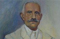 born in Viannos at 16.9km (SE) Author and journalist(1862-1920). He was born in the village Ano Viannos in 1862. In his childhood he moved with his family in Piraeus. Quite soon though, only 3 years later, they got back at their special homeland and there, he finished the elementary school. Though he'd started attending high school in Iraklion, he finished it in Varvakeio School, in Athens. His first novel was published in the newspaper 'Estia', in 1884. He was enrolled in the Philosophy School, but he never graduated. In 1885 he got back in Crete, where he took a job as a teacher in Modi, Kydonias. His revolutionary character motivated him into writing patriotic articles in the local paper, an act that infuriated the Turkish occupants to such an extent that he had to flee in Athens, only this time he stayed permanently. In Athens he worked for several newspapers like 'Estia', 'Asty' and 'Embros'. For more than 20 years he kept writing chronicles, which helped him win respect among the intellectuals. He used to use the pseudonym 'Diavatis' (Passer-by). During his long literary career he wrote: 'Gramvoussa, i epanastasis en Kriti' (Gramvoussa, the revolution in Crete), 'I olokaftossis tou Arkadiou' (The Holocaust of Arkadi), 'Otan imoun daskalos' (When I was a teacher), 'Proti Agapi' (First Love), 'Eno diavaina' (When I was passing by), 'O Patouchas', 'Zampeliou Kai Kritovoulidou, Istoria Kritikon Epanastaseon' (Zampeliou and Kritovoulidou, Cretan Revolutions History), 'Imere kindynon kai fovou' (Days in danger and terror). Kondylakis’ entire work is collected in his 'Apanta' (Collected works).Ioannis Kondylakis died in Irakleion, in 1920.  Gouves, Iraklion at 17km (N) At a height of 140m. above sea-level, this village has 142 inhabitants and is 22.5 kms away from Iraklion. According to the villagers, the name comes from the church of Aghios Nikolaos Skotino at the entrance of a cave. It was built at the end of the Venetian period. Today an extra wing has been added, dedicated to Aghios Charalambos. This church of Aghios Nikolaos Skotino presumably functioned as a "Hedge School" (or "Hidden School") under Turkish rule when education had been banned. When the locals said: "We are going to Skotino (which also means "darkness")", they meant they were going to school. Turkish administration refers to this place as Skotino Perasma in 1671. Very close to the village (1.5 km) the cave of Aghia Paraskevi draws crowds of tourists and is well worth a visit.  Skotino,Gouves, Iraklion at 17.5km (N) This is one of the three largest caves in the prefecture of Heraklion. It lies at half an hour distance to the north-west from the village of Skotino and is at a height of 225 m. above sea-level. The entrance to the cave is impressive: a large arch, 27 m wide and 10 m high. To the right one can see the ruins of an ancient chapel on which the modern chapel dedicated to Aghia Paraskevi was built. There is a feast held in front of the chapel on July 26th .
The Crete Golf Club Hersonissos, Pediada at 17.7km (NE) 18 holes in a desert course design. Each hole individually sculptured, seamlessly blending into the existing landscape...The new Bob Hunt masterpiece (head of design at the PGA Golf Management Ltd of Great Britain), is best described as a desert golf course hewn out of rolling landscape little more than half an hour from the international airport of Heraklion. It boasts a series of memorable holes that will test every aspect of a golfer's repertoire and offers stunning views over mountainous landscape that has hardly changed since the Minoan era back in 2600 to 1100 BC.  Kenouriou, Iraklion at 18.1km (W) Doúli (GR: Δούλι) is a village in Kenouriou county, located 38 km from Iraklion at an altitude of 440 m above sea level. The earliest reference to it, is to be found in the Duke's Archives of 1372, where it is mentioned as the feudal property of Nic. Venerio. The name figures in all the Venetian censi of the 16th and 17th centuries, as well as in the Turkish (1671) and Egyptian (1834) censi. In 1881, Douli forms part of the municipality of Megali Vrisi with about 170 inhabitants, and again in 1900 with only 21 inhabitants. As of 1920, Douli is a commune in its own right, and today Douli has about 240 residents. The patron saint of the village is Aghios Panteleimonas and the feast of the Saint is celebrated on July 27th.A visit to the old church of Aghios Nikolaos is also a must. For those interested in paleontology, there are fossils to be found at the location 'Pirgos'. Petra & Fos pizzeria - cafe bar Tsoutsouros at 18.3km (S) Delicious pizza in the wood heated oven, wonderful surroundings, ice cold beer, just by the libyan sea.
 Monofatsi, South Iraklion at 18.3km (S) Tsoutsouros (GR: Τσούτσουρος) is a small village on the southern coast of Iraklion prefecture, with lovely beaches and a small harbour. The ancient city of Inatos, used to stand were Tsoutsouros is now. Inatos served as a port to Priansos a renowned city - state of the Hellenistic time, located near the village of Kasteliana. Tsoutsouros is a popular tourist resort especially with Greek families. There are many taverns and cafes most of them around the small harbour, and a good choice of apartments and hotels along the beach. Image Library
 Seli Ampelou, Lassithi Plateau at 18.3km (E) It is the most significant group of windmills preserved on Crete. It occupies the northern entrance to the Lasithi plateau and is the landmark of the whole area. Today 24 windmills are preserved (out of the original 26), 7 of which extend to the south of the road that enters the plateau while the rest are built to the north of it. All the mills belong to the one-sided type of windmill, that grinds in a standard position, always on the same direction of the wind. Windmills of this type are preserved on Crete and on Carpathos but the Cretan ones are generally more carefully built and more elegant. The group of windmills has been declared a work of art since 1986. The mills belong to individuals and some of them have been restored while others still remain half-ruined. Source: The Hellenic Ministry of Culture  Krassas, Tsoutsouros at 18.4km (S) Palm House is a beautiful stone-built house on the south coast of Ceete. It is built on a tree-lined plot with panoramic sea views ,ideal for comfortable accommodation for 4 people. Its distance from the sea is only 300 meters.
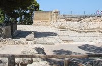
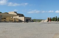
 Gouves, Iraklion at 18.5km (N) Pano Gouves (GR: Πάνω Γούβες) is a village of the district of Pediada in the prefecture of Iraklion at a height of 100 metres above sea-level. It lies twenty kms away from Iraklion, to the right at 17.3 kms on the National Road to Aghios Nikolaos. The village is built on the western flanks of the Ederi hill (322 m.). The name comes from "edera" which means ivy and symbolises affection. The name Gouves, on the other hand, comes from Gouva and means a hollow in the earth. It also means, in Crete, a hole in which during the middle ages, people stored their wheat. The earliest reference we have of the village is that of "Guves" in 1387 documents of the Duke’s archives in Chandax. Later on, in 1577, Fr. Barozzi mentions "Guvos" in the district of Pediados, and then "Guves" in the 1583 Register, with 252 inhabitants. Finally, in 1630, Vassilikata refers to "Vuves’. This is the birthplace of the poet Ioannis Konstantinidis. There are several outstanding churches in the village, among them: Zoodochos Pigis, Aghios Giorgos, Aghios Ioannis and Panayia (dedicated to the birth of Our Lady).  Krasas, Tsoutsouros at 18.6km (S) Seaside Houses located an hour drive (60kms) from Heraklion's airport at Tsoutsouros village. The houses are on the top of a headland separating two bays with magnificent beaches - the one almost private! - constituting a majestic scenery of virgin Crete with both sea and mountain view. Unique place for those who seek privacy, peace and romantic mood. The houses are fully equipped and have large shaded verandas. Prices from € 160/ night (2people)  Palace and Archaeological site at 18.8km (NW) The famous Palace of king Minos and the centre of the Minoan civilisation 5km south of Iraklion. The Great Palace covered an area of 20.000 sq. meters and had 1.400 rooms. Every section of the Palace had a specific use. In the west side of the Palace were the chambers of the ceremonies, of the administration and of the public storehouse...
Image Library
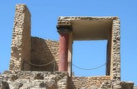
 Knossos Palace at 18.8km (S) The "West Porch" was a roofed area opening onto the Court, supported by one column of which part of the gypsum base remains. The east wall was decorated with a bull-leaping fresco. There was a small "guard-room" at the back. The porch was closed off by a double door and from here began the long "Corridor of the Procession". Image Library
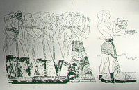 Knossos Palace at 18.8km (S) The Corridor of the Procession is named from the wall painting decorating its east wall and depicting a procession of musicians and other people holding gifts. The floor was very fine. The "Corridor of the Procession", according to Evans, initially led to the "South Propylaeum" and continued on to the Central Court. Today a causeway made of wood, with handrail, stands in its place, so the visitors can follow the same route. Image Library
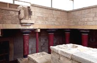
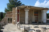 Knossos Palace at 18.8km (S) The "South Propylaeum", as we see it today, is a result of the restoration of Evans who put up a copy of the "Cup-Bearer" fresco here. The wall painting depicted a man holding a libation vase (rhyton). Its theme is connected with the "Procession Fresco" which, according to Evans, reached here, the "South Propylaeum". The pithoi (large storage jars) on the east side of the Propylaeum belong to the Postpalatial Period (1450-1100 B.C.), and indicate that the area was later used for storage.
Image Library
 Knossos Palace at 18.8km (S) The south part and south facade of the palace is very eroded. Today one can only see foundations on tiered levels. At the bottom, a tower-like projection is all that remains of the south entrance to the Palace. An asceding corridor led to the Central Court. The section of the corridor closest to the Central Court was reconstructed by Evans who put here a copy of a relief wall painting, of which only few fragments were found. On these fragments, it was possible to make out a figure wearing jewellery in the shape of lilies. The reconstruction we see here is uncertain. In Evans's opinion, it represented the "Priest-King". Other scholars think that it is a prince, whilst others believe it depicts a female figure. Anyway the original fresco which is known as the "Prince of Lilies" is one of the masterpieces in the collection of the Heraklion Museum. Image Library
 Knossos Palace at 18.8km (S) The Central Court (dimensions ca. 50m x 25 m.) is an architectural element common to all Minoan palaces. The Court connects the different wings with one another. There was also direct access from outside the Palace. Part of the paving, which once covered the whole court, is preserved in the northwest and southwest corners, whilst near the "Throne Room", parts of the drainage system can be made out which ensured the evacuation of rain water. It is thought that the area must have been for meetings and rituals of both a sacred and profane character The orientation of the Central Court was north-south with a clear view of the sacred Mount Giouhtas, where an important sanctuary was located. Image Library
 Knossos Palace at 18.8km (S) A large part of the east wing cannot be seen from the Central Court as it is built into the side of the hill on top of which lies the rest of the Palace. It is one of the most interesting parts of the palace because two storeys are preserved below the level of the Central Court. Today, a large part of it has been reconstructed in concrete. The storeys are connected with one another by means of a system of stairs known as the "Grand Staircase". The staircase was found during the excavation in its original position. There is a total of four flights of stairs, two for each storey. The two lower flights are preserved as they were found. The steps are broad and deep, with a gentle incline that makes for an easy ascent. The staircase is lit by a large light-well and was surrounded by a colonnade of wooden columns. The Grand Staircase The Grand Staircase The Grand Staircase & Hall of Colonades - First floor The Grand Staircase & Hall of Colonades - Ground floor A series of corridors, spacious halls and small rooms is connected to the Grand Staircase. Evans, who believed that the Palace was the seat of the king of Knossos, hypnothesized that the residential quarters of the Royal family lay in this part of the site. 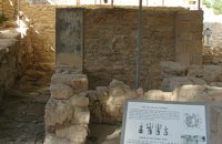 Knossos Palace at 18.8km (S) This room lies at the southern part of east wing in an area with many small rooms (possibly storerooms and magazines), lustral basins and light-wells. It was made into a shrine at the end of the Postpalatial period (1375-1200 B.C.). It is known as the "Shrine of the Double Axes". On a bench at the back, different ritual objects were found amongst which were a stone double axe and votive clay idols - among them the terracotta figurine of a goddess with upraised arms. Similar small shrines have been found in houses of the same period.
Image Library
|
||
|
| ||

;)
;)
;)
;)
C
O
N
T
E
N
T
S
O
N
T
E
N
T
S